Offa's Dyke — early medieval earthwork along the England–Wales border
Offa's Dyke is a large early medieval linear earthwork that roughly traces the England–Wales frontier. Its attribution to King Offa, date and original function remain subjects of archaeological study.
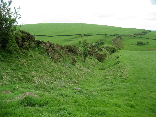
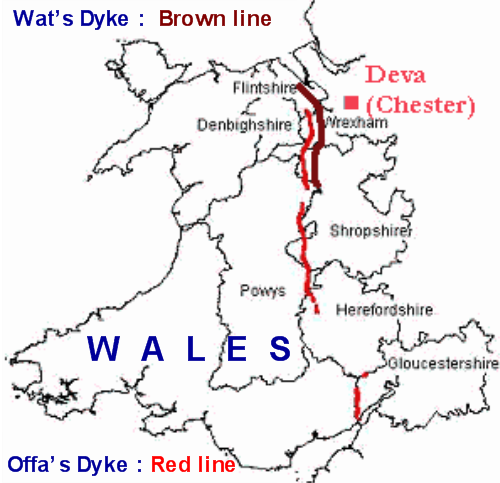
Offa's Dyke is a major linear earthwork running for much of the length of the modern boundary between England and Wales. In Welsh it is commonly called Clawdd Offa. The monument consists of a raised bank and an accompanying ditch, usually with the ditch placed on the western (Welsh) side of the bank. Its preservation varies: in places the bank survives as a clear embankment several metres high, while in other places only shallow traces remain. The dyke is generally associated with Offa, the 8th-century ruler of Mercia, but the detailed chronology, authorship and purpose are debated.
Image gallery
5 Images


Route and dimensions
The course does not form a continuous wall but is a series of earthwork segments that traverse low ground, hills and river valleys. Where well preserved the dyke as a feature of bank plus ditch can be very broad: some descriptions give a combined width up to about 65 feet (20 metres) and a surviving bank height commonly reported up to around 8 feet (2.4 metres). The route marks a rough east–west contrast in landscape and has long been treated as a frontier line between Anglo-Saxon Mercia and Welsh polities.
Origins, dating and political context
The dyke is widely attributed to late 8th-century political activity under King Offa of Mercia, and it broadly follows a zone between Anglian Mercia and Welsh kingdoms such as Powys. Excavation and archaeological survey indicate that construction probably took place in phases rather than as a single, continuous project, and that not every surviving section dates to the same decade. Suggested functions include a defensive barrier to control movement, a demarcation of territory, an administrative frontier, or a combination of symbolic and practical purposes. Documentary evidence from the period is limited, so archaeological methods—trenches, stratigraphy and radiocarbon dating—are central to building chronologies.
Archaeology and construction
Fieldwork has revealed variable construction techniques: earth dug from a ditch was heaped to form a bank, sometimes reinforced by revetment or occupation layers where later activity occurred. The frequent placement of the ditch on the western side suggests the bank faced eastwards, possibly indicating a design intended to control movement from Wales into Mercia. Many sections show later modification by agriculture, road-building and other post-medieval changes, complicating interpretation of the original profile.
Offa's Dyke Path and public access
A modern long-distance trail, the Offa's Dyke Path, follows the dyke's central corridor and provides public access to several of the most impressive sections. The trail runs from Prestatyn on the north Welsh coast to the area near Chepstow and the Severn Estuary in the south. The path showcases upland views and river valleys and links numerous historic and natural sites along its length. Much of the line is a Public Right of Way, and popular stretches attract walkers, historians and naturalists.
Protection, conservation and notable incidents
Many stretches of Offa's Dyke are protected as scheduled monuments and lie within designated landscapes such as Sites of Special Scientific Interest and Areas of Outstanding Natural Beauty. Conservation efforts combine archaeological recording, land-management agreements and public engagement to stabilise fragile sections and reduce erosion from foot traffic. Despite protections, the dyke has suffered damage from agriculture, development and isolated deliberate actions. A high-profile case in 2013 involved the removal of a short stretch to build stables; the incident prompted strong public comment and comparisons in the press to driving a road through Stonehenge, underlining conflicts that can arise between private land use and heritage protection.
Cultural and research significance
Offa's Dyke remains an important focus for research into early medieval frontiers, state formation and Anglo-Welsh interaction. Its scale and survival make it a valuable landscape source: archaeologists and historians study the dyke alongside place-names, documentary references and environmental data to better understand how borders were made and experienced. Community archaeology, mapping projects and the long-distance path also keep the monument an active part of public heritage and countryside recreation.
- Main features: earth bank with flanking ditch, variable preservation.
- Associations: traditionally linked to Offa and Mercia, boundary with Powys and other Welsh kingdoms.
- Protection: scheduled monument status and inclusion within protected landscapes.
Offa's Dyke continues to interest walkers, scholars and local communities as both a physical remnant of early medieval frontier-making and a living component of the modern Anglo‑Welsh border landscape.
Questions and answers
Q: What is Offa's Dyke?
A: Offa's Dyke is a large earthwork that roughly follows the current border between England and Wales. It was named after Offa, an 8th century king of Mercia who is believed to have ordered its construction.
Q: What is the purpose of Offa's Dyke?
A: The original purpose of Offa's Dyke is not known for sure, but it followed the border between Anglian Mercia and the Welsh kingdom of Powys.
Q: How wide and high was Offa's Dyke?
A: Offa's Dyke was up to 65 feet (20 m) wide (including its flanking ditch) and 8 feet (2.4 m) high.
Q: Is there a footpath associated with it?
A: Yes, there is a 177 mile (283 km) footpath called the 'Offa's Dyke Path' which runs between Prestatyn in the north (Liverpool Bay) and Sedbury, near Chepstow (the Severn Estuary). This path runs near the dyke in its central part.
Q: Are there any special designations related to this structure?
A: Yes, some sections of the dyke are defined as Sites of Special Scientific Interest, and Areas of Outstanding Natural Beauty. Most sections are also designated as Public Rights of Way including those sections which form part of the Offa's Dyke Path.
Q: Has anything happened to parts or all of it recently?
A: In August 2013, a 45 m (148 ft) section of the dyke located between Chirk and Llangollen was destroyed by a local landowner in order to build stables - this destruction has been compared to "driving a road through Stonehenge".
Related articles
Author
AlegsaOnline.com Offa's Dyke — early medieval earthwork along the England–Wales border Leandro Alegsa
URL: https://en.alegsaonline.com/art/72028