
Oder (Odra) — Central European river
The Oder (Polish Odra) is a major Central European river rising in the Czech Republic, flowing through Poland and forming part of the Poland–Germany border before reaching the Baltic Sea via the Szczecin Lagoon.

The Oder (Polish: Odra; Czech: Odra) is a principal river of Central Europe that rises in the Czech lands and flows north through Poland to the Baltic Sea. For much of its lower reach the Oder forms the international border between Poland and Germany. Its course and basin have shaped regional settlement, industry and transport for centuries and the river remains important for navigation, ecology and cross‑border cooperation.
Image gallery
9 Images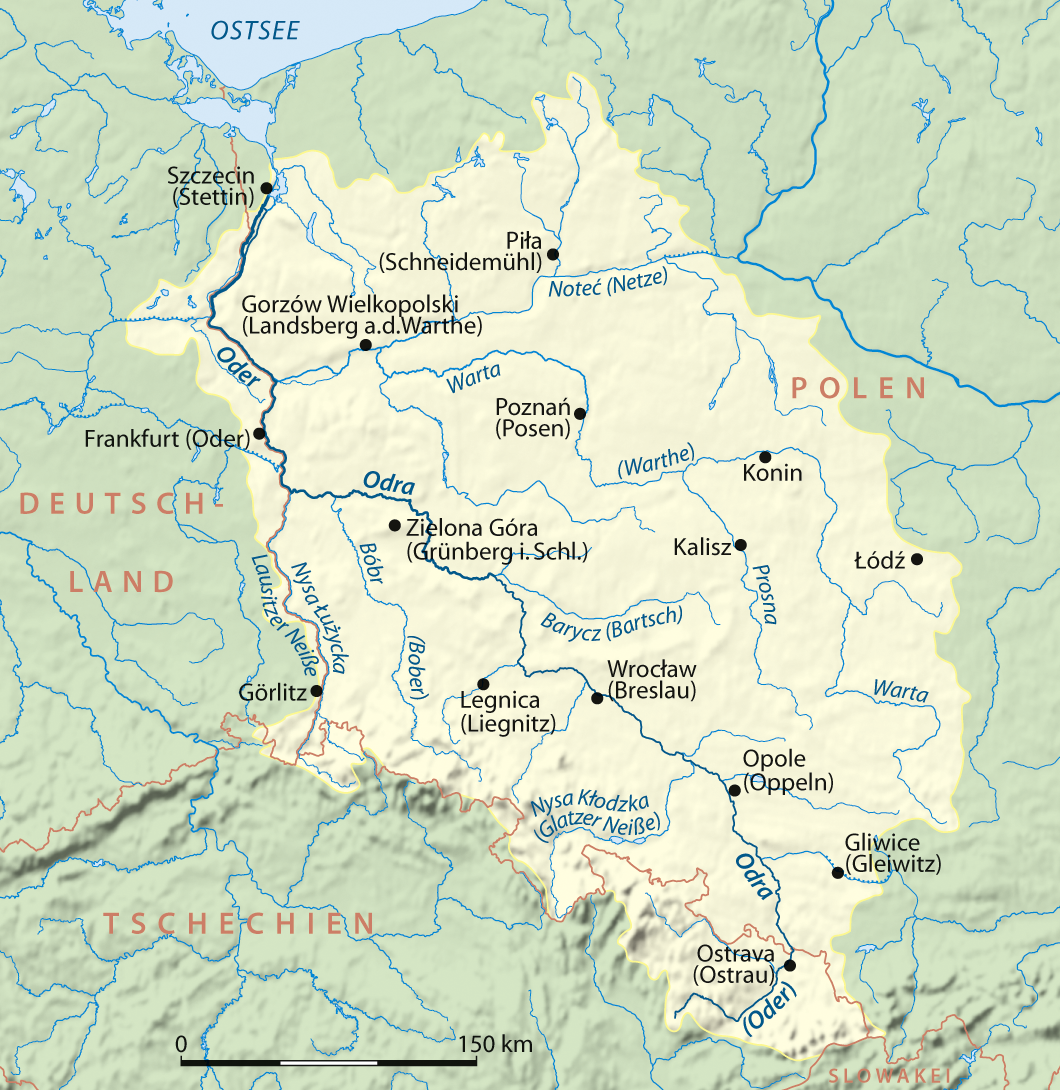


Physical characteristics and course
The Oder’s commonly cited length is about 866 kilometres (some measures extend to the sea entrance at Świnoujście). It drains a large catchment that collects water from southern Poland, part of the Czech Republic and eastern Germany. The river reaches the Baltic Sea through the Szczecin (Stettin) Lagoon and flows around the islands of Usedom and Wolin before entering the open sea.
Mean discharge at the mouth into the Szczecin Lagoon is typically reported around 574 cubic metres per second. The basin lies between the catchments of the Elbe to the west, the Vistula to the east and the Danube to the south; its landscapes range from upland headwaters to wide lowland plains and brackish lagoon at the mouth.
Tributaries, towns and infrastructure
The Oder receives water from several important tributaries. The most notable are:
- Warta — the longest significant tributary; including the Warta system extends the river network’s total length to over 1,040 kilometres.
- Lausitzer (Lusatian) Neisse — a principal eastern tributary that also forms part of the modern Poland–Germany boundary further downstream.
- Other tributaries and smaller streams that feed the river across Silesia and western Poland.
Major cities on the Oder include Wrocław (historic Breslau), Opole and Szczecin near the mouth. The river is navigable along much of its length and connects to inland waterways and industrial regions by canals such as the historic links to Upper Silesia and to the Havel–Elbe network, enabling freight and river traffic between Poland and Germany.
History and political importance
The Oder has long marked internal cultural and political regions of Central Europe. After the Second World War the river’s lower course became central to post‑war borders: the Oder–Neisse line was established as the frontier between Poland and Germany, an adjustment with lasting geopolitical consequences. Historically the river corridor supported towns, mills and trade routes linking the Baltic to Central Europe.
Uses, ecology and notable events
The Oder supports commercial navigation, regional ports and fisheries, and its floodplains provide important habitats for birds and wetland species. Like many large rivers passing through industrial regions, it has faced pollution and habitat alteration in the 19th and 20th centuries; ongoing monitoring and restoration efforts aim to improve water quality and ecological connectivity.
Flooding is a recurring risk on sections of the Oder. One of the most widely remembered recent events was the severe summer floods of 1997 that affected Poland, the Czech Republic and Germany, causing extensive damage in urban and rural areas and prompting investments in flood defenses and river management.
Notable facts and management
- The Oder is one of the largest rivers entering the Baltic Sea and — by some measures of flow within Germany — ranks among the country’s major rivers.
- Its transboundary character requires international cooperation on navigation, flood control, water quality and habitat protection; Germany, Poland and the Czech Republic coordinate through bilateral and regional agreements.
- The Szczecin Lagoon and adjacent coastal waters form an ecologically and economically important estuarine zone where freshwater and brackish ecosystems meet.
History
The Odra Spring is located in the Czech Republic one and a half kilometres northwest of Kozlov at Fidlův kopec (Fiedelhübel) in the Moravian Odra Mountains. The first 31 kilometres of its course run through the Libavá military training area. From its border, from the confluence of the Budišovka to Ostrava, it forms the historical provincial border between Silesia (on the left) and Moravia (on the right). At Bohumín, the river crosses the border between the Czech Republic and Poland at the confluence of the Olsa at 195 m above sea level. The river course on Czech territory has a length of 131 kilometres and covers a catchment area of 10,288 square kilometres.
On its further course the Oder flows through Silesia and its capital Wrocław. From the mouth of the river Neisse at Ratzdorf north of Guben in Brandenburg, its middle to the branch of the West Oder north of Schwedt/Oder marks the border between Poland and Germany and is accordingly called the Grenzoder. The Oder flows through Frankfurt (Oder), Słubice and Kostrzyn nad Odrą (Küstrin). Between the towns of Lebus and Oderberg, the Oder flows through the Oderbruch, which is almost 60 kilometres long and 12 to 20 kilometres wide, then passes the polder area near Schwedt, before it divides at river kilometre 704 at the weir Marienhof into the two arms Westoder (Polish: Odra Zachodnia) and Ostoder (Polish: Odra Wschodnia). The Westoder is a border river until Mescherin, before it continues to flow on both sides on Polish territory like the Ostoder. The gradient of the last 30 kilometres before Szczecin is only a few centimetres. From river kilometre 730.5 the Ostoder is called Große Reglitz (Polish: Regalica). At the level of the Dammsche See, the East and West Oder merge. As so-called Papenwasser (Polish: Roztoka Odrzańska), the Oder flows through Police (Pölitz) before it flows into the Szczecin Lagoon, which belongs to the Baltic Sea. The Odra river basin here covers 118,890 km². According to Polish law, the Odra river is considered as internal sea water from the Hakenterrace onwards and does not count as inland water from there onwards.
The border sections of the Oder and the Westoder are federal waterways of waterway class IV with a total length of 179 kilometres, for which the Waterways and Shipping Authority Eberswalde is responsible.
As the Szczecin Lagoon is a sea bay, its three connecting arms to the open sea are sea arms. As estuaries of the Odra river they mainly transport Odra water to the north, but they also have a considerable inflow of seawater into the lagoon, especially during strong northerly winds. This can be seen in the backward (lagoon-side) delta formations, especially pronounced in the Swine. Location of these estuaries and islands:
- Peenestrom (until the confluence of the Peene River Der Strom) between the German mainland and the island of Usedom (Polish: Uznam),
- Świna (German Swine) between the islands of Usedom and Wollin (Polish Wolin), with the shipping lane, Kanał Piastowski, until 1945 Kaiserfahrt, built from 1875 to 1880,
- Dziwna (German Dievenow) between the island of Wollin and the Polish mainland.
The total discharge of the Odra river is 15 % via the Peene river, 73 % via the Swine river and 12 % via the Dziwna river.

Shipping
The Oder is navigable for 717 kilometres until Koźle (German Cosel) in Poland. There the Gliwice Canal connects, which was intended as the beginning of the Danube-Oder Canal.
The Oder, which is navigable for seagoing vessels from the Baltic Sea upstream through the Szczecin Lagoon to Stettin (Szczecin), has been shortened from 1,040 kilometres to 866 kilometres in length since about 1850 by straightening.
Extensive canalization of the river took place in two phases: 1888-1897 and 1907-1922. In order to make the river navigable for larger ships, barrages and locks were built, and at the same time hydropower was used at the barrages for the generation of electric current. Currently, seven hydroelectric power plants are in operation, the largest of which belongs to the Brzeg Dolny barrage and has a capacity of 9.7 MW.
Since July 2007, after 62 years, an occasional ferry has been operating again between the German village of Güstebieser Loose and the Polish village of Gozdowice (German Güstebiese). The vehicle is a motor ship with paddle wheel drive.
Questions and answers
Q: Where does the Oder River start?
A: The Oder River starts in the Czech Republic.
Q: How long is the Oder River?
A: The Oder River is 854 kilometres long.
Q: What body of water does the river end in?
A: The Oder River ends in the Szczecin Lagoon in the Baltic Sea.
Q: What countries does it flow through?
A: The Oder River flows through Poland and Germany.
Q: How much of the border between Poland and Germany is formed by the river?
A: The river forms 187 kilometers of the border between Poland and Germany.
Q: What are some towns that it passes through?
A: Some bigger towns that it passes through are Wrocław, Eisenhüttenstadt, Frankfurt on the Oder, Szczecin and Police.
Q: What is the biggest city on its course?
A: The biggest city on its course is Wrocław, located in Lower Silesia, Poland.
Related articles
Author
AlegsaOnline.com Oder (Odra) — Central European river Leandro Alegsa
URL: https://en.alegsaonline.com/art/71960
Sources
- libraryindex.com : Encyclopædia Britannica's 9th edition 1870–1890: Oder
- britannica.com : britannica.com/place/Oder-River