Oder–Neisse line
Post–World War II frontier between Germany and Poland largely following the Oder and Lusatian Neisse rivers; established after Allied decisions in 1945 and later confirmed by international treaties and European integration.
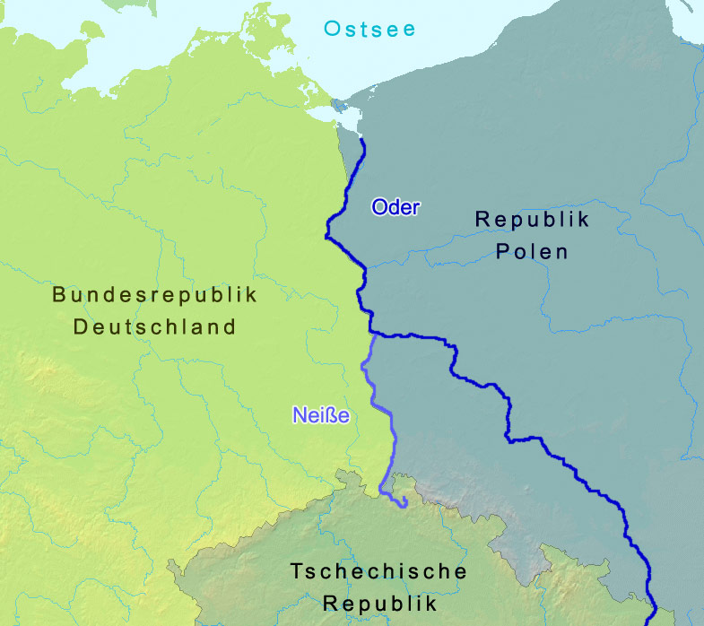
The Oder–Neisse line is the name given to the border established after the Second World War between Germany and Poland. It takes its name from two rivers that mark much of the boundary: the Oder (in Polish Odra) and the Lusatian Neisse (Nysa Łużycka). The frontier produced one of the largest territorial shifts in Central Europe in the 20th century, transferring lands that had been under German administration to Polish control and prompting wide-ranging political, demographic and cultural changes.
Image gallery
10 Images


Geography
For large stretches the border follows the Oder River and then the Lusatian Neisse before reaching the Baltic coast at the Oder Lagoon. The area affected includes territories long associated with historic regions such as Silesia, Pomerania and parts of Brandenburg. Several notable cities changed national administration after 1945, including Wrocław (formerly Breslau) and Szczecin (formerly Stettin); smaller river towns on both sides experienced equally profound alterations in administration and daily life.
Historical background to 1945
The lands east of the modern Oder–Neisse line have a complex history of shifting sovereignty. Before the late 18th‑century partitions many had been part of the Polish–Lithuanian Commonwealth; during the partitions and the nineteenth century they were incorporated into Prussia and later the German Empire. After the First World War some areas were transferred to the reconstituted Polish state, and interwar border adjustments reflected competing national claims in the region.
Decisions of 1945 and population movements
At the end of the Second World War the victorious Allies placed territories east of the Oder and Neisse under Polish administration pending a final peace settlement. These arrangements were implemented on the ground and accompanied by large population movements: many ethnic Germans fled before the advancing Soviet armies or were expelled in the months and years that followed. At the same time Poles displaced from areas east of the Curzon Line (territories incorporated into the Soviet Union) and from central Poland were resettled in the west, a process framed in Poland as the recovery or regaining of western lands.
Legal and diplomatic recognition
For decades the status of the border remained a sensitive diplomatic issue. East Germany formally accepted the border in the early postwar period, while successive West German governments were initially cautious about recognizing the postwar frontier as final. During the Cold War the border was the subject of treaties and confidence‑building measures; in the 1970s West Germany took steps toward normalization, and the German‑Polish border was definitively confirmed by treaty arrangements at the end of the Cold War and in 1990 between the two states.
Contemporary status and legacy
Since Poland and Germany became partners within European institutions and since Poland joined the Schengen Area, routine border controls have been removed, enabling cross‑border travel, trade and regional cooperation. The Oder–Neisse line remains a symbol of the 20th century’s violent reshaping of borders and populations, and it continues to shape policies on minority rights, historical memory, compensation claims and regional development. Contemporary efforts emphasize reconciliation, cultural exchange and shared environmental and economic management of the river basin.
Further reading and related topics
- Oder River
- Lusatian Neisse (Nysa Łużycka)
- Border and frontier concepts
- Germany: history and postwar changes
- Poland: territorial changes
- Second World War: European settlements
- Territorial transfer and population movements
- Prussian provinces and earlier cessions
- Treaties and settlements after the First World War
- Early modern European polities (e.g. Holy Roman Empire)
- Russian Empire and historical partitioning of Poland


Germany, Poland and Soviet Union until 1945
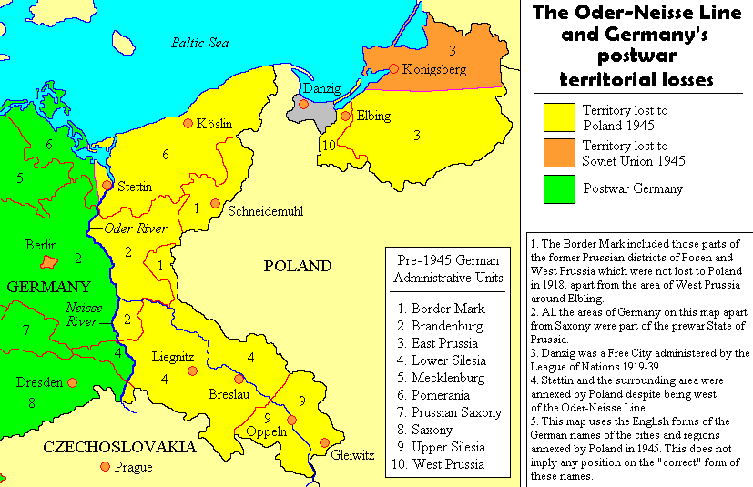
The areas of the German Reich placed under Polish administration after the Second World War by the Potsdam Decisions, as defined in 1937, comprised the areas of the Prussian provinces of Pomerania, Brandenburg, Lower and Upper Silesia (as parts of Silesia) to the east of the Saxon district of Zittau and the southern part of East Prussia. The population in these areas and in the Free City of Danzig, which had been independent since the Treaty of Versailles, was German-speaking until 1945, except for Polish-speaking portions in Upper Silesia (11%), Danzig (4%), and East Prussia (2%, mostly Masuria).
Poland, reborn after the end of the First World War in 1918, had demanded the annexation of all of Upper Silesia, Posen, West Prussia, Danzig and southern East Prussia at the Versailles Peace Conference. The claims were justified on the grounds of Polish-speaking populations and the fact that these territories had been under Polish rule in earlier centuries. They could not be fully enforced in the peace treaty, especially since the referendums in Upper Silesia, in the Marienwerder voting area, and in the Allenstein voting area resulted in majorities in favor of remaining with Germany. The final course of the border in eastern Upper Silesia was not determined until 1922.
On the eve of the Second World War, the two dictators Adolf Hitler and Josef Stalin defined the political-territorial spheres of interest of the German Reich and the Soviet Union in a secret additional protocol by agreeing on a German-Soviet demarcation line. This demarcation line was largely based on the Curzon Line proclaimed by the Western Allies in 1919, which was based on the ethnographic principle (cf. the adjacent diagram). Russia, under its Prime Minister Ivan Logginovich Goremykin, had already agreed with Roman Dmowski in 1915 on the procedure of using the ethnographic principle to determine Poland's eastern border.
In the secret Additional Protocol, the territories east of the Curzon Line conquered by Poland from 1919 to 1921 (Eastern Galicia in 1919, Volhynia in 1921, the former Russian-Lithuanian Governorate of Vilnius in 1920/22), which had belonged to Old Poland until the partitions of Poland in 1772-1795, were assigned to the Soviet sphere of interest (see Soviet Occupation of Eastern Poland).
In the areas of Poland annexed by Germany as well as in parts of the Generalgouvernement, the National Socialists pursued the goal of complete Germanization. Large parts of the Polish population were expelled from these areas. Parts of the Polish elite were murdered and many Poles were deported to the German Reich for forced labor.
In December 1942, Władysław Sikorski, the prime minister of the Polish government-in-exile in London, called the Oder the "naturally given security line" of Poland in a memorandum.

Allied policy on Germany up to the Potsdam Conference
The main issue for the three Allies at the Tehran Conference in the winter of 1943 was the division of Germany. Stalin wanted to keep the territories east of the Curzon Line (the parts of eastern Poland inhabited by a majority of White Russians and Ukrainians) that Soviet Russia had ceded to Poland in the 1921 Riga Peace Treaty after the lost Polish-Soviet War of 1920. He sought a boundary between the Soviet Union and the Polish Republic which, with the exception of the Bialystok district and some areas along the San River, corresponded to that already agreed upon in the Ribbentrop-Molotov Pact. Poland was to be compensated for this at the expense of Germany in the west and receive part of the territory which the Versailles Peace Treaty had recognized as German after the First World War. Stalin demanded the Oder as Poland's western border and the Curzon Line as Poland's eastern border, which amounted to a westward shift of Poland.
When the subject of German partition was continued at the Yalta Conference in February 1945, preliminary decisions had already been made. General de Gaulle had told Stalin in Moscow in December 1944 that he had nothing against a German border on the Oder and Neisse. Churchill had explained in the British House of Commons that it would be to Poland's advantage if she were to receive territories in the West that were richer than those she would have to cede in the East. On December 15, 1944, he made a speech in which he advocated the "complete expulsion" of the Germans from the future Polish western territories. Britain approved of the Oder line, including Szczecin, to the Polish government-in-exile. Only apparently the border question was still open, only its exact course was still disputed. Churchill and Roosevelt spoke at Yalta of the "Oder border", Stalin of the "Oder and Neisse". The Polish government-in-exile feared losing eastern Poland if it agreed to the Oder-Neisse border, and held fast to the Riga Peace border in the east. In the west, it demanded East Prussia, Danzig, Upper Silesia, and part of Pomerania. Stalin had set up a Communist government for Poland in July 1944 with the Lublin Committee, which accepted the Curzon Line in the east. In a secret treaty it had settled on the Oder-Neisse border. A settlement for the northernmost section of the Polish border was promised to the committee. On August 28, 1944, its chairman, Edward Osóbka-Morawski, had for the first time publicly demanded the Oder as Poland's western border. Beneš, the president of the Czechoslovak government-in-exile, also made himself an advocate of a westward shift of Poland at the expense of Germany and in favor of the Soviet Union. At the Yalta Conference, the basic decision on the future of Poland and the German eastern territories was finally made by Stalin, Churchill, and Roosevelt, without, however, already determining the course of Germany's eastern border. Germany was to be divided up and Poland was to be moved westwards.
It is unclear when Stalin decided where Poland's new western border was to be and when the Western Allies became aware of the actual future course of the border. A chance find in a Moscow archive proves that Stalin marked the Oder and the Glatzer Neisse as the western border on a map he had worked on with a pencil as late as the summer of 1944.
Related articles
Author
AlegsaOnline.com Oder–Neisse line Leandro Alegsa
URL: https://en.alegsaonline.com/art/71959