Nuuk — capital and largest city of Greenland
Overview of Nuuk: location, history, demographics, institutions, economy and notable features of Greenland's capital on the west coast.
Overview
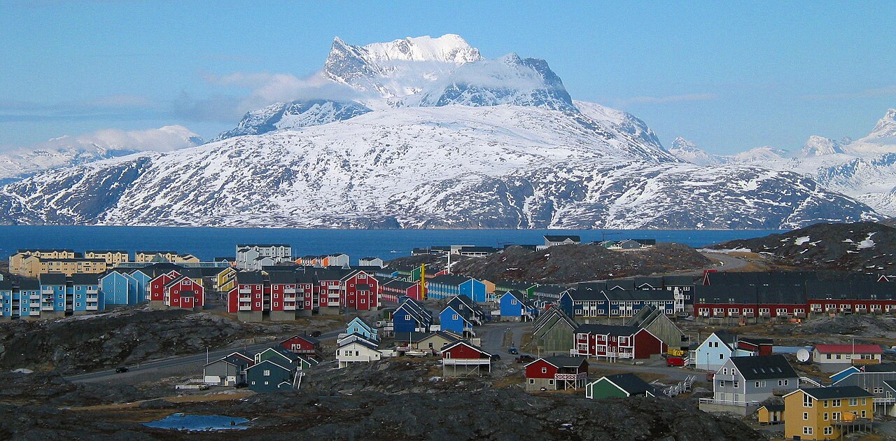
Nuuk is the capital and largest settlement of Greenland, located on the island's sheltered west coast at the mouth of the long fjord Nuup Kangerlua (Danish: Godthåb / Godthåbsfjorden). The town functions as Greenland's political, economic and cultural centre and is home to the national government and main public institutions. Its population is roughly 15,000, a mix of indigenous Inuit communities and people of European descent, especially descendants of Danish settlers.
Image gallery
10 Images


Geography and climate
Nuuk sits at the fjord's mouth where steep hills and glaciers shape dramatic scenery. It lies about 240 km south of the Arctic Circle, so the town experiences pronounced seasonal differences in daylight: long summer days and short winter days with polar twilight. The climate is high-Arctic maritime, with cool summers and cold, but moderated, winters compared with the interior ice sheet.
History
The modern settlement traces its founding to 1728, when the Norwegian missionary Hans Egede established a trading and mission post and gave the place the Danish name meaning “Good Hope.” Over the following centuries Nuuk developed as an administrative hub under Danish rule and later as the capital of home-rule and autonomous Greenland, concentrating government services, education and commerce.
Culture and institutions
As Greenland's centre for higher learning and culture, Nuuk hosts the University of Greenland and several museums, libraries and cultural centres that promote Greenlandic language, arts and history. Indigenous traditions coexist with contemporary urban life: hunting and fishing remain important to cultural identity even as public administration, education and service sectors grow.
Economy and transport
The local economy blends public administration, education, healthcare and services with traditional activities such as seafood harvesting. Nuuk is also a focal point for tourism, research and occasional mineral exploration. Transport links include an airport serving domestic and regional flights and maritime connections along Greenland's west coast; logistics remain shaped by fjords, sea ice and limited road links to other towns.
Notable facts and distinctions
- Nuuk is Greenland's primary political and cultural capital and the largest urban settlement in the territory.
- The town's bilingual character reflects Greenlandic Inuit heritage alongside Danish influence introduced during the colonial era by missionaries such as the early missionary presence.
- Its dramatic fjord landscape, Arctic light conditions and status as a gateway to inland ice and surrounding settlements make Nuuk important for science, tourism and regional governance.
Geography
Location
Nuuk lies on the western tip of a peninsula about 75 km long, bounded by Uummannap Sullua to the north and Fjord Ameralik to the south. South of Nuuk, this peninsula is divided by the fjord Kangerluarsunnguaq (Kobbefjord). Off the west coast of Nuuk runs Nuup Kangerlua (Godthåbsfjord), one of the longest and widest fjords in Greenland and the main branch of one of the country's largest fjord systems. The urban area grows around the bay Qinngorput (Malenebugt). South of this lie a number of other larger islands, the largest of which are Aqissersiorfik (Rypeø) and Angisunnguaq. The nearest inhabited place from Nuuk, Kapisillit, is about 75 km away in the inland part of the fjord system.
Climate
Nuuk is characterised by a maritime-subpolar climate. The annual mean temperature is just below freezing. Since the beginning of the 20th century, the annual mean temperatures (with the exception of 2010) have varied between -4 °C and 1 °C. The monthly mean temperature varies by less than 20 °C during the year, with the coldest month in March and the warmest in July. Precipitation is distributed throughout the year, with the rainiest months in summer and autumn. Overall, about one in three days in Greenland is a rainy day. Nuuk is less than 300 km south of the Arctic Circle, which has an effect on sunshine duration due to the polar days and nights.
| Nuuk | ||||||||||||||||||||||||||||||||||||||||||||||||
| Climate diagram | ||||||||||||||||||||||||||||||||||||||||||||||||
| ||||||||||||||||||||||||||||||||||||||||||||||||
| Monthly average temperatures and precipitation for Nuuk
Source: WetterKontor (1961-1990) | ||||||||||||||||||||||||||||||||||||||||||||||||||||||||||||||||||||||||||||||||||||||||||||||||||||||||||||||||||||||||||||||||||||||||||||||||||||||||||||||||||||||||||||||||||||||||||||||||||||||||||||||||||||||||||||||||||||||||||||||||||||||||||||||||||||||||||||||||||||||||||
City breakdown
Nuuk is the only town in Greenland that can be divided into districts. The other cities with less than 7000 inhabitants do not have the necessary size for this. Nuuk is divided into four districts: Nuuk in the narrower sense as the city centre, Nuussuaq, Quassussuup Tungaa and Qinngorput.
City centre
Nuuk proper, which has formed around the historic core, is located in the area west of the 400-rtalik road and south of Lake Qallussuaq. It has an area of about 3 km² and is home to just under half of the city's population. This is where most of the city's public and especially historic buildings are located, as well as Nuuk's passenger port.
Nuussuaq
Nuussuaq (German großes Kap) is the approx. 1.75 km² district that connects to the city centre on the eastern side of the 400-rtalik and thus also lies east of Umiarsualivik Bay, where the passenger port is located. The district area includes several islands, Umiarsualiviup Qeqertai (Qeqertat for short / Admiralitetsholmene in Danish), which have been artificially connected to the mainland and form the container port. In the strait Iggiaa between the Qeqertat and the mainland lies the city's boat harbour, which consists of 21 jetties.
Quassussuup Tungaa
Quassussuup Tungaa (German: Richtung des großen Bergrücken) is the name of the district located north of Nuuk and Nuussuaq. It has an area of about 5 km², of which, however, only a good half is built on. The western part consists mostly of residential buildings in several quarters and for example the University of Greenland, while the eastern part is home to Nuuk Airport.
Qinngorput
Qinngorput is the most remote and youngest district of Nuuk. It is about 1.5 km² in size and is located on the east side of the bay of the same name. The district, which was only founded in 2004, is only half built up so far. Qinngorput has another small boat harbour. The district also includes the prison to the northeast of the airport.
Urban development
Nuuk's population has doubled in the last 40 years. Nuuk has gained more inhabitants (about nine thousand) than Greenland as a whole (about seven thousand), which is due to strong urbanization trends (→ see Demography of Greenland#Internal migration). Every year, several hundred new people move to the Greenlandic capital. By 2030, Nuuk should be able to accommodate 30,000 inhabitants, more than half the current population. To accommodate the growing population, plans have already been made to build another district. After temporary considerations to expand Nuuk to the other side of the fjord into the region of Akia, for the purpose of residential development or for a new airport - in 2006 the construction of a tunnel under the Nuup Kangerlua was even considered, which would have set a world record with a depth of 300 m - in the meantime the area south of Qinngorput at the entrance of the Kangerluarsunnguaq was included in the municipal plan and is to form the new district Siorarsiorfik (German: Wo man draußen im Sand ist). Construction on Siorarsiorfik, which will include 3600 new homes, is expected to start in 2019.


History
18th century
Hans Egede's colonisation of Greenland began in 1721, when he founded the mission station Håbets Ø 17 km west of present-day Nuuk. Originally he had looked around the area to find a suitable place for the mission station and found Nuuk suitable, but the harbour conditions tempted him to build Håbets Ø elsewhere. Nevertheless, he returned to Nuuk in the summer of 1727, where he again convinced himself of the advantages of the place. He found a large plain with grasslands for grazing cattle, good hunting grounds for catching reindeer, salmon, redfish and cod, and furthermore the place was already inhabited by Inuit, both Nuuk itself, where there were two houses with twelve families, and the surrounding area.
On 2 July 1728 Hans Egede and Claus Paarss visited the site together and it was decided to move the colony here. A few days later the first buildings were erected in Nuuk. On 29 August Hans Egede officially inaugurated the colony under the name Godthåb. On 30 September he moved from Håbets Ø to Godthåb. In the large dwelling house 30 colonists lived together.
In 1731 the Herrnhuter Brüdergemeine was inspired to begin missionary work, and after Saint Thomas in 1732, the Herrnhuter's second mission station was founded in Greenland the following year: Neu-Herrnhut at the dwelling place Noorliit only a few hundred meters south of Nuuk. At first the missionary work was not very successful, due to communication difficulties between the German Herrnhuters, the Dane Egede, who taught them the Greenlandic language, and the Greenlanders themselves, as well as the disinterest of the Kalaallit to be missioned at all. After a few weeks, a smallpox epidemic brought in from Copenhagen broke out, killing almost the entire population in the area. Nevertheless, the missionary work among the Greenlanders was continued and expanded over the next 170 years.
In 1734 Nuuk was home to a 185 m² stone dwelling house with seven rooms (church room, merchant's dwelling, missionary's dwelling, catechist's dwelling, sailor's dwelling and store rooms), a 124 m² half-timbered house, which was initially used as a dwelling house and was now used as a provisions store, brewery, bakery and smithy, a 22 m² timber house, which served as a weighing house and peat store, a cooperage and a 118 m² bacon house.
In the early years, the river repeatedly damaged the buildings that were built too close to it. In the 1760s, Egill Þórhallsson demanded that the colony be moved to Kangeq, for example, where many more Greenlanders lived. At the beginning of the 19th century, Carl Ludwig Giesecke wanted the colony to be moved to the other side of the fjord.
In 1758 a 48 m² church was built, which was renovated in 1772, but was already demolished in 1850, before a cooperage was built from the stones.
In 1782 the colony of Godthaab became the seat of the Inspector of South Greenland, which meant that from then on Nuuk, together with Qeqertarsuaq, the seat of the North Greenland Inspector, could be regarded as the capital of Greenland.
19th century
In 1845 it was decided to build a new church, a teacher's seminary and a new missionary's residence, as the old residence only served as a colonial administrator's residence. The Grønlands Seminary, founded in 1845, played an important role in Nuuk's role as an educational centre in Greenland. The present main building was erected in 1907 and is depicted on the coat of arms of the former municipality of Nuuk.
First half of the 20th century
In 1900 the Herrnhuter left Greenland and the inhabitants of New Herrnhut all moved to nearby Nuuk by 1914, which incorporated the former Noorliit settlement.
As of 1911, Nuuk was a municipality in its own right as a colony town, which also included the residential areas of Ikaarissat, Saarloq and Qaarusuk. The municipality was part of the 8th Land Council constituency of South Greenland. Nuuk was also the seat of the South Greenland Provincial Council, which was established in the same year.
In 1918 there were 357 Greenlanders and 34 Europeans living in Nuuk. This made Nuuk the second largest town in Greenland after Maniitsoq at that time. The population actually had European ancestors throughout, but the inhabitants of Noorliit, who had just moved to Nuuk, were almost entirely pure Inuit, as mixed marriages were unusual in the Herrnhutergemeinde.
Among the residents the following were publicly employed: The Danish inspector, two printers, a photographer, a printer's assistant, a clerk for the inspector, the Danish colonial administrator, the Danish physician, a Danish volunteer, a Danish nurse, a foreman, a boatman, five carpenters, four coopers, two blacksmiths and gunsmiths, a cook, a baker, a colonist, two apprentices, a midwife, the Danish seminary principal, the Danish pastor, a Danish seminary teacher, two senior catechists, an organist, two printers in church service and 39 seminary students. Among the Greenlanders there were 21 hunters and two fishermen. The population lived mainly from hunting seals and belugas. The low number of hunters compared to the population is striking, which had to do with the fact that even then many fathers no longer taught their sons to hunt, because it was easier to earn a living as a kiffaq (helper), for example.
The population lived in 47 Greenlandic dwellings. In 1918 there were the following public buildings in Nuuk: The inspector's dwelling, built in 1831, which also included an archive, a goat shed and a coal shed; the National Archives, built as a hospital in 1856; the printing press, built in 1894; the colonial administrator's dwelling, built in 1728, which also included an assistant's dwelling; another assistant's dwelling, built in 1906, but at that time occupied by the doctor, because the doctor's apartment had burned down, another assistant's apartment of 1833, built of the materials of the first superintendent's apartment, a potion factory of 1850, a bacon house of 1888, a boathouse of 1839, a cooperage of 1887, a brewery and blacksmith shop of 1848, a provision store and shop of 1850, a fish house of 1913, a coal house of 1882, a material house which formerly housed the cooperage made from the materials of the first church, a carpenter's shop and bakehouse of 1892, a hospital of 1903, a provision house of 1872, a coal house from 1902, several coal sheds, goat sheds, kerosene and powder houses, the mission house of Neu-Herrnhut, the church from 1849, the pastor's dwelling from 1847 with a goat shed and a shed, the school from 1862, the seminary with the gymnasium, four boarding houses and an organist's dwelling.
Second half of the 20th century
In 1950 Greenland was decolonised and North and South Greenland were united. This was accompanied by the fact that Nuuk now became the seat of the All-Greenland Council. This made the city the de facto sole capital of Greenland, which was by now also the largest city in the country. From 1950 Nuuk was the capital of the municipality of Nuuk. Since the introduction of the Hjemmestyre in 1979, Nuuk has been the seat of the Greenlandic Parliament and Government. In the 2009 administrative reform, Nuuk became the capital of the new municipality ofqarfik Sermersooq.
In the mid-20th century, more and more small settlements were abandoned and accompanied by the growth of cities, especially Nuuk. To accommodate the rapidly growing population, large apartment blocks were built in Nuuk in the 1960s and 1970s, the largest of which, Blok P, demolished in 2013, housed about one percent of the country's total population. In the early 1960s, there were still about 3000 people living in Nuuk, while ten years later there were 8000, today there are 18,000. From the late 1970s, Nuuk's first suburbs were built, starting with Nuussuaq. The large apartment blocks stand in sharp contrast to the typical colourful Greenlandic detached houses of smaller towns and also represent a radical break with the traditional village way of life of the Inuit, which manifests itself in major social problems such as alcoholism.


Related articles
Author
AlegsaOnline.com Nuuk — capital and largest city of Greenland Leandro Alegsa
URL: https://en.alegsaonline.com/art/71512
Sources
- commons.wikimedia.org : Nuuk
- citypopulation.de : Population in Greenland