Nullarbor Plain — the treeless limestone expanse of southern Australia
A vast, largely treeless limestone plateau in southern Australia covering about 200,000 km². Known for karst caves, coastal cliffs along the Great Australian Bight and long east–west transport routes.
The Nullarbor Plain is a broad, largely treeless limestone plateau in southern Australia. It extends roughly east–west across the southern continental fringe, occupying about 200,000 square kilometres and forming a long, flat coastal plain that meets the sea at the cliffs of the Great Australian Bight. The plain lies between South Australia and Western Australia and is named from Latin roots — nullus and arbor — literally indicating an absence of trees.
Image gallery
10 Images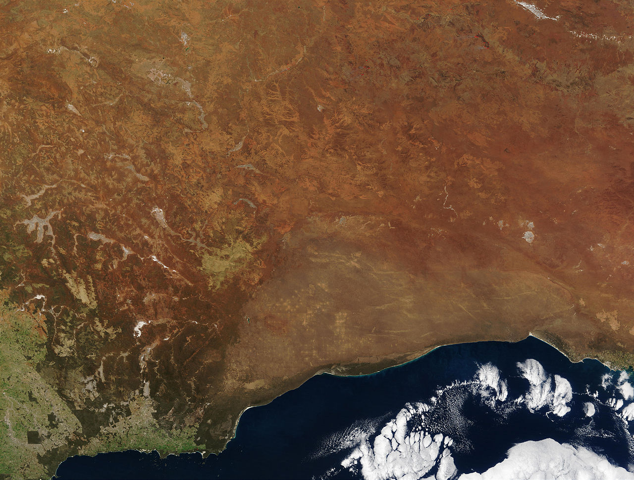


Geology and karst landscape
Underlain by a thick sequence of marine carbonate rock, the Nullarbor is one of the largest continuous exposures of limestone on Earth and displays classic karst features. Chemical weathering and dissolution of the carbonate bedrock over geological time have produced sinkholes, dolines and extensive cave systems. These subterranean networks are of scientific interest for their geology, hydrology and palaeontology, and they preserve records of past climates and life.
Climate, vegetation and wildlife
The climate across the plain is semi-arid to arid, with low and highly variable rainfall. Surface soils are typically shallow and calcareous; vegetation is therefore sparse and consists mainly of low shrubs, saltbush, native grasses and drought-tolerant herbs. The characteristic open aspect and scant tree cover give the region its name and wide horizons. Despite a seemingly austere environment, the Nullarbor supports native mammals (including various macropods), reptiles, invertebrates and a variety of seabirds along the coastal margin. Cave systems host specialised subterranean fauna adapted to dark, nutrient-limited conditions.
- Area: approximately 200,000 km².
- Extent: a long east–west stretch across southern Australia between state borders.
- Topography: a broad, flat limestone plateau with karstic sinkholes and caves.
- Coastline: dramatic cliffs where the plain meets the Great Australian Bight.
Human history, use and travel
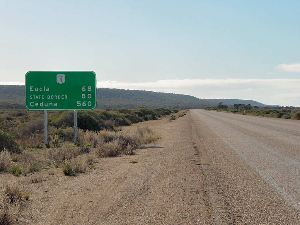
Indigenous Australians have occupied and used routes across the Nullarbor for thousands of years; the plain figures in the cultural landscapes and knowledge of local peoples. European contact from the 19th century brought exploration, pastoral activity where conditions allowed, and later transport development. Modern travellers cross the Nullarbor on major east–west routes such as the Eyre Highway and by rail, encountering long, straight stretches of road that emphasise the region's remoteness. Low rainfall and poor soils generally limit intensive farming.
Conservation, research and tourism
Portions of the plain and its coastal fringe are managed for conservation, scientific study and heritage. Researchers study the karst systems, fossil deposits and unique cave biota, while conservation efforts aim to protect remnant vegetation, wildlife habitats and culturally important places. Tourism is an important contemporary use: visitors come for road trips across the plain, guided cave tours, coastal wildlife watching and to experience the vast open landscape. Practical planning is essential for safe travel because settlements and services are widely spaced.
For introductory overviews and regional resources see general national and state sources on travel and geology (national resources), specialist summaries of carbonate and karst landscapes (limestone and karst references), material on the coastal environment of the Great Australian Bight, and state guides from South Australia and Western Australia. Notes on the name and early use of Latin terms are given in linguistic and historical discussions (etymology).
Questions and answers
Q: What is Nullarbor Plain?
A: Nullarbor Plain is an area of flat and dry land in southern Australia that holds the distinction of being the world's largest single piece of limestone.
Q: How big is Nullarbor Plain?
A: Nullarbor Plain occupies an area of around 200,000 square kilometers or 77,000 square miles.
Q: What does the name Nullarbor Plain mean?
A: The name Nullarbor comes from Latin words that mean "no trees".
Q: Where is Nullarbor Plain located?
A: Nullarbor Plain is located on the coastline of the Great Australian Bight and stretches about 1,100 kilometers from east to west between South Australia and Western Australia.
Q: What is the topography of Nullarbor Plain?
A: Nullarbor Plain is flat and dry, with no trees or other significant vegetation.
Q: What is the geological composition of Nullarbor Plain?
A: Nullarbor Plain is composed of limestone, which contributed to the formation of caves and sinkholes in the region.
Q: What is the significance of Nullarbor Plain?
A: As the world's largest single piece of limestone, Nullarbor Plain is an important geological site with unique formations and landscapes. It is also home to a variety of wildlife, including kangaroos and emus.
Related articles
Author
AlegsaOnline.com Nullarbor Plain — the treeless limestone expanse of southern Australia Leandro Alegsa
URL: https://en.alegsaonline.com/art/71415