North Indian Plain (Gangetic Plain)
A broad, fertile lowland formed by the Ganges and its tributaries across northern India, Nepal and Bangladesh; one of the world’s most densely populated and agriculturally productive regions.
Overview
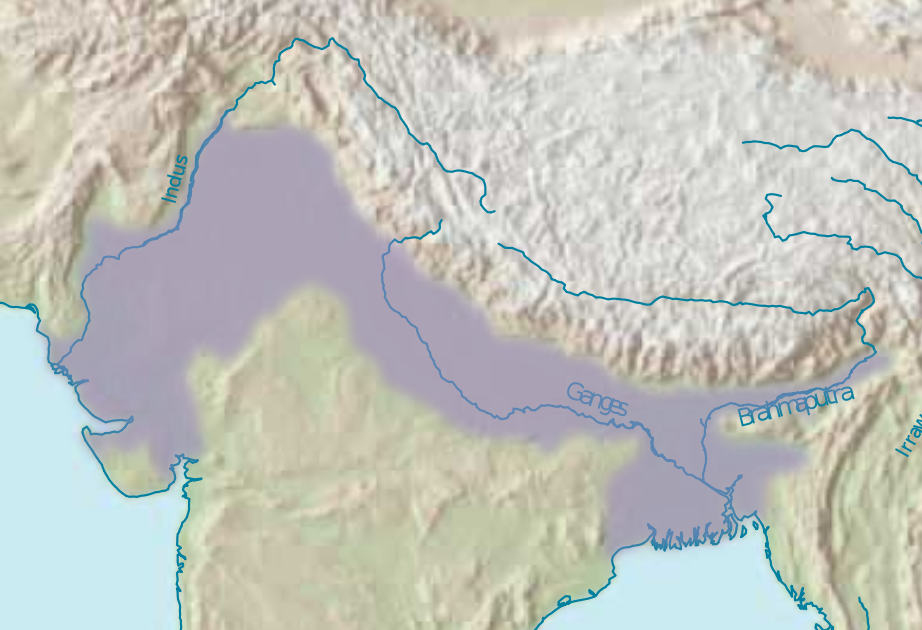
The North Indian Plain, commonly called the Gangetic Plain, is an extensive swath of flat land created by river deposits from the Ganges and its tributary network. It spans portions of India, Nepal and Bangladesh. The plain is typically illustrated on regional maps and geographic summaries (see map) because of its large area and dense population. Modern estimates place the population of the plain in the hundreds of millions, making it one of the most populous continuous lowland regions on Earth (population data; roughly one in seven people live within the broader basin of the Ganges and adjoining plains).
Image gallery
8 Images


Geography and boundaries
Physically the plain is bounded by distinct natural features: the Thar Desert marks its western limit (Thar Desert), the Himalaya foothills sit to the north and feed rivers and alluvium into the basin (Himalayas), and toward the east the plain descends into the large tidal delta formed by the Ganges and Brahmaputra (Ganges Delta), often described as the world's largest river delta in comparative accounts (delta scale). To the south the uplands of the Vindhya and Satpura ranges and the Chota Nagpur Plateau separate the plain from peninsular India (southern boundary).
Soils, water and climate
The plain is dominated by alluvial soils deposited by successive floods and river channels. These sediments produce deep, fertile loams and silts that support intensive agriculture. Seasonal monsoon rains combined with snowmelt from the mountains determine river flows; irrigation schemes, canals and groundwater are heavily used to stabilize cropping through dry months. Climatic zones vary from semi-arid in the west to humid subtropical and tropical wet in the east, which influences crop patterns and settlement density.
Human history and cultural importance
The Gangetic Plain has been a focal point for human settlement for millennia and is frequently cited as a regional cradle of civilization, where early urban centers, religious traditions, and complex societies developed. Rivers provided transport, fertile fields and access to resources, encouraging the rise of cities and states across different historical periods. Archaeological and historical records show dense networks of towns, pilgrimage routes and cultural exchange centered on river corridors.
Economy, agriculture and examples
Agriculture is the dominant land use: staples such as rice, wheat, sugarcane and oilseeds are grown extensively. Irrigated rice is prevalent in humid eastern areas; wheat and cash crops are more common in the drier west. Major cities within the plain serve as manufacturing, administrative and market centers that process agricultural goods and support service economies. Typical features include terraced cropping in some river valleys, large irrigation projects, and seasonal migration of labor between rural and urban areas.
Distinctive features and contemporary challenges
- Hydrology: complex braided rivers and shifting channels mean flood control and river management are ongoing tasks.
- Population pressure: high density produces intense demands for land, water and infrastructure.
- Environmental concerns: groundwater depletion, soil degradation and pollution affect productivity and health.
- Strategic importance: the plain links high mountain sources to a major delta and supports national food security for multiple countries.
For regional overviews, physical maps and demographic summaries consult authoritative sources and regional surveys (map resource, population overview). Further reading on the plain's boundaries and hydrology may be found through summaries of the Himalaya-fed river system (mountain sources) and deltaic processes (delta studies, comparative delta).
Helpful country-specific resources consider administrative, agricultural and environmental policies in India, Nepal and Bangladesh. Historical perspectives on early urbanization and cultural development are discussed in works that treat the region as a cradle of civilization, while geographic boundaries like the Thar, Himalaya and Vindhya–Satpura uplands remain central to understanding its extent.
Questions and answers
Q: What is the Gangetic Plains?
A: The Gangetic Plains is a large space of level land that is made by the Ganges River in the northern parts of India and the border surrounding areas of the Himalayas.
Q: Which countries does the Gangetic Plains belong to?
A: The Gangetic Plains is an important part of the countries of India, Nepal, and Bangladesh.
Q: What is the size of the Gangetic Plains?
A: The space of the Gangetic Plains is about 700,000 square kilometers or 270,000 square miles.
Q: How many people live in the Gangetic Plains?
A: The home of about one billion persons, about one in every seven persons alive today, is in the Gangetic Plains.
Q: What are the geographical borders of the Gangetic Plains?
A: The western edge of the Gangetic Plains is the Thar Desert; its northern edge is the Himalaya Mountains, the highest mountains on Earth; its eastern edge is the Ganges Delta of Bangladesh, the largest River delta in the world; and its southern edge is made by the Vindhya Mountains and Satpura Range and Chota Nagpur Plateau of middle India.
Q: Why is the Gangetic Plains an important area?
A: The area has fertile land for agriculture, adequate water supply, and favorable climate. It is also known as a Cradle of civilization.
Q: What is the Cradle of civilization?
A: The Cradle of civilization is a term used to describe regions where civilization is believed to have originated. The Gangetic Plains is one such region.
Related articles
Author
AlegsaOnline.com North Indian Plain (Gangetic Plain) Leandro Alegsa
URL: https://en.alegsaonline.com/art/70885