Nile River — geography, history, ecology and modern management
Comprehensive overview of the Nile: its course and tributaries, role in ancient and modern societies, ecology, the Aswan works, and contemporary water management issues.
Overview
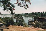
The Nile is the longest river system in Africa and is widely regarded as the longest river in the world. It flows northward from interior East Africa to the Mediterranean Sea, providing water, fertile soil and transport across a large, predominantly arid region. The river's basin supports millions of people and a wide range of plants and animals, and it has played a defining role in the development of ancient and modern civilizations along its banks.
Image gallery
10 Images


Course and main tributaries
The Nile's course is formed by major tributaries that arise in different parts of East Africa. The White Nile rises near the African Great Lakes region and is commonly traced to Lake Victoria, while the Blue Nile originates in the highlands of Ethiopia before descending toward the Sudan. These branches converge around Khartoum to create the river that continues through Sudan and Egypt to the Mediterranean near Alexandria. Along its route the Nile passes through or beside several countries and is linked to many lakes, dams and irrigation works that shape its flow.
Historical importance and human use
For millennia the Nile's seasonal flooding deposited nutrient-rich silt on floodplains and enabled productive agriculture in otherwise desert regions. Ancient Egyptian civilization depended on predictable inundation cycles to cultivate cereals and vegetables, and communities harvested papyrus from the river's marshes for material and writing. Cities, trade routes and monumental architecture developed beside the river because it provided transport, food and stone-moving capacity — large blocks quarried near Aswan were shipped by barge along the Nile for building projects.
Ecology and economic value
The Nile basin supports diverse wildlife: freshwater fish species, waterfowl, hippos and crocodiles are among the most familiar. Wetlands and riverine forests shelter migratory birds and endemic species. Today the river remains central to agriculture, drinking water, industry and transport in the countries it traverses. Irrigation networks draw on Nile water to grow food, while river traffic still conveys goods and people between towns and rural areas.
Modern management, engineering and challenges
In the 20th century large engineering works changed the Nile's natural rhythms. The construction of the Aswan High Dam created a major reservoir that controls flooding, allows regulated irrigation and generates hydroelectric power, but also reduced annual silt deposition downstream and altered coastal sediment budgets. Competing demands for water, population growth and development projects have prompted international negotiations among Nile basin states about allocations, dam projects and sustainable management. These discussions balance national development goals with ecological concerns and the needs of downstream users.
Notable facts and distinctions
- Length and rank: The Nile is often described as the world's longest river, a title checked against other long rivers by different measurement methods.
- Confluence: The meeting of the White and Blue Nile is a prominent geographic landmark near Khartoum.
- Archaeology: Many archaeological sites and cultural heritage locations are concentrated along the Nile's fertile corridor.
Further reading and resources
The following links provide gateways to more detailed information on geography, history, ecology and modern issues related to the Nile basin:
- General overview and maps
- Regional context in Africa
- Comparisons of river lengths
- Lake Victoria and headwaters
- Mouth and Mediterranean connection
- Alexandria and the Nile delta
- Etymology and historical names
- Uganda and upstream regions
- Sudan and Nile management
- Khartoum and the confluence
- Egypt's reliance on the Nile
- Ethiopia and the Blue Nile's source
- Relative location to the Red Sea
- Hydrology and flow measurements
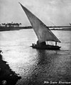
- River transport and navigation
- Historical transport routes
- Urban settlements along the Nile
- Pyramids, monuments and nearby sites
- Agricultural use of Nile water
- Surrounding desert environments
- Ancient Egyptian civilization
- Papyrus and early writing materials
- Fauna of the Nile basin
- Crocodiles and large reptiles
- Birdlife and wetlands
- Fish species and fisheries
- Everyday uses of Nile water
- Quarries at Aswan and stone transport
Geography
Source
The Nile has two headwaters: the shorter but more water-rich Blue Nile and the much longer White Nile. The latter forms the main axis of the catchment area, which at around 3,255,000 km² is only slightly smaller than that of the Congo (3,731,000 km²).
Blue Nile
→ Main article: Blue Nile
The Blue Nile drains large parts of the highlands of Abyssinia, which are rich in rainfall. Its headwaters collect in the great Lake Tana. Soon after leaving the lake, the Blue Nile forms the Tis Issat waterfall and flows through long cañons up to 1,500 m deep. Due to international restrictions, it could only be used to a limited extent in Ethiopia for a long time. In the meantime, the Grand Ethiopian Renaissance Dam is under construction, which will at least be able to influence the water flow of the Blue Nile. In Sudan, the Blue Nile is dammed by the Roseires Dam and the Sennar Dam for irrigation mainly of the Gezira Project and for power generation. After running for 1,783 km, it joins the White Nile at Khartoum, where the average flow is about a quarter less.
The Blue Nile is rich in sediment and was therefore formerly the main supplier of the Nile alluvium, which is important for the deposition of fertile Nile mud in Egypt, but has lost its importance at the latest since the construction of the Aswan Dam. It took place, depending on the course of the rainy season in the Ethiopian highlands, in the months of July to October. During this time, the Blue Nile carries an average of five times as much water as the White Nile, which has a much more even flow. Conversely, in the average of the remaining eight months, the White Nile carries almost 1.8 times as much water as the Blue Nile.
White Nile
→ Main article: White Nile
The White Nile is usually regarded as the actual Nile, despite its lower water flow. Compared to the Blue Nile, it has a catchment area that is more than five times as large and, at around 3800 kilometres, more than 2.5 times as long.
The White Nile originates in the high hill countries of Burundi, Rwanda and Tanzania from the Burundian headwaters Luvironza-Ruvuvu and the Rwandan headwaters Rukarara-Nyabarongo, which flow into the Kagera (in the upper reaches also Akagera).
→ Main article: Kagera Nile
The Kagera River, which reaches the western shore of Lake Victoria in northern Tanzania, is its largest tributary. It has a catchment area of about 60,000 km² and drains most of Rwanda, half of Burundi and small parts of northwestern Tanzania. In the past, the Kagera was often not considered part of the Nile, despite its total length of well over 900 kilometres and a flow rate of over 230 m³/s.
The Victoria Nile leaves Lake Victoria in the north in Uganda. Just below the former Owen Falls and Ripon Falls, it is dammed so high that the lake level of Lake Victoria can also be raised by up to three metres. Below Bujagali Rapids and Lake Kyoga, it is called the Kyoga Nile, flowing into Lake Albert via Karuma Falls and Murchison Falls. As Albert Nile, it flows out of the lake to the border with South Sudan. From there, the river's course is called Bahr al-Jabal (Arabic: mountain river; also Bahr al-Jabal, Bahr el-Jabal). At the town of Juba, it leaves the highlands and enters the Sudd marshes at the town of Bur, stretching almost 400 kilometres to the north. Here, 51 percent of the Nile's water evaporates, with the water flow decreasing from 1048 m³/s to 510 m³/s.
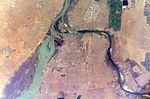
Shortly before leaving the Sudd, the Bahr al-Jabal meets the long but water-scarce river Bahr al-Ghazāl (2 m³/s) coming from the left in Lake No and from there on is called the Bahr al-Abiad (White Nile), which now initially flows eastwards. At the town of Malakal, the unfinished Jonglei Canal and the powerful, clay-coloured Sobat (412 m³/s) join it on the right. It then continues northwards towards Khartoum and Omdurman, where it meets the Blue Nile, which comes from Ethiopia on the right (southeast).
· 
Dominance of the White Nile (below) over the Blue Nile (right) in the dry season (April).
· 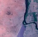
Dominance of the Blue Nile over the back-dammed White Nile during the rainy season (August)
· 
Nile near Khartoum, around 1910
· 
Confluence of the White and Blue Nile, 2010
From Khartoum to Cairo
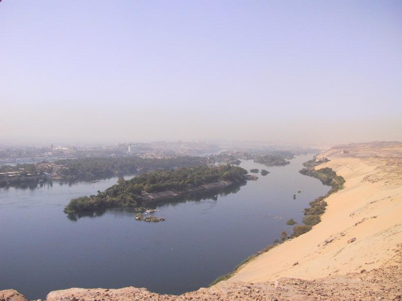
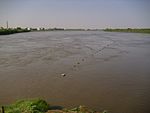
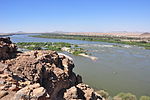
From Khartoum downstream, the Nile flows as a so-called foreigner river through extensive desert landscapes S-shaped further to the north enclosing the Bayuda Desert. In the west begins the Libyan Desert, eastward to the Red Sea lies the Nubian Desert, which in Egypt is called the Arabian Desert. In the northern Sudanese and Egyptian desert areas, the Nile forms a depression 5 to 20 kilometers wide; it is a vital river oasis and the agricultural base of Egypt. The calm and wide course of the Nile is disturbed by narrows and rocks in the six cataracts, but three of these have now disappeared into reservoirs.
The Atbara, a sediment-rich mountain river from the Ethiopian highlands, flows into the Nile about 300 km below Khartoum. During the three-month flood period, it supplies a considerable amount of water to the Nile, but in the dry season it almost completely dries up. It is the last tributary of the Nile before it flows into the Mediterranean.
The fourth cataract about 400 kilometres north of Khartoum was flooded by the new Merowe reservoir, which reached full damming in 2009. At Al Dabba at the southern end of the Nile Arc, the Wadi Howar, the former Yellow Nile, which no longer carries water, flows in from the west.
Shortly before Wadi Halfa, the Nile reaches Lake Nubia, the section of Lake Nasser located in Sudan, which is dammed by the Aswan Dam built from 1960 to 1971. In the Egyptian part of the reservoir, north of Abu Simbel, there is a large pumping station that supplies water to the Toshka project.
Along the nearly 1000 km stretch from the Aswan Dam to Cairo, the Nile has become a huge irrigation canal since Muhammad Ali Pasha (1805-1848 Viceroy of Egypt) had the Delta Barrages built and began to change irrigation methods on the Nile from the seasonal irrigation in flood basins practiced since the Pharaohs to year-round canal irrigation. The Ibrahimiyya Canal, completed in 1873 and some 350 km long, also serving the Fayyum Basin in the west of the Nile via the Bahr Yusuf Canal, was the next major measure. Beginning with the old Aswan Dam, the Asyut Dam and the Zifta Dam, a series of dams and thousands of kilometers of canals have been built since the beginning of the 20th century, supplying water in a largely uniform manner. Even after the Aswan Dam, further dams were and are being built: cf. the list of dams on the Nile.
· 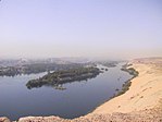
Nile near Aswan 2002
· 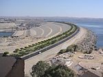
Aswan Dam
· 
Nile at El-Minija
· 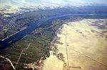
Nile River Oasis near Luxor
Delta
Below Cairo, the Nile fans out to form the Nile Delta, which covers an area of about 24,000 km² and flows into the Mediterranean Sea in two main branches. Since the construction of the Aswan Dam in the 1960s and the resulting absence of the Nile flood, the river delta no longer grows further into the sea, but is partly eroded by the surf. Only the left one, the Rosetta branch, still reaches the sea continuously; the Damietta branch is dammed off just before its mouth, so that its water often only reaches the open sea via irrigation canals. The main reasons for the reduction of the Nile's discharge are considered to be the more intensive irrigation of significantly enlarged agricultural areas and the evaporation losses over Lake Nasser.
Tributaries
| Left (here western) tributaries:
| Right (here eastern) tributaries:
|
Cataracts and waterfalls
White Nile
The upper course of the White Nile runs through tectonically unstable terrain and has been subject to many changes in the recent geological past. This is reflected in the unbalanced longitudinal profile of the river with numerous smaller and larger waterfalls and rapids. These include:
- Rusumo Falls on the border of Rwanda and Tanzania
- Kuruma Rapids in Tanzania - east of the north knee of Kagera
- Ripon Falls in Uganda - (flooded by the Owen Falls Dam from Lake Victoria)
- Owen Falls in Uganda - (flooded by the Owen Falls Dam from Lake Victoria)
- Bujagali Falls in Uganda - below the Owen Falls Dam (flood dam under construction)
- Karuma Falls in Uganda - about 60 km above Murchison Falls
- Murchison Falls (also called Kabelega Falls) in Uganda
Blue Nile
The Blue Nile flows through plateau landscapes with multiple horizontal layers, in whose deeply cut valleys it forms numerous rapids. The only large waterfall is probably the most famous in the Nile river system, the Tis Issat.
cataracts in midstream
In the middle reaches of the Nile, below the confluence of the Blue Nile and White Nile, the riverbed is characterized by six natural granite barriers that are much harder than the surrounding sedimentary rock and the Nile sediments. In ancient Egypt, the dreaded cataracts formed the boundaries between kingdoms. Although some of them have since been dammed over, they remain obstacles to navigation to this day, at low water because of hidden cliffs and obscure narrow rocky channels, and at high water because of the rushing current.
Since ancient times, the cataracts were simply numbered upstream (i.e. from north to south). The first cataract is in what is now Egypt; the second through sixth cataracts are in Sudan.
- The first cataract is at Aswan (24° 5′ 0.4″ N, 32° 52′ 54.3″ E24.08345532.881737), the only one in present-day Egypt. A large part of it was flooded by the construction of the old Aswan Dam.
- The second cataract (or Great Cataract) is located in Nubia above the Nasser Reservoir (21° 28′ 46.5″ N, 30° 57′ 41.5″ E21.47958830.961533).
- The third cataract is located near Tombos/Hannek (19° 48′ 41.2″ N, 30° 18′ 38.9″ E19.81144630.310807).
- The fourth cataract is located at Dar al-Manasir and has been flooded by the Merowe Dam since 2008 (18° 59′ 44.1″ N, 32° 23′ 55.3″ E18.99558332.398682).
- The fifth cataract is located at the confluence of the Nile and Atbara Rivers (18° 24′ 43.9″ N, 33° 45′ 43.9″ E18.41219333.762188).
- The sixth cataract is located at a mountain break, the Sabaluka intrusion, near Meroe (16° 20′ 59.7″ N, 32° 42′ 26.2″ E16.34991532.707286).
Location of the six cataracts (f1![]() map with all coordinates of the section cataracts at the middle reaches: OSM ).
map with all coordinates of the section cataracts at the middle reaches: OSM ).
· 
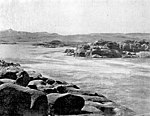
1. cataract around 1870
· 
1. cataract, date unknown
· 
3. cataract 2010
· 
Expiry of the 4th cataract 2010
· 
6. cataract around 1908
Cities on the banks of the Nile
Cairo, Giza (both Egypt) and Khartoum (Sudan) are the largest cities.
The ancient Egyptians often built their cities on the fertile plains of the sacred river. Many cataracts and dams were built, among other things, for settlement.
- Rwanda
- Uganda
- Kampala (on Lake Victoria)
- Jinja
- South Sudan
- Juba
- Malakal
- Sudan
- Kusti
- Rabak
- Khartoum (al-Chartūm).
- Omdurman (Umm Durmān).
- al-Chartum Bahri
- Atbara
- Wadi Halfa
- Egypt
- Places in or near the Nile Delta
- Cairo (al-Qāhira)
- Giza (al-Jīza)
- Heliopolis (Misr al-Jadīda)
- Imbaba (Imbābā).
- Banha (Banhā)
- Shibin al-Kaum
- Ismailia (al-Isma'īliyya, on the Suez Canal, connected to the Nile Delta via a side canal)
- Zagazig (az-Zaqāzīq)
- Tanta (Tantā)
- Mahalla al-Kubra (al-Mahallāt al-Kubrā)
- Mansura (al-Mansura)
- Naukratis (Nebireh)
- Damanhur (Damanhūr)
- Kafr ash-Shaikh
- Alexandria (al-Iskandariyya)
- Port Said (Būr Sa'īd)
- Damietta (Dumyāt)


Fauna
The Nile is inhabited by over 120 species of fish, which is not many for a river of this length. Endemic are about a quarter of the species, there is no endemic genus. The Nile Valley does not form a zoogeographical unit; about 75 species also occur in the Niger River basin and most of these species also occur in other West African rivers. Over 20 fish species living in the Nile are also found in the Congo Basin. Large fish species living in the Nile include the plankton-feeding African bony tongues (Heterotis niloticus) and the predatory fishes Greater Nile pike (Gymnarchus niloticus) and Nile perch (Lates niloticus). The tremor catfishes are represented by two species, Malapterurus electricus and Malapterurus minjiriya. The most species-rich fish family is the carp fish (Cyprinidae) with 18 species and the Nile pike (Mormyridae) with 16 species.
Many other animal species were named after the river, such as the Nile crocodile, the Nile goose, the Nile grass rat, the Nile monitor and also the Nile or hippopotamus, which, however, no longer occurs in the lower reaches. Many animals served the Egyptians as pets or are models for gods.

Questions and answers
Q: What is the longest river on Earth?
A: The Nile is the longest river on Earth, measuring about 6,650 km or 4,132 miles.
Q: Where does the Nile get its name from?
A: The Nile gets its name from the Greek word "Νεῖλος" (Neil's).
Q: How much water flows down the Nile each day?
A: About 300 million cubic metres of water flow down the Nile each day.
Q: Why are cities and pyramids built near the Nile in Egypt?
A: Cities and pyramids are built near the Nile in Egypt because it provides most of their water used to grow crops and it is an easy way to transport goods by boat.
Q: What did Ancient Egyptians use papyrus for?
A: Ancient Egyptians used papyrus from plants that grew near the Nile to write on.
Q: What types of animals live in or near the waters of the Nile?
A: Many different types of animals live in or near the waters of the Nile, including crocodiles, birds, fish and many others.
Q: Why were pyramids built close to the Nile?
A: Pyramids were built close to the Nile because they needed granite stones from Aswan which could be transported by barges downriver.
Related articles
Author
AlegsaOnline.com Nile River — geography, history, ecology and modern management Leandro Alegsa
URL: https://en.alegsaonline.com/art/70215
Sources
- Nile
- glyphdoctors.com : What did the ancient Egyptians call the Nile river?