Niger
![]()
The title of this article is ambiguous. For other meanings, see Niger (disambiguation).
Template:Infobox State/Maintenance/NAME-German
Niger (German [ˈniːgɐ], French [![]()
![]() niˈʒɛːʁ]), officially the Republic of Niger, is a landlocked country in West Africa. The namesake Niger River flows through the relatively densely populated southwest of the desert and savannah state.
niˈʒɛːʁ]), officially the Republic of Niger, is a landlocked country in West Africa. The namesake Niger River flows through the relatively densely populated southwest of the desert and savannah state.
Niger is bordered by Algeria and Libya to the north, Mali and Burkina Faso to the west, Chad to the east, and Nigeria and Benin to the south. It is a landlocked country with a share of the Sahara, Sahel and Sudan. The population of about 23.3 million is growing rapidly through births, and the fertility rate of 6.93 is the highest in the world. Niger's largest city is the capital Niamey. Other major cities are Zinder, Maradi and Agadez.
The former French colony has been independent since 1960. After a period of coups d'état and Tuareg uprisings, Niger seems to be stabilising politically. Threatening the existence of most of the Nigerien population are regularly recurring droughts and famines with a population growing too fast due to a lack of birth control. Niger is among the poorest countries in the world and ranked last out of 189 countries evaluated in the 2019 Human Development Index.
Geography
In the centre of Niger lies the Aïr Mountains, whose highest peak, Idoukal-n-Taghès, at 2022 m, is also the highest point in the country. The Aïr Mountains (Massif Aïr) are the southeastern continuation of the Algerian Hoggar or Ahaggar Mountains and form the geographical border with the Chad Basin. To the southeast of the Aïr lies the Termit massif. From its southern foothills stretches the almost 200 km long valley of the Dilia de Lagané, at the southern end of which the foothills of Lake Mega Chad are still visible.
To the west, south and east, the Aïr is surrounded by deserts, the largest of which is the Erg du Ténéré to the east. It occupies about 30% of the national territory, which is densely populated only at the southwestern edge. Further east lies the Grand Erg de Bilma with the Kaouar valley. These Saharan regions extend eastward to the border of Chad. To the north, the Ténéré merges into the Djado plateau, and to the northeast into the Tibesti Mountains. These deserts, all of which belong to the Sahara, occupy a total of about two-thirds of the national territory. Large parts of the Ténéré and the Aïr belong to the 77,000 km² Aïr and Ténéré Nature Reserve, a UNESCO World Heritage Site. In the south of the Aïr mountains lies the important fossil site of Gadoufaoua from the Lower Cretaceous period (Albium-Aptian, 126.3 to 100.5 mya). Because of the numerous dinosaur remains, for example Nigersaurus or Ouranosaurus nigeriensis, the area is considered a "dinosaur graveyard" of the Sahara.
About one third of Niger in the south and southeast is part of the Sahel (Sahel = Arab. "shore" of the desert). This strip is located on the northern edge of the dry savannah. Since the late sixties, several droughts have occurred in the thornbush savannah, increasingly transforming it into a desert-like landscape. In the southeast, part of Lake Chad lies on Niger's territory, but its extent retreats behind the border with Chad during severe drought.
The southwest is dominated by the Niger, Africa's third largest river. As a foreign river, it flows for 650 kilometres through a particularly fertile region of the country and forms the border with Benin in the lower part before leaving the country in the south at an altitude of just under 200 metres to Nigeria.
In 1954, the transnational National Park W was designated as the only national park in Niger.
Climate
Niger's climate is consistently hot and dry. In the south of the country, the West African monsoon brings a rainy season that lasts from June to October. During this time, almost all of the year's precipitation falls, averaging between 400 and 700 millimeters. About half of the rainfall can be expected in August. In the northern parts of the country (desert areas) there is practically no rainfall recently.
Daytime temperatures in the desert areas average 17 °C in January and 34 °C in June. In the south, temperatures range from 22 to 24 °C in January and 32 to 34 °C in June.
According to the dry climate, the dry savannah changes from south to north into briar savannah and soon into semi-desert and full desert. In the north, large areas are sand and stone desert. As a result of the five-year drought between 1969 and 1974 in the entire Sahel, the groundwater table has dropped, the natural vegetation has partly died completely, and some of it has been destroyed by livestock. This in turn reduced livestock numbers and cost human lives. The area that can only be used by nomads has consequently extended about 50 km further south.
Hydrology
The state of Niger drains through two catchments; that of the Niger River and that of Lake Chad. However, Niger State contributes little to either catchment. In much of the country, rainfall is less than 200 mm. Many riverbeds carry water for only a short time, if at all, during the year and usually do not reach either Lake Chad or the Niger.
The largest drainage basin is that of the Azawagh, with the Dallol Bosso as its estuary. It extends as a system of wadis across the Aïr, the Ahaggar in Algeria and the Adrar of the Ifoghas Mountains in Mali as a border and drained the Ullemmeden basin in more humid times.
| Catchment area | Square kilometer | Percentage of the country |
| Niger | 563.939 | 44,5 |
| Lake Chad | 703.061 | 55,5 |
| Total | 1.267.000 | 100 |
See also: List of rivers in Niger
Flora
In the south, the dry savannah is dominated by native grasses, thorn bushes and dry forest. In the lower lying region, tamarinds, baobabs, kapok trees and mahogany grow. Due to overgrazing and drought, the savanna's plant population has suffered greatly in recent years. The areas of the north are practically devoid of vegetation.
Fauna
The fauna of large parts of the country is not very rich in species, due to the sparse and growing desert vegetation. The desert regions dominate the entire north of the country. Fenneks and gazelles live here, while baboons and Aïr maned jumpers, among others, can be found in the mountains of the Aïr. At the same time, the Aïr is home to one of the largest protected areas in the world, the Aïr and Ténéré Nature Reserve. The southern parts of the country, where savannahs naturally predominate, are naturally richer in species. However, as in the whole of West Africa, the large animal world is now limited to relict occurrences. In the southwest of Niger lies the W National Park, which together with the adjacent Pendjari National Park in Benin and the Arli National Park in Burkina Faso forms one of the most important large animal conservation areas in the whole of West Africa. Lions, antelopes, giraffes, buffaloes, ostriches, elephants and hippos are still found here.
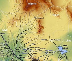
The watercourses in Niger
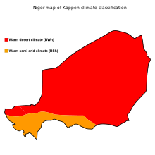
The climatic zones in Niger
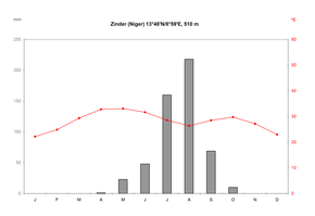
Climate diagram of Zinder in Niger; the temperature curve is the red line, the bars show the precipitation.
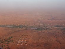
Landscape in the southwest of Niger
Population
Since independence in 1960, Niger's population has grown from 3.2 to 23.3 million people, more than a sevenfold increase. The government is taking little action to curb the population explosion or to make the country more arable. The UN predicts that the population will continue to grow, reaching about 66 million in 2050 and 165 million in 2100.
The fertility rate is the highest in the world at 6.92 births per woman (2018), leading to an annual population growth of 3.8%. Since 1983, when the fertility rate peaked at 7.89, it has been slowly declining. The proportion of the population under 15 years of age was 49.8% in 2012. Niger had the youngest median age of all countries at 15.2 years.
Most brides in Niger are under the age of consent when they marry - according to a 2012 study by Niger's Ministry of Public Health, 75% of girls are only between 15 and 19 years old when they are married. In a 2011 report by the United Nations Children's Fund, this ranked Niger number one on the list of countries where child marriage is most prevalent.
There are many oasis dwellers, nomads and semi-nomads, especially in the north of the country. However, many of them give up nomadism and move to the partly overpopulated cities. The majority of the population lives in the south, mostly on the border with Nigeria and Benin.
Peoples
The Zarma and Songhai ethnic groups, which are politically dominant in the Niger region, account for about 21 % of the total population. About 55.4 % belong to the Hausa majority. The Hausa inhabit the central south on the border with Nigeria. Already during the French colonial period, the Songhai and Zarma were mostly favoured in the allocation of key political positions to Nigrians. This disproportionality in terms of representation in the population continued during the period of the independent republic. Niger's first three presidents were all Zarma, and in 1993 a Hausa, Mahamane Ousmane, was elected president for the first time. In 2021, Mohamed Bazoum, a citizen from the Arab minority in Niger (Diffa Arabs), was elected president for the first time.
Around 9.3 % of the population belong to the Tuareg Berbers, who live as nomads or sedentary oasis dwellers in the semi-desert and desert. They mainly inhabit the Agadez region in the north of the country. About 4.7% are the Beri Beri (Kanuri), as they are called in Niger. The Fulbe ethnic group lives sedentary or as pastoral nomads, with 8.5% of the population in the Sahel. There are also over 3000 French people living in the country, mostly in urban areas. In 2017, 1.4% of the population was foreign born. Most foreigners come from Nigeria and Mali and are often refugees.
There is a Nigerien diaspora living mainly in France and Nigeria.
Languages
→ Main article: Languages of Niger
The official language is French. In addition, there are ten recognised national languages. Of these, the two languages Hausa (spoken by about 56 % of the population as a first language and understood by about 85 %) and Songhai-Zarma with about 20 % have the highest number of speakers. Other national languages are Tamascheq (about 8%), Fulfulde (about 8%), Kanuri (about 5%), Arabic (about 1%), Buduma, Gourmanchéma, Tasawaq and Tubu. Arabic is spoken by 3% of the population and is additionally used throughout the country for Islamic religious education. English or German are not widely spoken.
Religion
The vast majority of Nigeriens profess Islam (95% in 2007) - almost all of them Sunnis from the Malikite school of law - while the rest of the population is divided between Christians and followers of traditional African religions.
See also: History of Islam among the Tuareg
Health
Large parts of the population are denied access to health services because treatments have to be paid for in advance, which many people cannot afford. Medicines also have to be financed by the patients themselves. For inpatient treatment, relatives often have to provide the patient with food. There is a health insurance scheme, but only a few employees and civil servants are insured.
Access is also hampered by the fact that there are too few doctors. According to a WHO report, there are 42 hospitals, almost 600 health centres and a good 1000 medical wards, but there is usually a lack of equipment, medicines and (qualified) staff. Statistically, there are about 9000 people per doctor; the WHO recommends a maximum of 600 patients per doctor. In 2004, the number of doctors in Niger was less than 400. In addition to the state-run facilities, there are private hospitals, medical wards or doctors in private practice with outpatient clinics - some of them under European management.
The population of Niger is threatened by multiple diseases such as: Yellow fever, tuberculosis, leprosy, typhoid, noma, brucellosis, hepatitis, schistosomiasis and HIV/AIDS. The three main causes of death (about 40% of deaths) are: Influenza/Pneumonia, Malaria and diarrheal diseases such as Cholera; but traffic accidents also fall into this category. During the hot season (March to the beginning of the rainy season in July), the country regularly suffers from violent, sometimes almost epidemic outbreaks of meningitis.
The health situation of mothers and children in Niger is poor. Malnutrition, malnutrition and undernourishment are not uncommon, partly due to the sharp increase in population and recurrent droughts. Infant mortality is high at 47 per 1000 live births, as is child mortality at 80 per 1000 live births.
The average life expectancy at birth is 62.4 years according to HDI, and 63.3 years according to WHO. Access to safe drinking water, a UN human right since 2010, was available to only one in two people in Niger in 2017, according to WHO, with wide disparities between urban (84%) and rural (44%) areas. In 2000, only about a third of the population had access.
Compared to other countries in Africa, the prevalence of AIDS in Niger is low. In 2019, 0.3% of the population was infected with HIV.
See also: COVID-19 pandemic in Niger
| Development of life expectancy in Niger | |||
| Period | Life expectancy | Period | Life expectancy |
| 1950–1955 | 35 | 1985–1990 | 42 |
| 1955–1960 | 35 | 1990–1995 | 45 |
| 1960–1965 | 35 | 1995–2000 | 48 |
| 1965–1970 | 36 | 2000–2005 | 51 |
| 1970–1975 | 36 | 2005–2010 | 55 |
| 1975–1980 | 38 | 2010–2015 | 59 |
| 1980–1985 | 40 | 2015–2020 | 62 |
Education
69.4% of Nigerians are illiterate, giving the country the lowest literacy rates in the world. In Niger, although the median length of schooling for people over 25 increased from 0.7 years in 1990 to 2.1 in 2019, this figure places Niger second to last in the world (ahead of Burkina Faso at 1.6 years). The expected length of schooling for the current generation of students is 6.5 years in 2019, again placing Niger second to last (ahead of South Sudan at 5.3 years). On average, girls receive less schooling at 5.7 years than boys at 7.2 years. Child labour is accordingly widespread.
The country has universities, including the Abdou Moumouni University of Niamey.
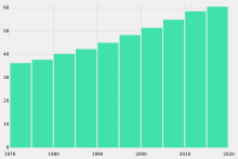
Development of life expectancy .
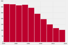
Trends in infant mortality (deaths per 1000 births)
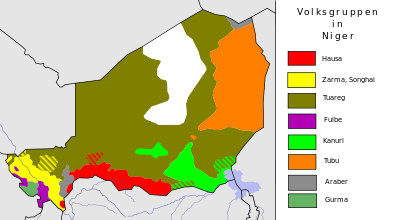
Settlement areas of the ethnic groups
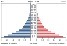
Niger has the youngest population in the world
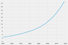
Population development in millions of inhabitants
Search within the encyclopedia