New York Harbor
The Port of New York (New York Harbor or Port of New York and New Jersey), located on the east coast of the United States, includes the entirety of the seven major port facilities currently in use and several historic port facilities and the entirety of the natural harbor at the mouth of the Hudson River on the Atlantic Ocean (Tidal Harbor). It also includes two free trade zones. Thus, the term geographically describes a region and is not a single institution, nor is it limited to the New York metropolitan area (more accurate would be: a plurality of institutions). However, the term "New York Harbor" is often used in everyday language only for the facilities of the joint authority of the two U.S. neighboring states, the Port Authority of New York and New Jersey (PANYNJ). However, this interstate authority does not have jurisdiction over all aspects affecting the harbor area. Today, the largest cities at the mouth of the Hudson River are New York City, Jersey City and Newark.
By cargo throughput, it is the third largest port in the United States as a whole - but the largest by area. It serves both as an international deepwater port and, via the Hudson, as an inland port for parts of the northeastern United States and eastern Canada.
New York's economic importance today is related to its use for East Coast goods handling and passenger transportation. The completion of the Erie Canal in 1825 opened up a convenient transportation route to the Great Lakes, and New York rose to become the most important commercial port on the East Coast. In addition, the city was and still is a major point of immigration to the United States. Millions of immigrants came here on ships and passed through its facilities, of which Ellis Island is a relatively recent one. After immigration, which used to be more significant, tourism now dominates passenger shipping in New York Harbor.
Entering New York from Lower New York Bay, one crosses the Narrows under the Verrazzano-Narrows Bridge (1964) into the main basin of Upper New York Bay with New York's two most famous islands (after Manhattan itself; Ellis and Liberty Island with the Statue of Liberty) to the various anchorages. Historically, access to the waters has been known to be dangerous for a variety of reasons. Most notably, the fog and storm surges that run up into the nearly right-angled funnel of the Lower Bay, depending on wind direction, are feared. Hudson Canyon, a pre-glacial submarine delta that runs centrally out into the bay, is considered a ship graveyard. To the northwest, Long Island Sound -and Long Island follow. To the south, New Jersey, all the way to Florida, follows the Atlantic Coastal Plain; including the two natural harbors of Delaware Bay and Chesapeake Bay and many other ports.

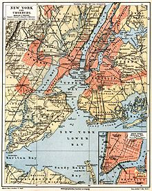
Historic, detailed map (circa 1885) of the region even before the expansion of New York City.

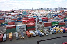
The A.P. Moller Container Terminal at Port Elizabeth, Newark, NJ

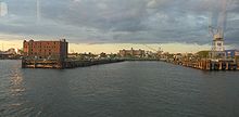
One of the old docks in Brooklyn, Red Hook
Location
The port of New York is located on the border of the US states of New York and New Jersey on the east coast of North America, formed by the Hudson and the Hudson estuary. Nowadays, the urban area of New York City is the dominant feature of the landscape.
The area is, by extension, the northern part of the Atlantic Coastal Plain. North of the harbor area is the Long Island Sound.
Individual plants
- The former Global Marine Terminal
- The facilities operated by the Port Authority (PANYNJ) (partly from 1921):
- Container port in New Jersey, expanded since about 1960 (Port Newark-Elizabeth Marine Terminal)
- Marine Terminal in Red Hook, Brooklyn, NY;
- Auto Marine Terminal in Bayonne, NJ and Jersey City, NJ
- Brooklyn Port Authority Marine Terminal (Joint Terminal of Brooklyn Piers and Red Hook Container Terminal) in Red Hook, Brooklyn, NY, and
- Howland Hook Marine Terminal on Staten Island.
- Passenger Cruise Terminals:
- Manhattan Terminal (New York Passenger Ship Terminal)
- Brooklyn Cruise Terminal
- Cape Liberty Cruise Port in Bayonne, NJ.
- Military installations:
- Bayonne Military Ocean Terminal
- United States Navy Yard, more commonly known as Brooklyn Navy Yard, was a shipyard for warships up to aircraft carrier size. It is located 1.7 miles northeast of Battery Park, in the Brooklyn area, on the Wallabout Bay of the East River, and is still used in part as a private yard today.
- the Brooklyn Army Terminal (formerly New York Port of Embarkation and Army Supply Base or U.S. Army Military Ocean Terminal)
- Just to mention historically, South Street Seaport is a now landmarked neighborhood in Manhattan where Fulton Street meets the East River. This was also once New York's fishing port (now at Hunts Point, Bronx).
- In addition, there are a number of private quay and stacking facilities.

enlarge and show information about the picture
![]()
360° panorama of the harbour, seen from the Empire State Building (photo: April 2005)

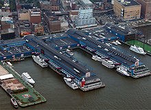
Chelsea Piers on the Hudson River
Search within the encyclopedia