New York City: overview, history, culture, economy, and landmarks
Comprehensive article on New York City covering geography, boroughs, history, economy, demographics, transportation, institutions, landmarks and notable distinctions.
Overview
New York City is widely recognized as the largest city in the United States by population and one of the world’s most influential urban centers. Located at the southern tip of the state of New York, it is the core of a large metropolitan region that includes surrounding counties and suburbs, commonly called the New York metropolitan area. The city’s size and role make it a focal point for finance, media, the arts and higher education, and it draws people from around the globe for work and tourism.
Image gallery
10 Images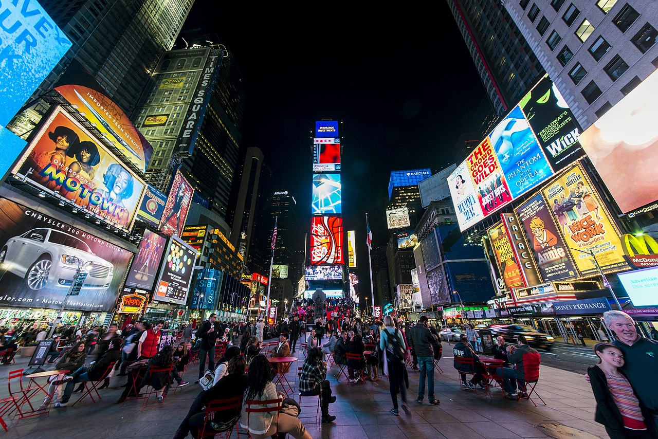


Geography and boroughs
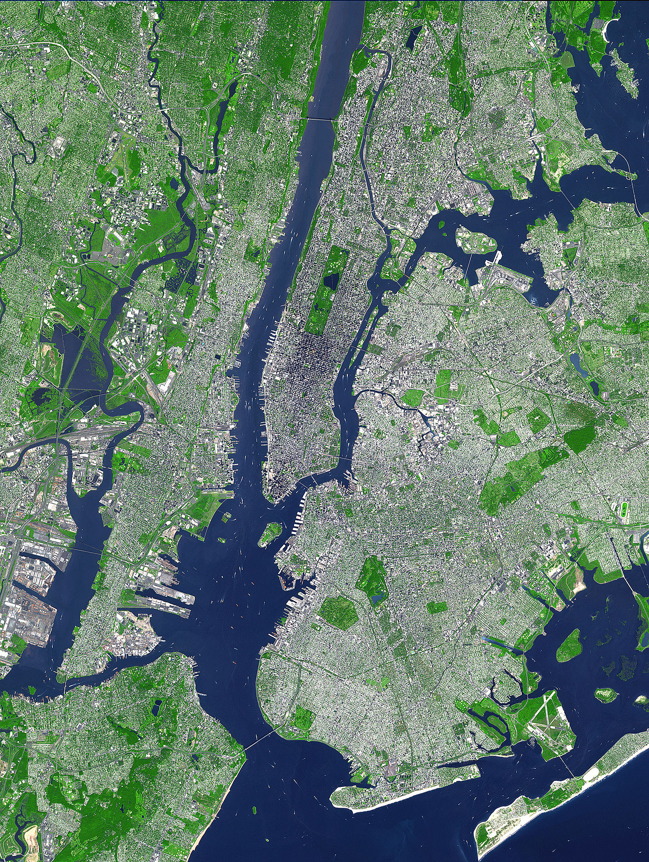
Built around one of the world’s great natural harbors, New York’s geography encouraged maritime trade and dense settlement. The city is administratively divided into five boroughs, each of which corresponds to a county of the state: Brooklyn, Queens, Manhattan, the Bronx and Staten Island. These boroughs were consolidated into a single municipal government in 1898. Shorelines, rivers and islands shape neighborhoods and transportation routes, and the harbor remains important to commerce and recreation.
History and development
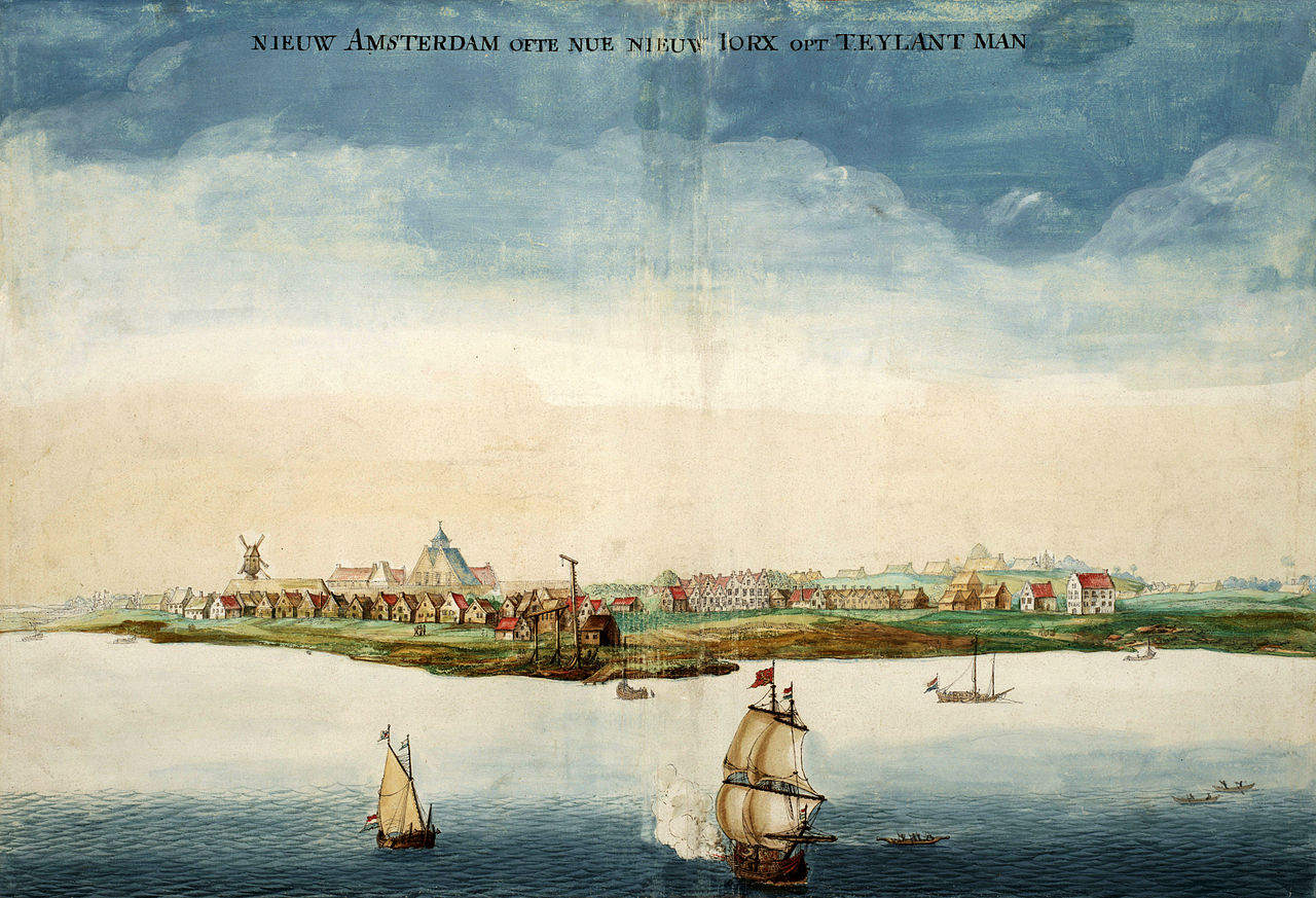
The site of present-day New York City began as a European trading outpost founded by settlers from the Dutch Republic in the early 17th century on what is now Lower Manhattan. The settlement was called New Amsterdam before English control brought a new name in 1664, honoring King Charles II and his brother the Duke of York. In the young United States, the city briefly served as the national capital in the 1780s. Over the 19th and early 20th centuries it expanded rapidly through immigration and industrial growth; the Statue of Liberty became an enduring symbol of welcome and the American ideals of liberty and peace for millions arriving by ship.
Economy, institutions and culture
New York is a global financial center: it hosts the nation’s major securities exchanges and a dense concentration of banks, investment firms and service industries. The New York Stock Exchange and NASDAQ are headquartered on Manhattan island, and financial services cluster around Wall Street and surrounding districts. The city’s economy also supports large media, technology and creative sectors; it is often described as a hub of creativity and entrepreneurship. In recent decades attention to environmental sustainability and resilient infrastructure has become a growing part of municipal planning.
- Major cultural and research institutions include universities such as Columbia University, New York University and Rockefeller University, as well as public systems like the City University of New York.
- The entertainment, publishing and performing arts industries are concentrated in neighborhoods that support theaters, galleries and studios.
Demographics and diversity
New York City is noted for its extraordinary cultural and linguistic diversity; communities from every inhabited continent live and work within the five boroughs. It has one of the largest foreign-born populations of any city in the world and is often cited as the most linguistically diverse city, with hundreds of languages spoken. Ethnic neighborhoods, including multiple Chinatowns and other enclaves, reflect patterns of migration and settlement. The city’s population size compares with other major U.S. cities—often contrasted with Chicago in Illinois—but its density, economic scale and global connections set it apart.
Transportation and infrastructure
Public transit is a defining feature of daily life in New York. The New York City Subway operates as the largest single-operator rapid transit network in the nation and one of the most extensive in the world; the system is a backbone for commuting and urban mobility that complements buses, commuter rail and extensive ferry connections. The city’s streets, bridges and ports support both local travel and international commerce.
Landmarks, tourism and public life
Familiar landmarks and public spaces contribute to New York’s global identity. Times Square, part of the Broadway theater district, is among the best-known intersections and a focal point for entertainment and pedestrian life. Manhattan’s skyline—characterized by iconic skyscrapers and dense clusters of commercial towers—signals the city’s economic role, while parks and waterfront promenades provide recreational space. Tourism brings tens of millions of visitors annually, who come to museums, theaters, historic sites and special events.
Notable distinctions and contemporary role
New York’s combination of population, cultural institutions, financial markets and higher education makes it a central node in global networks of trade, ideas and mobility. As a historic gateway for newcomers and a continuing destination for migrants, the city’s social fabric and urban form have been shaped by successive waves of change. From its early days as New Amsterdam to its present status as a metropolis of commerce and culture, New York’s identity remains linked to maritime geography, immigrant communities, and institutions that influence national and international life. For further reference on topics such as municipal government, neighborhoods and specific institutions see authoritative sources and civic archives accessible online and in libraries (national resources, borough offices, county records and specialist studies).
Selected quick links: stock exchanges and markets, One World Trade Center, the harbor, language diversity, Lower Manhattan history, pedestrian life, rapid transit context, Chinese communities.
Because New York’s institutions and neighborhoods are constantly evolving, readers are encouraged to consult up-to-date municipal data, academic research and reputable news sources for the latest statistics and developments.
Geography
Geographical position
New York City has expanded from the island of Manhattan, which is now its center, projecting as a pointed promontory between the Hudson and East Rivers. It lies in latitude 40.42° north and longitude 74.00° west on the east coast of the United States in New York Bay and in close proximity to Jersey City. It encloses the mouths of the Hudson River and East River into the Atlantic Ocean and rises an average of twenty feet above sea level. The city's buildings and infrastructure spill over from the riverbanks into other major cities in a plethora of suburbs and extend far into the countryside. The urban area has a land area of 785.6 km² (Berlin 891.85 km²), and the total continuous built-up area (the agglomeration) of 8683.2 km². The New York-Northern New Jersey-Long Island Metropolitan Statistical Area covers 17,405 km², the somewhat broader New York-Newark-Bridgeport Combined Statistical Area 30,671 km² (the state of Brandenburg 29,478.61 km²).
Manhattan stands on rocky ground that allows for taller structures to be built. It is surrounded by numerous natural harbors that can be accessed by deep draft vessels. The Hudson opens the main natural route to the hinterland, allowing access via the Mohawk River or Lake Champlain to the Great Lakes to the northwest or the Saint Lawrence River to the north. South of the area, which is more vulnerable to icebergs, the main masses of European immigrants settled. These geographic conditions have enabled New York to achieve a prominent position in the U.S. and world economies.
Geology
The area around the city of New York is part of the Atlantic coastal plain. Further inland, the landscape gradually changes to rolling hills. On Long Island and along the New Jersey coast to the south are sandy beaches.
The coastal plain in which New York lies extends to Jacksonville as the foreland of the southern Appalachians. It consists of sands and clays derived chiefly from moraines and fluviatile deposits. Long spits and hooks are offshore from shallow, richly indented estuaries (Delaware Bay) and river mouths; a broad tidal marsh belt follows inland. At about the latitude of New York, in Long Island, the coastal plain dips below sea level.
City breakdown
→ Main article: New York City administrative division
The city is divided into five boroughs, each of which corresponds to a county in New York State. Each borough is under the jurisdiction of a Borough President.
Manhattan (New York County) has a population of 1,601,948 (as of 2011) and a land area of 59.5 km². The borough consists primarily of Manhattan Island, which is surrounded by the Hudson River to the west, the East River to the east, and the Harlem River to the northeast, as well as other smaller islands, including Roosevelt Island, Belmont Island, Governors Island, and a small piece of the mainland, Marble Hill. Marble Hill was still part of Manhattan Island until the construction of the Harlem River Ship Canal in the 19th century.
Brooklyn (Kings County) has 2,532,645 residents, making it the most populous borough in New York. It is located in the southeast of the city, at the western end of Long Island and has an area of 182.9 km². The city of Brooklyn was named after the Dutch town of Breukelen and was incorporated into New York City in 1898.
40.712777777778-74.005833333333
|
New York City |
|
|
Queens (Queens County) has 2,247,848 inhabitants and is the largest of the five boroughs of New York, with an area of 282.9 km². It is located on the west side of Long Island. Queens was founded on November 1, 1683, when the Colony of New York was divided into counties. In 1898, the borough was incorporated into New York. It is also home to New York's two largest airports, John F. Kennedy International Airport and LaGuardia Airport.
The Bronx (Bronx County) has a population of 1,392,002 and an area of 108.9 km². Formerly an independent city, it has been the northernmost borough of New York since January 1, 1874. It was named after the first settler in the area, Jonas Bronck, who emigrated from what is now Sweden. At the time, to announce a visit to his farm, it was said, "We are going to the Broncks"; today, the name is spelled differently, but the prefixing of the article has been retained, i.e., "The Bronx." Also, the Bronx is the only borough of New York that is on the mainland.
Staten Island (Richmond County) has 470,467 inhabitants and a land area of 151.5 km². It is located southwest of Manhattan Island and west of the borough of Brooklyn, which is located on Long Island. The island is connected to Brooklyn by the toll Verrazzano-Narrows Bridge and to Manhattan by the free Staten Island Ferry. To the west and north, Staten Island is separated from the state of New Jersey by the narrow Arthur Kill and the Kill van Kull. Leading into New Jersey are the Goethals Bridge, the Bayonne Bridge, and the Outerbridge Crossing. The highest point on the island, Todt Hill, is also the highest point in the city of New York. In the past, all of the city's garbage was dumped on Staten Island, which still causes odor problems to some extent. Also the debris of the World Trade Center was brought to Staten Island.
Climate
The average annual temperature is 12.5 °C and the average annual precipitation is 1056.4 millimetres. The warmest month is July with an average of 24.7 °C and the coldest is January with -0.4 °C on average. The most precipitation falls in the month of April with 99.1 millimeters on average, the least in October with 73.2 millimeters on average. The city is thus in the temperate climate zone. New York's weather is predominantly influenced by the continental land masses to the west. Summers are generally tropically warm and winters cold. According to W. Köppen and R. Geiger, New York City is in the warm, humid temperate climate zone.
The temperature often rises above 30 °C in July and August, along with high humidity with sometimes heavy rainfall, often thunderstorms, which often makes the summer weather quite unpleasant. In January, values can drop below -20 °C, although it is often sunny. Occasionally, sea air (the Northeasters - the northeast wind) brings moisture from the Atlantic Ocean, as well as strong winds and heavy rain or snow. One of the most severe and consequential of these snowstorms was the Great Blizzard of 1888, with a snow depth of about 51 inches and about 100 deaths in New York City alone. The previous record snow depth since weather records began was measured at 68 cm in February 2006.
The lowest temperature ever recorded is -26 °C in January and the highest is 41 °C in July.
Water temperatures on the New York coast range from an average of 3°C to 23°C.
| New York City | ||||||||||||||||||||||||||||||||||||||||||||||||
| Climate diagram | ||||||||||||||||||||||||||||||||||||||||||||||||
| ||||||||||||||||||||||||||||||||||||||||||||||||
| Monthly average temperatures and precipitation for New York City
Source: | ||||||||||||||||||||||||||||||||||||||||||||||||||||||||||||||||||||||||||||||||||||||||||||||||||||||||||||||||||||||||||||||||||||||||||||||||||||||||||||||||||||||||||||||||||||||||||||||||
Effects of climate change
New York is affected by global warming due to rising sea levels and the increasing risk of storm surges. It is estimated that, as a result of the climate crisis, the water level in New York could rise by 1.80 meters by 2100 and the number of severe storms and storm surges is expected to increase significantly. Official projections suggest that by 2050, about 37% of buildings on Manhattan's southern tip will be at risk of storm surge, and by 2100, 20% of streets in the area will be flooded daily. One strategy for adapting to global warming is to reinforce 850 km of coastline.


Population
With 8.5 million people, New York City is the largest city in the United States and one of the largest cities in the world. The population has doubled since the beginning of the 20th century. Since 1825, the city's location on the Atlantic Ocean and the Hudson River's inland waterway have made it the go-to place for immigrants from around the world. Further development made New York the largest industrial city and a financial metropolis.
The population of the city is divided into different strata. The upper class lives mainly outside the city or in the expensive district of Manhattan. There are numerous social housing measures in New York and for socially vulnerable people and families, the municipal housing association NYCHA manages a total of 178,000 social housing units, in which around 400,000 people live.
In a 2018 ranking of cities by quality of life, New York City ranked 45th among 231 cities surveyed worldwide.
Population development
New York City population in 2019 is 8,336,817. The population density is 10,356 inhabitants per km². The New York-Newark agglomeration has 18,351,295 residents with a population density of 5,319 residents per km² as of 2010. The New York-Northern New Jersey-Long Island metropolitan area has a population of 18,897,109 as of April 1, 2010, for a population density of 1,086 residents per km² over an area of 17,405 km². The New York-Newark-Bridgeport Combined Statistical Area has a population of 22,085,649 (April 1, 2010), which corresponds to a population density of 720 inhabitants per km².
The following overviews show the population figures according to the respective area status. Up to 1775, these are estimates; from 1790 to 2010, they are census results from the United States Census Bureau.
|
|
| Year | Brooklyn | Queens | Manhattan | Bronx | Staten Island | Total | ||||||
| 182.9 km² | E/km² | 282.9 km² | E/km² | 59.9 km² | E/km² | 108.8 km² | E/km² | 151.5 km² | E/km² | 785.6 km² | E/km² | |
| 1900 | 1.166.582 | 6.378 | 152.999 | 541 | 2.050.600 | 34.464 | 200.507 | 1.843 | 67.021 | 442 | 3.637.709 | 4.630 |
| 1910 | 1.634.351 | 8.936 | 284.041 | 1.004 | 2.762.522 | 46.429 | 430.980 | 3.961 | 85.969 | 567 | 5.197.863 | 6.616 |
| 1920 | 2.018.356 | 11.035 | 469.042 | 1.658 | 2.284.103 | 38.388 | 732.016 | 6.728 | 116.531 | 769 | 5.620.048 | 7.154 |
| 1930 | 2.560.401 | 13.999 | 1.079.129 | 3.815 | 1.867.312 | 31.383 | 1.265.258 | 11.629 | 158.346 | 1.045 | 6.930.446 | 8.822 |
| 1940 | 2.698.285 | 14.753 | 1.297.634 | 4.587 | 1.889.924 | 31.763 | 1.394.711 | 12.819 | 174.441 | 1.151 | 7.454.995 | 9.490 |
| 1950 | 2.738.175 | 14.971 | 1.550.849 | 5.482 | 1.960.101 | 32.943 | 1.451.277 | 13.339 | 191.555 | 1.264 | 7.891.957 | 10.046 |
| 1960 | 2.627.319 | 14.365 | 1.809.578 | 6.397 | 1.698.281 | 28.543 | 1.424.815 | 13.096 | 221.991 | 1.465 | 7.781.984 | 9.906 |
| 1970 | 2.602.012 | 14.226 | 1.987.174 | 7.024 | 1.539.233 | 25.869 | 1.471.701 | 13.527 | 295.443 | 1.950 | 7.895.563 | 10.050 |
| 1980 | 2.310.028 | 12.630 | 1.891.325 | 6.685 | 1.428.285 | 24.005 | 1.168.972 | 10.744 | 352.029 | 2.324 | 7.150.639 | 9.102 |
| 1990 | 2.300.664 | 12.579 | 1.951.598 | 6.899 | 1.487.536 | 25.001 | 1.203.789 | 11.064 | 378.977 | 2.501 | 7.322.564 | 9.321 |
| 2000 | 2.465.326 | 13.479 | 2.229.379 | 7.880 | 1.537.195 | 25.835 | 1.332.650 | 12.249 | 443.728 | 2.929 | 8.008.278 | 10.194 |
| 2010 | 2.504.700 | 13.694 | 2.230.722 | 7.885 | 1.585.873 | 26.653 | 1.385.108 | 12.731 | 468.730 | 3.094 | 8.175.133 | 10.406 |
Population groups and origin
The composition of New York's population is very heterogeneous and reflects all waves of immigration in American history. The largest group is non-Hispanic whites (Caucasians) at 35%. Two out of five residents were not born in the United States; most of the European-born immigrants are from Italy (8%), Ireland (5%), and Germany (3%). About 972,000 residents are of Jewish faith or descent, making up 12% of the total population. In Manhattan, the proportion is even about 20%. New York City is thus the city with the largest Jewish community in the world, as more Jews live here than the entire population of Jerusalem.
The proportion of non-Hispanic blacks or African-Americans is 24% and, like that of whites, is declining in line with the overall American trend. Hispanics (Latinos), on the other hand, are now the second largest population group with a total of 27%. Asians are the fastest growing group and now make up 12% of New York's population.
African Americans, whites, Asians, and Hispanics each tend to concentrate in certain neighborhoods. Thus Manhattan (Downtown and Midtown up to Central Park), with the exception of Chinatown, is predominantly a residential area of whites; in northwestern Brooklyn live predominantly blacks, as well as in the streets north of Central Park (Harlem); in the northwestern districts of Queens, south of La Guardia, live predominantly Latinos and a few Asians; in the Bronx live hardly any whites, but a majority of Hispanics and some blacks, and in southern Brooklyn (Coney Island) live people of Russian origin in particular. In recent years, however, there have been some contrary trends here; for example, the proportion of African-Americans among the residents of Harlem is now less than 50 %, as Latinos and whites have moved into the neighbourhood, which for a long time was almost exclusively inhabited by blacks.
40.6% of residents were not born in the United States, including 19.2% in Latin America (excluding Puerto Rico), 9.4% in Asia, and 6.4% in Europe.
The following two tables detail the statistical data on the population groups (race and ethnicity) of New York residents. All data are self-reported by the respondents.
| Populations | Census 1990 | Census 2000 | ACS1) |
| White | 52,3 % | 44,7 % | 44,3 % |
| - non-Hispanics | 43,2 % | 35,0 % | 33,1 % |
| 9,1 % | 9,7 % | 11,2 % | |
| Black/African American | 28,7 % | 26,6 % | 24,9 % |
| - non-Hispanics | 25,2 % | 24,5 % | 22,7 % |
| - Hispanics | 3,5 % | 2,1 % | 2,2 % |
| 7,0 % | 9,8 % | 13,0 % | |
| Two or more races | N/A | 4,9 % | 3,0 % |
| American Indian and Alaska Native | 0,4 % | 0,5 % | 0,4 % |
| Other | 11,6 % | 13,5 % | 14,4 % |
| - Hispanics | 11,4 % | 12,7 % | 13,6 % |
| Total Hispanics/Latinos | 24,4 % | 27,0 % | 28,7 % |
1) The American Community Survey is a representative study conducted by the U.S. Census Bureau with random sampling of the population to obtain more current data.
| Origin/ancestry | Census 1990 | Census 2000 | ACS2005-2007 |
| 12,2 % | 9,9 % | 9,5 % | |
| 10,2 % | 8,7 % | 8,2 % | |
| West Indians (excluding Hispanics) | 5,1 % | 6,9 % | 7,5 % |
| 3,3 % | 4,5 % | 5,3 % | |
| 5,4 % | 5,3 % | 5,1 % | |
| 3,9 % | 3,2 % | 3,3 % | |
| 2,1 % | 3,0 % | 3,3 % | |
| 0,8 % | 2,3 % | 3,2 % | |
| 3,3 % | 3,0 % | 3,0 % | |
| 1,3 % | 2,1 % | 2,8 % | |
| 2,9 % | 2,7 % | 2,7 % | |
| 2,1 % | 2,3 % | 2,7 % | |
| 0,7 % | 1,5 % | 2,2 % | |
| 1,0 % | 1,1 % | 1,1 % | |
| 0,6 % | 0,9 % | 1,1 % | |
| 1,0 % | 1,0 % | 1,0 % | |
| different origin | 31,8 % | 37,1 % | 38,0 % |
| without assignment/without specification | 12,3 % | 4,5 % | N/A |
Languages
Just over half of the population speaks only English at home, while almost a quarter of residents do not have a very good command of English. The second most important language is Spanish, which is used by 24% of New Yorkers at home. The other languages together account for 23%.
| Mother tongues | Census 1990 | Census 2000 | ACS2005-2007 |
| 59,0 % | 52,4 % | 52,4 % | |
| 22,0 % | 24,5 % | 24,3 % | |
| k. A. | 4,3 % | 4,9 % | |
| k. A. | 2,6 % | k. A. | |
| k. A. | 2,0 % | k. A. | |
| k. A. | 1,9 % | k. A. | |
| k. A. | 1,4 % | 2,4 %3) | |
| French Creole | k. A. | 1,2 % | k. A. |
| k. A. | 1,1 % | k. A. | |
| k. A. | 1,0 % | 1,0 % | |
| other languages | 19,0 % | 7,6 % | 15,0 % |
| English (mother tongue and second language) | 80,0 % | 76,3 % | 76,8 % |
1) incl. Spanish Creole; 2) incl. Patois and Cajun; 3) incl. French Creole


Questions and answers
Q: What is the population of New York City?
A: The population of New York City is over 8 million people.
Q: How many people live in the greater New York metropolitan area?
A: Over 22 million people live in the greater New York metropolitan area.
Q: What is the significance of One World Trade Center in NYC?
A: One World Trade Center is significant because it is home to the nation's stock market, Wall Street.
Q: How many boroughs make up NYC?
A: Five boroughs make up NYC - Brooklyn, Queens, Manhattan, The Bronx and Staten Island.
Q: What makes NYC linguistically diverse?
A: As many as 800 languages are spoken in NYC, making it one of the most linguistically diverse cities in the world.
A record 62.8 million tourists visited NYC in 2017.
Q: How many tourists visited NYC in 2017? A:
Related articles
Author
AlegsaOnline.com New York City: overview, history, culture, economy, and landmarks Leandro Alegsa
URL: https://en.alegsaonline.com/art/69653
Sources
- hotword.dictionary.com : "Why is New York City known as 'the Big Apple' and "Gotham?""
- pbs.org : "General Article: New York After WWII"
- nyc.gov : "About New York City"
- baruch.cuny.edu : "FORWARD New York – Capital of the Modern World"
- census.gov : "US Gazetteer files: 2010, 2000, and 1990"
- nyc.gov : nyc.gov/portal/site/nycgov/menuitem.e985cf5219821bc3f7393cd401c789a0/
- geonames.usgs.gov : "US Board on Geographic Names"
- factfinder.census.gov : "Annual Estimates of the Resident Population: April 1, 2010 to July 1, 2017 – Combined Statistical Area; and for Puerto Rico – 2017 Population Estimates"
- factfinder.census.gov : Community Facts for New York city, New York
- quickfacts.census.gov : "State & County QuickFacts – Kings County (Brooklyn Borough), New York"
- worldstatesmen.org : "Boroughs of New York City" · web.archive.org · web.archive.org