Neubrandenburg — historic city on the Tollensesee in Mecklenburg-Western Pomerania
Neubrandenburg is a northeastern German city on the Tollensesee, founded in 1248. Known for its brick Gothic heritage, surviving medieval gates, cultural venues and lakeside recreation.
Overview
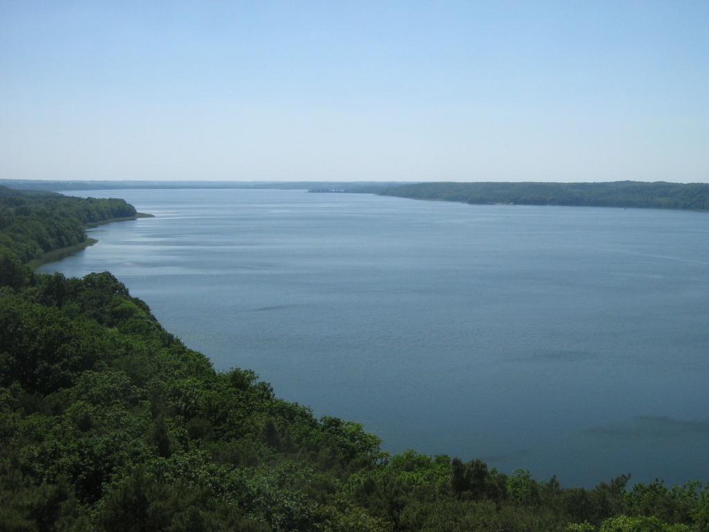
Neubrandenburg is a city in the state of Mecklenburg-Western Pomerania in northeastern Germany, situated on the shore of the Tollensesee. Founded in 1248, it developed into a regional centre with a compact historic core, green surroundings and a riverside-lake setting that shapes local life and tourism. The city is often noted for its late medieval brick architecture and remnants of fortifications that remain visible in the urban landscape.
Image gallery
10 Images


History and development
Founded in the 13th century by local nobility, Neubrandenburg grew from a fortified settlement into a market and administrative town. Over the centuries it experienced the same broad currents as other places in northern Germany: medieval urban growth, the Reformation era, the changes of modern state boundaries, and twentieth-century reconstruction. Its municipal status and administrative arrangements have changed over time; until 4 September 2011 the city was an urban district in its own right. Since 2015 the office of mayor has been held by Silvio Witt.
Architecture and urban character
Neubrandenburg is best known for its Brick Gothic fabric: large red-brick public buildings, churches and the remains of a city wall with several well-preserved gate towers. The historic pattern of streets around the old market and church contrasts with later nineteenth- and twentieth-century neighbourhoods. Public spaces and a concert venue housed in a former church building contribute to an active cultural life that draws both residents and visitors.
Culture, education and economy
The city hosts theatres, museums and music events, and supports a range of educational institutions including applied higher-education establishments. Economically, Neubrandenburg combines local services, light industry and a tourism sector linked to the Tollensesee and surrounding lakes and forests. Recreation on the water, cycling and walking routes are a regular part of the local offer, and green spaces near the shore are important for quality of life.
Notable features and visitor highlights
- Distinctive Brick Gothic buildings and surviving sections of the medieval town wall with gate towers.
- The Tollensesee shoreline and parks, used for boating, swimming and seasonal events.
- A compact historic centre with cultural venues, museums and concert programming.
- Local festivals, markets and educational institutions that anchor civic life.
Further information
For context about the federal state in which Neubrandenburg is located, see the entry on the region: Mecklenburg-Western Pomerania. For the city's name and pronunciation history consult linguistic or place-name resources: name and language notes. Administrative changes such as its former urban-district status are discussed in regional governance summaries: administrative status.

Geography
Geographical location
Neubrandenburg is located in the southeast of Mecklenburg at an altitude of 18 meters above sea level (city center) on the northern shore of the Tollensesee, which belongs to the city, and in the river valleys of the Tollense and Datze, which begin here, and the Linde, which flows into the Tollensesee, as well as the surrounding elevations of the ground moraine plates about halfway between Berlin and the island of Rügen. In addition to the Tollensesee, the Lieps, which is connected to it to the south, also belongs to the area of the town; this lake is part of the Nonnenhof nature reserve. The nearest conurbations are Szczecin 90 km to the east, Rostock 110 km to the northwest, Berlin 140 km to the south and Hamburg 250 km to the west.
Alongside the regional centre of Rostock, the state capital Schwerin and the two cities of Stralsund and Greifswald in Western Pomerania, Neubrandenburg is one of the main centres of Mecklenburg-Western Pomerania and is therefore important for the entire south-east of the state. Since 1995, the city has been a member of the transnational federation of the Euroregion Pomerania.
City breakdown
Urban areas and parts of urban areas according to the official urban area classification of 5 October 1995:
City centre (with Jahnviertel)
The historic old town of Neubrandenburg, now called the city centre, which until the middle of the 19th century (with a few exceptions) provided living space for the entire city population, is still the cultural and tourist heart of Neubrandenburg today. Today, about 3800 people live here (as of 2018).
In the town centre, which was laid out almost circularly as a planned town, the streets are arranged in a rectangular pattern from north to south and from east to west in parallel. All streets were laid out on visual axes to each other in interaction with the city wall, the city gates, fortified towers and weigh houses. This concept was only deviated from by the reconstruction after the Second World War with the new buildings of the police quarter and the House of Culture and Education (HKB); the remaining street layouts were largely retained, but the street widths were mostly significantly extended.
Shortly before the end of the Second World War, more than 80 per cent of the predominantly 18th and 19th century buildings in the Old Town were destroyed by systematic burning by the Red Army. All the public buildings in the Old Town and the majority of the bourgeois residential and commercial buildings within the city walls fell victim to the major fire on 29/30 April 1945, including the (grand) ducal palace (Stadtschloss) and the old town hall on the market square.
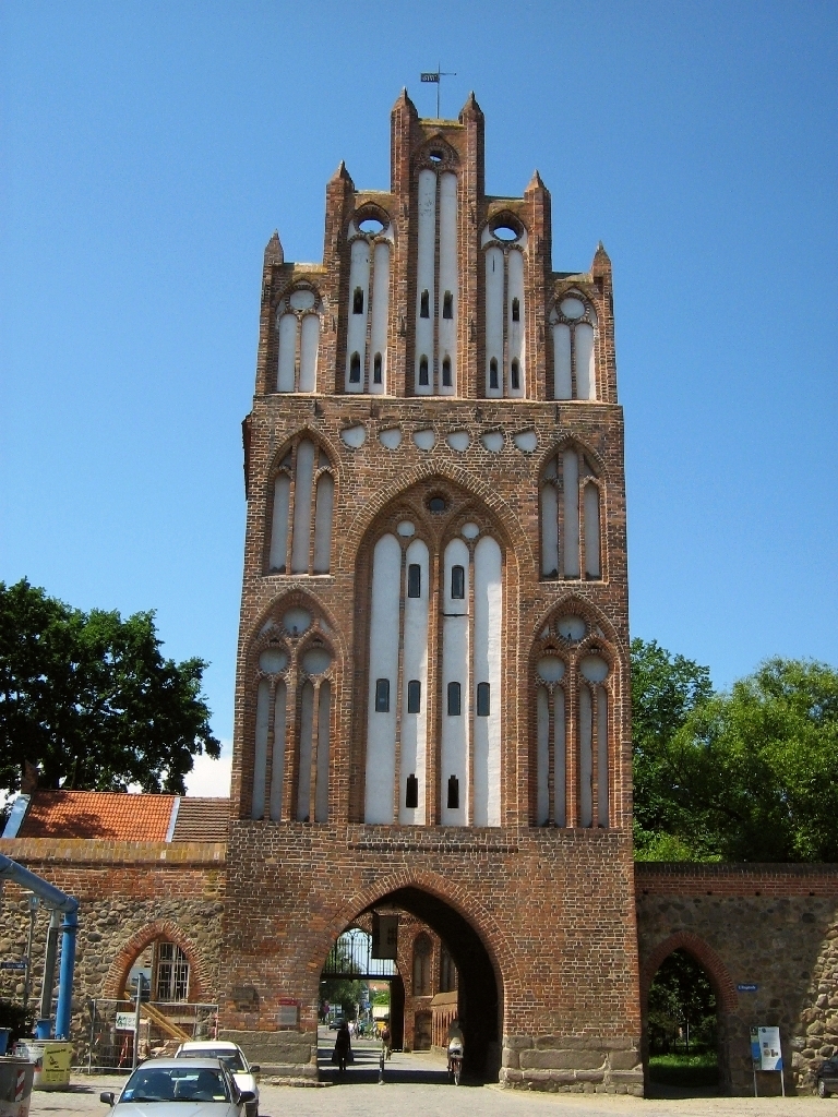
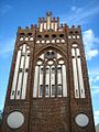
Today, only smaller ensembles and a few important individual buildings remain from the former townscape, above all the medieval fortification with town wall, four Gothic town gates, one (of originally two) fortified towers (Fangelturm) and so far 25 (of once 56) newly built Wiekhäuser in half-timbered construction. Today's third-generation Wiekhäuser, built in the 1970s and 1980s, are only roughly based on the exterior design of previous buildings; the spatial concepts have completely broken with those of the previous buildings and follow modern functional requirements. Three Wiekhäuser were reconstructed in the early 20th century in their original medieval state as fortified buildings. Second-generation Wiekhäuser, as they had been built for residential purposes since the 17th century as simple, plastered half-timbered buildings in the city wall, existed in part until the 1950s. All of today's half-timbered Wiekhäuser are new buildings of the 1970s and 1980s with exposed half-timbering, which on the outside are oriented towards the predecessor buildings and on the inside pursue new design and spatial concepts. Historic about today's third-generation Wiekhäuser are mostly, but not always, the places where they are built into the city wall. (See also: Neubrandenburg Wiekhäuser)
The former monastery complex (the north wing is now part of the regional museum) with the monastery church of St. Johannis, the former main parish church of St. Marien (after reconstruction used as a concert church since 2001), the Schauspielhaus (Mecklenburg's oldest preserved theatre building), as well as in the south of the old town some ensembles with baroque and classicist residential buildings have been preserved (Große Wollweberstraße, parts of Pfaffenstraße, Neutorstraße and Stargarder Straße).
· "City of Four Gates"
· 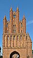
Friedländer Gate, city side
· 
Treptower Gate, field side
· 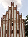
Stargarder Tor, city side with adorants
· 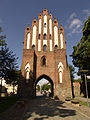
New gate, field side
The reconstruction of the inner city since the 1950s changed the cityscape fundamentally. Most of the residential buildings today date from the GDR era. The historicizing new buildings, loosely oriented on the baroque and classicist pre-war architecture of the Mecklenburg city, were characteristic of this and were built in the 1950s. In the spirit of the cultural programme of the time, they were built from 1951 onwards in accordance with the "16 principles of urban development" in an architectural style that continued the "national cultural heritage", which in cultural-historical terms is also referred to as Socialist Classicism.
Some buildings were added later, such as the Kaufhof (Centrum Warenhaus) in the 1960s, individual residential buildings and the modernist "House of Culture and Education" (HKB) with its 56-metre-high high-rise tower. From 1990 onwards, almost all the buildings in the city centre were gradually renovated from the ground up. A shopping centre was built on an area of the city bordering the market, which had been kept in reserve for cultural buildings in GDR times. Decentralized fallow and demolition areas were mostly filled with small-scale new buildings (example: Fischerstraße quarter).
Shopping facilities are available in the city centre with the Marktplatz-Center, newly built in 1998 on the western side of the market square, and two department stores as well as small shops, which are mainly located in the pedestrian zone Turmstraße ("Boulevard"), Wartlaustrasse and along Stargarder Straße and in the part of Treptower Straße close to the market square.
The market square was modernistically renovated by 2009 and equipped with water features and a new lighting concept. In the course of this work, the city centre also received an additional underground car park under the market square. During the construction work, all remains of the palace and medieval predecessor buildings of the town hall on the market square were cleared away following archaeological investigations. Only the foundations of the old town hall from the 18th century remained in the ground.
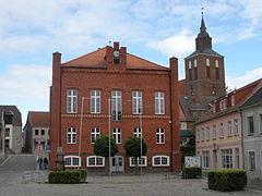
In the direct vicinity of the old town are the railway station (once connected by the "station gate" of the 19th century) and the bus station to the north, the New Town Hall to the east and the entrance to the Kulturpark with the adjacent Tollensesee lake to the south.
The Jahnviertel (also known as the Nachtjackenviertel by the people of Neubrandenburg), which borders to the west and northwest, is dominated by representative middle-class buildings from the Gründerzeit and the years between 1875 and 1914, supplemented by new buildings from the post-reunification period. Outside the old town centre, it is one of the few districts in the city that is characterised in parts by urban perimeter block development. The official name of the quarter is derived from the centrally located Jahnstraße, which, together with the Jahn monument standing there, is a reminder of the time when gymnastics father Friedrich Ludwig Jahn was a teacher in Neubrandenburg. The term Nachtjackenviertel, on the other hand, indicates that this area of the city was already an attractive residential area for the better-off in earlier times, as the villa owners are said to have appeared at the door later in the morning in their "night jackets".
Catherine Quarter
East of the city centre lies the Katharinenviertel. With approximately 3200 inhabitants (as of 2018), it is the smallest quarter of the city. In this area of the city are, among other things, the former citizen school (today: Regional School Mitte "Fritz Reuter"), the municipal cinema "Latücht", the district music school Kon.centus, the adult education centre (formerly the district administration office) and the New Catholic Church. Of the "old cemetery", the first decentralized main cemetery of the city, which was inaugurated in 1804, gradually abandoned from the 1960s and completely built over in the 1980s, only the cemetery chapel built according to the plans of Friedrich Wilhelm Buttel and a last family tomb directly next to it remain today.
From Katharinenviertel, you can get directly to the Mühlenholz forest area in the Lindetal landscape conservation area. There you will also find the Hinterste Mühle, a historic site in the middle of nature with a petting zoo, nature trails, horse farm and leisure activities for children and young people. There is also the site of Dirt Force Neubrandenburg, northern Germany's largest bike park. On the edge of the Katharinenviertel is the "Phönixeum", a high-rise office building with an unusually colourful design.
City area west (with Rostock quarter, Broda and Weitin)
The West urban area is one of the largest urban areas, along with the East urban area and the Reitbahnviertel. Here live about 8700 people (as of 2018) in partly seven-storey, mostly renovated prefabricated buildings, but also in single or multi-family houses (Broda, Weitin). In the Rostock quarter of the Weststadt there is the residential and shopping quarter Oberbach-Zentrum and other shops. The University of Applied Sciences Neubrandenburg is located here on a campus area. The Rostock quarter is located near the Tollensesee directly at the Oberbach, an artificial outflow of the Tollensesee already built in the Middle Ages. However, the Tollensesee itself belongs administratively to the Lindenbergviertel. In the western part of the town the traditional and successful Sportclub Neubrandenburg (SCN) is located. The canoeists train regularly on the Oberbach and the Tollensesee.
The former villages Weitin and Broda belong to the town area West. Broda (West Slavic: ford, place at the ford) was a medieval ferry town on the northern shore of the Tollensesee and at the same time the name for the Broda monastery of the Premonstratensian order, which was of central importance for the colonization of this region. After the secularization of the monastery in the middle of the 16th century, it became a ducal Mecklenburg administrative office, which was dissolved shortly before 1800. Today, only individual cellar rooms under the former tenant's house remain from the monastery facilities, which are only accessible by appointment or on occasional guided tours (see also Prehistory).
From the development for family and terraced houses in the 1990s, the residential areas are divided into Broda, Broda-Dorf, Brodaer Höhe, Am Brodaer Holz, Broda-Neukrug and Broda-Stadtkoppel.
Broda also includes the Brodaer Holz, the Brodaer Strand on the Tollensesee, and the landscape park Brodaer Teiche. The landmark and best-known building in the western part of the town is the Belvedere, which can be seen from afar and is located on the steep bank of Lake Tollensee.
Bird Quarter
Between the city centre and the Reitbahnviertel, directly north of the railway station, is the Vogelviertel, where about 4500 people live (as of 2018). Mainly red brick row houses from the 1930s, plain old new buildings from the 1950s and some (mostly renovated) prefabricated buildings as well as isolated row houses from the 2000s characterize the image of Neubrandenburg's second smallest district.
With a few exceptions, the streets of the Vogelviertel bear the names of bird species, such as the centrally located "Kranichstraße". The largest grammar school in the city, the Albert-Einstein-Gymnasium, is located in the east of the city area. The Evangelical Lutheran parish "St. Michael" has its seat in its vicinity.
Reitbahnviertel
North of the Vogelviertel and the city centre lies the Reitbahnviertel. In the 1980s, 3033 prefabricated apartments were built here for over 7500 people. Currently, around 4200 people live here (as of 2018). Since 1993, the residential environment in the quarter has been improved and the apartments redeveloped as part of urban development funding. This was followed by further urban redevelopment from 2003 and in the 2010s.
Urban area east (with Oststadt, Carlshöhe, Fritscheshof, Küssow)
With a current population of around 15,300 (as of 2018), Oststadt is Neubrandenburg's largest district. At peak times, even about 25,000 people lived here. It is a residential district with over 8700 apartments in mostly renovated prefabricated buildings (built between 1970 and 1989) and owner-occupied housing estates. In the Oststadt there are several schools, the Dietrich-Bonhoeffer-Klinikum Neubrandenburg, the shopping centre Lindetalcenter, the two municipal cemeteries (Neuer Friedhof and Waldfriedhof) and, in the outskirts of the city, larger industrial areas. With the Ihlenpool, the Oststadt has a local recreation area with its own small pond. The first GDR-wide prefabricated housing block of the type WBS 70 was built in Neubrandenburg's Oststadt in 1973 at Koszaliner Straße 1.
The former extensions (today owner-occupied housing estates) Carlshöhe and Fritscheshof as well as the incorporated village of Küssow, a small village with medieval church ruins, border on the Oststadt. Küssow is home to one of Neubrandenburg's largest allotment garden sites, which is run by five different allotment garden associations.
Urban area south (with Südstadt, Fünfeichen)
Südstadt is a district located south of the city centre. Its appearance is characterised by old new buildings from the early 1960s and a number of high-rise buildings from the 1970s and 1980s (directly on the B 96 towards Berlin). In the urban area, which has about 7000 inhabitants (as of 2018), are located, among other things, the sports high school, other schools and kindergartens, the municipal swimming pool and the headquarters of the Neubrandenburger Stadtwerke. Part of the cultural park also belongs to Südstadt.
The district of Fünfeichen developed from a former estate and today houses, in addition to some residential buildings, primarily the barracks of the Bundeswehr telecommunications battalion stationed there. On the subject of the prisoner of war or special camp in Neubrandenburg-Fünfeichen, see the article Stammlager Neubrandenburg/Fünfeichen.
Lindenbergviertel (with Lindenberg, Tannenkrug and Landwehr)
The Lindenbergviertel forms the southern end of Neubrandenburg's urban area. While the northern part of the Lindenberg was initially a typical GDR new construction area with predominantly six-storey prefabricated buildings, the residential area was expanded after reunification with small-scale residential development and as a commercial location and administrative headquarters. In 2018, more than 7200 people lived here.
Datzeviertel (with Datzeberg)
The Datzeviertel, which mainly includes the "Datzeberg", is located on a hill north of the city centre and is named after a small river at the foot of the hill. Towards the end of the 1970s (completion of the first block of flats 6 March 1978) a typical GDR new building area was created here with seven high-rise buildings with 14 storeys as well as mainly five-storey prefabricated slab buildings with a total of 3474 flats for about 10,000 people. It also included three polytechnic secondary schools (19th, 20th and 21st POS), an HO department store and various service facilities. It was connected with the city centre and the other districts by several bus lines.
Since 1993, the residential environment in the Datzeviertel has been improved as part of urban development funding and apartments have been renovated. This was followed by further urban redevelopment from 2003 onwards. Many prefabricated buildings were and are being demolished or dismantled, while at the same time some new buildings are being constructed.
After a sharp drop in the number of inhabitants, especially in the 1990s, the number of people living in the Datzeviertel has stabilized at around 4800 people (as of 2018).
Industrial quarter (with Ihlenfelder Vorstadt, Monckeshof)
The urban area of Industrieviertel comprises a mixed area to the northeast of the old town, where various industrial enterprises (brewery, energy combine, tyre factory), most of which have now disappeared, had settled since the beginning of the 19th century. Today's urban district Ihlenfelder Vorstadt grew northeast of the old town in the course of the expansion of Neubrandenburg since the early 19th century.
The urban district Monckeshof goes back to a so-called expansion (an agricultural estate within the Stadtfeldmark), which was founded after the separation of the Stadtfeldmark (1865) by the miller's son Julius Moncke (1841-1901) on the land assigned to him. In GDR times, mainly prefabricated slab buildings were erected here, which were partly reduced in size or demolished after reunification and supplemented by single-family houses and terraced houses. Currently, the urban area has about 6000 inhabitants (as of 2018).
Surrounding area and city region
As a regional centre, Neubrandenburg fulfils a particularly prominent function for its region. The region immediately surrounding the city is referred to as an "urban-surrounding area" in the Regional Spatial Development Programme of 2011. The municipalities organised in this area are to coordinate their planning activities closely (e.g. housing, commercial development, transport/public transport, education, culture, tourism, leisure facilities - coordinated by the Lower Regional Planning Authority). Residential construction projects, for example, should in future concentrate on the inner areas of the municipalities.
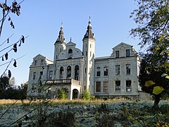
The following 14 municipalities or districts belong to the Neubrandenburg city-surrounding area: Alt Rehse (Penzlin), Blankenhof, Burg Stargard, Groß Nemerow, Groß Teetzleben, Holldorf, Neddemin, Neuenkirchen, Neverin, Sponholz, Trollenhagen, Woggersin, Wulkenzin and Zirzow. Other basic centres close to the core city of Neubrandenburg (radius max. 30 km) besides Burg Stargard and Penzlin are Altentreptow, Friedland, Stavenhagen and Woldegk, the nearest medium-sized centres are Neustrelitz, Demmin and Waren (Müritz).
· 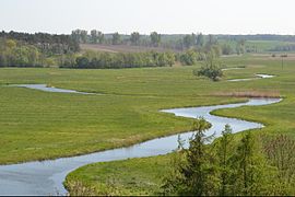
River Tollense, popular canoeing area
· 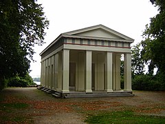
Belvedere above the Tollensesee
· 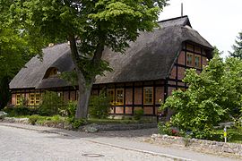
Half-timbered house in Alt Rehse
· 
Mallin Manor
· 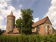
Medieval hilltop castle in Burg Stargard
· 
Old town of Altentreptow
County seat
According to the decision of the state parliament on April 5, 2006, there was to be a greater district of Mecklenburg-Western Pomerania with the district capital Neubrandenburg in the course of the district area reform of Mecklenburg-Western Pomerania in 2009 as of October 1, 2009. This greater district was to include the former districts of Müritz, Demmin and Mecklenburg-Strelitz as well as the former independent city of Neubrandenburg. After the decision of the state constitutional court of 26 July 2007, the reform law could not be implemented as incompatible with the constitution of the state. By resolution of the state parliament of 7 July 2010, the "Law for the Creation of Sustainable Structures of the Counties and County-Free Cities of the State of Mecklenburg-Vorpommern (County Structure Act)" was adopted, which ordered the formation of a county of Mecklenburgische Seenplatte with the county seat in Neubrandenburg.
See also: Kreisgebietsreform Mecklenburg-Vorpommern 2011
Climate
| Neubrandenburg | ||||||||||||||||||||||||||||||||||||||||||||||||
| Climate diagram | ||||||||||||||||||||||||||||||||||||||||||||||||
| ||||||||||||||||||||||||||||||||||||||||||||||||
| Monthly average temperatures and precipitation for Neubrandenburg
Source: | ||||||||||||||||||||||||||||||||||||||||||||||||||||||||||||||||||||||||||||||||||||||||||||||||||||||||||||||||||||||||||||||||||||||||||||||||||||||||||||||||||||||||||||||||||||||||||||||||||||||||||||||||||||||||||||||||||||||||||||||||||||||||||||


Politics
City Council
Local elections 2019
Voter turnout: 52.0 % (2014: 39.9 %)
%
30
20
10
0
25,3 %
23,7 %
16,4 %
16,0 %
11,2 %
3,4 %
0,8 %
3,2 %
gains and losses
The city council of the city of Neubrandenburg consists of 43 deputies. Since the local elections in Mecklenburg-Vorpommern in 2019, it is composed as follows:
See also: Results of the local elections in Neubrandenburg
Mayor
Silvio Witt has been the Lord Mayor of the City of Neubrandenburg since 1 April 2015. After the previous mayor Paul Krüger (CDU) did not run again in the 2015 mayoral election for reasons of age, Silvio Witt (independent) prevailed in the run-off election on 15 March 2015 against Torsten Koplin (Die Linke) with 69.7% to 30.3% of the vote.
Mayor or Lord Mayor (since the beginning of the 19th century):
- (before 1800)-1815: Hans Toll, mayor
- 1815-1826: Friedrich Rahtkens, mayor
- 1816-1830: Friedrich Müller, mayor
- 1826-1847: Karl Moll, mayor
- 1830-1883: Friedrich (II.) Brückner, mayor
- 1847-1851: Ludwig (the elder) Roggenbau, mayor
- 1851-1863: Hans Wulfleff, mayor
- 1863-1889: Wilhelm Ahlers, mayor
- 1883-1904: Gustav (III.) Brückner, mayor
- 1889-1923: Adolf Pries, mayor
- 1923-1933: Hubert Exss, mayor
- 1933–1933: (N. N.) Lüder, State Commissioner
- 1933-1934: Ernst Retzlaff, mayor (NSDAP)
- 1934-1945: Walter Hamann, mayor, from 1939 lord mayor
- 1945-1945: Kurt Mücklisch, Lord Mayor
- 1945-1950: Friedrich Schwarzer, Lord Mayor, from 1946 mayor
- 1950-1952: Charlotte Schlundt, Mayoress
- 1952-1961: Walter Rösler, mayor
- 1961-1963: Otto Prix, Mayor
- 1963-1967: Horst Jonas, Mayor (SED)
- 1967-1968: Ilse Höwe, mayoress
- 1968-1990: Heinz Hahn, Mayor, from 1969 Lord Mayor (SED)
- 1990-1994: Klaus-Peter Bolick, Lord Mayor (CDU)
- 1994-2001: Gerd zu Jeddeloh, Lord Mayor (independent for PDS, SPD and Greens)
- 2001-2015: Paul Krüger, Lord Mayor (CDU)
- since 2015: Silvio Witt, Lord Mayor (non-party)
County Council Elections
In the district council elections the inhabitants of the town vote for the district council of the county Mecklenburgische Seenplatte, for further information see there.
More details on the election procedure and legal provisions: County Council (Mecklenburg-Western Pomerania)
State elections
In the elections to the state parliament, the city area consists of two constituencies. The state parliament constituency Neubrandenburg I and the state parliament constituency Neubrandenburg II.
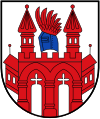
Coat of arms
|
| Blazon: "In silver, a six-pinned red city gate with an open Gothic double portal and two pointed towers, each with two betaglit windows side by side, flanked by side wings, each with two betaglit windows side by side and a peaked roof, both roofs studded with a pommel; on the central battlements, a side-swept blue bucket helmet with a red eagle's flight." The coat of arms was confirmed on 11 May 1966 by resolution of the town council, redrawn in 1994 and registered under No. 40 of the coat of arms roll of the state of Mecklenburg-Western Pomerania. |
| Coat of arms justification: The coat of arms was designed after the seal image of the SIGILLVM BVRGENSIVM CIVITATIS NOVE BRANDEBORCH - first surviving as an imprint in 1287. With the city gate Neubrandenburg is marked as a strongly fortified city. The bucket helmet and crest represent the coat of arms of the city's founder, Margrave Johann I of Brandenburg. |
Flag
The flag has red, white and red stripes across the long axis of the flag cloth. The red stripes take up one fifth each, the white stripe takes up three fifths of the length of the flag cloth. The white stripe is covered in the middle with the figures of the city coat of arms: with a sixfold pinned red city gate with an open gothic double portal and two pointed towers, each with two day-lit windows next to each other, flanked by side wings, each with two day-lit windows next to each other and a peaked roof, both roofs studded with a pommel; on the middle battlements with a laterally turned blue bucket helmet with a red eagle flight. The figures occupy a total of five-ninths of the height and about one-fourth of the length of the flag cloth. The length of the flag cloth relates to the height as 5:3.
Official seal
The official seal shows the city coat of arms with the inscription "VIERTORE-STADT NEUBRANDENBURG".
Twinning
- Italy
 Collegno in Italy, since 1965
 - Germany
 Flensburg in Schleswig-Holstein, since 1987
 - Denmark
 Gladsaxe in Denmark, since 1990
 - Poland
 Koszalin (German: Köslin) in Poland, since 1974
 - Israel
 Nazareth in Israel, since 1998
 - France
 Nevers in France, since 1973
 - Russia
 Petrozavodsk in Russia, since 1983
 - France Villejuif in France, since 1966
- China People's Republic of
 Yangzhou in China, since 1999


Related articles
Author
AlegsaOnline.com Neubrandenburg — historic city on the Tollensesee in Mecklenburg-Western Pomerania Leandro Alegsa
URL: https://en.alegsaonline.com/art/69296
Sources
- destatis.de : "Alle politisch selbständigen Gemeinden mit ausgewählten Merkmalen am 31.12.2018 (4. Quartal)" · web.archive.org
- laiv-mv.de : "Bevölkerungsstand der Kreise, Ämter und Gemeinden in Mecklenburg-Vorpommern 31.12.2016"
- arbeitsagentur.de : Agentur für Arbeit Neubrandenburg