Nepal: Geography, History, Culture and Modern State
Comprehensive overview of Nepal: its geography from the Himalaya to the Terai, history from monarchy to republic, society, languages, religion, economy, conservation and tourism hubs such as Kathmandu and Pokhara.
Overview
Nepal is a landlocked country in South Asia located between India and China. The nation is world-renowned for its dramatic topography, which rises from lowland plains to the high peaks of the Himalaya. Among those peaks is Mount Everest, often described as the highest mountain on Earth. Nepal’s capital and largest city is Kathmandu; other important urban centres include Pokhara, Biratnagar and Lalitpur.
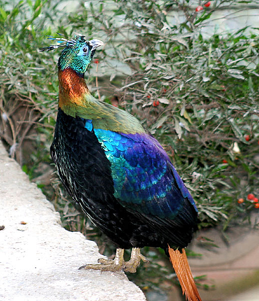
Image gallery
7 Images


Geography and climate
The country stretches across three main north–south ecological belts: the lowland Terai in the south, the hill region in the centre and the high mountain zone to the north. This altitudinal variation produces a wide range of climates—from subtropical in the Terai to alpine and polar conditions at the highest elevations—and supports diverse ecosystems. Major rivers originate in the mountains and flow southward into the plains, contributing to agriculture and hydropower potential.
Mountains, parks and biodiversity
Nepal contains many of the world’s highest mountains and an extensive network of protected areas. National parks and conservation areas safeguard species such as the one-horned rhinoceros, Bengal tiger and snow leopard in different ecological zones. Protected landscapes, including those around the Everest region and the Chitwan lowlands, attract scientists and tourists and play an important role in conservation and local livelihoods.
History and political development
The territory now known as Nepal was historically a patchwork of small kingdoms and principalities that were gradually unified under a central monarchy in the eighteenth and nineteenth centuries. After significant political change and a decade-long insurgency and negotiations, the monarchy was abolished and Nepal became a federal democratic republic in the early 21st century. The constitution and successive reforms established a secular state and a system of provinces with parliamentary institutions.
Government and administration
Nepal is governed through national and provincial bodies with local municipal and rural councils responsible for many public services. Decentralization and federal reforms have been major themes in recent governance debates, with ongoing efforts to strengthen institutions, improve infrastructure and expand public services across remote mountain and hill areas.
People, languages and society
The country is ethnically and linguistically diverse. Nepali is the official language and serves as a lingua franca, while dozens of regional languages and dialects are spoken across communities, including Indo-Aryan and Tibeto-Burman families. Many Nepalis also speak and study English and use Hindi for cross-border communication and commerce. Social life often centres on extended family networks, village communities and seasonal labour patterns.
Religion and culture
Religion plays a central role in public and cultural life. The majority of the population follows Hindu traditions and rites, while Buddhism remains an important faith for many and is interwoven with local practices. Nepal is widely recognized as the birthplace of Buddha, with the historic site of Lumbini attracting pilgrims. The country hosts many festivals, temples and pilgrimage routes that reflect centuries of religious and artistic exchange.
Economy and livelihoods
Nepal’s economy is mixed: agriculture employs a large share of the population, while services, tourism and small-scale manufacturing contribute to GDP. Remittances from Nepalis working abroad are a major source of household income and national foreign exchange. Tourism—especially trekking, mountaineering and cultural visits—supports jobs in mountain and urban communities, though development and infrastructure gaps remain in many regions.
Tourism, trekking and cities
Tourism centres on the country’s mountains, cultural heritage and natural scenery. Popular trekking regions include routes that begin near Pokhara and those leading to the Everest foothills. Kathmandu Valley contains historic palaces, temples and courtyards of high cultural value and serves as a hub for visitors. Lakes such as Phewa Tal near Pokhara and numerous rural homestays provide varied experiences for travellers.
Transport, education and health
Transport networks include a combination of road, air and limited rail links; mountain access often relies on footpaths and seasonal routes. Education and health services have expanded in recent decades but still face challenges in remote districts. The government and international partners work on improving schools, hospitals and rural connectivity.
Challenges and resilience
Nepal faces a range of development and environmental challenges: vulnerability to earthquakes and landslides, the effects of climate change on glaciers and water systems, and the need to balance conservation with community livelihoods. At the same time, local knowledge, community forestry programmes and tourism-based income provide sources of resilience for many mountain and rural populations.
Further information and key terms
Readers seeking more details can consult official publications, academic studies and travel guidance. Key terms and places mentioned in this article include:
- Nepali (language)
- South Asia (region)
- India (southern neighbour)
- China (northern neighbour)
- Mount Everest
- highest mountain (description of Everest)
- Himalaya
- Buddha (birthplace at Lumbini)
- Hindu (major religious tradition)
- kingdom (former political form)
- pilgrimage (religious travel)
- English (widely used second language)
- Hindi (regional cross-border language)
- Kathmandu (capital)
- Pokhara (tourism gateway)
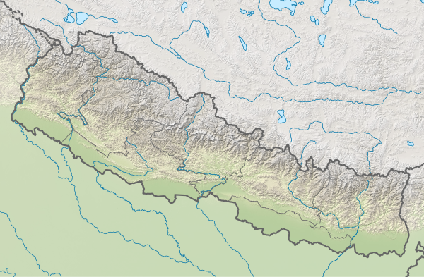
Geography
Location
Nepal is located in South Asia and stretches approximately from the 26th to the 30th parallel north and from the 80th to the 88th longitude east. Nepal covers an area of 147,516 square kilometers, of which about 143,000 square kilometers is land area and the remaining 4,000 square kilometers is inland water. The east-west extent is 885 kilometers, and the maximum north-south extent, which is reached in western Nepal, is about 241 kilometers. Nepal lies between Tibet to the north and India to the south. Nepal borders (from west to east) the Indian states of Uttarakhand, Uttar Pradesh, Bihar, West Bengal, and the former kingdom of Sikkim, which joined the Indian Union.
To the north and east lies much of the Himalayan mountain range, including Mount Everest, whose peak of 8848 metres is the highest point on earth. Seven of the other ten highest mountains on earth are also in Nepal. The lowest point, on the other hand, is 70 meters at Kencha Kalan in southern Nepal. This makes Nepal the average highest country in the world after Tibet; over 40% of the country's surface area is above 3000 metres.
Himalayas
The Himalaya is a relatively young folded mountain range in geological terms, at about 45 million years old, so it is less rounded and smoothed by erosion than other mountains. The rivers all eventually flow into the Ganges, but the largest rise north of the main Himalayan range and have carved antecedent through valleys during mountain uplift. That of the Kali Gandaki is with about 6000 meters - measured by the eight-thousanders Dhaulagiri (8167 m) and Annapurna (8091 m) facing each other there - the deepest valley of the earth.
This entire area is hardly populated and a popular destination for trekking tourists and mountaineers. From 1950 to 2005, 832 mountaineers had fatal accidents in the Nepalese Himalayas, about every hundredth expedition participant on mountains above 6000 meters.
See also: List of mountains and elevations in Nepal
Structure of the country
In terms of natural space, Nepal can be divided into three main regions, the southern Terai, the midlands and the high mountain region. This division is also linked to socio-economic, cultural and ethnic aspects.
|
|
The Terai
The Terai forms the Nepalese part of the Gangetic lowlands. Over the past 50 years, it has developed into an important economic and settlement area. Although the Terai accounts for only 14 % of the country's surface area, 47 % of the population live there. Fertile soils with little risk of erosion, a year-round frost-free climate and good irrigation possibilities make the Terai the most valuable agricultural region.
Almost all industrial settlements outside the Kathmandu Valley are also located in this plain. The Mahendra Highway runs through the Terai as the only road that provides an east-west connection. Nine domestic airports are located in the Terai and offer a direct flight connection with Kathmandu.
The midlands
The Siwaliks and the Mahabharata range form the transition from Terai to the midland, which reaches heights of up to about 3000 meters. The midland has a very highly structured relief. Factors such as microclimate, soils and geomorphology vary in the midlands over a small area, so that the conditions for settlement and agriculture also vary greatly. Nevertheless, the midlands represent the old settled heartland of Nepal. In the midlands, 45% of the population lives on 30% of the country's land area.
Due to the high relief energy, the midlands are highly hostile to road transport. For a long time, only the Kathmandu and Pokhara valleys had road access, with Kathmandu receiving road access only in the 1950s and Pokhara in the 1970s, Tribhuvan Rajmarg (Nepali: त्रिभूवन राजमार्ग) and Prithvi Rajmarg (Nepali: पृथ्वी राजमार्ग). The Mahendra Rajmarg (Nepali: महेन्द्र राजमार्ग), the first national longitudinal link from Mechinagar to Bhim Datta was gradually built in the Terai from the 1960s and was only completed continuously for a good 1000 km in 1996. Other parts of the midland were accessed from this road through spur roads, of which the Mechi Rajmarg (Ilam), the Dharan-Dhankuta Rajmarg, the Ratna Rajmarg (Birendranagar) and the Mahakali Rajmarg (Amargadhi) are the most important. Numerous other spur roads followed and the existing ones are being steadily extended northwards at full speed. At present, a longitudinal link is being constructed through the midlands, which has been completed in numerous sections but not yet in its entirety.
Kathmandu has the only international airport in the country. Pokhara is home to another major domestic airport.
The high mountain region
Almost all settlements of the high mountain region are concentrated in the valley areas. Summer settlements with pasture farming reach up to 5000 meters. The extremely high relief energy and the high monsoon precipitation (over 5000 millimetres) on the southern slopes contribute to soil erosion and make agriculture difficult.
In contrast, the northern sides of the main range, which are in the rain shadow, receive very little precipitation (less than 200 millimetres), so that agriculture is hardly possible. Forestry and silviculture are important pillars of subsistence farming in the mountains. Overall, the high mountain region is a food deficit area. The most important external source of income is tourism. There is so far only one spur road from the south, namely to Jomsom and Muktinath, though not yet developed. The only road crossing the high mountains in Nepal, and thus Nepal's only land link to China, is the Arniko Rajmarg (Nepali: अरनिको राजमार्ग) from Kathmandu to Tibet; however, it has been difficult to pass for years due to numerous landslides on the Tibetan side. The numerous airstrips and airfields scattered across the region provide an important transport link with the rest of the country; the most important of these are Jomsom, Jimikot, Dolpa and Lukla.
As a consequence, walking is still an important mode of transport, as it is in the Central Plateau. There is a tendency for the high mountain regions to be less developed than the rest of the country. In particular, in the western parts of the high mountain regions, the human development index is significantly lower than the national average. It deviates from the average by 15 %.
Hydrology
Nepal belongs predominantly to three basins of roughly equal size, namely those of the Karnali (headwaters of the Ghaghara in India), the Narayani (Narayani) and the Koshi. The Karnali drains most of western Nepal, the Narayani drains the central part of Nepal and the Koshi drains the eastern part of the country. The only river not included in these catchments is the Mahakali, border river in the west, which largely drains the Mahakali zone. All major rivers of the country flow directly or indirectly into one of the former three: Seti, Bheri, Western Rapti, Tila, Thuli Bheri, Humla Karnali, Mugu Karnali into the Karnali, Kali Gandaki, Seti Gandaki, Madi Khola, Marsyangdi, Budhigandaki, Trishuli, Bagmati and Eastern Rapti into the Narayani and Indrawati, Sunkoshi, Tamakoshi, Likhu Khola, Dudh Koshi, Arun and Tamor into the Koshi.

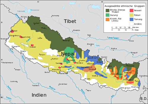
Population
Nepal is ethnically and culturally a mosaic of minorities. A 2001 census counted over 100 different ethnic groups and castes, and 124 different languages and dialects (most of which are in danger of extinction).
The Nepali caste system is still present as a social phenomenon, even though the rules are interpreted less strictly today and discrimination against individual castes was declared unlawful with the 1962 constitution, which spoke of a Hindu monarchy. Caste boundaries are partially permeable, furthermore the categories of ethnicity and caste overlap or depend on the perspective of the observer.
enlarge and show information about the picture
![]()
Ethnolinguistic groups in Nepal according to CIA data
Ethnography
The ethnic mosaic of Nepal consists mainly of Indo-Aryan and Tibeto-Burman ethnic groups. Many of the ethnic groups are descendants of refugees who had once retreated to Nepal.
For example, the Sherpa migrated to Nepal from the Chinese province of Sichuan from the east starting in 1500 AD. The origin of some ethnic groups is disputed or even unknown, for example that of the Newar or the Tharu.
The following table is intended to provide an overview of the seven largest population groups in Nepal:
| Nepal's most numerous ethnic groups/castes | |||
| Ethnicity | Percentage of total population | Original home in Nepal | ethnic group |
| Chhetri (Hill Kshatriya) | 16,6 % | across the country | Indo-Aryan |
| Bahun (Hill Brahmin) | 12,2 % | across the country | Indo-Aryan |
| Magar | 7,1 % | midwestern uplands | tibeto-burmese |
| Tharu | 6,6 % | western Terai | probably Tibeto-Birman, Indo-Aryan and Dravidian |
| Tamang | 5,8 % | Kathmandu valley and central hill country | tibeto-burmese |
| 5,0 % | Kathmandu Valley | tibeto-burmese | |
| Kami | 4,8 % | ||
The Gurung, Sherpa, Limbu and Rai ethnic groups are also worth mentioning.
44.6% of the total population are native Nepali speakers, according to the 2011 census. Other major languages are: Maithili (11.7%), Bhojpuri (6.0%), Tharu (5.8%), Tamang (5.1%), Newari (3.2%) and Bajjika (3.0%).
· 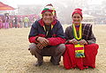
Married couple
· 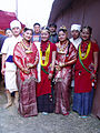
Folk dance group
· 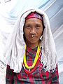
Younger Nepalese
· 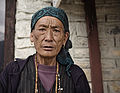
Elder Nepalese
See also: Meti, Kothi: Transwomen as the Third Sex in Nepal
Religion
According to the 2011 census, 81.34% of the population are members of Hinduism. Nepal was the only country where Hinduism was the state religion until the parliament embraced secularism after the king was deposed in April 2006. 9.04% of the population is identified as Buddhist (especially in Mustang). Lumbini, on the border with India, is traditionally believed to be the birthplace of Buddha. Larger minorities include 4.39% Muslims and 3.05% adherents of the Kirant Mundhum, an animist faith recognized as a religion.
The percentage of Christians in Nepal was 1.42% in 2011. In addition, there are 0.76% others. Christians include members of the Roman Catholic Church in Nepal (less than 0.1% of the population) and Jehovah's Witnesses. There are several Christian schools, especially in the Kathmandu Valley, which are also attended by Hindus or other religious followers due to their quality.
Other small minorities include Sikhs, whose numbers exceeded 7000 in 2011, and 4350 Bahai (2005 figures).
In the folk religion there are archaic elements of faith, which are very similar to those of classical Siberian shamanism. The Nepalese shamans still practicing today are partly admired, partly feared. Their characteristic is the so-called "trembling trance", which, however, is understood less as a shamanic journey of the soul than as a fight with the evil spirits; they are healers, but today primarily lecture artists. As an aid they use the stick drum dhyangro. Their sexual symbolism is striking. Most Nepalese also believe in gods and beings that are neither Buddhist nor Hindu in origin, but ancient nature deities that are found in trees, stones, birds, snakes and all kinds of animals, in mountains or in fire, but above all in water.
Nepalese caste system
The Nepalese caste system developed in parallel with the Indian one. Influence from India grew during the Gupta Empire (320 AD-500 AD); Nepal was considered a "neighboring kingdom" but was subject to tribute under Samudragupta.
The Nepalese Caste System from the Perspective of a Bahun or Chhetri
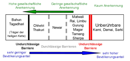
That in Nepal, as in most other states with caste systems, the caste of the untouchables is definitely one of the pillars of society can easily be seen from the fact that the Kami, the Damai and the Sarki alone, as the largest groups of the untouchables, already make up more than 7 % of the total population.
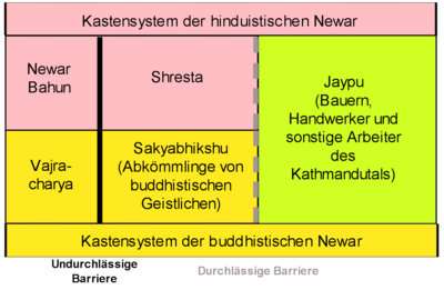
The caste system from the perspective of the Newars
Especially the Hindu Newars have their own caste system, which only includes the inhabitants of the Kathmandu valley. This system has also been partially adopted by the Buddhist Newars. In general, the caste system is weak in the egalitarian Newari community and could never establish itself there as strongly as it did among other ethnic groups.
Majority view of the caste system
The religious-ritual view accepted by the majority (liberal Bahun and Chhetri, ethnic groups without their own caste system) provides for a dichotomy:
- chokho jaat (pure box) and
- pani nachalne jaat (untouchable boxes)
In practice, caste is sometimes also linked to wealth, which means that poorer inhabitants tend to be assigned to the untouchables, richer ones to the upper castes. This leads to the fact that European foreigners, who as non-Hindus should actually be untouchables, are usually counted among the upper class and are only treated as untouchables for acts of strong ritual significance. This includes, for example, all those actions that have to do with water and the preparation of rice.
Cities
The population of Nepal remains largely rural and peasant to this day; the proportion of urban dwellers remains one of the lowest in the world at 15% of the total population. However, urbanization has increased sharply in recent years, with growth rates in this area of 3.5 % per year and higher.
Nepal was governed centrally down to the local level until the early 1990s. In the course of democratisation and decentralisation, the municipalities were made independent in several stages. The "city rights" with the title "Nagarpalika", "Up-Maha-Nagarpalika" and "Maha-Nagarpalika" are thus granted by the government.
Except for Kathmandu, all cities lack resources to a greater or lesser extent, and self-government is therefore difficult to implement. In addition, there are still strong centralist structures in the state administration, which contradict the desired local self-government.
Depending on the size and financial strength of the municipality, there are three different degrees of self-government. The Maha-Nagarpalika receives the most powers; there is only one city of this category in Nepal: Kathmandu. The next level is the Up-Maha-Nagarpalika, such as Lalitpur or Pokhara; in total there are four of them. The lowest of the three levels is the Nagarpalika.
Other conditions for independence, such as certain infrastructural facilities or road connections, are not met in many cases, at least not all year round. There are regional planning and political reasons why these municipalities have been made independent. In this light, the statistical urban population of Nepal can be safely reduced by about half a million to get an idea of the actual degree of urbanization in the country.
The three largest cities are in the mountains, but the majority of municipalities are in the Terai. The remaining municipalities in the mountains are often very small mountain towns, which, with the addition of surrounding villages, have a population of approximately 20,000. The fact that a number of them are not urban centres is also shown by their comparatively small growth rate.
In addition to the high rate of rural exodus, Nepal is experiencing a shift in population from the mountains to the Terai. More than half of the country's population already lives in this lowland strip along the border with India, and most of the new cities are currently being built there.
The largest population centre was and still is the Kathmandu Valley with the double city Kathmandu/Lalitpur (Patan), the smaller neighbouring city Bhaktapur and some small towns like Madhyapur Thimi and Kirtipur. This metropolitan area also includes a few smaller towns near the valley, namely Banepa, Dhulikhel and Panauti. The Kathmandu valley is largely urbanized and its complete, almost always unplanned, capture as a settlement area is foreseeable. The Kathmandu area today has a population of just over 1.5 million.
The second major population centre in the mountains, which also has above-average growth rates, is the Pokhara Valley with the towns of Pokhara and Lekhnath, whose populations have already exceeded the 200,000-population mark. Otherwise, there are only a few smaller towns worth mentioning scattered in the mountain regions (from east to west):
- Ilam
- Dhankuta
- Bhimeshwar
- Gorkha (formerly Prithvinarayan)
- Tansen
- Putalibazar
- Ghorahi (formerly Tribhuvannagar)
- Tulsipur
- Birendranagar
- Dipayal Silgadhi
In addition, the country's other major cities are located in the Terai (from east to west):
- Mechinagar
- Biratnagar
- Dharan
- Itahari
- Rajbiraj
- Triyuga
- Janakpur
- Birganj
- Hetauda
- Bharatpur
- Ramgram
- Butwal
- Siddharthanagar
- Nepalganj
- Gulariya
- Tikapur
- Dhangadhi
- Bhim Datta (formerly Mahendranagar)
The name changes of some towns in recent times are due to the fact that the local authority was given a new name upon incorporation. Prominent examples of this are the better known town of Gorkha, the municipality was officially called Prithivinarayan until 2009, but was then renamed after the core town of Gorkha. The old royal city of Patan near Kathmandu is now officially called Lalitpur. However, the old names are still in use.
See also: List of cities in Nepal
Education
- 96,000 students
- 3.47 Students per 1000 inhabitants
- Education Expenditures: $224,732,300
- Education spending per capita: $8
- Illiteracy rate: 35.3 % (women: 44.9 %, men: 24.4 %) as of 2015
The Nepalese government is in the process of restructuring the education system. Access to primary (grades 1 to 8) and secondary (grades 9 to 12) schools is to be expanded and vocational training measures introduced in the upper grades. It is being supported in these measures by an EU cooperation programme; from 2008 to 2011, support funds worth 43 million euros flowed in.
Healthcare
In 1999, Nepal had 923 doctors, 5,500 nurses and about 13,000 health workers. There were a total of 4124 beds in 83 hospitals. Infant mortality has been greatly reduced. In 1950, 34% of children died before their 5th birthday; in 2017, the figure was 3%. In 2000, maternal mortality was 0.8%. Life expectancy between 2010 and 2015 was 68.9 years (men: 67.4 years, women: 70.5 years). Strong progress was made in increasing life expectancy and improving other health indicators.
Development of life expectancy
| Period | Life expectancy in years |
| 1950–1955 | 34,0 |
| 1960–1965 | 36,2 |
| 1970–1975 | 42,0 |
| 1980–1985 | 48,3 |
| 1990–1995 | 56,4 |
| 2000–2005 | 64,0 |
| 2010–2015 | 68,9 |
| 2015–2020 | 70,8 |
Source: UN


Questions and answers
Q: What is Nepal?
A: Nepal is a country in South Asia located between India and China.
Q: What mountains are in Nepal?
A: Mount Everest, the highest mountain in the world, and the Himalaya Mountains are both located in Nepal. Additionally, 12 of the world's highest mountain peaks can be found in Nepal.
Q: Who was born in Nepal?
A: Buddha was born in Nepal.
Q: What is the religion of Nepal?
A: Although it has recently become a secular country, before that it was the only Hindu kingdom in the world. It is also an important pilgrimage place for both Hindus and Buddhists.
Q: How many people live in Nepal?
A: In 2007, there were almost 29 million people living in Nepal.
Q: What languages are spoken by people from Nepal?
A: Nepali is the official language of the country, but there are also many other regional languages spoken by people from different parts of Nepal. Additionally, many people understand English and Hindi as well.
Q: What cities are located within NepaL? A: The capital city of Nepal is Kathmandu which has a population of over 1.4 million people while Pokhara is its second-largest city with natural beauty including lakes such as Phewa Tal being major tourist attractions
Related articles
Author
AlegsaOnline.com Nepal: Geography, History, Culture and Modern State Leandro Alegsa
URL: https://en.alegsaonline.com/art/69177
Sources
- ice.tsu.ru : Glacial Lakes and Glacial Lake Outburst Floods in Nepal. - International Centre for Integrated Mountain Development, Kathmandu, March 2011
- ethnologue.com : "Nepal"
- cbs.gov.np : "National Population and Housing Census 2011 (National Report)"
- nepjol.info : "Religious Syncretism and Context of Buddhism in Modern Nepal"
- royalark.net : "Nepal5"
- kathmandupost.com : kathmandupost.com/national/2020/05/20/government-unveils-new-political-map-including-kala…
- thehimalayantimes.com : thehimalayantimes.com/nepal/govt-officially-unveils-new-political-map-incorporating-limpi…
- esa.un.org : "World Population Prospects: The 2017 Revision"
- imf.org : "Nepal"
- data.worldbank.org : "Gini Index"
- hdr.undp.org : "Human Development Indicators - Nepal"
- barnesandnoble.com : History and Geography