Neckar — river of southwestern Germany
The Neckar is a 367 km river in Baden-Württemberg, rising in the Black Forest and flowing north to join the Rhine at Mannheim. It shaped regional industry, transport, viticulture and historic towns along its valley.
Overview
The Neckar is a major river in southwestern Germany, about 367 km long. It rises in the mountainous woodlands of the Black Forest and flows generally northward through the state of Baden-Württemberg before joining the Rhine at Mannheim. In local dialects it is sometimes called the Negger. The river and its valley are important for transport, industry, agriculture and cultural history in the region.
Image gallery
10 Images


Course and characteristics
The Neckar descends from upland springs and carves a varied corridor: steep, forested upper reaches, narrower gorges through the Odenwald hills, and a broader, more managed lower valley approaching the Rhine. A network of weirs, locks and river engineering works has long made parts of the river navigable and more suitable for industrial use. Along its length the river receives numerous smaller tributaries and passes through a sequence of terraces that support vineyards and settlements.
Major towns and landmarks
- Tübingen — a historic university town located on a meander of the Neckar.
- Nürtingen — a regional market and small industrial centre.
- Esslingen — noted for medieval architecture on the riverbanks.
- Stuttgart — the state capital whose metropolitan area reaches into the Neckar basin.
- Heidelberg — world-famous for its castle and riverside old town.
- Mannheim — where the Neckar meets the Rhine, creating a busy confluence region.
History, economy and culture
For centuries the Neckar was a natural artery for local commerce, connecting inland towns with larger Rhine trade routes. The valley supported milling, small-scale manufacturing and, more recently, larger industrial plants and inland shipping. Vineyards on the sunny slopes of the Neckar valley have produced wines for many generations and contribute to regional identity. The river corridor is also rich in historical sites: castles, old bridges and university towns whose development was shaped by proximity to the waterway.
Ecology and recreation
Despite industrial use, stretches of the Neckar retain ecological value. Floodplain woodlands, reed beds and side channels provide habitat for fish, birds and amphibians. River management and environmental programmes aim to balance navigability and flood control with habitat restoration. The Neckar is popular for recreational boating, cycling along well-developed river paths and riverside tourism, especially in scenic sections between vineyards and historic towns.
Notable facts and distinctions
The Neckar differs in character from the larger Rhine: it is shorter, winds through more pronounced hills and has a valley with intensive viticulture and many medieval settlements. Its course has been substantially altered by locks and embankments to serve navigation and flood protection, yet it remains a focal feature of Baden-Württemberg's landscape and cultural heritage.
Name
The name Neckar is of Celtic origin and means violent, evil, fast river. It derives from the primeval European word nik, which means to storm off. The development of the name begins in pre-Christian times with the name Nikros, which via Nicarus and Neccarus became Necker and finally the current word Neckar. The river Necker, a tributary of the Thur in northeastern Switzerland, has an almost identical name development.
Geography
River
Source
The headwaters of the Neckar are located in the Schwenninger Moos between Schwenningen and Bad Dürrheim. The traditionally designated source of the river is located in the Möglingshöhe city park in Schwenningen. Before the State Garden Show Villingen-Schwenningen 2010, the Neckar was largely silted up within the urban area of Schwenningen. In order to better protect the town against recent frequent flooding caused by overflowing of the river, more reservoir space and a mostly new open streambed were created for the river from its source in the course of the State Horticultural Show, which runs largely within the newly laid out horticultural show grounds.
Upper reaches
Until shortly before Rottweil, the Neckar is still only a small stream on the plateau of the Baar. In Deißlingen-Lauffen it had its only waterfall, four metres high, which is now drained. After that, the Neckar joins the Eschach, which flows from the Black Forest eastern plateau and carries considerably more water. Its main source, the Glasbach, which rises at the Brogen, is, from a hydrographical point of view, the main river of the Neckar river system.
With this confluence above Rottweil, the Neckar enters a narrow, wooded valley and then makes its way north for the next 80 km between the mountain ranges of the Black Forest and the Swabian Alb. North of Rottweil, it has created two circulating mountains near the Neckarburg, between which the A 81 spans it on the Neckarburg Bridge. Further downstream, the old town of Oberndorf lies high above the Neckar on a limestone terrace that fills one of the basin-like side valleys. At Horb it turns northeast in front of the Gäuplatte and then flows in its direction in front of the Albtrauf. At Weitingen the valley is spanned by the 127 m high Neckartal bridge of the A 81. Near Rottenburg it enters the Tübingen valley widening. Behind Tübingen the valley narrows again. From here on, the surrounding plateaus are much more densely populated.
Middle course
At Plochingen, the Neckar turns sharply to the northwest at the "Neckarknie" at the mouth of the Fils, which flows in from the Alb on the right. From here on, it is developed as a shipping route and runs to Stuttgart in a wide, urbanized floodplain, interspersed with traffic buildings and covered with industry, which is only briefly interrupted by large parks in the area of the Cannstatt valley bend. Here, too, the valley margins show calcareous sinter formations.
Behind Stuttgart it takes again the general direction to the north. In a winding and narrow valley section through the district of Ludwigsburg, the Rems flows towards it from the right at Remseck, then the Murr also from the right north of Marbach; after passing the Hessigheim rock gardens, it then reaches the water-rich Enz from the left at Besigheim. The former rapids at the Lauffener Mäanderhalsdurchbruch is today over dammed. In the lowlands around Heilbronn, the Neckar then runs through an open landscape in a wide floodplain. At Bad Friedrichshall, over a distance of only two kilometres, it takes in two of its other major tributaries one after the other from the right: first its most water-rich tributary, the Kocher, and shortly afterwards its officially longest, the Jagst, which together roughly doubles its water flow.
Underflow
Between Bad Wimpfen with its Stauferpfalz and Mosbach, the Neckar enters the Odenwald, where once again high, forested slopes line its banks in a gorge-like valley and deeply incised valleys flow into it, especially on the right. At the last of its prominent knees near Eberbach, it bends to the west, briefly enters Hessian territory near Hirschhorn and then forms the state border between Baden-Württemberg and Hesse for long stretches as far as Neckarsteinach. At Neckargemünd, the Elsenz flows in from the left, its lower course using the downstream part of the former Maurer Talschlinge, which stretches far to the south and was left behind by the Neckar after a meander breakthrough. Near the city of Heidelberg, which borders the Odenwald to the north and the Königstuhl massif to the south, the Neckar valley is cut deepest between mountains over 400 metres high on both sides. After passing the old town of Heidelberg, the river enters the wide Upper Rhine lowlands and, after another 25 kilometres or so, flows into the Rhine from the right in Mannheim, roughly in the middle of the Rhine.
Tributaries
→ Main article: River system of the Neckar and List of tributaries of the Neckar
For discussion of the "true source" of the Neckar see in the previous section.
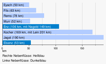
The largest among the tributaries of the Neckar are the Enz with the largest catchment area, the Kocher with the highest mean water flow and the Jagst with the greatest length. The Kocher tributary Lein is not only longer at the confluence than the headwaters of the Kocher there, but also has more water; according to hydrographical convention, the Lein would thus be regarded as the main river of the Kocher system, which, with 201 kilometres of longest flow path, then exceeds that of the Jagst.
Diagram of tributaries with 50 km length and more
Tributaries with 20 km length and more
Enumerated from the official source to the mouth. According to LUBW-BRSWEB, LUBW-FG10, LUBW-GEZG and TK25. Catchment sizes mostly according to LUBW-GEZG, otherwise measured on the background map. Length preferably according to the data sets of LUBW-FG10, rarely measured on the background map. Names preferably according to TK25.
- Eschach (left tributary near Rottweil-Bühlingen, 38.1 km)
- Prim (right tributary near Rottweil, 21.1 km)
- Schlichem (right tributary near Epfendorf, 34.4 km)
- Glatt (left tributary near Horb-Neckarhausen, 34.2 km)
- Eyach (right tributary at Eyach station, municipality of Eutingen im Gäu, 50.4 km)
- Starzel (right tributary at Rottenburg-Bieringen, 42.8 km)
- Steinlach (right tributary near Tübingen, 25.1 km)
- Ammer (left tributary near Tübingen-Lustnau, 22.5 km)
- Echaz (right tributary near Kirchentellinsfurt, 22.8 km)
- Erms (right tributary near Neckartenzlingen, 32.7 km)
- Aich (left tributary near Nürtingen-Oberensingen, 30.4 km)
- Lauter (right tributary near Wendlingen, 25.7 km)
- Fils (right tributary near Plochingen, 62.8 km)
- Körsch (left tributary west of Deizisau, 26.3 km)
- Rems (right tributary near Remseck, 78.4 km)
- Murr (right tributary near Marbach, 51.5 km)
- Enz (left tributary near Besigheim, 105.5 km)
- Zaber (left tributary near Lauffen, 22.4 km)
- Schozach (right tributary near Heilbronn-Sontheim, 25.6 km)
- Lein (left tributary near Heilbronn-Neckargartach, 27.3 km)
- Sulm (right tributary near Neckarsulm, 26.2 km)
- Kocher (right tributary at Bad Friedrichshall-Kochendorf, 168.7 km)
- Jagst (right tributary at Bad Friedrichshall-Jagstfeld, 190.2 km)
- Elz (right tributary near Mosbach-Neckarelz, 39.8 km)
- Itter (right tributary in Eberbach, 28.0 km)
- Laxbach (right tributary near Hirschhorn, 30.0 km with longest headwaters)
- Steinach (right tributary near Neckarsteinach, 21.9 km)
- Elsenz (left tributary near Neckargemünd, 53.4 km)
Towns and communities on the Neckar
The Neckar touches the districts, cities and municipalities listed below in the order from source to mouth:
- Black Forest-Baar District:
Villingen-Schwenningen, Dauchingen - District of Rottweil:
Deißlingen, Rottweil, Villingendorf, Epfendorf, Oberndorf am Neckar, Sulz am Neckar - County of Freudenstadt:
Horb am Neckar, Eutingen im Gäu (Weitinger Mühle)... - District of Tübingen:
Starzach (districts of Börstingen and Sulzau), Rottenburg am Neckar, Tübingen, Kirchentellinsfurt - County ofReutlingen:
Reutlingen (Altenburg, Oferdingen and Mittelstadt districts), Pliezhausen - County Esslingen:
Neckartenzlingen, Neckartailfingen, Nürtingen, Oberboihingen, Unterensingen, Wendlingen am Neckar, Köngen, Wernau (Neckar), Plochingen, Deizisau, Altbach, Esslingen am Neckar - Stuttgart (city district):
Districts of Obertürkheim, Hedelfingen, Wangen, Untertürkheim, Stuttgart-Ost, Bad Cannstatt, Münster, Hofen, Mühlhausen - Rems-Murr district:
Fellbach (Oeffingen district) - County Ludwigsburg:
Remseck am Neckar, Ludwigsburg (districts Poppenweiler, Hoheneck and Neckarweihingen), Marbach am Neckar, Benningen am Neckar, Freiberg am Neckar, Pleidelsheim, Ingersheim, Mundelsheim, Hessigheim, Besigheim, Walheim, Gemmrigheim, Kirchheim am Neckar - Heilbronn district:
Neckarwestheim, Lauffen am Neckar, Talheim, Nordheim - Heilbronn (city district):
districts of Horkheim, Klingenberg, Böckingen, Sontheim, Heilbronn, Neckargartach - Heilbronn district:
Neckarsulm, Untereisesheim, Bad Friedrichshall, Bad Wimpfen, Offenau, Bad Rappenau (Heinsheim district), Gundelsheim - Neckar-Odenwald district:
Haßmersheim, Neckarzimmern, Mosbach (districts of Neckarelz and Diedesheim), Obrigheim, Binau, Neckargerach, Zwingenberg - Rhine-Neckar district:
Eberbach, Schönbrunn (Baden) - Bergstrasse district (Hesse):
Hirschhorn (Neckar), Neckarsteinach - Rhine-Neckar district:
Neckargemünd - Heidelberg (city district):
districts Schlierbach, Ziegelhausen, Neuenheim, Altstadt, Bergheim, Wieblingen - Rhine-Neckar district:
Dossenheim (Schwabenheim district), Edingen-Neckarhausen, Ladenburg, Ilvesheim - Mannheim (City District):
Districts of Seckenheim, Feudenheim, Neuostheim, Oststadt, Neckarstadt-Ost, Innenstadt/Jungbusch, Neckarstadt-West


Related articles
Author
AlegsaOnline.com Neckar — river of southwestern Germany Leandro Alegsa
URL: https://en.alegsaonline.com/art/68961