Nauru: Small Pacific Republic — Geography, History, Economy, and Society
Nauru is a tiny island republic in Micronesia, historically shaped by phosphate mining. This article covers its geography, history, economy, governance, society and environmental challenges.
Nauru is a sovereign island state in the central Pacific Ocean located within the wider cultural region of Micronesia and the South Pacific. Covering about 21 square kilometres, it is one of the smallest independent countries in the world and has a population of roughly ten thousand people. The island lies near Banaba in the Republic of Kiribati.
Image gallery
10 Images


Overview and key characteristics
Nauru is a raised coral island whose interior was heavily altered by decades of phosphate extraction. It has no official capital; the district of Yaren functions as the main administrative centre. Because of its tiny land area and population it is frequently listed among the smallest states, alongside entities such as the Vatican City and Tuvalu, and is described in reference works as the world’s smallest island republic and one of the least-populated independent countries (smallest independent republic).
Geography and environment
Physically, Nauru consists of a narrow coastal belt where most settlement and infrastructure lie and a raised phosphate plateau in the centre. Mining removed much of the island’s original topsoil and vegetation, leaving scarred limestone pinnacles across much of the interior. Freshwater is scarce, soils are poor, and the island is exposed to the risks common to low-lying Pacific states, including sea-level rise and extreme weather.
History and development
The island was settled in prehistoric times by Pacific peoples. In the late 19th century Nauru came under German colonial control; after World War I it was administered by Australia, New Zealand and the United Kingdom under a League of Nations mandate and later a United Nations trusteeship. Phosphate mining began commercially in the early 20th century and became the dominant economic activity, profoundly shaping the island’s society and statehood before Nauru achieved independence in 1968.
Economy and contemporary issues
For much of the 20th century phosphate exports generated high per-capita revenues. Over-extraction and limited reserves produced boom-and-bust cycles: by the late 20th century resources were largely depleted and economic difficulties followed. Since then the economy has diversified modestly into services such as fishing licence sales, small-scale commerce, and providing facilities under bilateral arrangements with other countries. Phosphate mining and its legacy remain central to discussions about land rehabilitation, sustainable livelihoods and national finances (phosphate).
Government, language and society
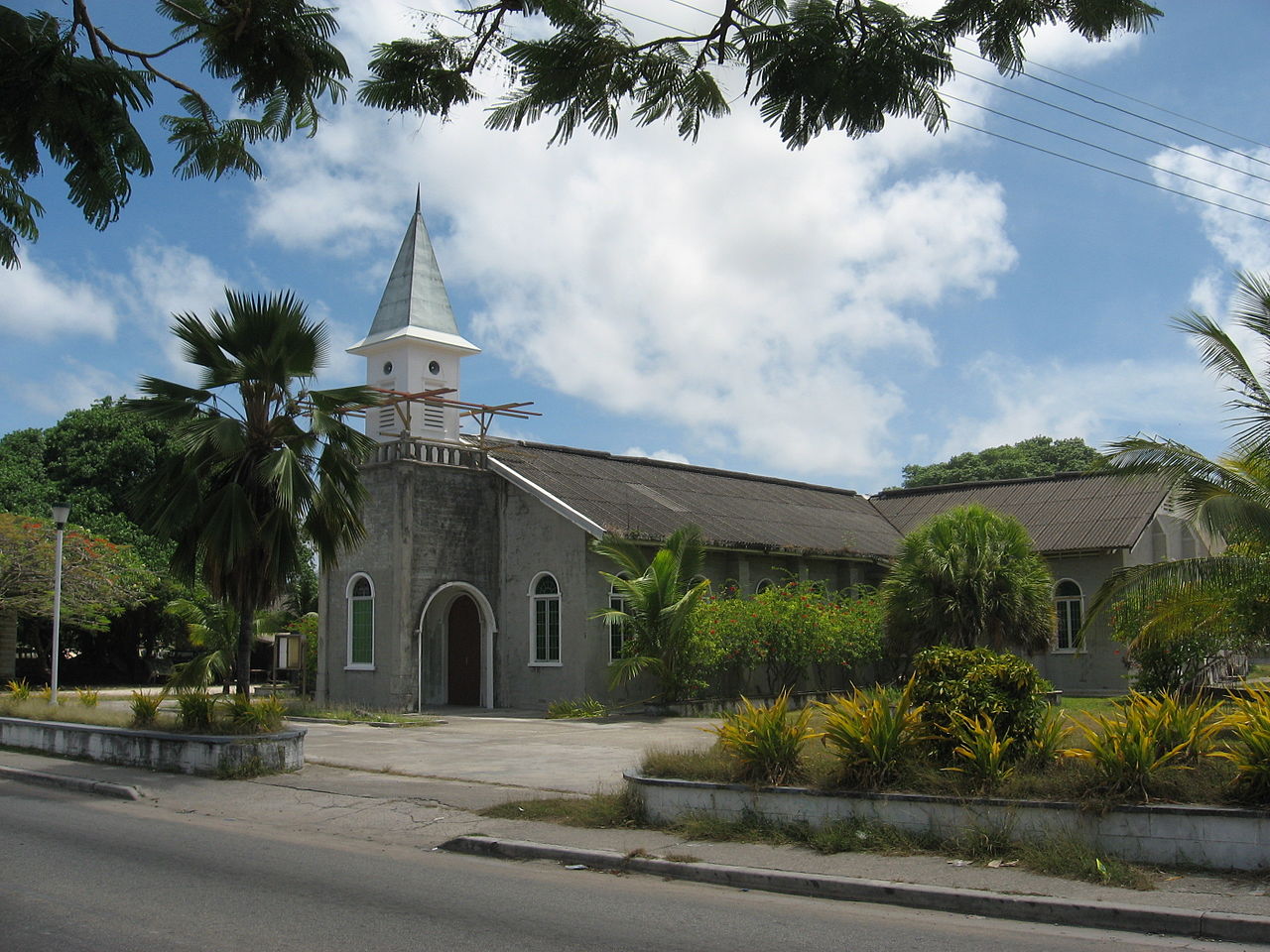
Nauru is a parliamentary republic in which the president is elected by the members of parliament and serves as both head of state and government. The Nauruan language and English are used in public life, education and government affairs (English is widely used). Christianity is the predominant religion and communal ties are important in daily life. The small population, limited land area and dependence on a narrow economic base shape public policy, planning and international relations.
Notable facts and ongoing challenges
- Nauru’s environmental recovery from phosphate extraction is an ongoing technical and financial challenge.
- The country’s size and resource constraints make it sensitive to external economic shifts and climate impacts.
- Despite being tiny, Nauru plays a distinct role in regional diplomacy and maintains sovereignty as an independent republic.
For further general reference about the region, see materials on administrative centres and compact discussions of small island states in the Pacific (Micronesia, South Pacific).
Etymology
The origin of the word "Nauru" is not clear. The Nauruans used to call their island "Naoero", as they do today. The German Paul Hambruch, who visited the island in May 1909 and from September to November 1910, gave the etymological explanation that "Naoero" must be interpreted as a contraction of the phrase "ã-nuau-a-a-ororo" (would be written "A nuaw ea arourõ" today), which means something like "I go to the beach". The Deutsches Koloniallexikon (1920) then also adopted Hambruch's explanation with the word "Anáoero" or "Ānā́ọĕṙọ". Alsatian Catholic missionary Alois Kayser, MSC, who missioned on Nauru for more than 30 years and studied the Nauruan language extensively, rejected Hambruch's explanation because in Nauruan the word "beach", as the target of a verb of movement, requires the directional word "rodu", meaning "downhill", and gives the term "rodu aröüro" for "to go to the beach". Nauruians consider the beach to be the lowest point of the island geographically - both in terms of land and sea. The fact that "rodu" is missing from Hambruch's explanation of the word makes his etymology of the word "naoero" and thus of "Nauru" untenable.
The island also had other names: The English colonialists before 1888 called it Pleasant Island or Shank Island, and the German colonial rulers called it Nawodo or Onawero. The word "Nauru" was later created from "Naoero" so that Europeans and Americans could pronounce the island's name correctly.
Geography
Geology and climate
The island lies in the western Pacific Ocean at 0° 32′ south latitude and 166° 56′ east longitude. The nearest island is Banaba 290 km to the east, which belongs to Kiribati and which had a similar importance because of rich phosphate deposits (the third important phosphate island in the Pacific is Makatea in the Tuamotu Archipelago). Nauru has an Exclusive Economic Zone of 308,480 km² (including territorial waters of about 570 km²), bordering the corresponding zones of Kiribati to the east (290 km to Banaba Island) and of the Marshall Islands to the north (600 km to Ebon Atoll). More distant neighbors are Micronesia (Kosrae) to the northwest, the Solomon Islands to the southwest, Papua New Guinea (Bismarck Archipelago) to the west and Tuvalu to the southeast.
Nauru is an uplifted atoll on top of an extinct undersea volcano. The huge coral stock extends about 2000 metres into the sea and rises a maximum of about 60 metres above sea level. This highest point is located in eastern Aiwo along a plateau edge called Command Ridge. Compared to other atolls, Nauru has a very small lagoon. One kilometer from the coast, the sea depth is already more than 1000 meters, and the island shelf drops steeply to a depth of about 4300 meters. Except for a narrow coastal strip, the inner part of the island was covered by phosphate (nauruit) formed from the excrement of sea birds. About two square kilometres of the island are forested.
· 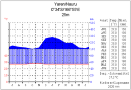
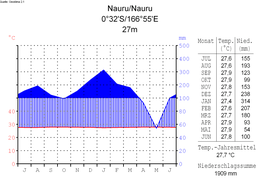
Climate diagram Yaren
· 
Nauru Climate Chart
· 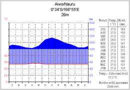
Climate diagram Aiwo
Due to Nauru's location very close to the equator, temperatures are balanced all year round with a monthly average temperature of about 27.5 °C. The trade winds bring year-round precipitation to the island, which averages 1900 mm per year. Agriculture is made much more difficult by the porous limestone, as the water seeps away very quickly.
With regard to rising sea levels caused by climate change, the government has already made several representations to the UN on the urgency of the matter and called for some meetings with the US and other developed nations.
flora and fauna
There are no large animals on Nauru: Apart from insects, it is only home to various species of seabirds, such as the banded frigatebird. There is only one species of songbird, the Nauru warbler (Acrocephalus rehsei), which is endemic here. Common stray pets such as cats, dogs and pigs have been introduced by the population from abroad.
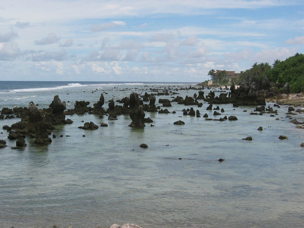
Around the island runs a wide shallow water fringe, which dries at low tide and can be walked on; here lives a variety of marine life such as sea urchins, molluscs and crabs, and corals also grow in the shallow water in front of it. Connected to this fringe is a narrow strip of land a few hundred metres wide with snow-white coral sand, where coconut palms, screw trees and other woods thrive. Along the entire coast, where almost all the buildings of the island are located, runs the main road.
Further inland rises a second high terrace, on which the natural landscape is still largely preserved. Here, sparse forests with coconut palms, fig trees, rosewood (locally called Tomano), hibiscus extend. Other tree species such as cherries, almond trees or mango trees have fallen victim to intensive deforestation and environmental destruction. Remarkable in the interior of the island is the difference between the now mined phosphate areas and the still somewhat preserved natural landscape. While the vegetation is somewhat denser and lower at lower altitudes, there are more hardwood trees around the highest points of the island. This difference can be explained by the absence of rainwater runoff into the ocean. It quickly seeps into the porous limestone and phosphate soil, the bottom of which (and therefore the water table) is low.
Of the 493 plant species (including hybrids) on Nauru, only 59 are believed to be native, and none endemic.
Coral
A large number of molluscs and crustaceans live on the coast and immediately in front of it, as well as blue corals with their shimmering blue calcareous skeleton. These are considered living fossils and are the only representatives of the family Helioporidae from the order Octocorallia. They are rare and only occur in marine areas around the equator where the water temperature does not fall below 24 °C.
Geology
→ Main article: Geology of Naurus
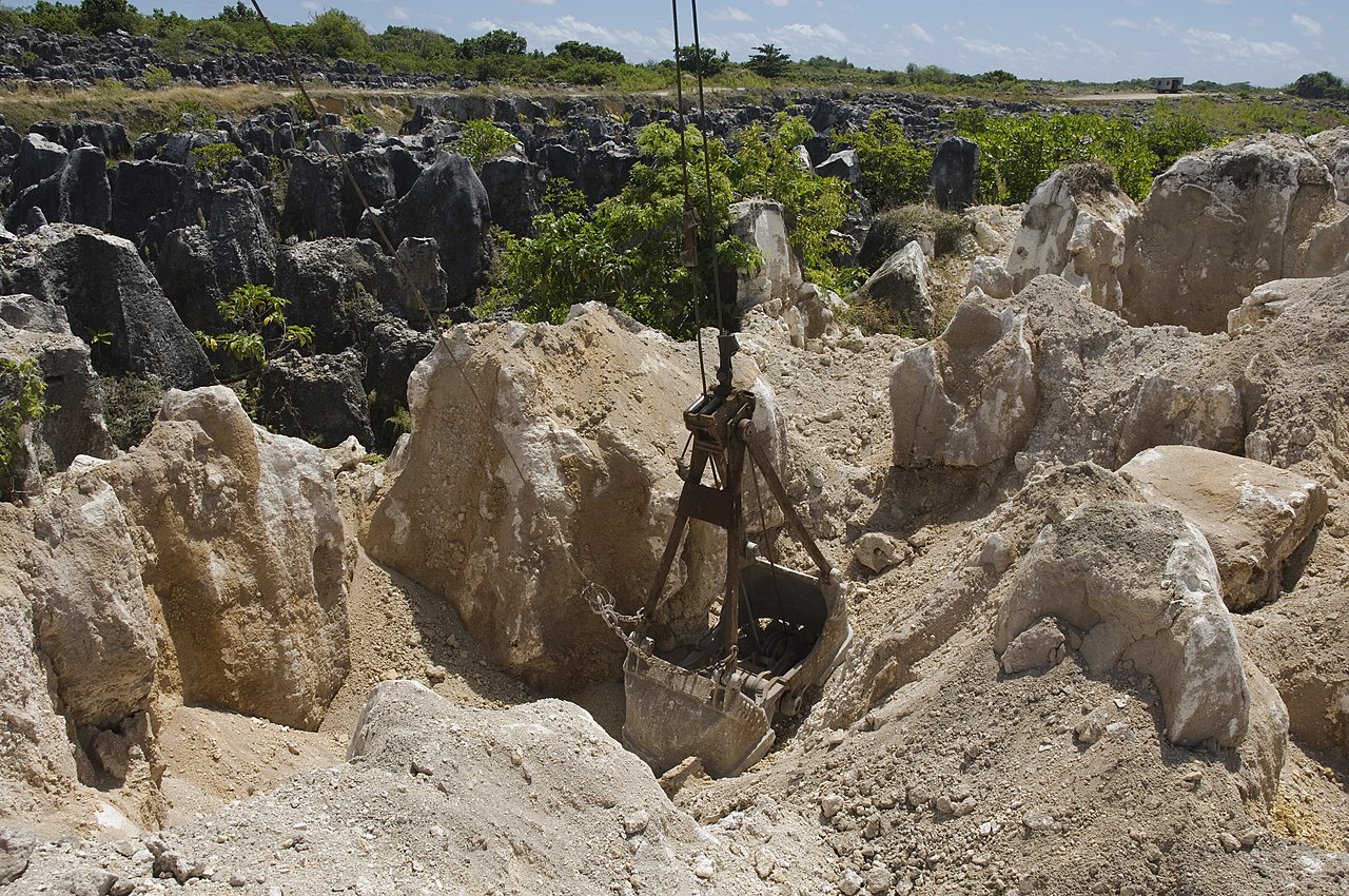
The most remarkable part in the interior of the island are fantastic-looking limestone pinnacles and pyramids formed in the exploited phosphorite open-cast mines. They are four to ten meters high, and between them has formed a whole maze of cauldrons and deep hollows.
The rest of the island is an almost flat table. The phosphate mined by excavators was taken away by a narrow-gauge railway. A peculiar, inanimate moonscape remained. The stone pinnacles and pyramids have no ground cover and are devoid of vegetation. Rainwater runs into the hollows and quickly seeps away through the porous reef limestone.
Geographers, geomorphologists and geologists studied the relief, soil and geological structure of the island and deduced a very varied history of development: Nauru Atoll has existed for a very long time. The ring-shaped fringing reef of Tertiary corals has survived to the present day. In the Paleogene, the Old Tertiary, the floor of Buada Lagoon was 60 meters below present sea level. In the Miocene, a period of the Late Tertiary, the atoll was strongly uplifted so that the bottom of the lagoon was ten meters higher than the present sea level. It is likely that the surface of the island underwent severe erosion during this period, forming a karst relief. These are the stone jags and pyramids of today that give the open pits such a strange appearance. Subsequently, the island was flooded and a shallow water lagoon formed. Sediments enriched with phosphorus settled in the hollows and other cavities between the jags of the reef limestone. Flooding of the island continued for a long time. During this time, the lagoon sediments underwent considerable changes that may have contributed to the dissolution of the carbonates contained in the sediments and to the enrichment of the sediments with phosphorus compounds.
Thereafter, a prolonged period of uplift of the island occurred, the bottom of the former lagoon rose from the water, and plants began to colonize the island. At present, the entire inner part of the island is twenty to thirty meters above sea level. Only a small depression remains, which is occupied by a lake - the Buada lagoon.
This picture of Nauru's geological history contains two controversial points:
The explanation given for the formation of the peculiar relief is somewhat doubtful. Apart from the assumption that there has been a strong karstification, that is, that the reef limestones have been dissolved, there is another opinion: On the beach and in the stony shallows, especially on the eastern side of the island, there are quite a few small stone pillars preserved as "witnesses". They are strangely shaped and have formed as a result of the destruction of the reef massif by the ocean waves. One can imagine that the entire shallow water part of the island's surface was subjected to intense working by the waves during periods of uplift. This space was not protected, in any case there have been very wide passages in the ring-shaped reef. The further uplift of the island then merely resulted in the continuation of the preceding outwash, with the rainwater smoothing out the stone pillars and stone jags that remained as remnants.
The second controversial point is the formation of the phosphorites. In the open pits and in places where the so-called nauruit comes to light, one can see that the layer of phosphorite sediments is built in a complicated way. Most typical is the picture of fragmented debris of various sizes: sometimes crusts and clods of a meter in diameter, mostly smaller angular pieces of debris, more rarely abraded phosphorite kidneys mixed with fine earth. All this material is unsorted and very diverse. Accordingly, the original accumulation of phosphorite, which usually forms in shallow water after the death of large plankton masses, has been repeatedly reshaped during severe erosion and multiple redepositions.
In the complicated and long history of the island, there have undoubtedly been periods when strong typhoons passed over it. Then a very intensive washing out and rearrangement of the debris took place. Such catastrophic changes have also been described from present-day atolls. In each case it is then pointed out that huge masses of debris material were redeposited and reshaped on the island and in the shallow water on the coast. In this process the fine earth was carried out to the open sea, while the larger pieces, chiefly nodules of phosphorite and fragments of crusts formed by dropping, remained on the island. Rubble and fragments were held in the hollow forms of the relief, and in a karstified relief they filled especially the hollows and pockets between the jags and pyramids of reef limestone.
There is another version of the formation of the phosphate rock, which is considered more probable: In the easily soluble limestone, exposed to weathering, deep funnels and pointed cones formed at the surface, ideal nesting sites for seabirds. Over hundreds of thousands of years, the excrement of millions upon millions of seabirds accumulated in the funnels, eventually covering almost the entire island by meters. The guano, as the deposits of bird excrement are called, transformed over time under the influence of the weather into calcium phosphate of the highest purity. The rock sometimes contained over 90 % pure phosphate.
Districts
→ Main article: Naurus administrative division
Nauru is divided into 14 districts. The boundaries of the districts are the former boundaries of the former Gaue, which until 1968 each consisted of a few villages.
|
|
See also: List of places in Nauru


Questions and answers
Q: What is the official name of Nauru?
A: The official name of Nauru is the Republic of Nauru.
Q: Where is Nauru located?
A: Nauru is located in the Micronesian South Pacific.
Q: How big is Nauru?
A: Nauru covers an area of 21 square kilometres (8 sq mi), making it the world's smallest island nation.
Q: What languages are spoken in Nauru?
A: English and Nauruan are the official languages of Nauru.
Q: Who is the current president of Nauru?
A: The current president of Nauru is Lionel Aingimea.
Q: What type of island is Naru?
A:Naru is a phosphate rock island.
Q: What has been its main economic activity since 1907?
A: Since 1907, its main economic activity has been exporting phosphate mined from the island.
Related articles
Author
AlegsaOnline.com Nauru: Small Pacific Republic — Geography, History, Economy, and Society Leandro Alegsa
URL: https://en.alegsaonline.com/art/68812
Sources
- spc.int : "National Report on Population ad Housing" · web.archive.org
- imf.org : "Report for Selected Countries and Subjects"
- cia.gov : "Nauru"
- state.gov : "Background Note: Nauru"
- sprep.org : "Nauru: National Environmental Management Strategy and National Environmental Action Plan"
- unfccc.int : "Climate Change – Response" · web.archive.org
- sprep.org : "Important Bird Areas in Nauru"
- cawcr.gov.au : "Pacific Climate Change Science Program"
- upfront.scholastic.com : "A Sinking Feeling; Why is the president of the tiny Pacific island nation of Nauru so concerned about climate change?"
- cawcr.gov.au : "Current and future climate of Nauru"