
Natural regions of Germany
Overview of Germany's major natural regions, their physical characteristics, geological origins, typical landscapes, and why these divisions matter for ecology, planning and culture.
Overview
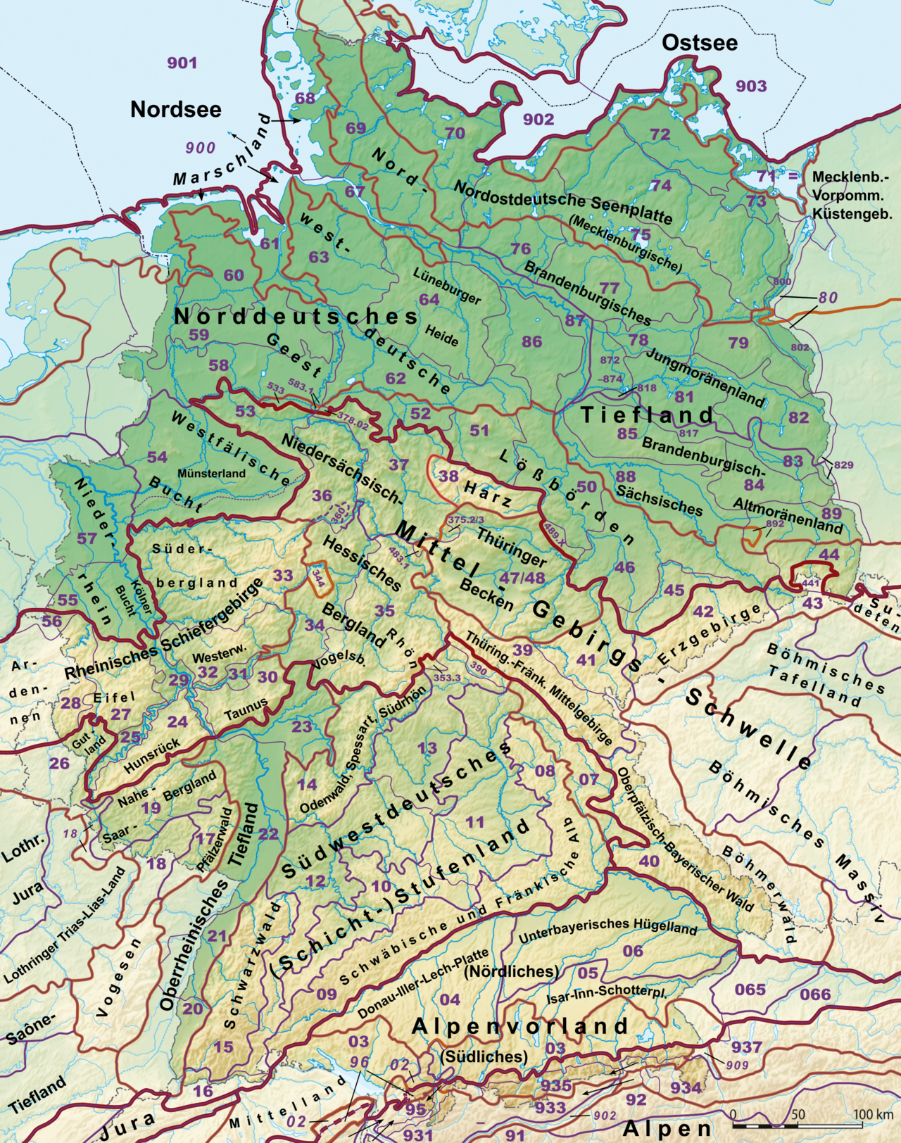
Germany's natural regions are landscape units defined by geology, relief, soils, climate and vegetation rather than political borders. They range from low, flat coastal plains to ancient uplands and the young Alpine chain in the south. These units help describe environmental variation across the country and form the basis for ecological assessment, landscape planning and conservation.
Image gallery
10 Images



Classification and main units
Several classification schemes exist, but most recognize broad belts: the North German Plain along the North and Baltic Sea coasts; the Central Uplands (Mittelgebirge) of low mountains and plateaus; the Alpine foreland and the Bavarian Alps. Within those belts are many named subregions distinguished by local relief, rock type and land cover.
Geology and formation
The shape of German landscapes reflects long geological history. Glacial action in the Pleistocene produced tills, moraines and lake districts in the north and northeast. Older, eroded mountain masses from ancient orogenies now form the Central Uplands, carved by rivers into valleys and plateaux. The Alps in the south are comparatively young fold mountains, with steep relief and high peaks.
Typical regions and examples
- North German Plain: sandy coasts, marshes, and dune systems.
- Central Uplands: ranges such as the Harz, Eifel, Hunsrück and Black Forest with forested slopes and river valleys.
- Alpine region and foreland: foothills, glacial lakes and high mountain terrain.
- Coastal and lacustrine areas: Wadden Sea mudflats, Frisian islands, Mecklenburg lake district.
Uses, ecology and cultural importance
Natural-region delineations guide habitat protection, agriculture, forestry and tourism. Soil types and microclimates determine crop patterns; upland forests support timber and biodiversity; coastal and wetland zones are crucial for migratory birds. Landscapes also shape regional identities, place names and land use traditions.
Distinctions and practical notes
Natural regions do not align with administrative boundaries and different scientific traditions use varied hierarchies and names. For applied work, planners and conservationists typically adopt a standardized national framework or regional maps to ensure consistent assessment and management.
Questions and answers
Q: What are the natural regions of Germany?
A: The natural regions of Germany are the North German Plain, the Central Uplands, the Alpine Foreland and the Alps.
Q: What is the North German Plain?
A: The North German Plain is a large flat area in northern Germany, situated between the North Sea and the Central Uplands.
Q: What are the Central Uplands?
A: The Central Uplands are a series of low mountain ranges, hills and plateaus that cover central and southern Germany.
Q: What is the Alpine Foreland?
A: The Alpine Foreland is a hilly area situated between the Central Uplands and the Alps, characterized by rolling hills and fertile valleys.
Q: What are the Alps?
A: The Alps are a major mountain range in Europe that run through several countries, including Germany, Austria, Switzerland and Italy.
Q: What is the topography of Germany like?
A: The topography of Germany is varied, with large areas of flat plains in the north and rolling hills, low mountains, high plateaus and rugged mountain ranges in the central and southern parts of the country.
Q: Which of the natural regions of Germany do the Alps belong to?
A: The Alps belong to the Alpine Foreland and are situated in the southern part of the country.
Related articles
Author
AlegsaOnline.com Natural regions of Germany Leandro Alegsa
URL: https://en.alegsaonline.com/art/68776