Namibia: Geography, History and Contemporary Overview
Concise overview of Namibia covering location, landscape, history, people, government, economy, conservation and practical distinctions for further reading.
The Republic of Namibia is a sovereign state on the southwest coast of Africa, facing the Atlantic Ocean. It is bordered by Angola and Zambia to the north, Botswana to the east and South Africa to the south. The narrow Zambezi (formerly Caprivi) area gives Namibia proximity to several neighbours; the country does not border Zimbabwe but approaches it closely. Windhoek is the capital and administrative centre. Namibia achieved internationally recognised independence in 1990 after a long period under South African administration; before that it was commonly known as South West Africa.
Image gallery
10 Images


Geography and natural environment
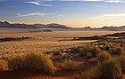
Namibia is known for striking and varied landscapes. The coastal Namib Desert, which lends the country its name, runs along much of the Atlantic shore and contains some of the highest sand dunes on Earth. North of the coastal plain are escarpments and a central plateau that descends toward savanna and woodland in the northeast. The Etosha salt pan and surrounding parks support distinctive wildlife concentrations, while the Skeleton Coast is famed for its fog, shipwrecks and stark scenery.
Major rivers such as the Kunene in the north and the Orange in the south define portions of the international frontier and support irrigation where water is available. Much of the country is arid to semi-arid; rainfall varies greatly by region and is often seasonal. Water management, the availability of groundwater and the impacts of climate variability are persistent concerns for settlement, agriculture and wildlife.
History and development
Human occupation of the territory dates back many thousands of years and includes hunter-gatherer and pastoralist cultures. Modern colonial history began in the late 19th century when the area became a German colony known as German South West Africa. After World War I it was administered by South Africa under an international mandate, and South African policies had a long influence on the territory's institutions and society.
In the mid-20th century an organized independence movement emerged, led by the South West Africa People’s Organization (SWAPO). Decades of diplomatic and armed struggle, together with international pressure, contributed to the transition to independence in 1990. Since then Namibia has worked to build democratic institutions, reconcile diverse communities and address historical inequalities.
People, language and government
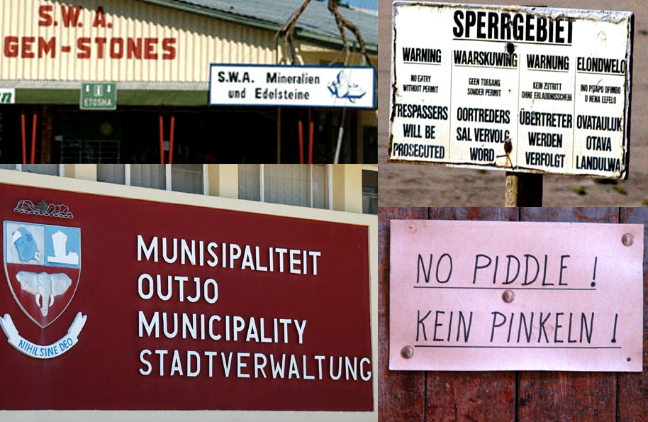
Namibia is home to multiple ethnic groups and languages. English is the official language chosen at independence to promote national unity; several indigenous languages such as Oshiwambo, Nama/Damara and others are widely spoken. German and Afrikaans continue to be used in parts of society and business, reflecting colonial-era influences.
The country is a constitutional republic with a multiparty political system, regular elections and a separation of powers. Administratively it is divided into regions that provide local governance and service delivery. The population is relatively small compared with the country's land area, with roughly two million inhabitants concentrated in towns and more fertile regions.
Economy and natural resources
Namibia's economy depends on several key sectors. Mining—especially diamonds and uranium—has been an important source of export revenue. Fishing along the productive Atlantic coast is significant for both domestic supply and exports. Agriculture is constrained by aridity; livestock rearing and small-scale cropping are common where conditions permit.
Tourism is a growing contributor to the economy, drawing visitors to wildlife areas, desert landscapes and cultural experiences. The government and private sector have sought to diversify the economy, expand infrastructure and improve services while managing natural-resource use sustainably.
Conservation, wildlife and tourism
Conservation is a major policy priority in Namibia. The country was an early adopter of community-based natural resource management, creating conservancies that allow local communities to benefit from wildlife and tourism. Etosha National Park, coastal reserves and private reserves are key sites for wildlife viewing and research. Popular destinations include the dunes around Sossusvlei, the Skeleton Coast and riverine areas in the northeast.
Society, development challenges and international relations
Namibia faces development challenges common to many countries with historical inequalities: rural poverty, the need for land reform, unemployment and the demand for wider access to education and healthcare. Infrastructure expansion, sustainable water use and inclusive economic growth are long-term priorities. On the international stage Namibia maintains diplomatic relations across the region and participates in multilateral organizations that address trade, security and environmental issues.
Notable distinctions and further reading
- Capital: Windhoek — official information
- Independence: 1990 — historic overview
- Former name: South West Africa — colonial history
- Main desert: Namib Desert — natural history
- Major parks: Etosha and coastal reserves — conservation
- Official language: English — language policy
- Other languages: German, Afrikaans, indigenous tongues — linguistic diversity
- Economy: mining, tourism, fisheries, agriculture — economic profile
- Population: about two million people — demographics
- Borders: Angola, Zambia, Botswana, South Africa — geopolitical map
- Early inhabitants: hunter-gatherers and pastoralists — anthropology
- Colonial era: German and South African periods — colonial timeline
- Wildlife initiatives: community conservancies — conservancy models
- Coastline: Atlantic and the Skeleton Coast — coastal features
- Practical travel: visas, safety and seasons — traveller guidance
This article is an introductory summary. For more detailed research consult specialized sources and the links above for topics such as history, ecology, governance and current affairs.
Etymology
The name of the state is derived from the Namib, which occupies the entire coastal area of the country. It was chosen as a neutral name at independence in order not to disadvantage any of the many Namibian peoples. Mburumba Kerina is considered the creator of the name Namibia.
On 12 June 1968, the name Namibia was recognised by the General Assembly of the United Nations.
Geography
→ Main article: Geography of Namibia
Namibia lies between 17.87° and 29.9808° south latitude and 12° and 25° east longitude.
Namibia is bordered by the Kalahari to the east of Botswana, the Orange River to the south of South Africa, the South Atlantic Ocean to the west and the Kunene and Okavango rivers to the north of Angola. In the northeast there is also a land finger about 450 km long and up to 50 km wide between the northern bordering countries Angola and Zambia and the southern bordering Botswana - the Caprivi Strip, which is bordered in the eastern area by the Zambezi and the lower reaches of the Kwando.
In addition to the border rivers mentioned above, there are numerous other rivers, none of which, however, carries water all year round with any certainty. Outside the rainy season, only dried up river beds (Riviere) can be found.
The entire national territory of Namibia covers about 824,292 square kilometres. Namibia's landscape is essentially characterised by two deserts, in the west by the Namib, which extends from the South African province of the Northern Cape far into Angola, and in the east by the Kalahari. Between the two deserts lies the inland highlands, which are on average 1700 metres high and around the capital Windhoek also exceed the 2000-metre mark. One of the most prominent mountains is the Etjo, but the highest mountain is the 2600 metre high Königstein in the Brandberg massif, near the coast, about 200 kilometres north of the coastal town of Swakopmund. To the east, the inland highlands gradually merge into the Kalahari highlands, which are around 1200 metres high and covered in dry vegetation.
Time zone
→ Main article: Legal time in Namibia
Namibia has used the same time as South Africa (UTC+2) all year round since 3 September 2017, as it did between 1990 and 1994.
Geology
The area of today's Namibia is considered one of the oldest parts of the earth's crust. Long before the formation of the supercontinent Gondwana, two shelves formed in the area of today's Africa more than two billion years ago: the Congo Craton and the Kalahari Craton. The latter covers large parts of present-day Namibia. Through various tectonic processes, a huge, coherent continental area was then formed about 550 million years ago, which included today's (partial) continents of Africa, South America, Australia, India and Antarctica: Gondwana.
About 150 million years ago, this supercontinent gradually began to break up and drift apart into the continents we know today. The special climatic conditions in Southwest Africa, which lasted for millions of years, led to the fact that many geological structures, processes and phenomena are particularly well preserved and can therefore still be observed today. Ultimately, this also includes the Namib, which can thus be considered the oldest desert in the world.
· 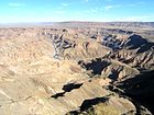
Fish River Canyon
· 
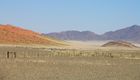
NamibRand Nature Reserve - Wolwedans
· 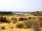
Okavango near Rundu
· 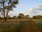
Farm road near Omaruru
· 
Namib
Climate
The average climate of Namibia is hot and dry. The largely arid climate is subtropical continental. There are large differences between the individual parts of the country:
Rainfall is extremely rare in the Namib west of the break-off stage. There is a warm, strong wind all year round. Even in winter, temperatures often reach 25°C and more. In the hottest summer months, December and January, temperatures are usually well above 30 °C, while in the coldest months, July and August, they can drop to freezing point at night, but then rise again to around 25 °C during the day. In the mornings and evenings, especially in winter, temperatures can jump by more than 20 °C within a few hours. In the inland highlands, due to the high altitude, there can even be frost at night and, in very rare years, snowfall. During the day it is not quite as hot as in the desert. The Kalahari is similar to the Namib. The precipitation is a little more frequent, but still desert-typical rare.
The area between the Namib and the Atlantic Ocean is one of the regions with the best climate for astronomical observations worldwide. The astro camps established there are therefore visited by many star lovers, especially for the purpose of sky photography.
The climate of the Atlantic coast, in turn, is determined by the cold Benguela Current. This strongly cools the prevailing southwest wind, which prevents the formation of (rain) clouds due to condensation and regularly creates a dense persistent fog near the ground. In summer it is pleasantly cool here and in the winter months it can sometimes be very cold during the day. The water temperature rarely reaches more than 15 °C.
The Caprivi Strip, on the other hand, is characterised by mostly reliable rainfall during the rainy season. These have given rise to an extensive river system and a subtropical savannah forest. The humidity is relatively high here, in contrast to the other parts of the country.
In the central highlands, which cover most of Namibia, summer rains prevail, i.e. irregular but occasionally very heavy rainfall can be expected between November and April; the extreme south, on the other hand, is in the winter rainfall area, so that - if at all - rainfall occurs mainly in the months of June and July. Despite the irregularity of the rainfall in terms of frequency and yield, it increases significantly from the south with less than 50 mm per year towards the northeast with up to 600 mm per year, which, however, does not exclude regional dry periods of several years.
Due to the special climatic conditions, agricultural use of the land is only possible to a limited extent: in the highlands mainly cattle breeding (in the north rather cattle, in the south rather sheep and goats), in the relatively rainy north also agriculture. A special feature of the Namib are the dunes in the area of Sossusvlei. With a height of more than 400 metres, the star dunes are among the highest in the world. The attraction of this dune landscape lies not only in its height, but above all in its play of colours, which depends on the moisture content and the position of the sun.
See also: Namibia/Climatic tables


Questions and answers
Q: Where is Namibia located?
A: Namibia is located in southern Africa on the Atlantic coast.
Q: Which countries border Namibia?
A: Angola and Zambia border Namibia to the north, Botswana to the east, and South Africa to the south.
Q: When did Namibia gain independence from South Africa?
A: Namibia gained independence from South Africa in 1990.
Q: What was Namibia called before it gained independence?
A: Before it gained independence, Namibia was called South West Africa.
Q: What is the capital of Namibia?
A: The capital of Namibia is Windhoek.
Q: What language is spoken in Namibia?
A: German is still widely spoken in the country, although English is the official language.
Q: Why is Namibia named after the Namib Desert?
A: Namibia is named after the Namib Desert because it is said to be the oldest desert in the world.
Related articles
Author
AlegsaOnline.com Namibia: Geography, History and Contemporary Overview Leandro Alegsa
URL: https://en.alegsaonline.com/art/68197
Sources
- cms2.my.na : cms2.my.na
- imf.org : "Report for Selected Countries and Subjects"
- data.worldbank.org : "GINI index (World Bank estimate)"
- hdr.undp.org : "Human Development Report 2019"
- worldwildlife.org : Namib desert (AT1315)
- klausdierks.com : "Biographies of Namibian Personalities, A"
- klausdierks.com : "Warmbad becomes two hundred years"
- britannica.com : "German South West Africa"
- onwar.com : "Namibian War of Independence 1966–1988"
- ipu.org : "Namibia National Council"
- windhoekcc.org.na : "City of Windhoek Cooperations and Partnerships"
- southafrica.net : "A Framework/Model to Benchmark Tourism GDP in South Africa"
- namibian.com.na : "Tourism in good shape – Minister"