Nagorno-Karabakh: geography, history, and the long-standing dispute
Overview of Nagorno-Karabakh: its geography, ethnic makeup, historical background, political status, major conflicts (1990s, 2020, 2023) and humanitarian and geopolitical implications.
Overview
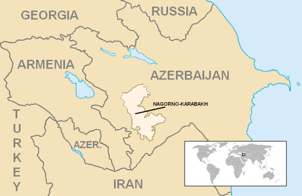
Nagorno-Karabakh is a mountainous territory in the South Caucasus with a complex political and ethnic history. It lies within the internationally recognized borders of Azerbaijan but has long had a majority ethnic Armenian population. The region's modern name combines Russian, Turkic and Persian elements and is commonly referenced in international reporting and diplomacy; see regional context.
Image gallery
10 Images


Geography and population
The area is characterized by rugged, elevated terrain and a continental climate, with its principal city locally known as Stepanakert and referred to in Azerbaijani as Khankendi. Historically the region included several districts that were organized under Soviet administration as the Nagorno-Karabakh Autonomous Oblast. The population for decades was predominantly ethnic Armenian, a central factor in competing national claims.
Historical background and major conflicts
Longstanding tensions escalated during the final years of the Soviet Union and led to open war in the late 1980s and early 1990s. A ceasefire in 1994 left most of the territory and adjacent lands under control of ethnic Armenian forces, who organized an unrecognized local government often called the Republic of Artsakh; this entity is described in many sources and is linked here as Artsakh. The dispute re‑ignited in a large-scale, short-duration war in 2020, commonly referred to as the 2020 Nagorno-Karabakh war, in which Azerbaijani forces regained substantial territory (2020 conflict).
Recent developments and status
Since 2020 there have been shifts in control, security arrangements involving third parties, and periodic clashes. Internationally the territory is still recognized as part of Azerbaijan (legal status), while the de facto authorities and local institutions were supported politically and culturally by Armenia (Armenian connections) until renewed hostilities and diplomatic pressures changed the situation again in 2023. Questions of recognition, withdrawal of forces, and the movement of civilians have featured prominently in reporting and negotiations (diplomatic and legal issues).
Political significance and humanitarian concerns
The dispute matters regionally and internationally because it affects interstate relations, minority rights, displaced populations and energy and transit routes through the South Caucasus. Humanitarian issues include displacement, property claims, and the cultural heritage of communities. International mediators and formats have sought negotiation, but a durable political settlement has been difficult to achieve.
Key points and further reading
- Territory: mountainous area within Azerbaijan's borders.
- Population: historically majority ethnic Armenian.
- Political status: internationally part of Azerbaijan; locally governed by unrecognized authorities for long periods.
- Recent conflicts: large-scale fighting in the early 1990s, 2020, and significant developments in 2023.
For regional context and ongoing developments consult sources on South Caucasus affairs and reporting by international organizations and news outlets: regional context, legal status, 2020 conflict, Armenian connections, Artsakh and diplomatic and legal issues.
Names
The name is derived from the name of the larger region Karabakh. This is composed of originally Persian and Turkish word components, so in Azerbaijani "qara" means "black" and "bağ" "garden", together they mean "black garden". Armenians primarily use the name Arzakh (Armenian Արցախ', in scientific transliteration Arc'ax, in English transcription Artsakh) for Nagorno-Karabakh, which historically refers to the Arzakh province of the ancient Armenian kingdom of the Artaxids and the medieval kingdom of Arzakh.
Geography
The region is located in the greater Karabakh region, which stretches between the Kura and Aras rivers. While neighbouring Lower Karabakh to the northeast lies in the Kura plains in the Kura-Aras lowlands, Nagorno-Karabakh comprises the adjacent foothills of the Lesser Caucasus, in particular the Karabakh Mountains and the Karabakh Highlands, as well as the Murovdağ mountain range to the north. The highest elevation, the 3724 m high Gamış dağı, is also located in the latter. In the south, the region is bordered by the Aras River, which also forms the state border with Iran. To the west is the region of Sangesur and Sjunik respectively. The region is not exactly delimited. More recently, it has often been identified with the former Nagorno-Karabakh Autonomous Oblast within the former Azerbaijan SSR, which, however, only covered part of the Karabakh Mountains. The autonomous area covered 4,400 square kilometres.
Nagorno-Karabakh slopes eastward to the Kura lowlands as well as southward to the Aras; almost all rivers flow from west to east or south. The largest rivers are the Hakari, which flows into the Aras, and the Tartar and Khatschen, which flow through Lower Karabakh into the Kura. In the course of the millennia canyons developed at these watercourses. The largest lake is the Sarsang reservoir on the Tartar. The largest city in the region with over 50,000 inhabitants is Stepanakert, which is also the capital of the Republic of Arzakh. All other towns are much smaller with a few thousand inhabitants at most. Historically significant as the former capital of the Khanate of Karabakh is Shusha (Armenian Շուշի Shushi), which, however, lost a large part of its population due to the Nagorno-Karabakh conflict.
The landscape changes from steppe in the lower valleys and plains to dense oak and beech forests to birch forests and alpine meadows at higher altitudes. The average annual temperature is 11 degrees Celsius.

Questions and answers
Q: What is Nagorno-Karabakh?
A: Nagorno-Karabakh is a disputed region in the South Caucasus.
Q: Is Nagorno-Karabakh legally recognized as part of Azerbaijan?
A: Yes, Nagorno-Karabakh is recognized as part of Azerbaijan.
Q: Who controlled most of Nagorno-Karabakh from 1994 until the 2020 Nagorno-Karabakh war?
A: From 1994 until the 2020 Nagorno-Karabakh war, most of Nagorno-Karabakh was militarily controlled by Armenians as the Republic of Artsakh.
Q: Is the Republic of Artsakh recognized by any other country?
A: No, the Republic of Artsakh is not officially recognized by any other country.
Q: Does Armenia support the Republic of Artsakh?
A: Yes, Armenia supports the Republic of Artsakh.
Q: Who currently controls Nagorno-Karabakh?
A: Currently, different parts of Nagorno-Karabakh are controlled by both Azerbaijan and Armenia.
Q: Which country controls most of Nagorno-Karabakh currently?
A: Azerbaijan controls most of Nagorno-Karabakh currently.
Related articles
Author
AlegsaOnline.com Nagorno-Karabakh: geography, history, and the long-standing dispute Leandro Alegsa
URL: https://en.alegsaonline.com/art/68109
Sources
- un.org : un.org/press/en/2008/ga10693.doc.htm