Münster — historic city in North Rhine-Westphalia
Münster is a historic German city known for its medieval architecture, university, bicycle culture and role in the Peace of Westphalia. It is the cultural and administrative centre of the Münsterland region.
Overview
Münster (German: Münster; sometimes written Muenster where ü is unavailable — see spelling note) is a city in the northwest of the German state of North Rhine-Westphalia. Historically the chief town of Westphalia, it grew around a medieval monastery (Latin: Monasterium) and today combines a significant student population with administrative and cultural roles. The city is commonly known for its compact old town, prominent university and extensive bicycle infrastructure.
Image gallery
10 Images


Names and language
The place name appears in several regional forms: in the local Münster dialect as Mönster, in Dutch as Munster, and in Frisian as Múnster. Older Germanic sources recorded variants such as Mimigernaford. The modern German spelling uses the umlaut ü; in international contexts the alternative spelling Muenster is widely used.
History and identity
Münster has medieval origins and rose to prominence in the Middle Ages as a religious and commercial centre; it retained importance through the Renaissance. It is well known as one of the cities where the treaties of the Peace of Westphalia were negotiated and signed in 1648, a diplomatic settlement that reshaped European politics. The city also experienced dramatic events such as the 16th‑century Anabaptist uprising that briefly established a radical communal regime.
Institutions, culture and landmarks
Münster is home to the University of Münster (WWU Münster), one of Germany's largest universities, and a variety of museums, theaters and galleries. Key landmarks include St. Paulus Cathedral and the Prinzipalmarkt with its historic arcades. Cultural life blends traditional festivals with contemporary arts and an active student scene that shapes the city's calendar.
Transport, economy and daily life
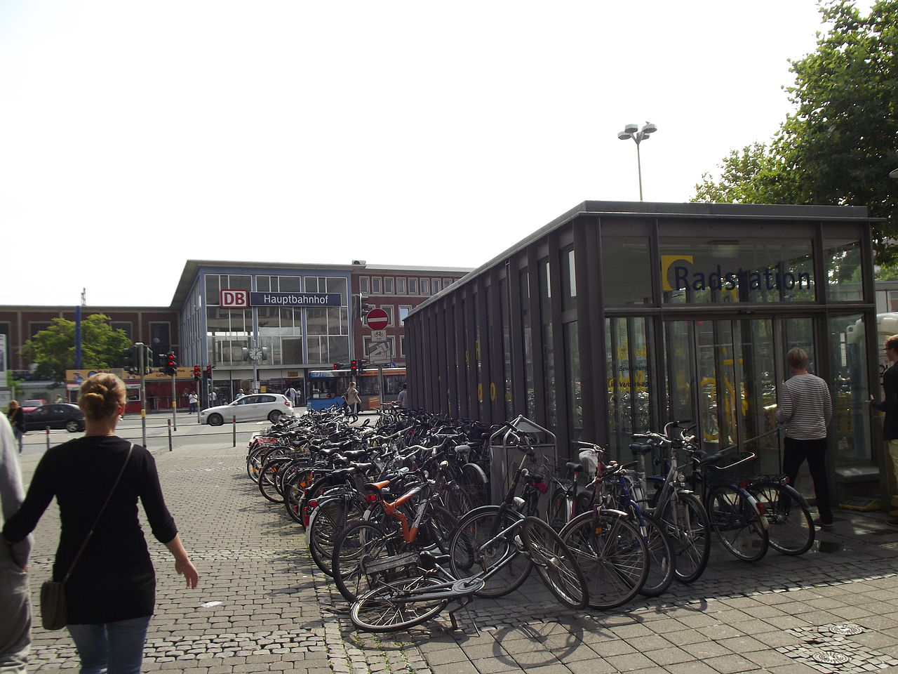
The city's economy rests on education, public administration, small and medium industry, and services. Münster is noted for high bicycle usage and bike‑friendly planning; on many days bicycles outnumber cars in the central district. The nearest commercial airport serving the region is Münster/Osnabrück Airport, and rail and road links connect the city with regional and national networks.
Practical information and further reading
Population figures vary with time; the city is home to roughly three hundred thousand residents, including a large student cohort. For historical background see resources on the Middle Ages and the Renaissance, or consult official state and city pages for current data and services (state information). Additional municipal and visitor information is available through local portals and university publications.
- Notable facts: site of the Peace of Westphalia, major university, exemplary cycling city.
- Good to know: alternative spellings and regional names reflect Münster's long linguistic and cultural history.


Geography
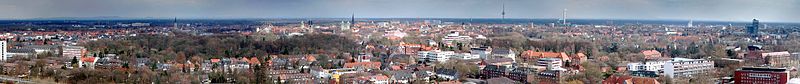
Panorama - on the left the green of the castle garden, in the middle the towers of the inner city churches St. Lamberti and St. Paul's Cathedral, on the right the LVM building
Geographical position
Münster lies on the Münstersche Aa, 15 km south of its confluence with the Ems, in the Westphalian lowland bay covered by sandy-loamy deposits in the middle of a landscape characterised by scattered settlements and individual farms, the Münsterland. The Saale ice-age sediments of the Münsterland gravel-sand train run through the middle of the town in a north-south direction. The highest point is the Vorberg hill in the Vorbergs Hügel nature reserve at 99.8 m above sea level, the lowest point is in the north of the city area on the Ems at a height of 38.6 m above sea level. Münster's city centre is at 60 m above sea level, measured at Prinzipalmarkt in front of the town hall.
The Dutch city of Enschede is about 65 km away. Other large cities in the vicinity are the major cities in the Ruhr area (Herne and Bochum each about 55 km and 59 km southwest, Dortmund about 61 km south, and Gelsenkirchen 61 km southwest), Osnabrück about 44 km north, Hamm about 34 km south and Bielefeld about 62 km east.
Münster is one of the 42 German densely populated areas and is one of the largest cities in Germany. However, this includes larger sparsely populated, rural areas of the towns incorporated in 1975. Almost half of the urban area is used for agriculture, which explains the relatively low population density of a good 1000 inhabitants per km².
In addition, the contiguously built-up urban area is comparatively large in terms of surface area, as the development is lower than in other cities with a comparable number of inhabitants. This is mainly due to the high proportion of single-family houses and villas, as well as the fact that most of the apartment buildings are only two to three storeys high. High-rise buildings, on the other hand, are few and far between, and there are no tenement blocks or skyscrapers in Münster. Compared to other German cities, it is noticeable that the houses are often built in brick and often have gables instead of eaves. Nevertheless, in the city centre around the historic core there are high population densities of up to 15,000 inhabitants per km² in some areas. This results in a settlement density, i.e. the population density in the populated urban area, of around 2,890 inhabitants per km².
The total area of the city of 300.327 km² is divided into 74.181 km² settlement areas, 26.429 km² traffic areas, 194.012 km² vegetation areas and 6.001 km² water areas. The circumference is 107 km, the extension from north to south 24.4 km and from west to east 20.6 km.
Climate
The city's precipitation amounts to about 773 mm per year (average 1981-2010), which is about average for Germany. Nevertheless, Münster is a rainy city - not because of the absolute sum of precipitation, but rather because of relatively many rainy days (on average 189 per year) with often little precipitation. The Münsterland dialect even has a special term for the unproductive but prolonged precipitation: the word "Meimeln". The average temperature is 9.8 °C with about 1580 hours of sunshine per year. In terms of annual sunshine hours, however, Münster fares worse than many southern and eastern German cities. Münster's winters are relatively mild compared to the rest of Germany, so that it snows comparatively rarely, while the summer temperatures correspond to the national average.
The highest daily rainfall was recorded on 28 July 2014: The MeteoGroup weather station at Aasee/Zoo reported a rainfall of 122.2 l/m², while the State Environment Agency recorded 292.5 l/m² within seven hours at its station at the main sewage treatment plant. The record rainfall led to heavy flooding throughout the city and in neighbouring Greven.
| Munster | ||||||||||||||||||||||||||||||||||||||||||||||||
| Climate diagram | ||||||||||||||||||||||||||||||||||||||||||||||||
| ||||||||||||||||||||||||||||||||||||||||||||||||
| Monthly average temperatures and precipitation for Münster
Source: DWD, data: 2015-2020 | ||||||||||||||||||||||||||||||||||||||||||||||||||||||||||||||||||||||||||||||||||||||||||||||||||||||||||||||||||||||||||||||||||||||||||||||||||||||||||||||||||||||||||||||||||||||||||||||||||||||||||||||||||||||||||||||||||||||||||||||||||||||||||||
Neighbouring municipalities and districts
The town borders the following towns and municipalities - they are named clockwise, starting in the northwest: Altenberge and Greven (Steinfurt district), Telgte, Everswinkel, Sendenhorst and Drensteinfurt (Warendorf district), as well as Ascheberg, Senden and Havixbeck (Coesfeld district).
City breakdown
According to § 1 of the city's main statutes, Münster's urban area is divided into the six city districts of Mitte, Nord, Ost, West, Süd-Ost and Hiltrup. In each district there is a district council with 19 members, who are elected by the population of the district at each local election. The chairman of the district council is the district mayor. According to the main statute, the individual boroughs are further divided into residential areas. However, this official term is practically not used. Instead, the term district is used as a synonym for residential area. For statistical purposes, these residential areas are further subdivided into a total of 45 statistical districts.
The following is a list of the city districts with their associated residential areas and further residential places in accordance with the main statutes of the city of Münster. These are the official designations as listed in the statutes, which partly differ from the designation in common usage:
- Middle:
- Core area
- North:
- Coerde
- Children's House
- Sprakel with Sandrup
- East:
- Gelmer with the district of Gittrup and the districts of Mariendorf and Sudmühle
- Handorf with Kasewinkel, Kreuzbach, Laer, Dorbaum and Verth left of the Ems and Werse rivers
- Mauritz-Ost and Mondstraße, collectively known as St. Mauritz
- West:
- Albachten
- Gievenbeck
- Mecklenbeck
- Nienberge with Häger, Schonebeck and Uhlenbrock
- Roxel with Altenroxel and Oberort
- Sentrup Heights
- Southeast:
- Angelmodde with Hofkamp
- Gremmendorf with Loddenheide
- Wolbeck
- Hiltrup:
- Amelsbüren with Sudhoff, Loevelingloh and Wilbrenning
- Mount Fidel
- Hiltrup
The core area of the city can be divided into historically developed districts. The boundaries of these districts are often not precisely defined. The districts include Aaseestadt, Erphoviertel, Geistviertel, Hansaviertel, Herz-Jesu-Viertel, Kreuzviertel, Kuhviertel, Mauritzviertel, Pluggendorf, Rumphorst, Südviertel, Uppenberg and Zentrum Nord. The districts of the five outer boroughs largely comprise the areas of the formerly independent municipalities before they were incorporated into Münster over time.
Demographics
→ Main article: Population development of Münster
In 2014, the population of Münster exceeded the 300,000 mark for the first time. On 31 December 2017, 313,559 people had their main residence in Münster. Of these, 281,226 are of German nationality (approximately 89.7 percent), while the foreign share is approximately 10.3 percent or 32,333 people. By comparison, in 2000 the city still had 265,609 inhabitants, in 2010 the figure was just under 280,000. According to Information und Technik Nordrhein-Westfalen, the population forecast for 2040 is just under 350,000 inhabitants. When breaking down the present population (as of 2019) by age group, the 20- to 29-year-olds make up the largest class (20.1 percent), followed by the 30- to 39-year-olds (14.5 percent), the 50- to 59-year-olds (13.7 percent) and the 40- to 49-year-olds (11.9). The group of 10 to 19 year-olds accounts for 8.9 percent and the group of 60 to 69 year-olds for 9.7 percent. Life expectancy in Münster is 79.5 years for men and 84.3 years for women. This is one of the highest life expectancies of all German cities.


History
City history
→ Main article: History of the city of Münster
It is estimated that the small Saxon settlement of Mimigernaford was located in the area of the cathedral square from the 6th century onwards. In 793, the Frisian missionary Liudger founded a monastery (Latin: monasterium) at the ford over the Münstersche Aa, which gave its name to the town that developed here. In 805 he was appointed the first bishop of Münster and construction work began on the first cathedral.
Due to the growing number of inhabitants, Münster was granted town charter in 1170. The construction of the city fortifications falls into this period. The city wall was about four kilometres long and was reinforced by further fortifications in the middle of the 14th century. At this time Münster was the largest city in Westphalia. In the city's local government in the late Middle Ages, the Leischaften played an important role by appointing the electors, who were involved in the election of the councillors. Until 1458, the passive right to elect councillors was reserved exclusively for the city nobility, popularly known as hereditary men. Only hereditary families such as the Bischopinck, Droste zu Hülshoff, Kerckerinck (all others are now extinct) etc. provided the councillors, mayors and prince-bishop's town judges. The Erbmänner, after whom many streets in Münster are named, represented Münster in the prince-bishop's government, in the Diet of the High Chapter and at the Hanseatic Days.
Between 1358 and 1454 Münster gained great importance as a member and from 1494 as a suburb of the Hanseatic League in Westphalia. The Prinzipalmarkt, for example, bears witness to this, with its magnificent merchants' houses dating from this era, many of which were destroyed in the Second World War and many of which were rebuilt in simplified form.
In 1534 the dramatic episode of the Anabaptist kingdom of Münster began. It culminated in the proclamation of the Kingdom of Zion in September 1534 by Jan van Leiden with himself as king. This kingdom, however, lasted only until June 24, 1535, when troops of Bishop Francis of Waldeck captured the besieged city. The tortured and executed Anabaptist leaders were subsequently hung in three iron baskets at the Lamberti Church as a deterrent. The originals of the baskets, dating from 1535, still hang there. Mistakenly, they are often referred to as cages. The reasons for this are mainly reports from foreign authors and visitors who, from the end of the 18th century onwards, reported on the rule of the "Anabaptists" with negatively connoted terms, as well as translation errors of Latin manuscripts about the Anabaptist kingdom.
In 1648, an event of European significance took place in Münster and Osnabrück. The Peace of Westphalia was concluded, ending the Thirty Years' War and the Eighty Years' War. As a "Site of the Peace of Westphalia", the Town Hall in Münster, along with that in Osnabrück, was awarded the European Heritage Label by the European Commission in mid-2015.
At the same time, around the year 1648, the struggle for the city's independence reached its climax. It culminated in the attempt to elevate Münster to the status of a Free Imperial City. This, however, predetermined the conflict of the bourgeoisie with the ecclesiastical sovereign. It resulted in an open confrontation with Prince-Bishop Christoph Bernhard von Galen, who took the city in 1661 after an eight-month siege and temporarily deprived it of all rights.
After the death of the last prince bishop in 1801, the city was occupied a year later by the Prussian general Gebhard Leberecht von Blücher. This measure was not legitimized until 1803 by the Reichsdeputationshauptschluss, before Napoleon's troops captured and occupied the city in 1806. As a result of the agreements reached in 1807 in the Peace of Tilsit, the city and the surrounding area became part of the Grand Duchy of Berg in 1808. Münster became the capital of the department of the Ems. Finally, in 1811, the region was ceded to France. Münster now belonged to the Hanseatic Departments and became part of the French Empire. In 1813 the French were driven out of the city by Prussian and Russian troops. Since the reorganization of Europe by the Congress of Vienna, Münster officially belonged to the Kingdom of Prussia from 1815 and was the provincial capital of the newly founded province of Westphalia.
Due to the economic upswing in the second half of the 19th century and the incorporation of smaller surrounding communities, the number of inhabitants exceeded 100,000 in 1915 and Münster became a large city. At the end of the First World War - as in the capital Berlin - the republic was proclaimed on 9 November 1918 on Neuplatz. The Soldiers' Council, which was set up a short time later, was not deprived of its power until a few months later in February 1919 by General Oskar von Watter.
During the National Socialist era, Münster was the seat of the Gauleitung of the Gau "Westfalen-Nord" (Westphalia-North) as well as of the Ordnungspolizei (order police), under whose leadership approximately 200,000 "order forces" were involved in the mass murder of Jews, Sinti, Roma, homosexuals and other groups. An outstanding personality of the resistance against the National Socialists was Clemens August Graf von Galen, who became known far beyond the borders of the city and diocese of Münster through his fight against the arbitrariness of the Gestapo against Catholic institutions and the inhuman euthanasia programme of the National Socialists, and was given the nickname The Lion of Münster. During the Second World War, Münster was one of the most heavily destroyed cities in Germany. About 91% of the old town and 63% of the entire city were destroyed by British bombing as part of the Morale Bombing Strategy. In early April 1945, Münster was occupied by US troops. Elsewhere in Germany, the war continued until early May. It ultimately ended on 8 May with the unconditional surrender of the Wehrmacht.
In the 1950s, unlike in many other large German cities, a part of the historic old town was rebuilt similar to its pre-war state at the insistence of the population.
The 24th German Fire Brigade Day was held in Münster from 17 to 21 June 1970.
On 18 June 1990, Hans-Dietrich Genscher and Eduard Shevardnadze met in Münster in the historic town hall to prepare the Two Plus Four talks that paved the way for reunification. The people of Münster gave the politicians an enthusiastic reception on the Prinzipalmarkt, which visibly moved Shevardnadze.
At the end of July 2014, Münster and the surrounding area experienced some of the most severe thunderstorms in recent years. Especially on 28 and 29 July, several strong thunderstorms passed over the same area one after the other. The amount of rain that fell in Münster represented an event of the century. A station of the State Environment Agency reported a volume of 292 l/m² within seven hours; otherwise, an average of around 69 l/m² falls in the whole of July. Countless streets and cellars were flooded, one person died in his flooded cellar. The city of Münster expects damage of 15 to 20 million euros to municipal buildings and infrastructure alone. On 7 April 2018, there was a rampage in the city centre; four people were killed; the rampage driver took his own life.
Incorporations
In 1816, Münster, which covers 1.89 km², was the most densely populated city in Westphalia, with 7983 people per km². On its way from a medieval city to a modern metropolis, the city experienced several incorporations:
| Date | Incorporated areas | Area (km²) |
| January 1, 1875 | Parts of the municipalities Lamberti, Sankt Mauritz and Überwasser | 8,9 |
| corresponds approximately to the area of the inner city ring plus Kreuzviertel, Mauritzviertel, Hansaviertel, Südviertel as well as the northern tip of Geistviertel | ||
| April 1, 1903 | Lamberti: Gremmendorf with Loddenheide, Berg Fidel, Aaseestadt, Geistviertel and Mecklenbeck | 56,4 |
| Overwater: Kinderhaus, Gievenbeck and Sentrup | ||
| Part of Sankt Mauritz: Rumphorst as well as parts of today's St. Mauritz | ||
| 1 October 1956 | Parts of Coerheide, Kemper and Gelmer, combined to the district Coerde | 6,6 |
| 1 January 1975 | the Amt Sankt Mauritz with the municipalities of St. Mauritz, Handorf, Hiltrup, Amelsbüren and Sprakel | |
| of the Amt Roxel the municipalities Albachten, Nienberge and Roxel (the remaining parts of the Amt, Bösensell and Havixbeck, fell to the Kreis Coesfeld) | 228,4 | |
| the municipalities of Angelmodde and Wolbeck (the remaining parts of the district, Albersloh, Alverskirchen and Rinkerode, were assigned to the district of Warendorf) |


Related articles
Author
AlegsaOnline.com Münster — historic city in North Rhine-Westphalia Leandro Alegsa
URL: https://en.alegsaonline.com/art/67579
Sources
- destatis.de : "Alle politisch selbständigen Gemeinden mit ausgewählten Merkmalen am 31.12.2018 (4. Quartal)" · web.archive.org
- destatis.de : destatis.de/DE/ZahlenFakten/LaenderRegionen/Regionales/Gemeindeverzeichnis/Administrativ/…
- it.nrw.de : "Amtliche Bevölkerungszahlen"
- commons.wikimedia.org : Münster