Mount Vesuvius: geology, history, hazards and cultural legacy
An overview of Mount Vesuvius — its geology, famous eruptions (including AD 79), archaeological legacy, risk to surrounding communities, and scientific monitoring.
Mount Vesuvius (Italian Monte Vesuvio) is a prominent stratovolcano rising above the Gulf of Naples in Italy. Located about nine kilometres east of the city of Naples, it is one of the best known volcanoes in Europe because of its long history of explosive eruptions and its proximity to dense settlements. Vesuvius belongs to the arc of Italian volcanism and is often contrasted with other active Italian peaks such as Etna and Stromboli, which lie on nearby islands and have different eruptive styles.
Image gallery
10 Images


Geology and behaviour
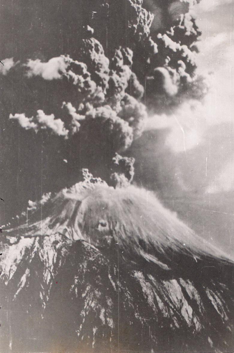
Vesuvius is a composite cone built by alternating layers of lava, ash and pumice typical of stratovolcanoes. Its eruptions are often explosive, producing tephra, ash and fast-moving pyroclastic flows rather than steady, runny lava. The volcano sits above a complex plumbing system that feeds volatile-rich magma; eruptions can range from sustained Plinian columns that spread tephra widely to dense, ground-hugging surges that sweep slopes. Repeated cycles of collapse and growth have altered the summit morphology, leaving a pronounced crater and a surrounding landscape of volcanic deposits.
Historic eruptions and archaeological impact
Vesuvius is most famous for the eruption of AD 79, which overwhelmed nearby Roman towns and buried them under meters of ash and pumice. The cities of Pompeii and Herculaneum were preserved in remarkable detail, enabling modern archaeologists to reconstruct everyday life in the ancient world. That eruption also altered local waterways and shorelines — contemporary accounts and later studies note changes to the former beach and course of the Sarno river (the sea beach was raised and sediments redirected).
Later activity and human consequences
Vesuvius has erupted many times since AD 79. Significant eruptions in later centuries periodically affected agriculture, towns and regional trade. The volcano’s last major eruption that involved sustained activity occurred in 1944, during which lava and explosive activity damaged nearby settlements. Because of the volcano’s explosive character and the dense population of the surrounding plain, Vesuvius is considered one of the most dangerous volcanoes in the world: estimates commonly cite approximately three million people living in the wider metropolitan area and its environs.
Culture, mythology and excavation
The mountain has long been embedded in local myth and artistic expression. Literary and ritual evidence link the peak to Roman religion and legend: classical authors and inscriptions reflect worship and mythic associations, including references preserved by historians such as Diodorus Siculus. Material culture from the buried towns — from domestic frescos to inscriptions invoking deities like Jupiter — show how Vesuvius figured in civic and household cults. Ancient stories sometimes situate heroes such as Hercules near the region on journeys toward places like Sicily, and literary authors even allude to gods of love such as Venus in connection with the devastated sites. Excavations that began in earnest in the 18th century revealed the buried urban fabric and sparked modern disciplines of archaeology and conservation.
Risk management, science and modern uses
Because of its threat to a large population, Vesuvius is a focus of continuous scientific monitoring and civil-protection planning. Italy’s observatories and emergency agencies combine seismic, geodetic and gas measurements to detect signs of unrest, and public authorities maintain evacuation plans for the most exposed districts. The volcanic soils on the slopes remain agriculturally valuable, supporting vineyards, orchards and horti that have used Vesuvius’s fertility for centuries, while the archaeological parks and panoramic viewpoints attract large numbers of visitors. The site therefore combines natural hazard, cultural heritage and economic importance in a concentrated landscape.
Further reading and resources
- Monte Vesuvio: local names and identity
- Stratovolcano characteristics
- Geography of the Gulf of Naples
- Italy: national context
- Naples and urban proximity
- Volcano hazards overview
- Etna: comparison
- Stromboli: comparison
- Italy’s island volcanism
- The AD 79 eruption
- Roman-era contexts
- Pompeii: archaeological site
- Herculaneum: archaeological site
- Coastline and river changes
- Literary responses to Vesuvius
- Frescos and domestic religion
- Cult of Jupiter Vesuvius
- Diodorus Siculus and ancient reports
- Hercules in local myth
- Sicily and regional routes
- Venus and classical allusions
Geological development
Mount Vesuvius lies above a volcanically active subduction zone between the African and Eurasian continental plates. It is part of the Romana volcanic belt, which extends from Monte Amiata near Siena to Monte Vulture near Potenza.
The volcano, which borders the Gulf of Naples to the south and west, has a circumference of about 80 km at its base and covers an area of about 480 km². Also called the Somma-Vesuvius complex, the stratovolcano consists of two concentric cones, the outer of which is barely extant. The top of the original Somma collapsed in 79 AD to form a caldera about 4 km in diameter, which is almost completely filled with the products of subsequent eruptions. Only the northeastern part of the crater rim is still visible as a crescent-shaped wall. It overhangs the floor of the collapse basin by 200 m and reaches a height of 1132 m at Punta Nasone. This rampart remnant of the older cone bears the name Monte Somma. In the caldera the actual Vesuvius cone (also called Gran Cono) was formed as a daughter volcano. Today it is 1281 m high. Monte Somma and Vesuvius are separated by the 5 km long Valle del Gigante. The western part of this valley is called Atrio del Cavallo, the eastern part Valle dell'Inferno. The peculiarity of this volcanic formation coined the term Somma volcano for a volcano with summit caldera surrounding a younger filler cone.
The base of Somma-Vesuvius is about 1000 m below the present sea level. The cone lies on a sedimentary sequence of the Mesozoic and Tertiary several kilometres thick. Tertiary sandstones, marls and clays, limestone xenoliths of the Cretaceous and Jurassic, and dolomites of the Triassic are found in the volcanic products. The thickness of the Mesozoic strata is given as 1500 to 1700 m each. Between the sediments and the volcanic base there is a layer of grey Campanian tuffs, which originates from the neighbouring volcanic area of the Phlegraean Fields and is about 39,000 years old.
Seismic measurements indicate that the roof of the magma chamber lies at a depth of about 5.5 km in the Triassic dolomites. The geologist Alfred Rittmann came to the same conclusion after examining contact metamorphic ejecta, since only the dolomites are particularly strongly altered from the volcanic products. They must therefore have been in prolonged contact with the magma. According to Rittmann's calculations, the chamber volume is 50 km³, the chamber radius is given as approx. 3 km.
· 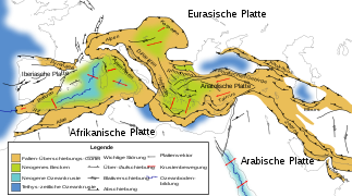
General tectonic situation of the central region
· 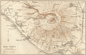
Historical map of Vesuvius from Meyers Konversationslexikon (1888)
· 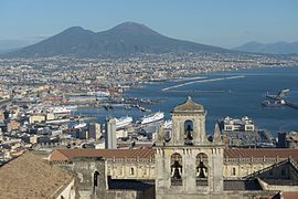
Naples and Mount Vesuvius (2016)
· 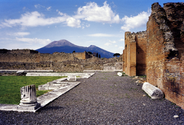
Vesuvius in 1998, seen from Pompeii
· 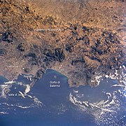
Location of Mount Vesuvius on the Gulf of Naples - NASA-Johnson Space Center (2004)


Explanation and exploration of the volcano
Interpretations
In ancient times, the volcanically active area on the Gulf of Naples was considered a landscape with connections to the underworld. The Phlegraean Fields near Vesuvius were regarded as the dwellings of the giants and the fire god Vulcanus, and Lake Averne, also nearby, is said to have been the entrance to the realm of the dead for Aeneas. But while in antiquity critical voices such as Seneca still sought rational explanations for earthquakes and volcanism, in the Middle Ages the volcano was associated with the afterlife even for scholars. In the 11th century, Peter Damiani told of demons stoking the fires of Vesuvius for the damned. Subsequently, the mountain, with its bursts of fire and sulfuric exhalations, became visible evidence of the existence of purgatory, if not the entrance to hell itself. Supernatural powers were also invoked for protection, most notably the poet Virgil, revered in medieval Naples as a powerful sorcerer. Since the eruption of December 16, 1631, Saint San Gennaro assumed the role of patron saint. A procession on 17 December 1631, in which the relics of the saint were held up to Vesuvius as a weapon, is said to have been attended by 100,000 people. After surviving eruptions in the 18th century, the people of Naples erected votive monuments to him.
In the 17th century, however, scientific exploration of the volcano began. The Jesuit Athanasius Kircher climbed the mountain in 1638, and in 1665 he summarized his observations and investigations in the work "Mundus subterraneus" to form a theory according to which the volcanic regions of the earth were connected by an underground system of fire channels. This began a series of researches, at the end of which Vesuvius is considered to be the best-studied volcano on earth; Kircher's thesis, however, did not prevail. The researchers of the early modern period were still convinced, as the ancient scholars had once been, that the earth was criss-crossed by caves filled with air and water. Their movements and storms were considered to be the cause of earthquakes and volcanism. Explosive chemical processes were also discussed. Even Johann Heinrich Zedler's Universal-Lexicon, which appeared from 1732 to 1754, blamed the activity of "fire-spewing mountains" on "sulphurous and nitrous vapour" igniting in the earth's interior, in addition to subterranean winds.
Giovanni Maria Della Torre and Giuseppe Maria Mecatti also held to the view that mineral fermentation processes triggered volcanic eruptions. Both ecclesiastical scholars published in the 18th century after investigations and experiments at the Vesuvius much-noticed research reports, which count particularly in method questions to the bases of the volcanology. A different attitude only began to prevail with the work of William Hamilton. The British diplomat was envoy at the court of Naples from 1764 to 1799. During this time he explored the Italian volcanoes, his Villa Angelica near Torre Annunziata, a place at the foot of Vesuvius, serving as a base for his regular scientific excursions to the mountain. He also had Padre Piaggio, a learned monk, keep a diary that meticulously recorded the mountain's activities over a 14-year period. Hamilton's work was significant not only for the development of a recent theory of the formation of the earth. He was also one of the first to devote himself to a task that is still one of the main objectives of volcano research today: the prediction of eruptions and disaster control. For Hamilton, as for the other early researchers, Vesuvius, along with Etna, was at the centre of the scientific study of volcanic phenomena; it was not until the beginning of the 19th century, with the publications of Alexander von Humboldt, that the perspective broadened and Vesuvius became one volcano among many. Humboldt observed an eruptive eruption in 1822, describing the collapse of the ejecta cone and the variability of the crater rims, and he theorized that volcanoes were connected to the Earth's interior by a vent. Compared with the South American volcanoes he had explored in the years before, however, Vesuvius was for him only "a picturesque hill".
Nevertheless, it has not lost its importance for science: from the Vesuvius Observatory, built in 1841 on the south side of the mountain as the first volcanological observation station ever, its activity is intensively monitored and recorded without gaps to this day. The observatory maintains a network of geodetic, geochemical and seismic measuring stations, whose data are available to science and civil protection.
Seismic measurements in the 1990s resulted in a three-dimensional model of Vesuvius and the volcanic areas of Campania, which extends up to 300 km below the earth's surface. The series of measurements led, among other things, to the discovery of a shallow magma field that lies 11-15 km below the Earth's surface and extends beneath the entire volcanic area of Campania. While the magma chamber located at 5-6 km depth is responsible for the plinian eruptions, the deeper reservoir triggers the "interplinian" activity. This field has been identified as the source of the 1631-1944 eruptions. It is fed by a third magmatic layer located at a depth of about 20 km. The seismic data are also processed into hazard scenarios; these models show the probability of being hit by a pyroclastic flow or volcanic ejecta in the vicinity of Vesuvius. While pyroclastic flows propagate relatively uniformly, the hazard from tephra precipitation is much higher in the east, as westerly winds prevail in the Vesuvius area.
Classical outline
The "classical" classification was developed by Alfred Rittmann, who had studied the volcano since the 1930s and laid the foundation for all subsequent work. He distinguished four evolutionary phases: The Ur-Somma, the Alt-Somma, the Jung-Somma and the Vesuvius.
According to this, the Ur-Somma was formed by an initial eruption 12,000 years ago, during which the magma penetrated to the surface from a focal depth of about 6 km. After that, a volcanic pause of at least 2000 years set in. The roof of the partially emptied magma chamber subsided, leading to local marine transgression. At the same time, the magma chamber shifted upwards by about 500 m into the Triassic dolomites. The magma crystallized out, releasing gases that slowly rose to the top (H2O, HCl, H2S, and others). These and the gases from the assimilated sediments caused the hearth internal pressure to continue to rise. As a result, a new eruption occurred 8000 years ago, and during the subsequent 2500-year active phase, the Alt-Somma, a 1000-m-high stratovolcano, was formed. The vent then collapsed. The volcano was inactive for several centuries, and erosion and soil formation set in. However, the assimilation of the Triassic dolomites in the chamber continued, there was a renewed gas accumulation and a new eruption, which ejected the gas-rich upper part of the magma chamber in the form of pumice stones (it.: Pomici). Thus, about 5000 years ago, the activity of the Young Somma began. During this period, two more major eruptions occurred, and at their end the volcano reached a height of over 2000 meters. After a dormant period lasting several centuries, a final eruption of Jung-Somma finally occurred in 79 AD, destroying Pompeii, Herculaneum, and other smaller towns. In the summit caldera of Young Somma, the cone of today's Vesuvius was formed from the 3rd century AD onwards.
The classical picture has not completely lost its validity. However, recent research has significantly advanced the formation of the Somma volcano and has specified the number of major eruptions and their dating.


Questions and answers
Q: What is Mount Vesuvius?
A: Mount Vesuvius is a stratovolcano on the Gulf of Naples, Italy. It is about 9 kilometres (5.6 mi) east of Naples and is the only volcano on the mainland of Europe that has erupted in the last 100 years.
Q: When was its last major eruption?
A: The last major eruption of Mount Vesuvius was in 1944.
Q: What other active volcanoes are located in Italy?
A: Two other important active volcanoes in Italy are Etna and Stromboli, which are both located on islands.
Q: How did the eruption of 79 AD affect Pompeii and Herculaneum?
A: The eruption destroyed the Roman cities of Pompeii and Herculaneum, burying them in ash so completely that later people who lived there forgot about them until they were accidentally discovered in the late 18th century. The eruption also changed the way the Sarno River flowed, and raised the sea beach, meaning that Pompeii was no longer next to either river or coast anymore.
Q: How did this event change Mount Vesuvius itself?
A: Many plants around Mount Vesuvius died as a result of this event, while its topography was altered due to its strong eruption.
Q: Why is it considered one of most dangerous volcanoes today?
A: Today, Mount Vesuvius is considered one of most dangerous volcanoes because approximately 3 million people live near it - more than any other volcano in the world - making it an explosive hazard for those living nearby.
Q: What historical significance does Mount Vesuvius have? A:Mount Vesuvius has a long tradition of history and literature associated with it; for example, a serpent (snake) called "Vesuvius" has been used in frescos from Pompeii's lararia (household temples), while words such as "IOVI VESVVIO" (Jupiter Vesuvius) suggest he was worshipped as a power associated with Jupiter by Capua's inhabitants . Additionally, according to Diodorus Siculus' writings , Hercules once passed through Cumae where he found a place called "the Phlegraean Plain", which had previously vomited out fire and became known as 'Vesuvius'.
Related articles
Author
AlegsaOnline.com Mount Vesuvius: geology, history, hazards and cultural legacy Leandro Alegsa
URL: https://en.alegsaonline.com/art/67116
Sources
- doi.org : 10.1016/j.jvolgeores.2007.08.020
- earth-prints.org : "Influences of urban fabric on pyroclastic density currents at Pompeii (Italy): Part II: temperature of the deposits and hazard implications"