Mount Tambora: Indonesian stratovolcano and the great 1815 eruption
Mount Tambora is an active Indonesian stratovolcano known for its massive 1815 eruption, which formed a large caldera and caused worldwide climatic effects and regional devastation.
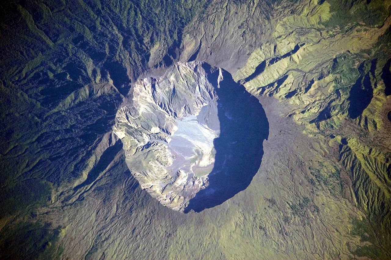
Mount Tambora is a prominent stratovolcano on the northern rim of Sumbawa Island in Indonesia. It sits within a subduction zone where the Indo-Australian Plate dives beneath the Eurasian Plate; this tectonic setting drives frequent volcanism in the region. The volcano is notable for a cataclysmic eruption in 1815 that removed the summit and created a large caldera, reshaping the local landscape and producing measurable effects around the globe. For general location and maps see location references.
Image gallery
10 Images


Physical description and geology
Tambora was a tall, conical stratovolcano before 1815; the eruption destroyed a large portion of its summit and left a caldera. Its eruptions are typical of subduction-related volcanoes: explosive, and capable of producing high columns of ash, pyroclastic flows and widespread tephra deposits. The volcano is often described and studied in the context of its tectonic setting—an active subduction zone—see geological context at subduction zone resources.
The 1815 eruption and immediate effects
The April 1815 eruption is one of the largest in recorded history. It produced enormous clouds of ash and gases that blanketed surrounding islands and generated fast-moving pyroclastic flows. The summit collapse formed a broad caldera and removed much of the mountain's pre‑eruption height. Eyewitness and later scientific study characterized the event as highly explosive, with devastating local consequences and significant loss of life. Contemporary and modern accounts of the eruption can be found at primary eruption sources.
Global climatic impacts and aftermath
Volcanic aerosols from the eruption entered the stratosphere and altered global atmospheric conditions for months to years afterward. The result was unusually cold and wet weather in parts of the Northern Hemisphere the following year, contributing to crop failures, food shortages and economic disruption in various regions. Locally, tens of thousands of people died from the eruption itself, collapsing communities, and subsequent famine and disease.
Later activity, research and visiting
- Subsequent eruptions at Tambora have been smaller but the volcano remains classified as active and is monitored by volcanologists.
- The caldera and deposits from 1815 are important for volcanic research, paleoclimate studies and hazard assessment.
- Trekking to the crater rim is a popular but demanding activity; guides and local authorities offer information for visitors and researchers.
Tambora's 1815 eruption is significant both as a natural disaster with major human costs and as a climatic forcing event that links a single volcanic eruption to global environmental effects. It remains an object of geological, historical and environmental study and a reminder of the far-reaching influence of large explosive volcanism.

Geographical location
Tambora is located on Sumbawa, one of the Lesser Sunda Islands. It forms a segment of the Sunda Arc, a chain of volcanic islands that make up the southern part of the Indonesian archipelago. Tambora is located on a peninsula of Sumbawa called the Sanggar Peninsula. To the north of this peninsula is the Floressee, and to the south is Saleh Bay, 86 km long and 36 km wide. In the mouth of the bay is the small island of Mojo.
Archaeology
In addition to seismologists and volcanologists who monitor the mountain's activity, biologists and archaeologists also conduct scientific studies in the Tambora area. In 2004, a team of volcanologists led by Haraldur Sigurdsson discovered a village buried under pyroclastic deposits near the crater (caldera) by the 1815 eruption. Bones and artifacts were recovered at the excavation site. At this site - also referred to as the "Pompeii of the East" in the press at the time because of the similar demise of the village - archaeologists hoped to have found the palace of the Rajah of the Tambora "kingdom" destroyed by the eruption. So far, there have been no other finds under the thick layers of material ejected from the crater.
Tourism
Today, the area also serves as a tourist destination. The two nearest towns are Dompu and Bima. Around the mountain slope are three villages, Sanggar in the east, Doro Peti and Pesanggrahan in the northwest, and the small town of Calabai on the west coast.
The caldera is accessible via two different routes. The first starts in the village of Doro Mboha to the south-east of the mountain and leads along a paved road to an altitude of 1150 m above sea level through kashu plantations. The end of this route is the southern part of the caldera at 1950 m above sea level, which can be reached by a hiking trail. This place is usually used as a base camp for volcano watching, as the caldera can be reached from there in about an hour. The second route starts from the village of Pancasila on the northwest side of the mountain. A driveway continues for about 7 km through coffee plantations to Lerang Tambora, a settlement of coffee planters, from where a sometimes arduous trail continues initially through dense tropical rainforest.


Geological history
Formation
Tambora lies 340 kilometres north of the Sunda Trench and 180 to 190 kilometres above the upper margin of the north-dipping Benioff Zone. Sumbawa is fringed by oceanic crust to the north and south. The rate of convergence of the Indo-Australian, Eurasian and Pacific plates meeting here is about 7.8 centimetres per year. The age of Tambora is estimated to be at least 57,000 years.
Tambora measures about 60 kilometers at sea level. The current altitude is 2850 m compared to an estimated 4300 m before the eruption in 1815.
According to a geological survey, before the eruption Tambora had a high volcanic cone with a central shaft from which lava frequently escaped and flowed down the flanks of the mountain. Today, the stratovolcano consists of the volcanic deposits within the caldera, which reach up to its rim with heights of up to 2700 m in the northwest and up to 2750 m in the west and southwest.
The older stratovolcano consists of interlocking layers of lava and pyroclastics, the successor is formed to about 40% of one to four meters thick, often interrupted lava flows.
There are at least 20 subsidiary cones, some of which have been named: "Tahe" (877 meters), "Molo" (602 meters), "Kadiendinae", "Kuba" (1648 m) and "Doro Api Toi". Most of these secondary cones produced basalt lava flows.
Eruption history
Radiocarbon dating has shown that there were three eruptions of Tambora before 1815, but their magnitude is unknown. The dates are estimated to be 3710 BC (± 200 years), 3050 BC and 740 AD (± 150 years). All eruptions had comparable characteristics: an explosive eruption of the volcano from the central eruption channel, with the last one having no pyroclastic flows.
In 1812, Tambora became highly active, reaching its eruptive maximum in April 1815. The eruption was equivalent to a magnitude seven on the VEI scale, with a total of 60 to 160 cubic kilometers of ejected pyroclastic precipitation. Features of the eruption included explosive eruptions from the central channel, pyroclastic flows, tsunamis, and a caldera collapse. The eruption had long-term effects on global climate. Follow-up activity from the volcano was recorded in August 1819 in the form of a small eruption of magnitude two on the VEI scale. Between 1850 and 1910, eruptions occurred again, but were confined to the caldera. Small lava flows and domes were created. The strength was two on the VEI scale. During these eruptions, the "Doro Api Toi" - a secondary cone within the caldera - was created.
The last eruption of Tambora was recorded in 1967, and it was a very small, non-explosive eruption.
Questions and answers
Q: What is Mount Tambora?
A: Mount Tambora is an active volcano located in Indonesia.
Q: Where is Mount Tambora located?
A: Mount Tambora is located at 8°14’41”S, 117°59’35”E in Indonesia.
Q: Why was Mount Tambora taller before its explosive volcanic eruption in 1815?
A: Mount Tambora was taller before its explosive volcanic eruption in 1815 because the eruption caused a collapse of its summit.
Q: How many people died because of Tambora's explosive volcanic eruption in 1815?
A: Tens of thousands of people around the world died because of Tambora's explosive volcanic eruption in 1815.
Q: Have there been any smaller eruptions of Mount Tambora after the 1815 eruption?
A: Yes, there have been smaller eruptions of Mount Tambora after the 1815 eruption.
Q: What type of plate boundary is Mount Tambora on?
A: Mount Tambora is on top of a subduction zone.
Q: Is Mount Tambora still active?
A: Yes, Mount Tambora is still an active volcano.
Related articles
Author
AlegsaOnline.com Mount Tambora: Indonesian stratovolcano and the great 1815 eruption Leandro Alegsa
URL: https://en.alegsaonline.com/art/67101
Sources
- volcano.si.edu : "Tambora"
- peakbagger.com : "Gunung Tambora"
- doi.org : 10.1126/science.224.4654.1191
- pubmed.ncbi.nlm.nih.gov : 17819476
- peaklist.org : "Mountains of the Indonesian archipelago"
- doi.org : 10.1191/0309133303pp379ra
- doi.org : 10.1007/s004450050222