Mount Ararat: geography, geology, cultural importance, and climbing
Mount Ararat is a snow-capped dormant volcano in eastern Turkey, the highest peak of the Armenian Highlands and an important cultural symbol in the region.
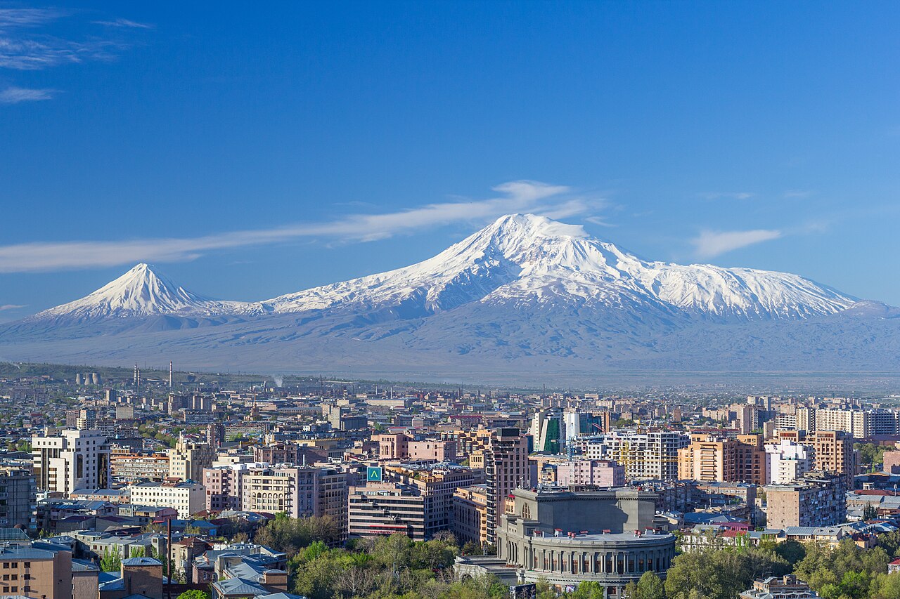
Mount Ararat is a dominant volcanic massif in the highlands of eastern Anatolia. The mountain is known by several local names, for example the Turkish name Ağrı Dağı and Armenian forms represented by Ararat. It stands within modern Turkey's Iğdır Province near the borders with neighboring states: roughly 16 km west of Iran and about 32 km south of the Armenian frontier. The summit remains snow-covered for much of the year and dominates the surrounding steppe.
Image gallery
10 Images


Geography and main features
Ararat consists of two principal cones: the higher Greater Ararat and the smaller Lesser Ararat. Greater Ararat reaches a high point often given as about 5,165 metres above sea level and is the highest point in both the Armenian Highlands and in the Republic of Turkey. Lesser Ararat lies to the west and is a distinct lower peak. The range forms a striking landmark visible for many tens of kilometres across the plain.
Geology
Geologically, Ararat is a compound stratovolcano formed by successive layers of lava and pyroclastic deposits. It is typically described as dormant rather than extinct: there is no frequent recent activity, but the mountain has experienced eruptions in earlier geological and historical periods. The upper slopes were glaciated in the recent past; glaciers and permanent snowcaps have retreated and fluctuated with climate variations.
Cultural and historical significance
Ararat occupies a prominent place in the traditions and identity of peoples across the region. It is closely associated with the biblical tradition that locates Noah's Ark on 'Ararat'—a term that in ancient sources can refer to a wider mountainous region rather than a single peak. For Armenian culture in particular, the mountain is a powerful national symbol, appearing in art and emblems. At the same time, Ararat sits inside the borders of modern Turkey, making it a subject of cross-border interest and historical memory.
Climbing, access and conservation
Mount Ararat attracts climbers and pilgrims. The first recorded modern ascent of the higher peak was by an early 19th-century expedition led by explorers such as Friedrich Parrot assisted by local climbers and guides. Today climbs require legal permission and coordination with Turkish authorities; routes demand high-altitude experience, appropriate acclimatisation and glacial travel skills when snow and ice are present. The mountain's lower slopes support steppe and montane vegetation, and the area is subject to conservation concerns related to tourism and environmental change.
Notable facts
- The mountain is frequently described as perpetually snow-capped; observers often note the white summit contrasting with the plains below — a visual quality referenced in literature and travel accounts (snow-cap).
- As a volcanic edifice it is classified among Turkey's dormant volcanoes (volcanic).
- Local languages record a variety of names and associations, including Kurdish forms and regional toponyms (Kurdish).
- Maps and encyclopedic descriptions commonly treat Ararat both as a physical landmark and as a cultural symbol; for overviews consult general references and regional studies (more on the mountain).
For practical details on visiting, routes, permits and local guides, travellers should consult current sources and contact authorities or experienced operators before attempting an ascent (local information, regional guides, border considerations, heritage contexts). Additional reading and images are available through specialised alpine and historical resources (volcanology, glaciology, ethnography).
Geology and eruption history
The last eruption of the volcano took place in 1840. It destroyed the village of Ahora on the northeast side.
Coat of Arms Controversy
Even though Ararat is located in Turkey today, it is the national symbol of the Armenians, most of whom had their settlement area around Ararat in the six Armenian Eastern Provinces in the Ottoman Empire until the Armenian Genocide in 1915. It was on the national coat of arms of the Armenian SSR and is also on the coat of arms of Armenia. Turkey protested, saying that the mountain was on Turkish territory and therefore should not be appropriated by Armenia or the Soviet Union. Soviet Foreign Minister Gromyko later countered by pointing out that, in contrast, Turkey flies the moon as a crescent in its flag, although neither the moon nor any part of it belongs to Turkey.
Related articles
Author
AlegsaOnline.com Mount Ararat: geography, geology, cultural importance, and climbing Leandro Alegsa
URL: https://en.alegsaonline.com/art/66995
Sources
- volcano.si.edu : Global Volcanism Program