Mexico City
![]()
Mexico City is a redirect to this article. For the film of the same name, see Mexico City (film).
19.4194444444-99.14555555562310Coordinates: 19° 25′ N, 99° 9′ W
Mexico City (Spanish Ciudad de México [sjuˈða(ð) ðe ˈmexiko], until 2016 México D.F. ) is the capital of Mexico. It does not belong to any constituent state, but forms its own territorial entity, home to 8.9 million people (2015). The metropolitan region Zona Metropolitana del Valle de México (ZMVM), which includes Mexico City, the eastern part of the state of México and a municipality from the state of Hidalgo, is one of the largest on earth with over 21 million inhabitants.
The city is the political, economic, social and cultural center as well as the largest transportation hub in the country. It is the seat of the Archdiocese of Mexico as well as numerous universities and technical schools. UNESCO declared its historic center with the remains of the Aztec capital Tenochtitlan as well as the water gardens in the Xochimilco district a World Heritage Site in 1987 and the central university campus of the Universidad Nacional Autónoma de México in 2007.
The name of the city
Mexicans usually call their capital el D.F. ("el De-Efe", abbreviation of Distrito Federal, "Federal District"). So when México is mentioned, the state is usually meant. Less frequently, and usually in an official context, it refers to La Ciudad de México. The country of Mexico, in turn, takes its name from its current capital. Inhabitants of the city are referred to as capitalinos ("capitals"), defeños (derived from D.F. ) or chilangos, and the word mexicano again refers primarily to the republic. The name México originally goes back to the Aztecs, who called themselves "Mexica". In German-speaking countries, the English-language term Mexico City is also sometimes used for "Mexico City".
On 29 January 2016, the Spanish name of the city was also officially changed to Ciudad de México (= Mexico City), abbreviated "CDMX".
History
Aztec Rule
According to Aztec records, the founding of the city under the name Tenochtitlan dates back to 1345, when a band of nomads from the north settled on an island in Lake Texcoco. The Aztecs (actually Méxica) settled there after long years of wandering, during which they had subsisted on what had been available, voluntarily or involuntarily, in permanent settlements.
According to their tradition, they had received an order from their god Huitzilopochtli to found a city on the spot where they found an eagle sitting on a cactus and eating a snake. They found it - on an island in the middle of the lake. Eagle, snake and cactus form the central motif of today's Mexican flag.
The actual settlement history, however, was probably different. For the Méxica, who drifted from place to place, the small islands in the middle of the shallow lake meant first and foremost a good strategic point of retreat. The location was well chosen, for the lake provided them with fish, and the soil of the chinampas, the floating gardens they had created, was exceedingly fertile.
The little land available would not have been enough to feed the large city, so large rafts were built and loaded with soil. Flowers and vegetables were grown on these farmlands situated in the lake. Dams were built between the islands and the mainland to regulate the water level of the lake and were built so that the islands, connected by bridges and canals, could be flooded in an emergency. Drawbridges protected against attack (and prevented escape).
The city on the island soon covered more than 13 square kilometers. The Aztecs set about expanding their sphere of influence. First they subdued the high valley by force of arms, intrigue and with the help of changing allies. A hundred years before the Conquista, the Aztecs already commanded a vast empire in which there was a lively exchange of goods and to which even some of the most remote areas of the country were tributary.
The Conquista
→ Main article: Spanishconquest of Mexico
In 1519, Hernán Cortés landed on the east coast with a small Spanish army consisting of only a few hundred men and set out on his long march to Tenochtitlán. Several circumstances stood him in good stead: the possession of firearms, the support of tribes at war with or oppressed by the Aztecs, and the reluctance of their ruler, Moctezuma II, to offer open resistance.
The Aztec ruler, who had suffered heavy defeats fighting the Purépecha in the west, was a brooding, deeply religious man who believed he recognized in Cortés the white-headed, bearded god Quetzalcoatl, who had returned to fulfill an ancient prophecy. So on November 8, 1519, he allowed the Spaniards to enter the city; fearfully, to be sure, but with grand ceremonies of welcome. Cortés and his companions were overwhelmed by the sight of the Aztec capital. The city of 300,000 on the lake, with its magnificent buildings, could easily rival any major European city of the time. Dams regulated the waterways between the beautiful stone houses laid out in a strict pattern.
After one of Moctezuma's commanders took control of several Spaniards and sent their severed heads all over the place, Cortés captured Moctezuma in his own palace on November 17, 1519, and had him held in the Spanish camp. But if Spanish accounts are to be believed, he was ultimately stoned to death by his own people when he tried to prevent an uprising over the uninvited guests. As a result, the Spanish were driven out of the city with great loss. Cortés and some of his men escaped and found shelter with their closest allies among the natives at Tlaxcala. There they built new ships and were able to regroup their forces. With the support of their Indian partners, they held Tenochtitlán under siege for three months, finally breaking the Aztecs' desperate, suicidal resistance and taking the city on August 13, 1521.
The memory of this defeat still hurts Mexican historical consciousness to this day. There is also little sympathy for Cortés, but the indigenous people who supported him at the time, especially Moctezuma and Malinche, Cortés' interpreter, are regarded as non-persons. Not a monument to Moctezuma is to be found in the whole country, whereas the memory of his successor Cuauhtémoc, the leader of the resistance, is held in high honor. How bitter the struggle for Tenochtitlán must have been is shown by the fact that scarcely anything remains of the flourishing Aztec metropolis: "All that I saw at that time," wrote Bernal Díaz del Castillo, "has been trodden down and destroyed; not one stone has been left upon another."
Spanish and postcolonial period
The victorious Spaniards systematically destroyed every visible reminder of the ancient culture and built their churches where the great temples had stood. A palace for Cortés was built on the foundations of the ruler's palace, and the stones of the Aztec city were used for the new building. When the city had grown further, they drained most of Lago de Texcoco. From there the Spaniards undertook expeditions and subdued the Native Americans as far north as what is now the United States and as far south as Central America.
Mexico City became the capital of the Viceroyalty of New Spain in 1535, which included all the Spanish provinces in the Americas north of Costa Rica, the Caribbean islands and also the Philippines. Spanish colonial rule lasted for about three centuries. In 1551, the country's first university (UNAM) opened in the capital.
In 1692, there was an uprising of the Indians in Mexico City, during which many buildings were destroyed or damaged, including the official residence of the Spanish viceroys, which had been built on the Aztec palace in 1523. The riots were triggered by food supply shortages due to poor harvests caused by prolonged rainfall and flooding in the region.
In 1737, the "Virgin of Guadalupe" was declared the patron saint of Mexico City by the Catholic Church. In the 18th century, many churches and buildings were built in the Baroque style, which later developed into the Mexican Churriguera style.
In 1810, under the leadership of Miguel Hidalgo and José María Morelos, there was a war of independence, which ended victoriously in 1821 with the capture of the city by rebels led by Agustín de Iturbide. On July 21, 1822, he was proclaimed emperor. On September 14, 1847, Mexico City was captured by U.S. forces under General Winfield Scott after the Battle of Chapultepec in the Mexican-American War and occupied for five months.
From 1863 to 1867, after the French intervention in Mexico, the city was ruled by Emperor Maximilian and the French army. It was conquered after fierce fighting that lasted for days under the leadership of the Swiss Captain Stöckli, who served in the Foreign Legion. Benito Juárez, elected president in 1858, drove the French out of Mexico City and the entire country in 1866. After defeating the French, he personally supervised the summary execution of Emperor Maximilian I in Querétaro in 1867 and took over the affairs of state in Mexico City.
Around 1875, the city comprised little more than the area around the Zócalo, which is the central plaza in front of the cathedral, and the Alameda. Chapultepec Castle, Coyoacán, San Ángel and the Basílica de Guadelupe - by now located far inland from the city - were then surrounded by fields and the last remaining lakes. But the city was already showing the first traits of its present form: the Paseo de las Reformas already connected Chapultepec to downtown, and the growing population was spilling out beyond the colonial core. From late 1870 to 1911, dictator Porfirio Díaz had himself memorialized by means of an unprecedented construction program. Tram lines were built and the last remains of the Lago de Texcoco on the outskirts of the city were drained. These measures brought about a further increase in the population, and by the outbreak of the revolution in 1910 La Ciudad de México had more than 700,000 inhabitants.
The modern city
The city gradually expanded beyond the area of the drained lake. For a modern city, the situation was unfavorable in many respects. Pathogens spread in the inadequately drained swamps. Many buildings sank over the decades because of the lowered water table. In the centre one comes across old churches and residential buildings, some of which have sunk several metres (cf. above under hydrology). There are also frequent earthquakes, most recently on 18 April 2014 and 19 September 2017.
During the revolution, nearly two million Mexicans lost their lives and a much larger number lost their property and livelihood. Thousands of desperate people fled to the rapidly growing capital in search of work and better living conditions. Between 1920 and 1940, the city's population doubled to 1.8 million, there were huge holes in the infrastructure and social problems worsened.
At the Plaza de las Tres Culturas on October 2, 1968, the state showed its cruelest side. Troops and tanks took action against almost 250,000 demonstrating students. It was the culmination of months of student protests against the poor social conditions, miserable teaching conditions and democratic deficits of the de facto dictatorial government of the Unity Party PRI (Partido Revolucionario Institucional). As the Summer Olympics were due to open in Mexico City ten days later, the riot was suppressed with brutal violence. According to official statements, the number of fatalities amounted to 30, according to the students to over 500. The event went down in history as the "Massacre of Tlatelolco".
By 1968, the city had reached a population of six million. The construction of houses could not keep up with the annual population growth of seven percent. Moreover, since many people could not afford houses, huge slums sprang up with shanties they had built themselves. Most of them had neither water nor adequate sanitary facilities.
Also, the public transport network could not keep up with the growth of the city, although the construction of a subway was started in the late 1960s. In 2000, the 175th subway station was inaugurated. More subway stations are planned. The growth continues: According to estimates, a thousand newcomers arrive every day in the metropolis, whose borders have now burst those of the official urban area and extend far into the state of México. As one of the most densely populated metropolitan regions in the world, it is plagued by numerous social and structural problems.
Population development
Mexico City is the second largest city in Latin America after São Paulo, with 8.9 million inhabitants (2015), and one of the ten largest metropolitan areas in the world, with 21.6 million people (2019) in the agglomeration. In 2015, the population density in the city was 5,967 inhabitants per square kilometre, and 2,683 in the metropolitan area.
Mexico City has been the seat of the Spanish viceroys since the city was founded in 1521, and this gave it its position as a primacy city: it is still both the capital and the hub for the country's most important political and economic events. However, it was not until better care for the people (in health care, for example) and the establishment of numerous industrial companies from the 1930s onwards that the influx of people from the surrounding areas into the city began. In 1950, the city still had 3.1 million inhabitants. By 1970, there were already 6.9 million people and the growth rate of the metropolitan area was about one million people per year.
Population development of the city
The following overview shows the population figures according to the respective territorial status. Up to 1889, these are mostly estimates, from 1895 to 2010 they are census results. The population figures refer to the city proper without the suburban belt.
|
|
|
Population development of the metropolitan region
The metropolitan area of Mexico City has experienced an enormous expansion in population in recent decades. In recent years, however, there has been a slowdown here as well. A population of 25.4 million is expected for the year 2035.
| Year | Population |
| 1950 | 3.365.000 |
| 1960 | 5.479.000 |
| 1970 | 8.831.000 |
| 1980 | 13.028.000 |
| 1990 | 15.642.000 |
| 2000 | 18.457.000 |
| 2010 | 20.137.000 |
| 2018 | 21.581.000 |
Development of the housing situation
In 1824 Mexico City was divided into the actual city and the surrounding district, called "Zona Metropolitana de la Ciudad de México" (ZMCM). At that time, this district had a size of 1,479 square kilometres, but the city has long since outgrown its boundaries. Mexico City itself includes the areas densely populated in the urban core, growing at a rate of 1.8 percent per year. The ZMCM includes the outlying areas, mainly in the state of México, to which large numbers of people are migrating from the urban core. Annual growth in these urban districts is less than four percent per year.
The distribution of the population in Mexico City into wealthy and socially deprived districts is very striking: the people of the upper class settled in the west and south of the city at an early stage. The south, first the Colonia Roma and later Coyoacán and San Ángel were popular with the Mexican nobility. Today, the south is a popular residential area. The west became the preferred residential area for the wealthy by Emperor Maximilian, who built a palace in the 400-hectare park of Chapultepec in 1864. Many hotels, banks and insurance companies have settled in the area around Chapultepec Park. The north counts as a large industrial area: numerous industrial plants and several working-class neighborhoods can be found here. To the northwest, the bourgeois residential quarter Ciudad Satélite was built after the Second World War. It is politically part of the city of Naucalpán, a direct neighbor of Mexico City with 844,000 inhabitants (2015 census). In the east live mainly people from the middle class.
The eastern suburbs are the residential area of the socially weak population up to the Pepenadores, who search the garbage for usable remains. The lower class lives on the bottom of the Lake Texcoco, which has dried up and from which a lot of dust is often carried into the poor residential areas by the unfavourable wind. In terms of urban development, these are informal settlements, although many of the older settlements are currently in a process of gradual consolidation despite the lack of essential infrastructure (piped water, for example). The people living there are at risk from various infectious diseases spread by inadequate sanitary conditions. The city of Nezahualcóyotl is located in this area and is home to 1.1 million people (2010 census). The politically independent municipality is one of the poorest large cities in Mexico.
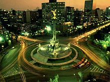
Column with the "Angel of Independence
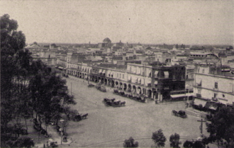
The city center around the time of the outbreak of the Mexican Revolution (around 1911)
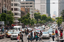
Street scene in the city centre
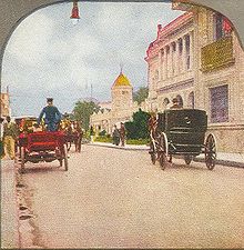
San Francisco Street 1905
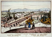
Mexico City seen from San Cosme (1847)
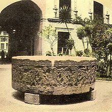
Stone of the Aztec ruler Tizoc
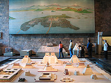
Model and picture of Tenochtitlán at the time of the Spanish conquest in the Anthropological Museum
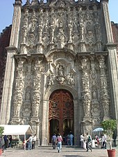
Sacrament house next to the cathedral in Mexico City
Search within the encyclopedia