Mexican–American War (1846–1848)
Armed conflict between the United States and Mexico (1846–1848) that led to the U.S. acquisition of large western territories under the Treaty of Guadalupe Hidalgo.
The Mexican–American War was a two-year armed conflict fought from 1846 to 1848 between the United States and Mexico. It grew out of competing territorial claims after the U.S. annexation of Texas in 1845, disputes about the Texas–Mexico border, and broader American expansionist sentiment often labeled "Manifest Destiny." The war ended with a negotiated settlement that reshaped the map of North America.
Image gallery
10 Images


Causes and immediate context
Key causes included disagreement over whether Texas ended at the Nueces River or the Rio Grande, the U.S. decision to annex Texas, and political pressure in the United States for westward expansion. Diplomatic breakdowns and skirmishes along the disputed frontier escalated tensions into open warfare in 1846.
Major campaigns and leaders
- Northern and interior New Mexico campaigns led by U.S. forces that secured New Mexico and California.
- Coastal and Pacific operations, including actions connected to the Bear Flag Revolt in California.
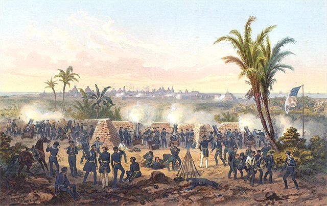
- Large pitched battles in northeastern Mexico and a U.S. amphibious and inland campaign culminating in the capture of Mexico City.
- Prominent commanders included U.S. generals Zachary Taylor, Winfield Scott, Stephen Kearny and John C. Frémont; Mexico was led by figures such as Antonio López de Santa Anna.
Outcome and legacy
The war concluded with the Treaty of Guadalupe Hidalgo in 1848. Mexico recognized the Rio Grande as the Texas border and ceded vast territories to the United States (commonly called the Mexican Cession). Under the treaty the U.S. agreed to pay $15 million and to assume certain claims by its citizens. The conflict had lasting effects on U.S.-Mexico relations, accelerated American settlement of the West, intensified domestic debates over slavery, and left enduring political and social consequences in the region.
Previous story
Situation in the USA
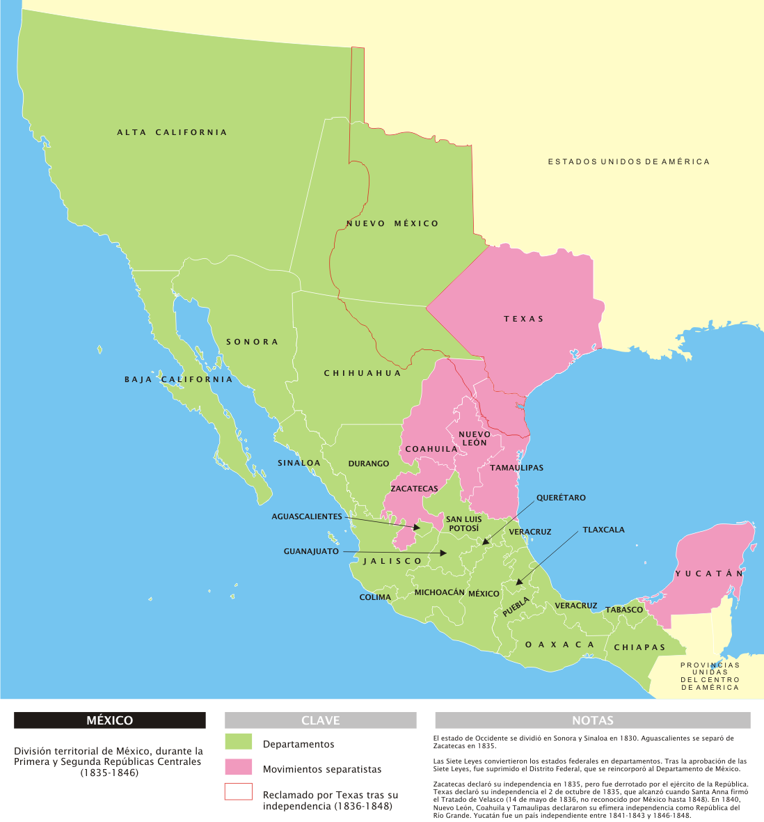
The US government had already been trying to acquire Upper California since the time of Agustín de Iturbide's government. A request that was rejected several times by Mexico and severely strained relations between the two states. Under Presidents John Quincy Adams and Andrew Jackson, the United States twice unsuccessfully made offers to purchase Texas from the Mexicans. In 1836, when the more than 35,000 U.S. citizens living in Texas declared their independence from Mexico and proclaimed the Republic of Texas, the Mexican government suppressed the U.S.-backed uprising in their country. The use of the army failed and Texas won its independence. However, the southern and western Texas border with Mexico was subsequently disputed.
On October 19, 1842, Commodore Thomas ap Catesby Jones - believing that war had broken out with Mexico - occupied Monterey, California, but withdrew on October 20 following news reports to the contrary. This and a similar incident a short time later in San Diego led to a sharp note of protest from Mexican Foreign Minister José María Bocanegra, who assumed a breach of international law and a hostile act on the part of the United States.
In the presidential campaign of 1844, James K. Polk ran as the candidate of the Democratic Party and was elected president with the program of a large-scale expansionist policy under the aspect of Manifest Destiny. Immediately after the election, he pursued the annexation of Texas to the USA.
With the annexation of the Republic of Texas on February 19, 1845, the claim that the Rio Grande constituted both the southern and western boundaries passed to the United States via what was now the State of Texas. This claim, however, was by no means secure. Under Mexican administration the boundary between the provinces of Texas and Coahuila had been the Nueces River. In the Mexican view, the Nueces River continued to form the boundary despite Texas' independence. The claim of the Rio Grande as the border was also controversial in the United States. Even Secretary of State James Buchanan found the claim dubious.
Situation in Mexico
On the Mexican side, General Antonio López de Santa Anna had been deposed as president in 1844 and sent into exile. As his successor, General José Joaquín de Herrera took over the affairs of state. After the annexation of Texas in February 1845, public opinion on both sides of the Mexican political spectrum was incensed. Herrera found that the military and financial situation was hopeless and that no help could be expected from Europe. These reasons led him to seek an agreement with the United States. In the patriotically heated mood, however, this was seen as treason and cowardice.
General Mariano Paredes overthrew Herrera and assumed the presidency in January 1846. Paredes harbored plans to amend the 1843 constitution and institute the monarchy. A king at the helm might have offered protection by the European monarchies against the expansionist desires of the United States. The plan was scuttled, however, by the early outbreak of war.
For Mexico, the territorial claims of the United States were unacceptable. With the Rio Grande as the new border, long-standing Mexican settlements in and around Santa Fe would have come under United States control. In addition, the largest city in the area, Matamoros, would have become a border city.

Start of War
Despite native and Mexican resistance, President Polk insisted on these demands and ordered General Zachary Taylor to move his army near the Rio Grande. Taylor moved into camp just south of the Nueces River, far north of the Rio Grande. The transfer of U.S. troops to territory claimed by Mexico south of the Nueces River was a provocation; however, the Mexican government took no countermeasures other than sending soldiers to the Rio Grande on the condition that they remain south of the river. Polk repeatedly urged Taylor to move closer to the Rio Grande, most recently on January 13, 1846, but Taylor delayed the departure and did not reach the Rio Grande until March 28. General Pedro de Ampudia demanded that Taylor withdraw to the Nueces River. Taylor refused and began to build a fort opposite Matamoros and seal off the Rio Grande.
When Mexico did not respond immediately, Polk decided to ask Congress for a declaration of war against Mexico. Before this happened, news reached Polk that Mexican troops had crossed the Rio Grande on April 25, 1846, and had ambushed and defeated two dragoon companies of 500 cavalrymen under Captain Seth B. Thornton. In this engagement the U.S. lost 63 soldiers. Polk now appeared before Congress and argued that a declaration of war was not necessary - that it was sufficient to state that a state of war existed as a result of Mexico's action. There is no question, however, that President Polk had opened the phase of military conflict by giving the marching orders to General Taylor and had been determined to declare war anyway. The representation of Mexico as the aggressor in this case served only to justify publicly further acts of war.
To prevent congressional opposition to his policy, Polk linked the decision to declare a state of war to a bill appropriating funds for Taylor's army. Those who opposed the war thus had to vote against supporting their own troops. Polk also made sure that deliberations on the bill had to be completed in two hours. Much of this time was spent reading a message from the President, and only at the very end was the declaration of a state of war brought in. Debate had thus been prevented. The United States Whig Party politicians opposed the war (while advocating a peaceful policy of expansion), but would not vote against supporting the troops. Only 14 out of 190 congressmen failed to vote in favor. A joint vote to fund Taylor's army and declare a state of war still had 67 congressmen voting against it. The Senate, which also had a short time frame set for debate, voted 40 to 2 in favor of passage, and so President Polk signed the bill into law on May 13, 1846. Most influential church leaders also spoke in favor of the war, or at least did not oppose it. One noted exception was the Baptist reverend and president of Brown University, Francis Wayland.
Mexico, because of the tense situation between the United States and Great Britain over the Oregon question, could hope for war between the two powers. The California junta of Monterey, which wanted to keep Alta California out of the war by seceding from Mexico, also hoped for British protection. However, after the negotiation of the Oregon Compromise, ratified in June 1846, the border disputes were settled peacefully. Peace with the British in the north left President Polk free to wage a war of conquest in the south and west against the Mexican provinces of Alta California and Nuevo Mexico.


Related articles
Author
AlegsaOnline.com Mexican–American War (1846–1848) Leandro Alegsa
URL: https://en.alegsaonline.com/art/64314
Sources
- pbs.org : "US–Mexican War, 1846–1848"
- pbs.org : "The Borderlands"
- history.com : "Mexican-American War"
- umich.edu : "Timeline of Major Events"
- mtholyoke.edu : "Mexican-American War, An Investigation Utilizing the Just-War Theory"