Massif Central — highlands of south-central France
Ancient upland region in south-central France noted for Variscan geology, extensive plateaux, numerous extinct volcanoes (Auvergne), and its influence on rivers, ecology, agriculture and regional identity.
The Massif Central is a large upland region in south-central France that occupies roughly fifteen percent of the country. It is a complex mosaic of mountains, plateaux and river valleys rather than a single continuous range: its relief includes folded massifs and elevated plains with long-term rural settlement and distinct cultural landscapes. The area is often described in terms of its prominent mountains and broad plateaux, which together shape climate, drainage and land use.
Image gallery
10 Images


Geology and deep history
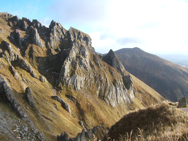
The Massif Central is an ancient block of continental crust, a classical example of an old European massif. Its roots lie in Precambrian and early Palaeozoic events: the crystalline basement contains granites and metamorphic rocks typical of old orogenic belts. Much of this foundation dates to deep time, including Proterozoic components, and was strongly reworked during the Variscan orogeny. Subsequent erosion and later tectonic phases have left remnants of that long history, with exposures of granitic and metamorphic rocks at the surface.
Uplift, erosion and more recent events
Although ancient, parts of the massif appear comparatively youthful because of renewed uplift and the influence of neighbouring chains: the rise of the Alps and regional Cenozoic movements modified slopes and drainage patterns, particularly during the Paleogene and later intervals. These episodes reactivated faults and contributed to the distinctive plateaux, valleys and escarpments seen today.
Volcanism
One of the region's best-known features is widespread volcanic activity during the Neogene–Quaternary: large numbers of now-extinct volcanic cones, lava domes and basaltic plateaux occur, especially in the Auvergne sector. The chain known as the Chaîne des Puys and the protected areas such as the Auvergne volcanoes illustrate this volcanic heritage. These volcanic forms create local high points and fertile soils that influence pastures and agriculture.
Rivers, ecology and human use
The Massif Central is an important watershed: several major French rivers rise on its slopes and flow to all sides of the country. Its mosaic of heath, pasture, forest and cultivated land supports a range of habitats and traditional pastoral activities. Low population density in many parts has preserved significant natural and semi-natural landscapes, while valleys host towns, transport routes and diversified farming.
Conservation, tourism and economy
Protected sites, regional parks and nature reserves aim to balance conservation and local livelihoods. The massif attracts hikers, geotourists and winter visitors to modest ski areas; cultural tourism highlights rural architecture, cheeses and folk traditions. Scientific interest focuses on its long geologic record and the well-preserved volcanic features.
Administrative departments
The Massif Central spans many French departments; the following are commonly associated with the region:
For readers seeking maps, geological summaries or visitor information, consult regional guides and the specialist literature. The Massif Central remains a key area for understanding Europe's geological past, regional biodiversity and longstanding rural cultures.
Geographical location
The Massif Central is located to the west of the Rhone and is roughly bounded by the cities of Limoges, Clermont-Ferrand, Lyon, Nîmes, Béziers, Toulouse, Cahors, Périgueux and Angoulême; thus the Massif extends to the regions of Auvergne-Rhône-Alpes, Nouvelle-Aquitaine and Occitanie. There, it includes all or part of the departments of
- Auvergne-Rhône-Alpes: Ardèche, Loire, Rhône, Allier, Cantal, Haute-Loire and Puy-de-Dôme,
- Nouvelle-Aquitaine: Corrèze, Creuse, Haute-Vienne and Dordogne (partly),
- Occitania: Aveyron, Lot (partly), Tarn, Gard, Hérault and Lozère.
The largest cities located in the massif or on its edge are Saint-Étienne, Clermont-Ferrand and Limoges. Several stages of the Tour de France regularly take place here.
Geology of the Massif Central
See also: Geology of the Massif Central
The earliest geological traces can be dated to about 550 million years ago. In this period of the early Cambrian, the Massif Central seems to have been part of a large sill system separating two seas. Ablation debris is preserved here, partly interbedded with granitic intrusions. In the Ordovician, in the period from about 480 to 440 million years ago, a trench deepened and widened to form a broad ocean, in which mainly thick layers of clayey deep-sea sediments were deposited. 420 million years ago, at the threshold of the Silurian to the Devonian, Gondwana moved closer to central Europe again. Most of the seafloor was subducted and some of the sedimentary cover was also shifted. With that a huge fold mountain range, the Variscan Mountains, rose. It stretched across the entire (today's) eastern edge of North America, which at that time bordered Europe, across central to eastern Europe, and was probably much more immense than today's Alps. Sediments were transported to great depths and metamorphosed. Magma rose at the subduction zone.
As soon as the Variscan mountains rose, they already began to erode. Massive layers of debris were deposited in the foreland, which the meandering rivers turned into a swamp. This took place in the Carboniferous. Vast lush Carboniferous forests developed in this swamp. Coal layers were formed in these areas.
With the Alpine folding in the Tertiary, a second uplift of the terrain occurred: The collision of the African plate with the Eurasian plate caused seabed, on which limestone layers several hundred metres thick had formed, to be pushed upwards again along with the granite basement. These limestone plateaus form today's Causses, the geologically younger regions of the Massif Central. These were mainly formed in the Mesozoic period - especially in the Jurassic period - and rise in a staircase from northwest to southeast: While in Périgord and Quercy they reach only about 200 metres in height and are therefore not counted as part of the Massif Central proper, in the Lozère department they are over 1000 metres high. Several rivers, in particular the Tarn, have carved gorges of enormous depth between them.
Along a terrain collapse in the north, the Limagne, lava came to the surface again in the late Tertiary. These volcanoes, now extinct, form a mighty chain of steep basalt peaks west of Clermont-Ferrand, the so-called Chaîne des Puys. The most famous volcano is the Puy de Dôme, which gave the department its name.
Related articles
Author
AlegsaOnline.com Massif Central — highlands of south-central France Leandro Alegsa
URL: https://en.alegsaonline.com/art/62703