Mason–Dixon Line
Boundary first surveyed between Maryland and Pennsylvania in the 1760s; a precise colonial-era survey that became a legal, geographical and cultural dividing line in the United States.
The Mason–Dixon line is the historic surveyed boundary originally drawn to settle a colonial border dispute between what became Maryland and Pennsylvania. Work on the line was carried out between 1763 and 1767 by two English surveyors, Charles Mason and Jeremiah Dixon. Commissioned by the proprietors, the survey established a clearly defined border where earlier colonial charters and on-the-ground claims had overlapped. The effort combined astronomical observations, careful chains and measuring instruments of the period to lay out a straight west–east line and associated meridian and tangent lines.
Image gallery
10 Images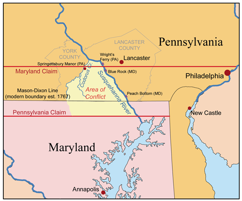


History and survey methods
The need for a formal resolution grew out of long-standing disagreement between the Penn family and the Calvert family over overlapping grants. After intermittent fights and legal wrangling, the British crown insisted the matter be settled; by 1760 the escalation of violence and property conflicts prompted renewed action. Mason and Dixon, both trained as astronomers and surveyors from England, used celestial observations to fix latitude and azimuth, then ran measured lines on the ground. The work required placing mile markers and larger "crownstones" at intervals; many of these original markers survive.
Physical features and markers
The survey comprised a principal east–west line and boundary segments that met colonial goals for county and proprietary limits. Markers included:
- Stone mile markers carved with initials or symbols.
- Crownstones, larger carved stones often bearing a coat of arms for the Penn or Calvert proprietors.
- Survey notes and astronomical records kept by Mason and Dixon, which validate the original positions.
Legal and cultural significance
Although intended simply to settle property and jurisdictional questions, the Mason–Dixon line later took on broader meaning. By the 19th century it had become a widely recognized cultural boundary between the free states of the North and the slaveholding states of the South. As such, references to "north of the Mason–Dixon" or "below the Mason–Dixon" entered political and literary usage. Legally the line still serves in part to define state borders but it is primarily a historical and symbolic reference today.
Accuracy and legacy
Mason and Dixon's work is notable for its precision. Modern surveys and satellite positioning have shown the original line to be remarkably accurate; reports note deviations as small as an inch in places and up to several hundred feet in others, reflecting both the quality of 18th‑century fieldwork and later measurement differences. The Mason–Dixon line remains studied by historians, surveyors and preservationists; many of its stones are protected as historic artifacts and visited by those interested in colonial science, boundary law and American cultural geography. For additional background and archival material see contemporary collections and regional historical societies that house the original field books and correspondence about the survey (surveyed records and reports).
Further reading and resources may be found through state archives and specialized research institutions: documents relating to the original dispute and its resolution illuminate the practical, legal and scientific challenges of running a major colonial boundary. For genealogical, legal or survey inquiries consult repositories associated with the Penn and Calvert proprietorships as well as modern state survey offices and historical commissions (border dispute, boundary studies).
Researchers and visitors can locate surviving markers and interpretive displays maintained by local groups and parks; these sites interpret both the technical achievement of Mason and Dixon and the line's later role in American history. Many educational pages and local histories provide maps, photographs and transcriptions of the stones (regional resources, field notes).
Questions and answers
Q: What is the Mason-Dixon line?
A: The Mason-Dixon line is a border between Maryland and Pennsylvania that was surveyed and marked between 1763 and 1767.
Q: Who were Charles Mason and Jeremiah Dixon?
A: Charles Mason and Jeremiah Dixon were two English surveyors who were hired by the Penn and Calvert families to settle a border dispute between Maryland and Pennsylvania.
Q: Why was the Mason-Dixon line created?
A: The Mason-Dixon line was created to settle a border dispute between Maryland and Pennsylvania.
Q: When was the Mason-Dixon line surveyed and marked?
A: The Mason-Dixon line was surveyed and marked between 1763 and 1767.
Q: What did the British crown demand in 1760?
A: In 1760, the British crown demanded that the dispute over the border between Maryland and Pennsylvania be settled according to an agreement made in 1732.
Q: How accurate is the Mason-Dixon line?
A: The line the two surveyors came up with was so accurate that it is still considered a marvel. GPS measurements show the line to be off by an inch (2.54 cm) or less in places and no more than 800 feet (240 m) in others.
Q: Who hired Charles Mason and Jeremiah Dixon to settle the border dispute?
A: The Penn and Calvert families hired Charles Mason and Jeremiah Dixon to settle the border dispute.
Related articles
Author
AlegsaOnline.com Mason–Dixon Line Leandro Alegsa
URL: https://en.alegsaonline.com/art/62651
Sources
- www1.udel.edu : "A brief history of the Mason-Dixon Line"
- history.com : "1767 Mason and Dixon draw a line"
- surveyorshistoricalsociety.com : "Drawing the Line"
- news.nationalgeographic.com : "Saving the Mason-Dixon Line"
- heritage.nf.ca : "Sir George Calvert and the Colony of Avalon"
- ushistory.org : "Brief History of William Penn"
- mapsofpa.com : "Placing Pennsylvania on the Map: The First Steps"
- lancasterhistory.org : "The River as Barrier and Boundary: Cresap's War"
- risingsunmd.org : "History of the Mason-Dixon Line"
- slavenorth.com : "Slavery in Delaware"
- geography.about.com : "Mason-Dixon Line"