Mark Twain National Forest
Overview of Mark Twain National Forest: geography, history, ecology, ranger districts, recreation, notable features (Greer Spring, Eleven Point, Glade Top Trail) and visitor guidance.
Mark Twain National Forest is a U.S. National Forest located primarily in the southern portion of Missouri. Established on September 11, 1939, it was named in honor of the writer Mark Twain (Samuel Clemens), whose life and work are closely associated with the state. The forest is a scattered collection of tracts that together total roughly 1,491,840 acres, including more than 78,000 acres designated as wilderness and additional river corridors protected for scenic and ecological values (wilderness and rivers).
Image gallery
3 Images

Geography and landscape
Mark Twain National Forest occupies parts of the Ozark Highlands and is found across 29 counties in the southern half of Missouri. The landscape includes oak–hickory forests, glades and prairie remnants, steep ridges, and characteristic karst terrain with springs, caves and sinkholes. Cold-water streams and clear rivers cross the forest, supporting diverse fish and other aquatic life. Collectively, forest lands in the Mark Twain complex represent a significant share of the state’s forested area (Missouri forestland).
Organization and management
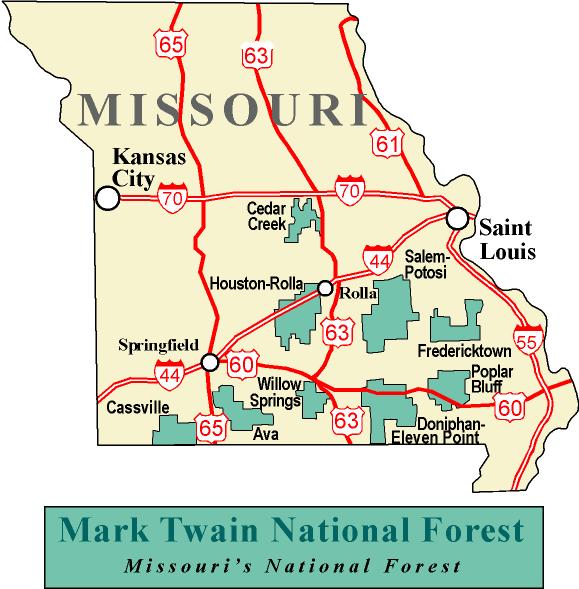
Administration of the forest is organized into ranger districts that handle local stewardship, recreation, timber management, and conservation programs. The national forest has six named ranger districts—often described as covering nine non-contiguous tracts—and the primary administrative headquarters is located in Rolla, at the forest office (Rolla, Missouri). The ranger districts include the Ava-Cassville-Willow Springs district, Eleven Point, Houston-Rolla-Cedar Creek, Poplar Bluff, Potosi-Fredericktown, and Salem. Each district manages trail maintenance, visitor services, and habitat projects appropriate to its local conditions.
Notable natural features
The Mark Twain contains several prominent springs, rivers and scenic corridors. Greer Spring is the largest spring on national forest land and is a major source for the Eleven Point River, averaging an output often cited near 214 million gallons per day. The Eleven Point River includes stretches recognized as a National Scenic River and retains wilderness character in places. The Glade Top Trail National Scenic Byway crosses the forest and offers panoramic views that extend to the Boston Mountains of Arkansas on clear days.
Ecology and wildlife
The forest supports a mixture of oak, hickory, shortleaf pine and glade-adapted species. Habitats range from mature woodlands to open glades that host specialized plants and pollinators. Wildlife includes white-tailed deer, wild turkey, numerous songbirds and a variety of amphibians tied to the forest’s springs and streams. Management objectives emphasize habitat diversity, protection of native species, control of invasive plants, and restoration where soils or vegetation were previously altered.
Recreation and public use
Recreational opportunities are broad: hiking and backpacking on segments of the Ozark Trail, dispersed camping, hunting and fishing, birdwatching, horseback riding, and paddling on designated river sections. Portions of the long-distance Ozark Trail system traverse forest territory and connect trail segments through rugged ridges and glades. Scenic byways, developed overlooks and spring sites such as Greer Spring are popular destinations for day visitors and outdoor photographers.
History and stewardship
Created during the federal conservation movement of the 1930s, the forest was established to bring coordinated management to lands affected by early logging and soil erosion. Since then, stewardship has balanced sustainable timber production with recreation infrastructure, watershed protection, cultural resource preservation, and the restoration of native plant communities. Ongoing programs include prescribed burning, reforestation, trail maintenance and collaborations with local communities and volunteers.
Visiting and safety
Visitors are encouraged to plan ahead: check local conditions, seasonal access, and any restrictions by contacting the forest headquarters or local ranger district offices. Pack appropriate gear, practice Leave No Trace principles, respect wildlife, and be cautious around springs and riverbanks where slippery rock and swift flows can present hazards. For maps, permits, trail updates and educational resources, contact the Rolla office or consult official Forest Service materials and regional visitor guides (Rolla office, regional pages).
Research, partnerships and conservation
Mark Twain National Forest participates in research, conservation partnerships and volunteer programs that support biodiversity and sustainable recreation. State and federal agencies, universities and nonprofit organizations often collaborate on species monitoring, invasive species control, habitat restoration and public education projects. These cooperative efforts help preserve the forest’s ecological values while supporting local economies through nature-based tourism and traditional uses.
For additional authoritative information about regulations, current conditions, and special designations in the Mark Twain National Forest, consult ranger district contacts and official resources maintained by the U.S. Forest Service (wilderness information, district contacts, county listings).
Questions and answers
Q: What is Mark Twain National Forest?
A: Mark Twain National Forest (MTNF) is a US National Forest located mainly in the southern half of Missouri.
Q: When was it established?
A: The MTNF was established on September 11, 1939.
Q: Who is it named after?
A: It is named for author Mark Twain, a Missouri native.
Q: How big is the forest?
A: The MTNF covers 1,491,840 acres (6,037.3 km2), 78,000 acres (320 km2) of which are wilderness and National Wild and Scenic River area.
Q: How many counties does it span?
A: MTNF spans 29 counties.
Q: What percentage of all forested land in Missouri does it represent?
A: It represents 11% of all forested land in Missouri.
Q: What are some unique features of the Mark Twain National Forest?
A: Some unique features of the Mark Twain include Greer Spring which is the largest spring on National Forest land and part of the Eleven Point National Scenic River; Glade Top Trail National Scenic Byway which offers views over 30 miles to the Boston Mountains in Arkansas; and part of the Ozark Trail system winds through the national forest.
Related articles
Author
AlegsaOnline.com Mark Twain National Forest Leandro Alegsa
URL: https://en.alegsaonline.com/art/62101
Sources
- dnr.mo.gov : "Water Resources Center - DNR"
- fs.usda.gov : "Recreation"
- fs.fed.us : Table 6 - NFS Acreage by State, Congressional District and County
- commons.wikimedia.org : Mark Twain National Forest