Arrondissements of the Deux-Sèvres department
Overview of the three arrondissements in Deux-Sèvres: their role, organization, brief profiles of Niort, Bressuire and Parthenay, and historical and administrative context.
The department of Deux-Sèvres in west‑central France is divided into three administrative arrondissements. In the context of the French territorial system, a department — one of the country’s principal territorial units, often called departments — is in turn organised into arrondissements, which can be translated in English as districts and sometimes as boroughs. Each arrondissement has a chief town that functions as its administrative centre, known as a subprefecture when it is not the departmental capital.
Image gallery
1 Image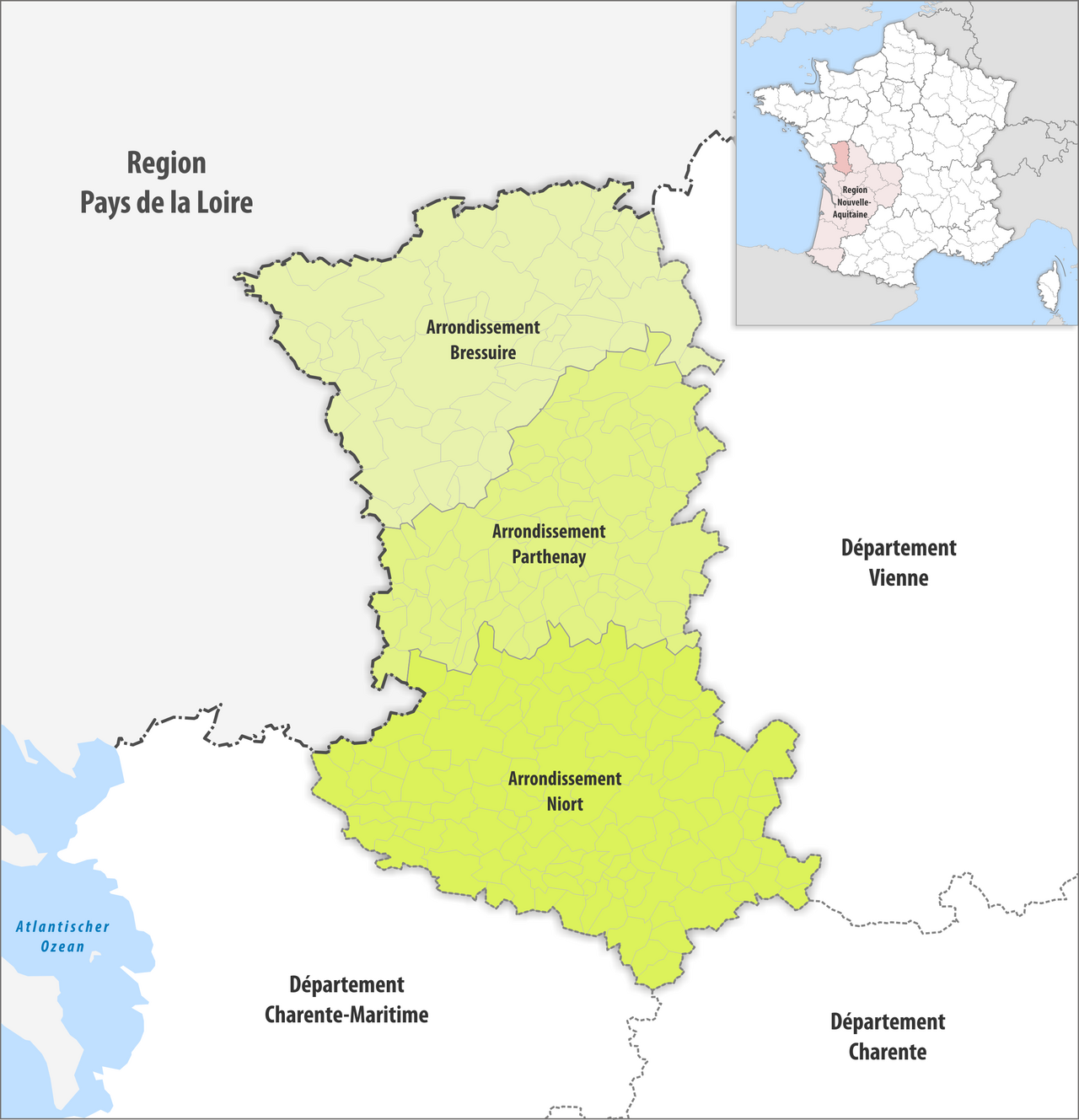
Structure and purpose
Arrondissements are not autonomous political entities but serve as units for state administration and coordination. They bring together many local governments and public services, help implement national policies locally, and provide a level for statistical reporting. Below arrondissements are the smaller communes, which are the basic units of local government in France.
The three arrondissements
- Niort — the prefecture of the department and the largest urban centre. Niort acts both as the departmental capital and as the seat of its arrondissement.
- Bressuire — a subprefecture in the northern part of the department, centred on a market town with local historical and agricultural ties.
- Parthenay — a subprefecture to the west, known for its medieval streets and role as a local administrative hub.
Each arrondissement groups numerous communes and communes are the level at which mayors and municipal councils exercise daily local governance. Although arrondissements do not have an elected council, the subprefect represents the state within the arrondissement and coordinates activities among national services.
History and development
The present arrondissement structure dates from reforms initiated after the French Revolution and consolidated during the early 19th century. Over time, arrondissement boundaries and the number of subprefectures have been adjusted across France to reflect population changes and administrative reforms. In Deux‑Sèvres, the three arrondissements evolved from these historical reorganisations and continue to reflect the department’s geographic and economic patterns.
Uses and notable facts
Arrondissements are widely used for administrative convenience: judicial organisation, statistical reporting by national agencies, civil protection planning and the delivery of certain public services. Niort, as the departmental prefecture, is also a regional economic centre noted for its service sector. Understanding the arrondissement map is useful for public administration, regional planning and for residents navigating administrative procedures.
For further information about territorial organisation and local services consult official departmental and national sources or local prefecture communications.
Questions and answers
Q: How many arrondissements are in the Deux-Sèvres department?
A: There are 3 arrondissements in the Deux-Sèvres department.
Q: What are arrondissements?
A: Arrondissements are divisions within French departments that may be translated as districts or boroughs in English.
Q: What is the capital of an arrondissement called?
A: The capital of an arrondissement is called a subprefecture.
Q: What happens if the capital of a department is in an arrondissement?
A: If the capital of a department is in an arrondissement, that prefecture becomes the capital of the arrondissement, acting as both a prefecture and a subprefecture.
Q: What are arrondissements further divided into?
A: Arrondissements are further divided into communes.
Q: What are the arrondissements of Deux-Sèvres?
A: The arrondissements of Deux-Sèvres are not provided in the text.
Q: Can arrondissements be found outside of France?
A: Yes, arrondissements can be found in other countries as well.
Related articles
Author
AlegsaOnline.com Arrondissements of the Deux-Sèvres department Leandro Alegsa
URL: https://en.alegsaonline.com/art/6112
Sources
- insee.fr : "Département des Deux-Sèvres (79)"
- insee.fr : "Régions, départements, arrondissements, cantons et communes"
- insee.fr : "Département des Deux-Sèvres (79)"
- splaf.free.fr : "Historique des Deux-Sèvres"