Magdeburg — capital of Saxony-Anhalt in Germany
Magdeburg is the largest city and capital of Saxony-Anhalt, Germany. Known for its medieval history, the Magdeburg hemispheres demonstration, and as the birthplace of composer Georg Philipp Telemann.
Magdeburg is a German city serving as the capital of the state Saxony-Anhalt. It lies in central Germany on the Elbe River and has been an important regional center for administration, commerce and culture. The urban area covers roughly 201 km² (about 77.6 sq mi) and had a population of approximately 236,000 in the mid-2010s.
Image gallery
10 Images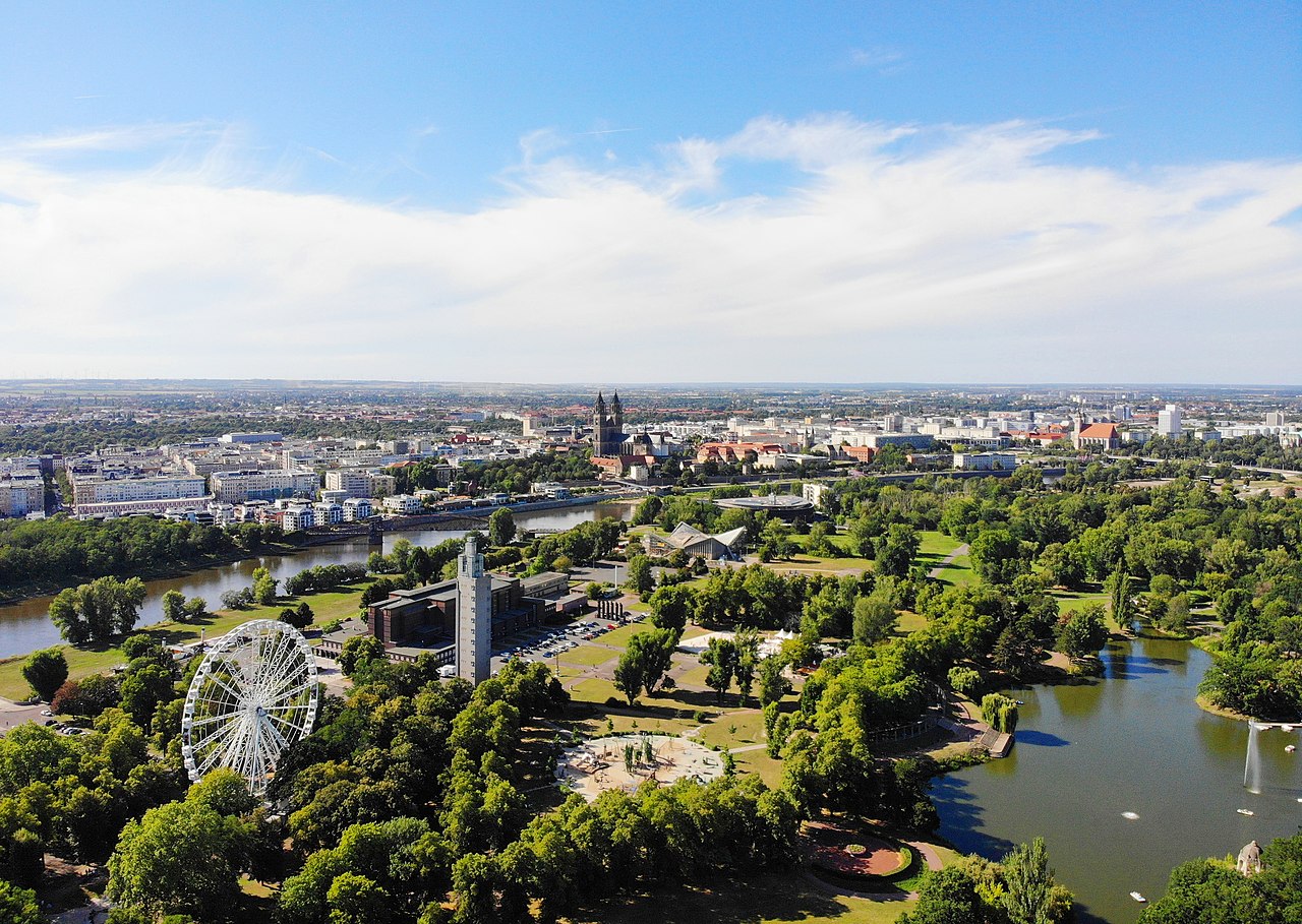


Geography and character
Situated on the banks of the Elbe, Magdeburg mixes riverfront districts, parks and industrial zones. Its location has influenced trade routes and transport links for centuries, and the city today connects by rail and highway to other parts of Germany. The surrounding region includes agricultural land and smaller towns that rely on Magdeburg as an economic and civic hub.
History and development
Magdeburg dates back to the early Middle Ages and became notable as a center of trade and law. The city gave its name to the “Magdeburg rights,” a set of municipal laws that influenced urban governance in Central and Eastern Europe. Over its history Magdeburg has experienced periods of prosperity and severe destruction; it was famously sacked during the Thirty Years' War in the 17th century and later suffered extensive damage during the Second World War. Reconstruction and modernization in the postwar era reshaped much of its urban fabric.
Culture, science and notable figures
The city has a long cultural tradition. It is the birthplace of the Baroque composer Georg Philipp Telemann and was home to scientists and inventors. In the mid-17th century a scientist and civic leader, Otto von Guericke, carried out a famous public experiment demonstrating atmospheric pressure using large copper hemispheres — often referred to as the Magdeburg hemispheres; descriptions of this demonstration remain a regular reference in histories of science.
Economy and modern role
Today Magdeburg functions as an administrative capital with a diversified economy that includes manufacturing, services, research and higher education. It hosts regional institutions and cultural venues that serve the wider state; the local university and technical institutes contribute to research and training, while river transport and logistics continue to be important.
Notable facts and visiting
- The city center mixes medieval landmarks with 20th-century reconstruction.
- Magdeburg’s historical significance includes legal traditions and scientific demonstrations that reached beyond its borders.
- Visitors can explore museums, the cathedral precinct and riverfront spaces reflecting the city’s layered past and contemporary life; municipal resources and tourism information are maintained by the state authorities.
For further reading on regional context and contemporary statistics see linked resources and regional guides; local archives preserve extensive material on Magdeburg’s civic, cultural and scientific heritage (regional page, national overview).


Geography
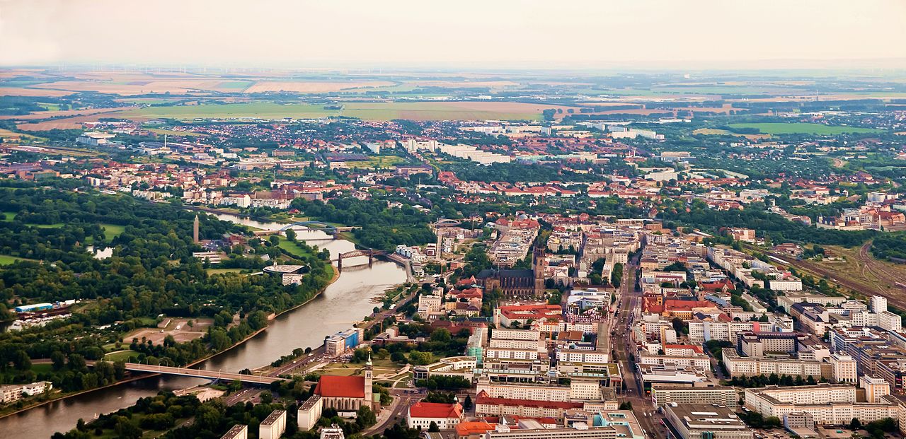
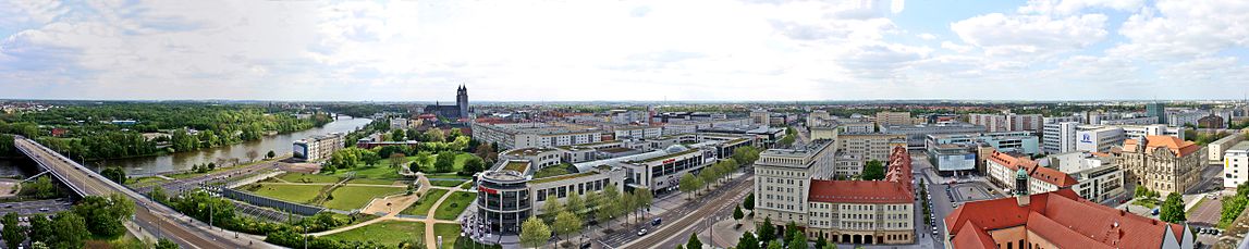
The independent city in the centre of Saxony-Anhalt lies on the middle Elbe and on the eastern edge of the landscape Magdeburger Börde on old cultural soil and forms the centre of the region Magdeburg (also called Elbe-Börde-Heide). The centre of Magdeburg is determined by the foot of the northern cathedral spire, which is 56 m above sea level. Magdeburg's highest elevation at the Hängelsberge, which belongs to the hill chain of the Börde, is 124 m above sea level, the lowest point is 40.8 m above sea level.
The city extends mainly on the western high bank of the river on a terrain formed by the Domfelsen (sandstones and siltstones of the Rotliegende in extension of the Flechtinger Höhenzug). Magdeburg is one of the few cities in the North German Plain that is founded on rock, in addition to greywacke, a sandstone sedimentary rock of the Palaeozoic Era, and to a lesser extent on pitchstone and glacial flint deposits. Part of the town area lies on an elongated island between the "Strom-Elbe" and the "Alte Elbe" and on the shallow eastern bank of the river. The area of the city territory is about 201 km², the city longitude border including exclaves is 89.9 km long. 27.1 km of it border on the Jerichower Land, 18.3 km on the Salzlandkreis and 44.5 km on the Landkreis Börde.
Typical of large eastern German cities, Magdeburg does not have a distinct suburban belt and is not located directly in a conurbation. However, as the city acts as a major development engine for the surrounding region, it is classified as a regiopolis. The nearest major cities are Wolfsburg about 64 kilometres to the northwest, the twin city of Braunschweig about 75 kilometres to the west, Halle (Saale) about 75 kilometres to the south and Potsdam about 105 kilometres to the east. Berlin is 130 kilometres to the east.
The Stromelbe crosses Magdeburg over a length of 21.1 km and the Alte Elbe over 5.3 km. Its gauge zero at the Strombrücke is 39.99 m above sea level. The city also has several lakes, including the Salbker Seen (together 51.7 ha) or the Barleber See I (103 ha) and II (71.9 ha).
According to a study from the first quarter of 2007, Magdeburg has the second largest proportion of public green spaces in its urban area after Hanover among the 50 largest German cities.
enlarge and show information about the picture
![]()
Magdeburg panorama seen from the St.-Johannis-Church
Neighboring communities
The following municipalities, named clockwise starting in the northeast, border the city of Magdeburg:
- in the district of Jerichower Land: Möser, Biederitz, Gommern
- in the Salzlandkreis: Schönebeck and Bördeland
- in the rural district of Börde: Sülzetal, Wanzleben-Börde, Hohe Börde, Barleben and Wolmirstedt
Around 297,000 people live in the Magdeburg conurbation (agglomeration).
Protected areas
So far, 160 protected biotopes have been recorded in the area of Magdeburg, including moors, swamps, swamp, gully and riparian forests, groups of pollarded trees, hedges and spring areas.
The "Kreuzhorst Nature Reserve" in Magdeburg is intended to protect nature and the landscape and to preserve and develop habitats. In the middle Elbe lowlands, it comprises one of the few near-natural floodplain forest complexes. It is predominantly covered by a forest of pedunculate oaks and ash trees. So far, 32 mammal species, 16 of which are on Saxony-Anhalt's Red List, three reptile and twelve amphibian species, six of which are endangered, eleven fish species, around 3000 butterfly species and 168 weevil species are listed in the nature reserve. Worth mentioning is the occurrence of stag beetles, herdbucks, ibex, an endangered species, Elbe beavers and the endangered polecat.
The Middle Elbe Biosphere Reserve is the habitat of many endangered animal species and is of high ecological value due to the large number of oxbow lakes. It extends over parts of the floodplain and east of the flood dike.
Furthermore, Magdeburg has several protected parks, such as the "Goethe-Anlagen" or the "Schneiders Garten", a biosphere reserve and protected waters.
See also: List of nature reserves in the city of Magdeburg
Climate
The average annual precipitation of Magdeburg is about 500 mm. Compared to the average for Germany as a whole, this is considered low; the city is still in the rain shadow of the Harz Mountains. The average temperature in Magdeburg is 8.8 °C, which is within the national average. The driest month is February, the month with the most precipitation is June. The warmest month is July, the coolest month is January according to statistics.
| Magdeburg | ||||||||||||||||||||||||||||||||||||||||||||||||
| Climate diagram | ||||||||||||||||||||||||||||||||||||||||||||||||
| ||||||||||||||||||||||||||||||||||||||||||||||||
| Monthly average temperatures and precipitation for Magdeburg
Source: DWD; wetterkontor.de | ||||||||||||||||||||||||||||||||||||||||||||||||||||||||||||||||||||||||||||||||||||||||||||||||||||||||||||||||||||||||||||||||||||||||||||||||||||||||||||||||||||||||||||||||||||||||||||||||||||||||||||||||||||||||||||||||||||||||||||||||||||||||||||
City breakdown
The city of Magdeburg is divided into 40 districts. In all districts there are further subdivisions that have become naturalized in the course of history. These are mostly new housing estates or residential areas, whose boundaries can be quite fluid.
|


Religions
Confession statistics
In 2003, 8.8% of the population were Protestant, 4.3% Catholic and 86.9% belonged to another denomination/religion or were non-denominational. In 2015, 8.4% were Protestant, 3.6% were Catholic, and 88.0% belonged to another denomination/religion or were non-denominational. In 2018, 8.2 % were Protestant
In addition to the two "big churches", there are several free churches (0.6%) and other religious groups in Magdeburg, including an Islamic community and two Jewish communities (0.3%). The latter is mainly composed of immigrants from the former Soviet Union and has about 850 members. The Magdeburg synagogue community is one of the largest Jewish communities in eastern Germany with about 600 members.
Church History
The city of Magdeburg initially belonged to the diocese of Halberstadt. In 937, the St. Moritz monastery was founded in Magdeburg, which was converted into a cathedral chapter in 962. Thus the archbishopric of Magdeburg was founded. A second document founding the archbishopric dates from 968. The archbishopric of Magdeburg initially included the suffragans of Merseburg, Zeitz-Naumburg, Meissen, Brandenburg and Havelberg, with Meissen leaving in the 15th century. Furthermore, the mendicant orders of the Franciscans (Franciscan monastery Magdeburg 1223) and Dominicans (Dominican monastery Magdeburg 1224) founded important branches and studies in Magdeburg, which existed until the introduction of the Reformation.
Protestant churches
In 1521 the first Protestant sermon was preached in Magdeburg. Three years later, the council introduced the Reformation throughout the city. In 1563 the archbishop also converted to the Lutheran doctrine and in 1567 the first Protestant sermon was held in the cathedral. The few Catholics remaining in the city were cared for by the Agneten Monastery in Neustadt. In 1628 this monastery of Our Lady in Magdeburg was recatholicised. Reformed Huguenots settled in the town from 1685, and Reformed Palatines from 1689, so that two Reformed congregations soon arose, which formed their own political communities. After the transition to Prussia and the unification of Lutheran and Reformed congregations within Prussia into a unified national church (Uniate Church) in 1817, the Protestant congregations of Magdeburg belonged to the Evangelical Church in Prussia or its subdivision Church Province of Saxony, whose secular head was the respective King of Prussia as summus episcopus, the spiritual leadership was held by general superintendents.
After the abolition of the sovereign church regiment in 1918, the Evangelical Church in Prussia changed its church order accordingly in 1922 and then called itself the Evangelical Church of the Old Prussian Union, while retaining the church province of Saxony. In 1947 this became an independent regional church, the Evangelical Church of the Church Province of Saxony with a bishop at its head. Its episcopal church is the Magdeburg Cathedral. On 1 January 2009, the Evangelical Church of the Church Province of Saxony and the Evangelical Lutheran Church in Thuringia merged to form the Evangelical Church in Central Germany (EKM). The bishop's seat of the EKM is Magdeburg, where the first female bishop in eastern Germany, Ilse Junkermann, took office on 29 August 2009.
Until 2008, the Protestant parishes of Magdeburg belonged to the church district of Magdeburg within the provostry of Magdeburg-Halberstadt, whose seat was also in Magdeburg, unless they were congregations of the Independent Evangelical Lutheran Church or the Protestant free churches. Since the formation of the EKM in 2009, the church district of Magdeburg belongs to the provost's parish of Stendal-Magdeburg with its seat in Stendal. The Protestant Reformed congregation of the city belongs to the Reformed Church District within the EKM.
In addition, there are several Protestant free churches in Magdeburg: the Methodists, the Baptists and the Seventh-day Adventists.
Roman Catholic Church
In the 19th century the number of Catholics increased for the first time after the Reformation. From 1821 they belonged to the diocese and from 1930 to the archdiocese of Paderborn. After the Second World War it became increasingly difficult for the archbishop to carry out his official duties in the eastern part of his archdiocese. Therefore, in 1946 a vicar general was appointed in Magdeburg, who was appointed auxiliary bishop in 1949. Due to the reorganization of the Catholic Church in the GDR, the areas were formally separated in 1972 and elevated to an episcopal office. The head of this office became a bishop directly subordinate to the Holy See with the title Apostolic Administrator. On 8 July 1994 the former Episcopal Office of Magdeburg was elevated to the status of a diocese and again placed under the Archdiocese of Paderborn as a suffragan bishopric. The parishes of Magdeburg thus belong to the deanery of Magdeburg within the diocese of the same name. Closely connected with the pastoral efforts are the social initiatives of the Catholic Church. Thus the community of the Poor Handmaids of Jesus Christ from Dernbach (Westerwald) with the branch St. Agneshaus was settled here. It existed from 22 October 1911 until 8 October 1981. The sisters ran a kindergarten, provided outpatient nursing and pastoral care.
Jehovah's Witnesses
Magdeburg plays a special role in the history of Jehovah's Witnesses in Germany. In the years 1923 until its destruction by the National Socialists in 1933, the German branch office of the religious community was located in today's Emanuel-Larisch-Weg (at that time "Watchtower Street"). After the war, activities were resumed, but were again banned in 1950. In 1993, the Watchtower Society received a large part of its former property back. Today there are four congregations in Magdeburg, which operate two Kingdom Halls.


Related articles
Author
AlegsaOnline.com Magdeburg — capital of Saxony-Anhalt in Germany Leandro Alegsa
URL: https://en.alegsaonline.com/art/60570