Mackenzie Large Igneous Province (MLIP)
A Mesoproterozoic continental flood basalt province in Canada, formed about 1.27 billion years ago; dominated by the Mackenzie dike swarm, Coppermine flood basalts and related intrusions.
Overview
The Mackenzie Large Igneous Province (MLIP) is a vast Mesoproterozoic magmatic region in northwestern Canada formed around 1,270 million years ago. It comprises an extensive network of mafic igneous rocks produced during a geologically brief, high-volume igneous event. The MLIP is notable as one of the largest and best-preserved continental flood basalt provinces on Earth and is a key example used to study continental magmatism and mantle processes in the Proterozoic era. Mesoproterozoic age constraints and regional mapping place the province across multiple modern territories of Canada, including Arctic and sub-Arctic regions.
Image gallery
4 Images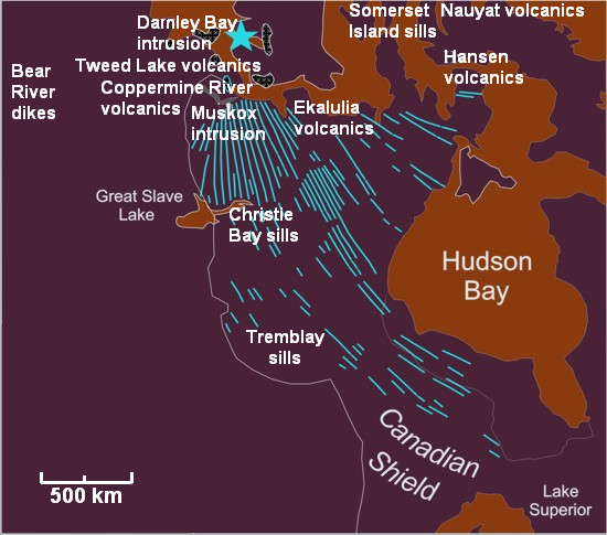


Components and distribution
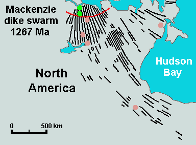
The province contains three main types of expression: a radial dyke swarm, voluminous flood basalts, and associated layered intrusions. The Mackenzie dyke swarm alone occupies an enormous area and can be traced for more than a million square miles across the Canadian Shield. Closely associated are the Coppermine River flood basalts and the Muskox layered intrusion, among other mafic bodies. These elements together extend from the Arctic coast in Nunavut through the Northwest Territories and toward northwestern Ontario near the Great Lakes region.
- Dyke swarm: a radial pattern of feeder dykes that radiate from a central source region and record the outward transport of magma through the crust (dike swarm).
- Flood basalts: extensive sheet-like lava flows, often basaltic in composition (Coppermine basalts).
- Layered intrusions: large gabbroic bodies that crystallized slowly at depth and display internal layering (Muskox intrusion).
Age, origin and geology
Radiometric dating and field relations indicate an emplacement age of about 1.27 billion years. The MLIP is widely interpreted to have formed in response to a mantle plume or hotspot event rather than by routine plate-boundary seafloor spreading. That pulse of upwelling mantle produced vast volumes of mafic magma (basalt and gabbro) and created the characteristic radial geometry of dykes and the large surface outpourings of flood basalt. Geophysical surveys, including aeromagnetic data, reveal the linear magnetic signatures of dykes and offer a means to map their subsurface extent beyond exposed outcrops (geophysics).
Characteristics and composition
Rocks of the MLIP are dominantly mafic—basalts at the surface and gabbros in deeper intrusions—and they commonly show compositions consistent with derivation from a relatively primitive mantle source. The province illustrates how large-volume mafic magmatism can modify continental crust and leave long-lived geological structures. Because emplacement was relatively rapid on geological timescales, many parts of the province preserve primary features such as flow structures, chilled margins, and contacts between intrusive bodies.
Significance, research and resources
The MLIP is important for understanding Proterozoic mantle dynamics, continental break-up processes, and the environmental consequences of large igneous events. It is also significant in economic geology: layered mafic intrusions and associated sulphide concentrations may host concentrations of nickel, copper and platinum-group elements—types of mineralization commonly investigated in similar provinces worldwide. Ongoing studies use field mapping, geochemistry, geochronology and geophysics to clarify timing, magma sources and crustal interactions (research, geochemistry, geochronology).
Notable comparisons and facts
By standard definitions a large igneous province exceeds 100,000 square kilometres; the Mackenzie dyke swarm alone covers a substantially larger area—on the order of millions of square kilometres—and has been compared in scale to the largest oceanic plateaus. Because of its size and preservation, the MLIP is frequently cited when comparing continental flood basalt provinces and when evaluating mantle plume hypotheses. Modern syntheses and summaries of this province and related provinces are accessible through geological surveys and academic reviews (LIP definitions, comparisons, provincial geology).
For readers seeking more detail, regional maps, stratigraphic descriptions and technical papers document the distribution of individual dykes, the stratigraphy of the Coppermine flows, and the internal structure of layered intrusions. These resources are maintained by geological organizations and university research groups (mapping, stratigraphy, layered intrusions, mineralization studies, aeromagnetic surveys, academic reviews).
Questions and answers
Q: What is the Mackenzie Large Igneous Province (MLIP)?
A: The MLIP is a major Mesoproterozoic large igneous province of southwestern, western and northwestern Canada. It is a group of igneous rocks which were formed during a massive igneous event starting about 1,270 million years ago.
Q: How large is the MLIP?
A: The MLIP occupies an area of at least 2,700,000 square kilometres (1,000,000 square miles), making it larger than the Ontong Java Plateau in the southwestern Pacific Ocean or the U.S. state of Alaska.
Q: What type of rocks are found in the MLIP?
A: Igneous rocks of the Mackenzie Large Igneous Province are generally mafic in composition, including basalt and gabbro.
Q: How long did it take for this huge area to be created?
A: Geologically speaking, this huge area was spewed out in a short time.
Q: What size classification does an area need to meet to be considered a large igneous province?
A: The standard size classification for large igneous provinces is a minimum of 100,000 square kilometres (39,000 square miles).
Q: What processes caused the formation of the Mackenzie Large Igneous Province? A: The formation of the Mackenzie Large Igneous Province was caused by processes other than normal plate tectonics and seafloor spreading.
Related articles
Author
AlegsaOnline.com Mackenzie Large Igneous Province (MLIP) Leandro Alegsa
URL: https://en.alegsaonline.com/art/60356
Sources
- prizemining.com : prizemining.com
- largeigneousprovinces.org : largeigneousprovinces.org/08sep
- platinex.com : Geological Report on the Muskox Property