Lübeck (Luebeck) — Hanseatic city in northern Germany
Lübeck is a historic port city in northern Germany, celebrated for its Hanseatic past, Brick Gothic architecture, UNESCO-listed old town, cultural life, and maritime and commercial heritage.
Overview
Lübeck (sometimes written Luebeck when the character ü is not available) is a city in northern Germany with a population of roughly 210,000. Officially styled Hansestadt Lübeck, the name recalls its leading role within the medieval Hanseatic League. Today it lies within the state administered as Schleswig-Holstein and the region's identity is visible in local dialects and traditions; the state's name is also referenced directly in many administrative contexts (Schleswig-Holstein). The city's written form may be adjusted to Luebeck where special characters are unavailable.
Image gallery
10 Images


Historical development
Lübeck grew in importance from the 12th century as a centre for trade across the Baltic and North Seas. Its position on the Trave estuary made it a natural hub for merchants who formed networks that later became the Hanseatic League. In later periods Lübeck retained political autonomy as the Free City of Lübeck and for a time was a separate state within the German political landscape, including during the era of the Weimar Republic (Free City status). The memory of these roles remains visible in the city name and many preserved civic structures.
Architecture, heritage and landmarks
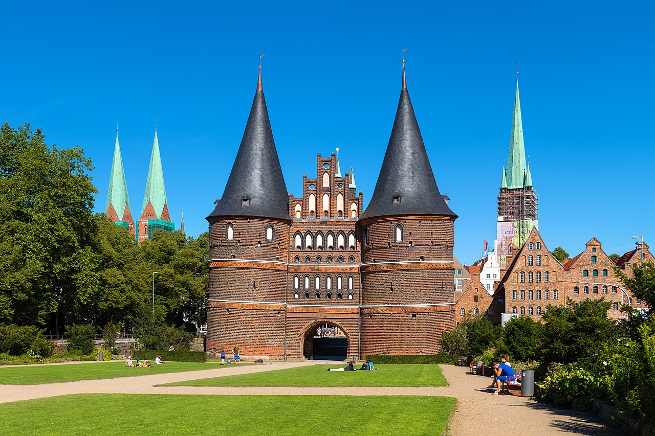
The historic core of Lübeck sits on an island formed by the Trave and its branches. Its medieval townscape is noted for Brick Gothic buildings, tall church towers and narrow lanes. The old town was inscribed as a UNESCO World Heritage Site for its exceptionally intact ensemble of medieval architecture. Notable monuments include the Holstentor gate, St. Mary's Church (Marienkirche) and the Rathaus, and the city is also known for traditional products such as marzipan. Visitors often explore the waterfront, museum houses and churches that recall Lübeck's mercantile past.
Cultural life, education and notable people
Lübeck has a lively cultural scene with theatres, museums and festivals. It hosts institutions of higher learning, such as the University of Lübeck, which focuses on medicine and computer science, and other research and applied-science schools (university). The city is associated with several writers and artists; perhaps its most internationally famous native is the author Günter Grass, who received international honours including the Nobel Prize in Literature (Nobel Prize).
Economy, transport and climate
Lübeck's economy combines tourism, light industry, services and logistics. The port and ferry connections keep maritime links alive, while the old town attracts cultural tourism year-round. The local climate is temperate maritime, classified as oceanic (Cfb in Köppen terms), which moderates seasonal extremes and supports the coastal environment. Modern transport links tie Lübeck to nearby cities and the wider Baltic region.
Context and related Hanseatic cities
As a leading medieval trading city Lübeck is often mentioned alongside other Hanseatic towns that preserve similar heritage. Examples of these cities include Hamburg, Rostock, Wismar, Stralsund, Bremen, Greifswald and Demmin. These places share architectural traits and a historical orientation toward maritime trade, and many have preserved Hanseatic symbols and civic records.
- Useful links and topics: spelling and diacritics (ü / ue), national context Germany, state information Schleswig-Holstein, regional identity Schleswig-Holstein.
- Historical and political context: Hanseatic League, Free City history.
- Culture and education: University, notable author Günter Grass (Nobel).
- Climate classification: oceanic (Cfb).
Lübeck remains an important reference point for northern European commerce and culture, its compact medieval centre and coastal setting making it a frequent subject of preservation, study and tourism.


Geography
General
The city is located in the North German Plain on the lower Trave, a navigable river that flows into the Baltic Sea about 17 km from the old town in the Travemünde district. The city area has approximately a maximum extension of 29 km (axis NE-SW) and 15 km (axis NW-SE). It lies in the Lübeck Basin between the Baltic Sea coast and Lake Ratzeburg (Rothenhusen). The old town is situated on a hill of almost two square kilometres, which forms a marsh between the watercourses of the Trave and the Wakenitz. With the cutting of the "Kanaltrave" in the north at the end of the 19th century, the old town then became an island. The maximum natural elevation of the old town hill is about 30 m above sea level (Marienkirche), the highest natural elevation in the town area is in the Waldhusen forest at about 38 m above sea level. Furthermore, the Elbe-Lübeck Canal runs through the town area from Krummesse to the Trave River. The surrounding landscape belongs to the Ostholsteiner Hügelland (East Holstein Hills) and is characterised by the Weichselian cold period (Pleistocene). The geographical location on the Trave, which breaks through the Baltic Ridge shortly before Travemünde, favoured the development of the city as a Baltic port and justified its rapid rise to become the northern European centre of power in the Middle Ages.
Nearest large cities are Hamburg about 70 km southwest, Schwerin about 70 km southeast, Kiel about 85 km northwest, Rostock about 120 km east. Copenhagen lies about 270 km to the northeast.
Urban structure and morphology
Of the total area of the Lübeck city area are:
- 36.8 % Arable land and grassland
- 28.1 % Settlement areas
- 13.6 % Water areas
- 12.1 % Forest areas
- 9.4 % Transport areas
Since the restructuring of the city of Lübeck by a resolution of the city council on 28 September 1972, the city area has been officially divided into ten districts, which do not have their own administrative level. Only the district of Travemünde has a local advisory council with an advisory function. The districts are in turn divided into a total of 35 boroughs.
The inner city is the tourist core of Lübeck, the oldest and smallest district in terms of area. The city centre is mainly located on the old town island between the Trave and the Wakenitz, which has an extension of about two kilometres from north to south and one kilometre from west to east. Some significant buildings that are counted as part of the city centre are located on surrounding smaller islands, such as the Holstentor, which lies at the foot of the so-called Wallhalbinsel. About three-quarters of the buildings in Lübeck's Old Town were not destroyed during World War II. These areas have been part of the World Cultural Heritage since 1987. In order to leave the city centre, a bridge must be crossed in each case in the old fortification belt around the city with the Trave and the ramparts. The suburbs therefore do not directly adjoin the medieval old town as in most other cities. Only just under 7 % of Lübeck's population lives in the old town.
In the south of the old town and on the Wakenitz peninsula, also encompassing the eastern edge of the old town, lies the district of Sankt Jürgen, by far the largest in area, which is characterised in the northern part by Wilhelminian villa districts, then south of the St.-Jürgen-Ring more by apartment blocks from the 1950s to 1970s. In the south, St. Jürgen runs out into the Lauenburg landscape with a wide green belt full of fields and meadows. In the east, the district is bordered by single-family houses and finally by the Wakenitz. Due to the former German-German border, an untouched, species-rich nature reserve has been created in the Wakenitz floodplains. St. Jürgen is home to Lübeck's two largest institutions of higher education, the University and the Technical University. St. Jürgen was originally a suburb with market gardens and pastures. Today, only four market gardens remain, as most of the green areas have been built on. The most important new construction projects are the university district, which was designed as a mixed residential and business district, and the Bornkamp development area.
In the extreme south of Lübeck there are several village districts such as Vorrade, Beidendorf, Wulfsdorf and Blankensee with the airport, which still belong to the area of St. Jürgen.
The course of the border in the village of Krummesse is unusual. Here the old farms with their hooves belong alternately to Lübeck and the Duchy of Lauenburg, so that the territorial affiliation resembles a patchwork quilt. Krummesse (Lübeck and Lauenburg part) has the postal code 23628. The telephone area code is 04508.
It is also strange that the district of Klein Grönau (addresses: Hauptstr. 65a-65e and 70c-70e), which consists of only a few houses, can only be reached by road via the Lauenburg municipality of Groß Grönau. The postal code 23627 and the telephone area code 04509 are taken from Groß Grönau.
Beyond the railway tracks are the districts of Buntekuh and Moisling, which are characterised by apartment blocks from the 1960s. In Buntekuh there are also extensive commercial areas along the A 1. Moisling, unlike Buntekuh, looks back on a centuries-old history. As early as the 17th century, there was a settlement here that still belonged to Denmark and was inhabited mainly by Jews. Even today there is still a Jewish cemetery here. The district of Buntekuh owes its name to a farming estate that existed here until the end of the 1950s. The estate in turn was named after the Hanseatic cog "Bunte Kuh", which led the attack on the pirate Klaus Störtebeker in 1401.
To the west of the Holstentor lie the two suburbs of Sankt Lorenz-Nord and Sankt Lorenz-Süd, which are separated by the railway line. The church of St. Lorenz on Steinrader Weg, which goes back to the chapel of a plague cemetery from the 16th century, is the source of the name. Here, in the mid to late 19th century, a suburb was built for the lower and middle classes, where a developed working-class culture soon became established. In Meierstraße in St. Lorenz-Süd, WillyBrandt was born in 1913. Karl Friedrich Stellbrink, one of Lübeck's martyrs to National Socialism, worked at the Lutherkirche in St. Lorenz-Süd. Even today, apartment buildings and industrial enterprises (Drägerwerk) dominate both parts of the city. There are only a few green spaces.
The suburb of Sankt Gertrud, directly adjacent to the old town in the north, is characterised by classicist summer houses and Wilhelminian villas around the Stadtpark and the Wakenitz. Further to the east are some Wilhelminian and more modern residential areas for all social classes. On the Trave you will find the fishing village of Gothmund, which is well worth seeing, with a number of thatched fishermen's cottages. Here is also the Lübeck city forest Lauerholz, where further south the former border to the GDR can be traced.
Beyond the Lauerholz city forest lies the small district of Schlutup, which is characterised by its fishing port on the Trave. It is being transformed into a modern paper handling port. Before the fall of the Wall, Schlutup was the northernmost border crossing point between the Federal Republic and the GDR: the transit route to Rostock and Sassnitz in the course of the B 105.
To the north of the Trave lies Kücknitz, Lübeck's old industrial quarter. Until the 1980s, pig iron, coke, cement and copper were produced here at the metal works. The Museum of Workers' Culture in the Herrenwyk History Workshop is a reminder of this. Adjacent to the industrial site there are still residential buildings from the works housing estate. Otherwise, the district is characterised by terraced houses and post-war residential buildings in the "Roter Hahn" residential area, as well as older and newer detached houses. Kücknitz is home to an important part of the Port of Lübeck, which includes a newly built container terminal. The Flenderwerft, the district's traditional shipyard, filed for insolvency in 2002. Since 2006, the Seelandkai of Lübecker Hafengesellschaft and a ferry terminal of the Lehmann Group have been located on the former shipyard site.
Finally, at the mouth of the Trave lies Travemünde, which was already acquired by Lübeck in the 14th century and has been recognised as a seaside resort since 1801. In addition to the old town centre around St. Lawrence's Church, there are still villa buildings of the seaside resort architecture from the time before the First World War. Wide sandy beaches of the Baltic Sea lie to the north of the town and on the opposite side of the Trave on the Priwall peninsula, the southern part of which is a nature reserve, while the northern part was extensively developed for tourism in the 2010s. Until German reunification, Priwall bordered the GDR to the east and was only accessible by ferry. South of the Priwall is the Pötenitzer Wiek, a large bay of the Trave River, which has been preserved as a species-rich area due to its proximity to the border. In the south of Travemünde lies the Skandinavienkai, the largest Baltic ferry port in Germany. Ferries depart from there to Malmö, Trelleborg, Helsinki, Klaipėda and Liepāja.
Municipal statistics: as of 31 December 2020 | |||||||||||||||||||||||||||||||||||||||||||||||||||||||||||||||||
See also: List of Lübeck districts
Neighboring communities
The following municipalities, which with the exception of three municipalities in Mecklenburg-Vorpommern all belong to Schleswig-Holstein, border the city of Lübeck:
- District of Nordwestmecklenburg in Mecklenburg-Vorpommern: Town of Dassow (district of Pötenitz), Selmsdorf and Lüdersdorf (all Amt Schönberger Land)
- Kreis Herzogtum Lauenburg: Groß Grönau and Groß Sarau (both Amt Lauenburgische Seen), Klempau, Krummesse, Rondeshagen and Bliestorf (all Amt Berkenthin) as well as Groß Schenkenberg (Amt Sandesneben)
- District of Stormarn: Klein Wesenberg, Wesenberg, Hamberge, Badendorf, Heilshoop and Mönkhagen (all Amt Nordstormarn)
- District of Ostholstein: Stockelsdorf (independent municipality), Bad Schwartau (independent town) as well as Ratekau and Timmendorfer Strand (both independent municipalities)
The Hanseatic City of Lübeck and the neighbouring districts belong to the European Metropolitan Region of Hamburg with over 5.3 million inhabitants. As a major centre in the metropolitan region, Lübeck forms a structurally interwoven conurbation with the aforementioned directly neighbouring towns and Scharbeutz with a population of around 290,000. A Speckgürtel is also slowly developing in the neighbouring towns of Mecklenburg as a result of the development gradient.
Until 3 October 1990, the border to the German Democratic Republic (GDR) was the eastern city border, today it is the state border to Mecklenburg-Western Pomerania. The zone border support also expired for Lübeck after the unification of Germany.
With the municipality of Krummesse there are unique, bizarre border conditions in Germany; the municipality of Krummesse has the longest municipal border in Germany, related to its area.
Climate
| Lübeck | ||||||||||||||||||||||||||||||||||||||||||||||||
| Climate diagram | ||||||||||||||||||||||||||||||||||||||||||||||||
| ||||||||||||||||||||||||||||||||||||||||||||||||
| Monthly average temperatures and precipitation for Lübeck
Source : www.wetterkontor.de | ||||||||||||||||||||||||||||||||||||||||||||||||||||||||||||||||||||||||||||||||||||||||||||||||||||||||||||||||||||||||||||||||||||||||||||||||||||||||||||||||||||||||||||||||||||||||||||||||
Terrain and water level
The height of the terrain, in relation to the sea level of the Baltic Sea, reaches 13 to 15 m above sea level in the area of the Burgkloster. The Holsten Gate is only slightly above the water level of the Trave. Downstream, there are places around 0 m (NHN) in the nature reserve Schellbruch (Kleine Lagune).
The lower-lying areas of Lübeck close to the water, especially along the Obertrave, are always at risk of flooding due to Lübeck's connection with the Baltic Sea via the Trave. A high-water mark is attached to a building in the street An der Obertrave at the corner of Pagönnienstraße in memory of the flood of 13 November 1872.
Protected areas and urban forest
Lübeck is a city with a large proportion of municipally owned forests. The Lübeck city forest with the Lauerholz, Waldhusen, Wesloe, Falkenhusen, Kannenbruch city forests and other forests in the surrounding area covers an area of 4600 ha (of which around 2600 ha are in the city area). In 2020 Lübeck was one of the German cities with the best air quality.
There are also six designated nature reserves and 13 landscape conservation areas in the city area:
List of protected landscape areas in the city of Lübeck
List of nature reserves in the city of Lübeck

enlarge and show information about the picture
![]()
Panoramic view over the old town from the tower of St. Peter's Church; on the left the St. Mary's Church (double towers), on the right the Holsten Gate (with building tarpaulin)


History
→ Main article: History of the Hanseatic City of Lübeck
Origin and history of the name
The name of Lübeck reflects the settlement history of the area. The earliest tradition of the name in the form Liubice is found in the Hamburg church history of Adam of Bremen from the 2nd half of the 11th century (civitas Liubice (II/19, schol. 12) as well as the spelling variant in leubice (III/20)). Origin and meaning of the name have been discussed controversially for a long time in linguistics and historical place name research. On the one hand, there was the question of the German or Slavic origin of the name "Lübeck", which today is unanimously answered that the name is of Slavic, namely Polabic, origin and goes back to the root *l'ub- (lovely, dear), on the other hand, whether the place name can be directly traced back to this meaning or on a detour via a personal name. Whereas until the middle of the 20th century the first view, founded by Wilhelm Ohnesorge (Liubice = "the lovely one") was predominant, since then the view has prevailed that the name goes back to a patronymic to L'ub or L'ubomir (Liubice = "(the settlement of the) descendants of L'ub/L'ubomir").
With the displacement and assimilation of the Western Slavs by the Saxons, Saxon, later Low German, became the dominant language of the region, and the settlement name Liubice was subject to Saxon language development. With the transition to Middle Low German, the Old Saxon iu changed to an ü sound. Thus Liubice first became Lübice. When in early Middle Low German the Old Saxon palatalization of the k to sibilants (as for example in Kiellu to Celle) was reversed and many words affected by this were again spoken with the old k, this development also affected the originally Slavic name Lübeck, whereby it became the common name Lübeke in the Middle Ages.
In the 17th century, Mecklenburgish, to whose dialect area Lübish belonged, was seized by an apocopy of the e and the e at the end of many words was shortened or omitted. This is how the present name Lübek or Lübeek came about.
A transformation of the long e to a short one has taken place only conditionally, and like the name of Mecklenburg, Low German authors wrote the name with a simple k, as Lübek - or, to accommodate the pronunciation, with a tone-long e as Lübeek or Lübęk. Only the enforcement of a common High German spelling is owed to the spelling with ck. This, however, is only a clustering of letters. The today usual pronunciation with short e is to be understood as hypercorrection, which depends on the spelling.
Early history
The settlement Liubice (Old Lübeck), founded by Slavs before 819, gave today's Lübeck its name. It was located at the mouth of the Schwartau into the Trave. Since the 10th century Liubice was the most important settlement of the Abodrites next to Oldenburg in Holstein. After its destruction in 1138, the town was re-founded in its present location on the hill Buku in 1143 by Adolf II, Count of Schauenburg and Holstein as the first German harbour town on the Baltic Sea. As early as 1134, Henry the Lion privileged Baltic traders and promoted Liubice, which was in competition with Schleswig. Later, after its destruction by the Holsteins and re-foundation by Count Adolf II, Liubice was raised to the status of a city and henceforth called Lubeke. Lübeck prospered from the beginning and many people moved to the Travestadt. Lübeck also formed an important and trade-lucrative city connection with Hamburg on the land route and thus allowed Schleswig's importance to decline further. Initially, Lübeck also competed directly with Bardowick and Lüneburg, but at the latest since the transfer of the bishopric from Oldenburg to Lübeck in 1163 (1160 Bishop Gerold asked Henry the Lion to transfer the bishopric to Lübeck. In 1163 the first cathedral was consecrated in Lübeck.) Lübeck's regional importance was outstanding.
Hanseatic era
In 1160 Lübeck received the town charter of Soest. The Artlenburg Privilege of 1161 was extraordinarily important for the city, in which Lübeck merchants were to be put on an equal legal footing with the Gothic merchants who had dominated Baltic trade until then. Shortly afterwards, in June 1226, Lübeck was granted imperial freedom by Emperor Frederick II with the imperial freedom charter, thus becoming an imperial city.
"[...] Lübeck was the born queen of the Hanseatic League: by location and history. Lübeck was from the beginning the heart and brain of the cities [...]; its pulse flowed through them all, and its spirit shaped their thinking - in Lübeck the Hanseatic League was most preconceived."
Gustav Berg shows that Lübeck initially earned its position in the Hanseatic League and by no means held it from the beginning, and also makes clear that the Hanseatic League did not have a constitution that guaranteed Lübeck this position in writing. Lübeck's regional supremacy first became clear around 1227: after Henry the Lion had been overthrown, the Danish King Waldemar II appropriated the territories between Hamburg and the Oder, which were also granted to him by Emperor Frederick II. In 1201 Lübeck came under Danish sovereignty, and Waldemar had the first city walls built in the port city, which was also important to him. Despite the king's support, Lübeck became an important member of the coalition of northern German sovereigns and cities that ended Danish hegemony over the southern coast of the Baltic Sea at the Battle of Bornhöved on July 22, 1227. This was the first time that Lübeck emerged as a leading player in the region.
Consequently, when Lübeck had finally displaced the city of Schleswig as a serious competitor, the city of Visby, on the island of Gotland, gained in commercial importance due to its strategically favourable location in the middle of the Baltic Sea. Pagel sees Visby's initial position in the early Hanseatic period as owing to the increasing insignificance of Schleswig: "The German sally-post [was] transferred from Schleswig to Wisby [...]." This also led to bloody disputes between Gotlanders and Germans, which were ended by Henry the Lion in 1161 with the Artlenburg privilege. The reason for the dispute has not been handed down. There are only conjectures of different authors. Henry also additionally called for the "Lübeck harbor [to be] frequented more often." Furthermore, the document referred primarily to the legal status of Gotland seafarers in Lübeck and expressed the wish that Lübeck merchants would also be granted the same rights in Gotland.
In 1249 Lübeck attacked the up-and-coming city of Stralsund, which had become a serious competitor in the herring business, thus asserting its position of power in the Baltic region for the first time. After the victory over Stralsund, the Wendish cities, consisting of Lübeck, Wismar and Rostock, joined together in 1259 to form an alliance for safe trading on land and sea, which was followed by other cities. Among them was Visby, with which a ten-year alliance was concluded in 1280. As early as 1241, Lübeck and Hamburg had signed a similar treaty reaffirming their friendship as cities and their mutual support. Accordingly, the two cities pledged to "fight highwaymen and other malefactors at joint expense." In addition, these two cities agreed that justice should be done to their citizens, even outside the city limits, and that the costs for this should be borne jointly by both cities.
Lübeck gained importance through trade with Novgorod. At the beginning it was the largest market on the eastern Baltic Sea. In the populous Volchov region there was one of the greatest demand for products of the West. Initially, the united Gotlanders of the Roman Empire, i.e. Low German merchants together with merchants originating from Gotland, sailed to Russia. Thus Lübeck managed to establish itself in the Russian trade within only one generation after receiving the city charter. At the beginning the Gotlanders were very successful with the trade of valuable goods from the Orient in Western Russia, but this trade ceased to exist after the land route from the Orient to Novgorod through Russia was no longer possible in the course of the Mongol invasion of Eastern Europe. As a result, Visby's importance in Novgorod declined, whereas the Lübeck-Novgorod trade prospered due to the high demand for salt from the eastern Baltic coast: the Lüneburg salt, which found its way to Novgorod via Lübeck, ensured the increased influence of the travesty city in the east.
Due to the salt and the herring, Lübeck managed to meet the high demand in the course of the population growth in the 12th century and the Christian commandment to fish on free days and holidays and thus gained in importance. Consequently, Lübeck became the central trading place for land trade and trade for herring and salt for the east-west tangent. The trade of Low German merchants in salt in Novgorod led to these merchants beginning to trade the fur goods that were so sought after in Western Europe. The Low German merchants were more established in the West than the Gotlanders, which again led to a decline in Visby's influence.
Until the end of the 13th century, Visby was the high court for the Novgorod sailors. Lübeck's interest at that time was to enforce Lübian law throughout the Baltic region. In this dispute with Visby, which wanted to exercise their own right over the merchants operating in Gotland, Lübeck finally prevailed, and the upper court was transferred to the travesty city in the years 1293 to 1295; moreover, Lübeck had Visby's seal set aside for the common merchants.
After 1361 Visby, the first capital of the Hanseatic League, was conquered by the Danish King Waldemar IV. Atterdag, Lübeck became the new capital of the Hanseatic League (also called the Queen of the Hanseatic League) after the First and Second Waldemar Wars, which had transformed into the Hanseatic League of Cities in the 13th century. As a result, Lübeck developed into the most important trading city in northern Europe for a time. The federation of Wendish towns under Lübeck's leadership came into being. Emperor Ludwig the Bavarian granted Lübeck the right to mint gold in 1340. In 1356, the first general Hanseatic Day took place in Lübeck. With the Peace of Stralsund, Lübeck reached the height of its power in the Baltic region. In the 14th century, Lübeck was one of the largest cities in the empire, along with Cologne and Magdeburg.
Lübeck's role as a leading trading power in the Baltic Sea was increasingly threatened in the first decades of the 16th century by Dutch merchants who, bypassing the Lübeck staples, headed directly for the cities in the eastern part of the Baltic. The war against the Kalmar Union was followed by another war against Denmark with heavy losses. After Denmark's King Frederick I was not willing to give Lübeck the Sund castles as a reward for his help in the capture of Christian II in 1532, Jürgen Wullenwever tried by military means to restore the old supremacy in the Baltic region and to influence the Count's feud in Lübeck's favour. To finance his military adventures, he had the church treasury melted down, among other things. But he failed dramatically, had to leave the city in 1535, was captured by the Archbishop of Bremen and executed in 1537. Thus Lübeck's time as "Queen of the Hanseatic League" was finally over. And the importance of the Hanseatic League also dwindled.
Modern Times
During the Thirty Years' War Lübeck managed to remain neutral. In 1629, the Peace of Lübeck was concluded here between the imperial troops and King Christian IV of Denmark. In the course of the preparations for a comprehensive peace congress during the negotiations on the Hamburg Preliminaries in 1641, the two cities of Hamburg and Lübeck were also discussed as congress locations. The Hanseatic cities were represented at the negotiations and the conclusion of the Peace of Westphalia by the later Lübeck mayor David Gloxin. The last Hanseatic Congress was held in Lübeck in 1669. The three cities of Lübeck, Hamburg and Bremen were appointed administrators of the Hanseatic League and its remaining assets.
Thanks to the diplomatic relations of Lübeck's city commander Count Chasot, the Seven Years' War passed without major damage to the city. With the Imperial Deputation of 1803, Lübeck remained an imperial city, only to become a sovereign German state in 1806 when the Holy Roman Empire ceased to exist. As a result of the Battle of Lübeck, which was devastating for Blücher, the city was occupied by French troops during Lübeck's French period from November 1806 to 1813. From 1811 to 1813 Lübeck belonged to the French Empire as part of the Département des Bouches de l'Elbe.
In 1815, at the Congress of Vienna, Lübeck became a sovereign member of the German Confederation under international law as the Free and Hanseatic City of Lübeck. Legations and consulates were mostly maintained together with the two sister cities Bremen and Hamburg in important capitals and port cities. Hanseatic ministerial presidents such as Vincent Rumpff in Paris or James Colquhoun in London, who was also the last Hanseatic Stalhofmeister, negotiated international treaties with the most important trading partners. The postal system was run by each city on its own. The city became an important symbol of the Vormärz through its renewal movement Jung-Lübeck and the Germanists' Day of 1847, but survived the revolutionary year 1848 without major unrest due to the advanced preparation of a new constitution.
Modern
German Empire
Lübeck joined the North German Confederation in 1866 and the Zollverein in 1868 and became a member state of the German Empire in 1871; this ended Lübeck's sovereignty under international law, which had existed since 1806. Towards the end of the 19th century industrialisation began. The population grew rapidly and the suburbs spread out with the lifting of the gate barrier in 1864. In 1895 the German-Nordic Trade and Industry Exhibition was held in Lübeck, for the citizens of the small city-state "their world exhibition".
Anno 1897 the city got its infantry regiment "Lübeck" (3rd Hanseatic) No. 162. In the First World War it was used among other things in the battle of the Somme, the Siegfried position and the spring offensive of 1918.
Weimar Republic
The collapse of the Empire in 1918 led in Lübeck as the next city after Kiel to a sailor uprising, but in Lübeck as the only state of the German Empire not to revolutionary upheavals by the November Revolution. Mayor Emil Ferdinand Fehling and all senators remained in office, but already in the same year there was a new, contemporary electoral law of the state and in May 1920 a new, first democratic constitution in the modern sense.
The citizen member Johannes Stelling represented the Free State at the constitutional National Assembly, which took place in Weimar from 6 February 1919. The Weimar Constitution adopted there, with women's suffrage, already contained much of what the Constitution of the Federal Republic, the Basic Law, which had been in force since 1949, was to contain.
As there had only been various series of photographs for tourism so far, the Senate decided in July 1919 to commission the Deutsche Lichtbild-Gesellschaft to produce a film about the city. Johannes Warncke, a member of the board of the Verein zur Hebung des Fremdenverkehrs (Society for the Promotion of Tourism), was placed at the disposal of the two-man team from Berlin as an expert on local history. The three-day filming in Travemünde began on 14 July 1919.
In 1930, the introduction of the BCG vaccination against tuberculosis in the city led to the Lübeck Vaccination Luck, the greatest vaccination luck of the 20th century.
Nazi period
Already in 1932, the NSDAP was the second strongest faction in the Lübeck Senate after the SPD. However, a speech by Adolf Hitler planned for Lübeck in 1932 could not take place because no suitable place could be found for it.
In March 1933, the NSDAP in Lübeck enforced Gleichschaltung combined with the resignation of the SPD mayor Paul Löwigt and the other Social Democratic senators and suspended the democratic constitutional principles; Friedrich Hildebrandt, the Reich Governor for Mecklenburg and Lübeck, appointed his deputy, Otto-Heinrich Drechsler, as mayor on May 30. The confrontation of the National Socialists with the democratic parties led to the arrest of Julius Leber on February 1, 1933. Willy Brandt (at that time still under his birth name Herbert Ernst Karl Frahm) could only escape persecution by fleeing to Scandinavia. As a result of the Greater Hamburg Act, Lübeck lost its 711-year-old territorial independence in 1937 and became part of the Prussian province of Schleswig-Holstein.
As part of the British Area Bombing Directive issued shortly before, the Royal Air Force carried out an air raid on Lübeck on 28/29 March 1942 - the night of Palm Sunday - targeting the densely built medieval Old Town. In this first area bombing of a major city, a total of 320 people were killed and 1,044 buildings destroyed or damaged, among them St. Mary's Church, St. Peter's Church and the cathedral.
In 1943, four clergymen (Lübeck martyrs) were sentenced to death and executed for "broadcasting crimes, traitorous support of the enemy and subversion of the armed forces".
On May 2, 1945, troops of the British Army occupied the city, whose further destruction was avoided by German Major General Kurt Lottner, who had the explosive devices already attached to the bridges and quay walls removed. One day later, the Cap Arcona, on which concentration camp prisoners had been abducted, was sunk by mistake by Allied planes in the Bay of Lübeck. On May 4, 1945, Hans-Georg von Friedeburg finally signed the surrender of all German troops in northwestern Germany, the Netherlands, and Denmark in Lüneburg on behalf of the last President of the Reich, Karl Dönitz, who had taken refuge in Flensburg-Mürwik.
Lübeck in the state of Schleswig-Holstein
Lübeck became part of the federal state of Schleswig-Holstein formed by the Allies, but enjoyed an exceptional status of municipal competence in the area of cultural policy as well as in the preservation of monuments. However, statehood was denied in the 1956 Lübeck ruling. The division of Germany separated Lübeck from the Mecklenburg part of its hinterland, but gave its ferry port Travemünde a privileged position in ferry traffic between Western Europe and the Baltic countries of Sweden and Finland. Since German reunification, Lübeck has once again become the main centre for western Mecklenburg as well.
On January 18, 1996, ten people died in an arson attack on a shelter for asylum seekers in Hafenstraße, 30 were seriously injured, 20 slightly. The crime could not be solved until today.
Population development
From the late Middle Ages until the middle of the 19th century, the population of Lübeck was consistently between about 20,000 and 30,000. In the second half of the 19th century, the number of inhabitants then rose sharply. In 1912, it finally exceeded 100,000, making Lübeck statistically a large city. According to today's territorial status (including Travemünde), this threshold was already reached in 1905. At the time of its incorporation into the Prussian province of Schleswig-Holstein in 1937, the city, which had been free until then, had a population of about 146,000; at the beginning of the war in 1939, the figure was almost 160,000. As a result of the Second World War, the number of inhabitants rose sharply within a short period of time due to the influx of refugees and displaced persons from the east, reaching about 250,000 by the end of 1945. In addition, 11,580 "displaced persons" from Estonia, Latvia and Lithuania, who had fled from the Red Army, found refuge in Lübeck. In 1968, the city's population reached another peak of over 243,000. Since around 1980, the population has remained largely stable at around 210,000 to 220,000 inhabitants. The changed situation after German unification in 1990 had no long-term influence on population development. Today, about 12 % of the people living in Lübeck do not have German citizenship.
see also: Population development of Lübeck


Questions and answers
Q: What is the character ü used for in the title of the article?
A: The character ü is used to spell the name of the city, Lübeck.
Q: What is the alternative spelling of Lübeck?
A: The alternative spelling of Lübeck is "Luebeck", which is used when the character ü is unavailable or not wanted.
Q: What does the Low German name Lübęk or Lübeek mean?
A: The Low German name Lübęk or Lübeek is the equivalent of "Lovely Creek".
Q: How many people are estimated to be residing in Lübeck?
A: Approximately 210,000 people live in Lübeck.
Q: What is the full name of Lübeck, and what does it mean?
A: The full name of Lübeck is "Hansestadt Lübeck" which means Hanseatic city of Lubeck. The name is a reminder of the city's important role in the Hanseatic League.
Q: Which famous author originated from Lübeck?
A: The famous author Günter Grass is originally from Lübeck.
Q: What is the climate like in Lübeck?
A: Lübeck has an oceanic climate classified as Cfb according to the Koeppen climate classification.
Related articles
Author
AlegsaOnline.com Lübeck (Luebeck) — Hanseatic city in northern Germany Leandro Alegsa
URL: https://en.alegsaonline.com/art/59654
Sources
- commons.wikimedia.org : Lübeck
- destatis.de : destatis.de/DE/ZahlenFakten/LaenderRegionen/Regionales/Gemeindeverzeichnis/Administrativ/…
- statistik-nord.de : "Statistikamt Nord – Bevölkerung der Gemeinden in Schleswig-Holstein 4. Quartal 2016] (XLS-file)"