Long Valley Caldera (Eastern California)
A large volcanic caldera in eastern California formed by a massive eruption 760,000 years ago. Known for the Bishop Tuff, geothermal activity, seismic unrest and nearby Mammoth Mountain recreation areas.
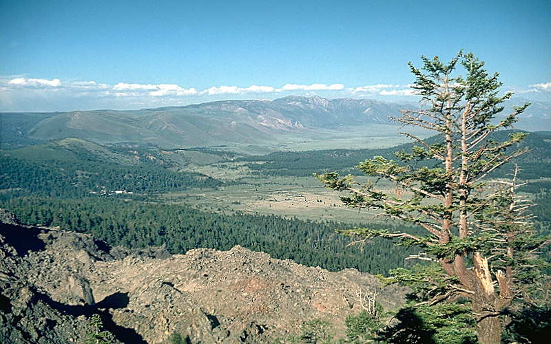
The Long Valley Caldera is a broad volcanic depression in eastern California adjacent to Mammoth Mountain. At roughly 20 miles long by 11 miles wide and up to about 3,000 feet deep, it ranks among the planet's larger collapsed volcanic structures and is often described as one of Earth's largest calderas. Today the caldera is a landscape of meadows, forested slopes and thermal features that attract scientists and visitors alike.
Image gallery
8 Images


Physical characteristics
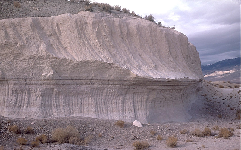
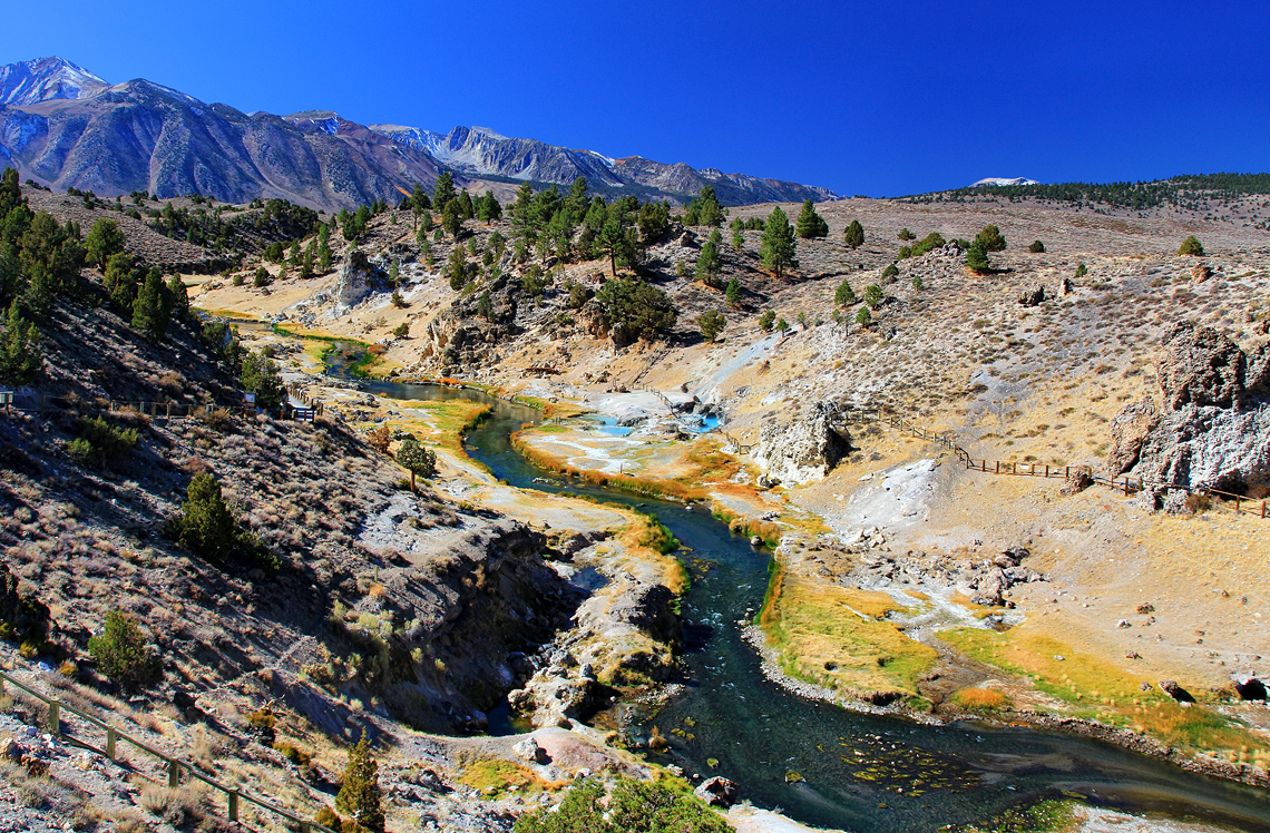
The caldera floor and its surroundings preserve distinct volcanic landforms and deposits. A prominent resurgent dome occupies part of the interior, and hot springs, fumaroles and hydrothermal alteration are scattered across the area. The region contains thick welded ash deposits called the Bishop Tuff, which record the explosive origin of the basin. Beneath the surface lies a partially cooled and complex magmatic system; when active, such a system is commonly called a magma chamber.
- Size: about 20 by 11 miles and up to ~3,000 ft deep.
- Major deposits: Bishop Tuff, welded tuff sheets and pumice.
- Thermal features: fumaroles, gas vents and hot springs.
- Nearby landmarks: Mammoth Mountain ski area and high-elevation recreation.
Origin and eruptive history
Long Valley formed when a very large eruption roughly 760,000 years ago expelled enormous volumes of hot ash and pumice. That explosive event produced energetic pyroclastic flows and widespread ashfall that blanketed much of the western part of the present-day United States. The eruption phase that created the caldera removed hundreds of cubic kilometres of magma — estimates commonly cited for the erupted material are on the order of 600 cubic kilometres — and the emptying of the magma body led the roof of the chamber to collapse, producing the depression visible today. By comparison, the 1980 Mount St. Helens eruption expelled only a small fraction of that volume.
Modern activity, hazards and monitoring
The Long Valley region remains geothermally and seismically active. Scientists have recorded episodes of earthquake swarms and ground uplift, signs interpreted as movement of fluids or magma at depth. Gas emissions, particularly carbon dioxide, can collect in low-lying areas and present localized hazards; a tragic example occurred in 2006 when three ski patrollers on Mammoth Mountain died after falling into a gas-filled vent while attempting to fence it off — the victims suffocated from carbon dioxide released from a near-surface fumarole. Because of the combination of unusual geothermal behavior and the potential for ash-producing eruptions — though a repeat of the initial supereruption is not considered likely in the near term — the caldera is closely monitored by geological agencies.
Uses and significance
Long Valley is significant scientifically as a natural laboratory for studying large explosive eruptions, caldera collapse, and post-eruption hydrothermal systems. The area offers resources and opportunities for geothermal energy research, outdoor recreation including hiking and skiing, and educational field studies. Understanding its past activity helps inform hazard planning and public safety for nearby communities and infrastructure.
Notable distinctions
Long Valley's combination of a very large eruption volume, extensive welded tuff deposits (the Bishop Tuff), ongoing geothermal expression and proximity to populated and recreational areas makes it notable among volcanic systems in the United States. It is often compared in public discussion to other large calderas and to smaller, better-known explosive eruptions as a way to convey scale and potential consequences. For further regional and scientific information see resources linked here: regional overview, caldera comparisons, supervolcanic terminology, Bishop Tuff details, magma chamber concepts, pyroclastic processes, western U.S. ashfall, national context, eruption comparisons, gas hazard guidance, and fumarole risks.


Questions and answers
Q: What is Long Valley Caldera?
A: Long Valley Caldera is a depression in east California next to Mammoth Mountain, which is one of the Earth's largest calderas resulting from a gigantic volcanic explosion.
Q: When did Long Valley Caldera form?
A: Long Valley Caldera formed 760,000 years ago as a result of a supervolcanic eruption.
Q: How big is Long Valley Caldera?
A: Long Valley Caldera is about 20 miles (32 km) long (east-west), 11 miles (18 km) wide (north-south), and up to 3,000 feet (910 m) deep.
Q: What is Bishop tuff?
A: Bishop tuff is a type of rock formation that is common to the Long Valley Caldera area. It was formed from very hot ash released during the supervolcanic eruption.
Q: Is Long Valley Caldera expected to explode again?
A: No, Long Valley Caldera is not expected to explode again in such a manner.
Q: How much material was released during the Long Valley Caldera eruption?
A: The Long Valley Caldera eruption released 600 cubic kilometres (140 cu mi) of material from vents inside the margin of the caldera, which is a significantly larger amount compared to the 1980 Mount St. Helens eruption.
Q: What happened to three members of the Mammoth Mountain Ski Area ski patrol in April 2006?
A: Three members of the Mammoth Mountain Ski Area ski patrol died from suffocation by carbon dioxide when they fell into a fumarole on the slopes of the mountain while attempting to fence it off.
Related articles
Author
AlegsaOnline.com Long Valley Caldera (Eastern California) Leandro Alegsa
URL: https://en.alegsaonline.com/art/59109
Sources
- articles.latimes.com : "3 Die in Mammoth Ski Patrol Accident"