Littoral zone: shoreward habitats and ecological role
The littoral zone is the nearshore area of seas, lakes and rivers where land and water meet; it includes intertidal areas, supports diverse communities, and plays key ecological and socioeconomic roles.
Overview
The littoral zone is the part of a body of water that lies close to the shore and where terrestrial and aquatic processes interact. It commonly describes the band from the uppermost shore that is rarely submerged down through areas that are permanently underwater but still influenced by nearshore conditions. The term applies to a sea, a lake or a river and is used in disciplines ranging from field ecology to oceanography and marine biology.
Image gallery
9 Images


Zones and key characteristics
Scientists commonly separate the littoral into subzones that reflect exposure to air, light and wave action. These include the supralittoral (splash or upper shore), the intertidal (regularly exposed and flooded), and the sublittoral (always submerged close to shore). In shallow freshwater systems the littoral is often defined by the depth to which enough light penetrates to support rooted aquatic plants.
- Supralittoral: above typical high water, influenced by spray.
- Intertidal (littoral in common use): alternately exposed and submerged; a zone of strong environmental gradients and zonation.
- Sublittoral/nearshore: permanently submerged but ecologically distinct from open water; may extend to a continental shelf edge in ocean contexts (continental shelf).
Biological communities and functions
Littoral habitats support a wide range of organisms: algae and seagrasses, mangroves and saltmarsh plants, invertebrates such as barnacles and worms, fish nurseries and shorebird foraging areas. Structural plants and sediments stabilize the shoreline, trap nutrients, and provide shelter and feeding grounds for juvenile fish and invertebrates. Because light and nutrients are generally abundant near shore, primary productivity and decomposition rates tend to be high.
Human uses and ecological importance
People rely on littoral zones for fisheries, recreation, transport, and coastal protection. Wetlands and marshes in the littoral buffer waves, reduce erosion and filter pollutants. In islands and estuaries the littoral is crucial for local economies and biodiversity. Management and planning often focus on these nearshore areas because they concentrate ecological value and human pressure alike (coastal environments).
Threats, study and conservation
Littoral zones face habitat loss from shoreline development, pollution, dredging, invasive species and rising sea levels. Scientists study them using transects, quadrats, long-term monitoring and aerial or satellite methods. Conservation actions include establishing buffer zones, restoring vegetation, restricting damaging activities and protecting key nursery and wetland areas. Effective strategies often require integrating freshwater, estuarine and marine perspectives because processes and impacts cross boundaries (intertidal zone).
Distinctions and notable facts
Though often used interchangeably with the intertidal, "littoral" can be broader, encompassing permanently submerged nearshore habitats as well as tidal flats. In rivers the littoral concept overlaps with riparian and shallow vegetated areas. For further context see resources on shore dynamics and nearshore ecology: shore studies and comparative summaries at specialised portals (sea, lake, river).
Readers seeking introductory or technical material can follow general references on marine and freshwater littoral systems (oceanography, marine biology) and reviews about the role of the continental shelf in defining nearshore boundaries.
Lakefront zoning
The majority of photosynthetic activity takes place in the sunlit littoral. The animals settled in this habitat form spatially delimited organizational groups. In the littoral of a lake, there are three plant zones: Reed zone, floating leaf zone, and diving leaf zone.
- Epilitoral, alder belt, willow scrub zone
Moisture-tolerant plants thrive on the lakeshore, hygrophytes such as mosses, rushes and marsh marigold. Alder swamp forests with willow, downy birch and black alder determine the picture among the plants of the higher floors.
- Supralittoral, splash zone
This strip of shore is not reached by the waves. However, it is soaked by the splash water of the waves breaking on the shore. A rinsing seam can form here.
- Eulittoral, surf zone
Strong mechanical forces prevail in the surf zone, which do not allow larger plants to grow. However, firmly attached, oxygen-loving organisms such as strudel worms (Turbellaria spec. ) and crust-forming cyanobacteria can settle here.
- Infralittoral or sublittoral
This zone is home to larger plants that are adapted to a constantly flooded soil. They have an aerenchyma, an interconnected system of large intercellular spaces, so that the roots can also be supplied with oxygen. This riparian area serves as a spawning and breeding ground for many fish, amphibians, birds, and insects. The infralittoral is divided into different sections.
Below the shore zone, separated by the trophic compensation layer, lies the dark depth region, the profundal.
See also: Lake ecosystem


Zoning of the sea coast
The zoning designation of the littoral on a seashore depends on the water depth and the presence of tidal influence (tide, tidal).
- Epilitoral
In the vicinity of the coast, in the dune area behind beach walls and dikes, the influence of the sea can still be seen through rising saline groundwater and salt water dust in the air. At most, extreme storm surges reach this area.
- Supralittoral or Supratidal
The splash zone above the high tide line outside the tidal range, which is only briefly covered by water during storm surge events.
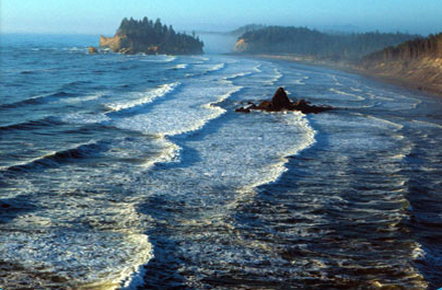
- Eulittoral, hydrolittoral, littoral or intertidal
The intertidal zone between the high and low tide lines, characterized by the alternation between low and high tide. Tide pools are found here with rocky substrates. Species-rich mangrove forests also form on tropical coasts.
- Sublittal or Subtidal
The shallow (neritic) shelf region permanently covered by water, below the low-water line to the shelf edge at an average depth of 200 m. Coral reefs also form near the shore, initially as fringing reefs, and on islands also coral atolls.
Related articles
Author
AlegsaOnline.com Littoral zone: shoreward habitats and ecological role Leandro Alegsa
URL: https://en.alegsaonline.com/art/58546