Armenia
![]()
This article is about the present-day Republic of Armenia. For other meanings, see Armenia (disambiguation).
Template:Infobox State/Maintenance/TRANSCRIPTION
Template:Infobox State/Maintenance/NAME-German
Armenia (Armenian Հայաստան Hajastan [hɑjɑsˈtɑn], officially Republic of Armenia, Armenian Հայաստանի Հանրապետություն Hajastani Hanrapetutjun [hɑjɑstɑˈni hɑnɾɑpɛtutʰˈjun]) is a landlocked country in the Near East and Caucasus with a population of about 3 million. It borders Georgia to the north, Azerbaijan to the east, the Azerbaijani exclave of Nakhichevan and Iran to the south, and Turkey to the west. The state territory includes the northeastern part of the formerly much larger Armenian settlement area, which, however, rarely formed a unified empire in the country's eventful history. Yerevan is Armenia's capital and largest city, with a population of around one million. Other important cities are Gyumri, Vanadzor and Vagharshapat with the cathedral of Echmiadzin (UNESCO World Heritage Site).
Statehood
In 188 BC, Artaxias I proclaimed himself king of Armenia. His descendants, the Artaxid dynasty, consolidated the continued independence of Greater Armenia as an independent kingdom. Around 95 to 55 BC, the power of the Artaxid state reached its peak under Tigranes the Great. A little later, however, the country became the plaything of the two great powers between which it lay, namely the Roman Empire and the Arsacid Parthian Empire. In the middle of the 1st century AD, the two powers agreed that henceforth only Arsacid princes would ascend to the Armenian throne with the consent of the Roman emperors. When the Sassanids took power in Iran in 226 AD, the Arsacids were able to hold their own in Armenia until 428.
The main milestones of national independence were the adoption of Christianity by King Trdat III. According to tradition and the official Armenian view, this took place in 301 AD, but according to historical research around 315 (i.e. only after Emperor Constantine), and in 405, when the Armenian script was introduced. In late antiquity, however, there were not only Christians in the country, but Zoroastrianism also had numerous followers. After the division of the Armenian kingdom of the Arsakids in 387 between Eastern Rome in the west and the Sassanid Empire in the east (Persarmenia), the Armenian settlement area was united only once more, from 885 to 1045, under the Bagratids, whose capital was Ani from 961.
Christian Byzantines and Muslim Arabs had been vying for control of the country since the 7th century. In 1064, the Seljuks conquered Armenia, followed by the Mongols in the 13th century. In 1555 the country was divided between Persia and the Ottoman Empire, and a second time in 1639, when the Safavids gained roughly the present territory of the country and the Turks the larger western portion. In the Russo-Persian War, Persia lost the province of Armenia to the Russian Empire in 1828. During World War I, many Armenians in the Ottoman Empire were systematically exterminated in the Armenian Genocide, and the Armenian settlement area greatly shrank. The border between Turkey and the Russian sphere of influence was established in 1922. The Armenian Soviet Socialist Republic, part of the Soviet Union, gained independence with the breakup of the Soviet Union in 1991. The territories west of it remained lost to Armenia.
Geography
Location and structure
Armenia is located in the region of the Near East at the junction between Asia Minor and (what is so named from a European perspective) Transcaucasia, between 38° 51′ and 41° 16′ north latitude and 43° 29′ and 46° 37′ east longitude. The state covers an area of 29,800 km² in the northeast of the Armenian Highlands and on the southern edge of the Lesser Caucasus.
At just under 30,000 km², Armenia's land area is roughly the size of the German state of Brandenburg. It borders Georgia to the north, Azerbaijan to the east, Iran to the southeast, the Azerbaijani exclave of Nakhichevan to the south and Turkey from the southwest to the west. The current population is about three million.
Armenia is a mountainous country. 90% of the country lies more than 1000 meters above sea level, the average altitude is even 1800 meters. From the north, the foothills of the Small Caucasus extend over 3000 meters high. The highest elevation is the extinct volcano Aragaz (4090 meters) not far from the biblical Ararat, the lowest point is about 380 meters high at the river Aras at the border to Iran and Azerbaijan. The area lies in a folded mountain range - it was formed and is still changing due to the collision of the Eurasian Plate with the Arabian Plate - and is accordingly highly prone to earthquakes. The rock is often of volcanic origin. Among the mineral resources that have been discovered, the most important are various copper oxides, which contain molybdenum, iron and gold as by-products, as well as uranium, various semimetals, gemstones and rock types such as tuff, basalt, marble and others. In addition, there are mineral water springs, the water of which is used for medicinal purposes and in everyday life.
The largest lake in Armenia and the entire Caucasus is Lake Sevan, which is located northeast of Yerevan at an altitude of about 1900 metres and currently covers an area of about 1242 km². Due to water extraction its area has decreased considerably (1984: 1262 km²). The longest rivers of Armenia are Aras, Vorotan, Kassagh, Hrasdan and Debed.
Climate
Through the territory of the Republic of Armenia runs the 40th parallel, which also passes through Menorca and the northern border region of California, and near which are cities such as Otranto, Aranjuez, Philadelphia and Beijing. However, the considerable differences in altitude - for example, only about 50 km south of Mount Aragaz (altitude 4090 m) runs the valley of the river Aras (at an altitude of about 840 m) - and the small-scale, varied landscape structure result in different local climates. On the one hand, the nearby seas have a balancing effect, on the other hand, the high mountains of the surrounding area favour extreme fluctuations. The high peaks of the Caucasus counteract strong cold spells from the north. In the valleys and lowlands, the climate is continental, with summer temperatures usually above 30 °C around midday. In the mountains it is altogether somewhat cooler, and on the border with Iran subtropical and very dry.
See also: Climate in the article Yerevan
plant and animal species
The territory of the Republic of Armenia is rich in species; there are many endemic species. Salt plants are found in the Aras lowland. Up to an altitude of 1400 meters, Artemisia are widespread. In the mountainous terrain, many thorny shrubs and other spiny plants, such as thistles, grow. In the high mountains, drought-loving plants occur more frequently. Around 1900, about 25 percent of the area was covered by trees or shrubs, in 1964 about 15 percent, and in 2005 only eight to 10 percent.
In Sangesur in the south of the country, the tree line is at 2400 meters. At even higher altitudes, the flora resembles that of the Alps.
The Latin name of the apricot, Prunus armeniaca, translates as "Armenian plum". The apricot is one of the symbols of Armenia.
There are many reptiles, including the Armenian rock lizard and poisonous snakes such as vipers, among the arachnids also scorpions. Wild boar, jackals, roe deer, mink, gulls and eagles live in wet lowlands; in the steppes in the mountains mainly rodents; in the forests also Syrian brown bears, wild cats and wolves. In the Khosrov nature reserve still live lynxes, wild goats and some Caucasian leopards. Armenian wild sheep also occur near this reserve and in the southern Sangesur Mountains. Their total population in Armenia is estimated at only about 250 animals. However, the subspecies of the mouflon is also found in neighbouring countries such as Iran.
Invertebrates are poorly studied in Armenia. For example, of the very species-rich web spiders, only about 150 species have been recorded so far.
Protected areas
Armenia has several reserves and national parks. These include the Khosrov Reserve located southeast of the capital, the arid Erebuni National Park in close proximity to Yerevan, the forested Shikahogh Reserve in the south of the country, the Sevan and Dilijan National Parks, the Arevik National Park, the Arpi National Park and the Zangezur Reserve.
Armenia has also nominated 23 emerald sites with a total area of 10,337.20 km² (34.69% of the national territory) (as of December 2020), pending recognition by the Committee of the Council of Europe as protected areas under the Bern Convention.
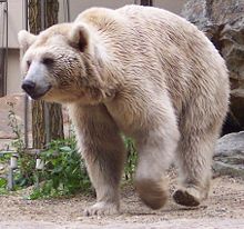
Syrian brown bear
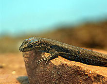
Armenian rock lizard
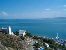
View over Lake Sevan
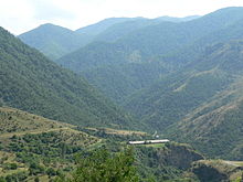
Landscape in Lori

Tatev Monastery in Zyunik
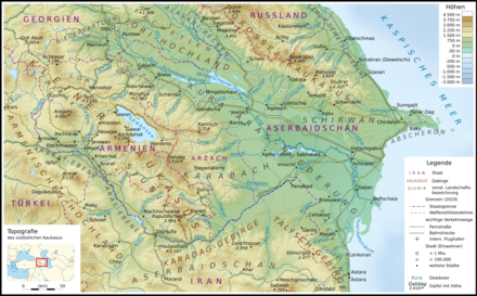
Topography of Armenia and neighboring Azerbaijan
Questions and Answers
Q: Where is Armenia located?
A: Armenia is located in the Armenian Highlands of Western Asia.
Q: What is the official name of Armenia?
A: The official name of Armenia is the Republic of Armenia.
Q: What language do Armenians speak?
A: Armenians speak Armenian.
Q: Is Armenia a coastal country?
A: No, Armenia is a landlocked country.
Q: How would you say "Armenia" in Armenian?
A: "Armenia" would be said as "Հայաստան" in Armenian.
Q: What continent does Armenia belong to?
A: Armenia belongs to the continent of Asia.
Search within the encyclopedia