Landshut — city in Lower Bavaria, Germany
Landshut is a historic Bavarian city on the Isar River, known for medieval architecture, the Trausnitz Castle, the St. Martin church tower and the traditional Landshut Wedding festival.
Overview
Landshut is a city in Lower Bavaria in southern Germany. It lies on the banks of the Isar River and serves as a regional centre of administration, commerce and culture. The town blends a well-preserved medieval core with modern industries and educational institutions.
Image gallery
10 Images


Geography and municipal structure
Situated between larger urban areas, Landshut has a compact historic centre framed by older fortifications and later suburbs. The Isar River has shaped the town's layout and waterways. Today the municipality includes residential neighbourhoods, commercial zones and green belt areas that connect to the surrounding Bavarian countryside.
History and development
Landshut's origins date back to the Middle Ages when it grew as a ducal seat of the Wittelsbach family. Its medieval prosperity is visible in civic buildings and the urban plan that survived war and modernization. Over centuries the town developed crafts, trade and later light industry while retaining many historic monuments.
Landmarks and cultural life
- Trausnitz Castle — a medieval fortress and former ducal residence overlooking the town.
- St. Martin's Church — noted for its towering brick Gothic spire and Gothic interior elements.
- Old Town — narrow streets, market squares and preserved façades that reflect Landshut's medieval character.
Every generation in Landshut has celebrated local traditions; the best-known is the historic Landshut Wedding, a large pageant that commemorates a 15th-century ducal marriage with costumes and parades.
Economy, education and significance
The town combines small and medium enterprises with branches of technology, manufacturing and supplier firms tied to the broader Bavarian economy. Landshut also hosts higher education and applied-research institutions that support regional skills and innovation. As a regional hub it attracts tourism for its festivals and historic sites while serving as a centre for local services and government.
Notable facts and distinctions
Landshut is often noted for the striking contrast between its well-preserved medieval core and contemporary industrial districts. Its architectural heritage, cultural events and riverside setting make it a distinctive example of a Bavarian town where history and modern life coexist.


Geography
Geographical position
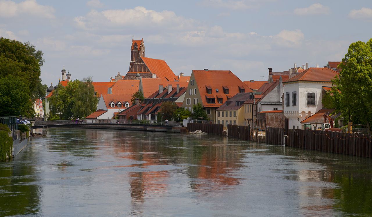
Landshut is located in the centre of the Lower Bavarian Hill Country (more generally also "Tertiary Hill Country"), which extends from the Danube in the north to the border of the Munich Gravel Plain in the south; the city thus belongs to the Alpine foothills. The tertiary hill country is interrupted in the urban area of Landshut by the riverbed of the Isar. Most of the built-up area lies on the flat terrace deposits of the river in the Isar valley. The Isar divides Landshut into three major urban areas: a northern part in the Isar-Danube hill country, a southern part in the Isar-Inn hill country, and the Mühleninsel in the city center. The southern districts of the city are bordered by a chain of hills, some of which rise steeply. The Hofberg, 505 metres above sea level, is the highest point in the urban area. Southwest of the built-up area in the direction of Moosburg is the bird sanctuary Mittlere Isarstauseen, which is one of the most valuable water bird sanctuaries in Bavaria. Further man-made lakes are located on the lower Isar to the east of the city area, the most important of which are the Altheim reservoir, the Niederaichbach reservoir and the Gretlmühle bathing lakes. To the north of the Isar, the Landshut flood basin runs through the city. As the name suggests, it is flooded in the event of a flood and thus relieves the actual course of the river in dangerous situations. In its unflooded state, the Flutmulde is one of Landshut's most popular parks.
The city is located about 70 km south of Regensburg and Straubing, 75 km southwest of Deggendorf, 120 km west of Passau, 60 km northwest of Altötting as well as 100 km from Traunstein, 85 km north of Rosenheim and 70 km northeast of the state capital Munich.
Geology
There are extensive bentonite deposits near Landshut, which are also mined. The formation of the bentonite is directly related to the Ries event.
Climate
The city of Landshut is located in the temperate climate zone with continental character. The climate is humid all year round. The average annual temperature is 8.5 °C, with January being the coldest month of the year with an average temperature of -1.0 °C and July being the warmest month of the year with an average temperature of 18.1 °C.
The average annual precipitation of 824 mm is among the upper average compared to other Bavarian cities. The precipitation of southern Bavaria basically increases from the north towards the Alps; thus, the average annual precipitation in Regensburg, located north of Landshut, is only 637 mm, while Rosenheim, located near the Alps, records 1075 mm of precipitation per year. The month with the most rain is July, when over 100 mm of precipitation falls, while February is the month with the least precipitation, with only 43 mm. Most snow falls in the days grouped around January 8.
City area
The city of Landshut is an enclave within the district of the same name. The urban area covers a total area of 65.7 square kilometres, which by and large follows the course of the Isar river flowing from the southwest to the northeast. This is how the relatively generous east-west expansion, which is a maximum of 21.5 kilometres, comes about. In north-south direction the city area stretches at the widest point at most 7.2 kilometers.
While the built-up area of about 20.3% is located in the center of the area, the city is dominated by water and forest areas to the east and west, which together represent another approximately 20% of land use. The most distinctive form of land use is agriculture. Over 45% of the total land area of the county seat is used for agricultural purposes. Approximately 8.1% of the total land area is devoted to a wide variety of transportation uses. Only about one percent of the area serves as recreational land.
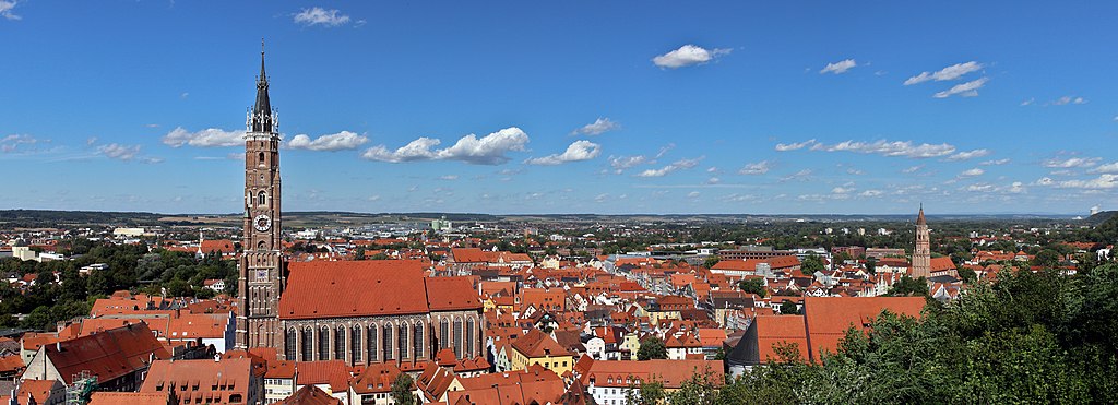
enlarge and show information about the picture
![]()
Panorama of Landshut (rare view of Trausnitz Castle and St. Martin's Basilica)
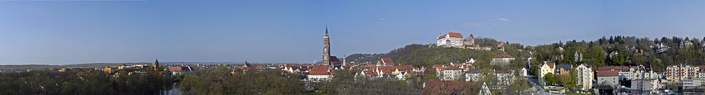
enlarge and show information about the picture
![]()
Panorama of the city Landshut from the castle Trausnitz in north direction
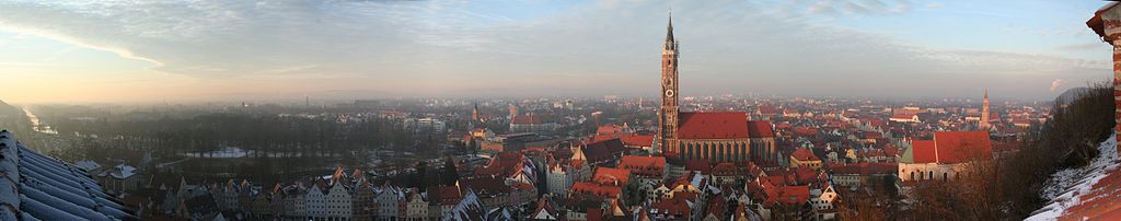
enlarge and show information about the picture
![]()
Panorama of the city Landshut from the castle Trausnitz in northeast direction
Neighboring communities
A total of nine municipalities border the area of the independent city of Landshut, all of which are located within the district of the same name. Starting clockwise, the municipality of Essenbach borders the city area in the northeast, followed by Niederaichbach in the far east, then the municipality of Adlkofen, followed by Kumhausen and Tiefenbach in the south. Finally, in the extreme southwest of the urban area, there are borders with Eching as well as Bruckberg. In the north, the municipalities of Altdorf and Ergolding still border.


City breakdown
Districts
There are eleven city districts. If a district is not represented on the city council, the citizens in their area are allowed to call a local assembly, as happened in Münchnerau, and elect a local speaker; the districts are not administered individually.
The eleven districts with information on area and population
| No. | District | Area in ha | Population1 | Inhabitants per | Comments |
| 00 | Old Town | 100 | 4672 | 4670 | historic town center |
| 01 | Nikola | 139 | 11284 | 8120 | between old town and main station |
| 02 | West | 533 | 11144 | 2090 | north of the Isar |
| 03 | Wolfgang | 340 | 10674 | 3140 | north of the main station |
| 04 | Industrial area | 311 | 3911 | 1260 | |
| 05 | Peter and Paul | 308 | 9074 | 2950 | |
| 06 | Schönbrunn | 898 | 4414 | 490 | Incorporation on 1 July 1972 |
| 07 | Frauenberg | 1582 | 3082 | 190 | Incorporation on 1 July 1974 |
| 08 | Mountain | 530 | 4888 | 920 | Incorporation on 1 April 1928 |
| 09 | Achdorf | 459 | 7294 | 1590 | Incorporation on 1 April 1928 |
| 10 | Münchnerau | 1381 | 1954 | 140 | Incorporation on 1 January 1972 |
| Landshut | 6581 | 72391 | 1100 |
1 As at: 31 December 2018
2 of which 2586 in the district of Auloh
Unofficial districts are for example Auloh (district Frauenberg), Mitterwöhr on the Isar island of the same name (district Peter and Paul), Schweinbach (district Schönbrunn) and Zwischen den Brücken on the Mühleninsel (district Altstadt).
Community parts
Independently of the above listing, there are 54 officially named municipal districts distributed over the entire district-free city, to which parts of the actual city (distributed over the districts 00 to 05), individual villages as well as hamlets and wastelands are counted. Until 1962 there were 57 community parts in the areas that today belong to Landshut.
| The districts of Landshut | ||||||
| No. | Community part | Type | Population1987 | formerCommunity | District | Comments |
| 001 | Landshut | Main site | 41183 | Landshut | 00 to 05 |
|
| 002 | Achdorf | District | 5866 | Achdorf | 09 Achdorf |
|
| 003 | Aign | Wasteland | 5 | Achdorf | 09 Achdorf |
|
| 004 | Attenkofen | Wasteland | 7 | Schönbrunn | 06 Schönbrunn |
|
| 005 | Aubach | Wasteland | 0 | Frauenberg | 07 Frauenberg |
|
| 006 | Auloh | Village | 1355 | Frauenberg | 07 Frauenberg |
|
| 007 | Aumühle | Hamlet |
| Wolfsbach | 07 Frauenberg | at 054 |
| 008 | Bartreith | Wasteland | 5 | Hohenegglkofen | 08 Mountain above Landshut |
|
| 009 | mountain above Landshut | District | 4047 | mountain above Landshut | 08 Mountain above Landshut |
|
| 010 | Berggrub | Wasteland | 9 | Hohenegglkofen | 08 Mountain above Landshut |
|
| 011 | Buchenthal | Village | 33 | Münchnerau | 10 Münchnerau |
|
| 012 | Dirnau | Hamlet | 34 | Wolfsbach | 07 Frauenberg |
|
| 013 | Dunivang | Hamlet | 39 | Frauenberg | 07 Frauenberg |
|
| 014 | Echingerhof | Wasteland | 10 | Münchnerau | 10 Münchnerau |
|
| 015 | Ehrnstorf | Hamlet | 13 | Hohenegglkofen (Niederkam) | 08 Mountain above Landshut |
|
| 016 | Eisgrub | Wasteland | 2 | Wolfsbach | 07 Frauenberg |
|
| 017 | Ellermühle | Hamlet | 22 | Münchnerau | 10 Münchnerau |
|
| 018 | Englberg | Village | Hohenegglkofen (Niederkam) | 08 Berg ob Landshut | at 009 | |
| 019 | Entenau | Hamlet | 31 | Wolfsbach | 07 Frauenberg |
|
| 020 | Feichtmaier | Hamlet | 19 | Münchnerau | 10 Münchnerau |
|
| 021 | Frauenberg | Church Village | 83 | Frauenberg | 07 Frauenberg |
|
| 022 | Gretlmühle | Village | 48 | Frauenberg | 07 Frauenberg |
|
| 023 | Gündlkoferau | Village | 64 | Münchnerau | 10 Münchnerau |
|
| 024 | Haag | Wasteland | 5 | Schönbrunn | 06 Schönbrunn |
|
| 025 | Hagrain | Village | Hohenegglkofen | 08 Mountain above Landshut | at 001 | |
| 026 | Hascherkeller | Settlement | Ergolding | 04 Industrial area | at 001 | |
| 027 | Kranzed | Wasteland | 6 | Schönbrunn | 06 Schönbrunn |
|
| 028 | Extinguishing fire | Settlement | Altdorf | 03 Wolfgang | at 001 | |
| 029 | Lurzenhof | Village | Schönbrunn | 06 Schönbrunn | at 040 | |
| 030 | Moniberg | Village | Schönbrunn | 05 Peter and Paul | at 001 | |
| 031 | Mühlhof | Wasteland | 2 | Schönbrunn | 06 Schönbrunn |
|
| 032 | Münchnerau | Church Village | 796 | Münchnerau | 10 Münchnerau |
|
| 033 | New building | Hamlet | 19 | Münchnerau | 10 Münchnerau |
|
| 034 | Neudeck | Wasteland | 3 | Wolfsbach | 07 Frauenberg |
|
| 035 | Peterreuth | Hamlet | 21 | Münchnerau | 10 Münchnerau |
|
| 036 | Riding farm | Hamlet | 7 | Wolfsbach | 07 Frauenberg |
|
| 037 | Sallmannsberg | Hamlet | 14 | Hohenegglkofen | 08 Berg ob Landshut |
|
| 038 | Salt Village | Hamlet | 45 | Hohenegglkofen (Götzdorf) | 08 Berg ob Landshut |
|
| 039 | Schaumburg | Wasteland | 5 | Wolfsbach | 07 Frauenberg |
|
| 040 | Schönbrunn | District | 2079 | Schönbrunn | 06 Schönbrunn |
|
| 041 | Schopperhof | Wasteland | Hohenegglkofen | 08 Mountain above Landshut | at 037 | |
| 042 | Schwaig | Wasteland | 0 | Frauenberg | 07 Frauenberg | uninhabited |
| 043 | Swine Creek | Church Village | 265 | Schönbrunn | 06 Schönbrunn |
|
| 044 | Seethal | Wasteland | 7 | Schönbrunn | 06 Schönbrunn |
|
| 045 | Seven Lakes | Village | 101 | Münchnerau | 10 Münchnerau |
|
| 046 | Stallwang | Village | 51 | Frauenberg | 07 Frauenberg |
|
| 047 | Sterneck | Wasteland | 3 | Wolfsbach | 07 Frauenberg |
|
| 048 | Strasbourg | Wasteland | 5 | Frauenberg | 07 Frauenberg |
|
| 049 | Unterschönbach | Wasteland | 11 | Schönbrunn | 06 Schönbrunn |
|
| 050 | Voglheerd | Wasteland | Schönbrunn | 06 Schönbrunn | at 001 | |
| 051 | Waas | Wasteland | 2 | Münchnerau | 10 Münchnerau |
|
| 052 | Wampelmühle | Hamlet | 20 | Münchnerau | 10 Münchnerau |
|
| 053 | Wolfstein | Wasteland | 5 | Wolfsbach | 07 Frauenberg |
|
| 054 | Wolfsteinerau | Village | 99 | Wolfsbach | 07 Frauenberg |
|
| … | Klausenberg 1) | Hamlet |
| Achdorf | 09 Achdorf | to 002 |
| … | Metzenthal 1) | Hamlet |
| Achdorf | 09 Achdorf | to 002 |
| … | Trausnitz 1) | Mountain castle |
| mountain above Landshut | 08 Mountain above Landshut | at 009 |
1) Name for officially named part of the municipality was abolished in 1962.
Local government districts
The division of the city area into 13 parishes is based on the former parish affiliation:
| No. | GT | District | Area | Unification | Parts of the district in neighbouring municipalities | Comments |
| 6618 | 0 | Achdorf | 336 | 01.04.1928 |
|
|
| 6615 | 1 | Altdorf | 177 | 01.07.1974 | Altdorf (0) | Extinguishing fire settlement |
| 6619 | 0 | mountain above Landshut | 226 | 01.04.1928 |
|
|
| 6588 | 1 | Ergolding | 141 | 01.07.1974 | Ergolding (0) | Hamlet Hasherkeller |
| 6621 | 0 | Frauenberg | 848 | 01.07.1974 | Adlkofen (1) |
|
| 6646 | 1 | Goetzdorf | 84 | 01.01.1972 | Kumhausen (0) | hamlet of Salzdorf |
| 6647 | 1 | Hohenegglkofen | 137 | 01.01.1972 | Kumhausen (0) |
|
| 6617 | 0 | Landshut | 1386 | ---------- |
|
|
| 6616 | 0 | Münchnerau | 1551 | 01.01.1972 |
| 1 July 1972 Municipality of Liebenau |
| 6645 | 1 | Niederkam | 44 | 01.01.1972 | Kumhausen (0) | Englberg and Ehrnstorf |
| 6594 | 1 | Ohu | 63 | 01.01.1982 | Essenbach (0) | Municipality-free area Untere Au (partial incorporation on 1 July 1972) |
| 6620 | 0 | Schönbrunn | 854 | 01.07.1972 |
|
|
| 6605 | 0 | Wolfsbach | 732 | 01.07.1974 | Niederaichbach (1), Adlkofen (2) | Partial incorporation to Frauenberg on 1 July 1971 |
|
|
| Landshut | 6579 |
|
|
|
The district of Landshut is divided into the districts 00 to 05.
The municipalities Achdorf, Münchnerau and Schönbrunn correspond approximately to the city districts of the same name. The former municipality-free area Liebenau was annexed to the Münchnerau district. Ohu, which belongs to Landshut and corresponds to the former municipality-free area Untere Au, also belongs to the district Schönbrunn.
The municipalities or parts of municipalities belonging to Landshut Altdorf and Ergolding belong to the districts Wolfgang and industrial area respectively.
The districts Hohenegglkofen, Götzdorf and Niederkam and the Hofgarten, which belongs to the district Landshut, form the district Berg together with Berg ob Landshut.
The districts Frauenberg and Wolfsbach (part of the district) essentially form the district Frauenberg.


Related articles
Author
AlegsaOnline.com Landshut — city in Lower Bavaria, Germany Leandro Alegsa
URL: https://en.alegsaonline.com/art/55851
Sources
- destatis.de : "Alle politisch selbständigen Gemeinden mit ausgewählten Merkmalen am 31.12.2018 (4. Quartal)" · web.archive.org
- statistikdaten.bayern.de : "Fortschreibung des Bevölkerungsstandes"
- commons.wikimedia.org : Landshut