Landmass
![]()
This article is not sufficiently supported by evidence (e.g., anecdotal evidence). Information without sufficient evidence may be removed soon. Please help Wikipedia by researching the information and adding good evidence.
In the geosciences (especially geography), land area, land mass or mainland is largely defined as that part of the earth's surface that rises above sea level and is therefore not covered by the water of the oceans and seas even at high tide. Some land areas, called depression, lie below sea level. The fact that these land areas are not inundated by sea water is due to the fact that they are shielded from sea water either by natural ridges or by dike structures. Freshwater entering these areas is often pumped away to higher areas.
The land area of the earth is about 149.4 million km² - that is 29.3 % of the earth's surface - and is mainly divided into the continents: Eurasia (geographical-geological umbrella term for Europe and Asia), Africa, America (North America, Central America and South America), Antarctica and Australia.
In particular, the large contiguous land masses of the earth - the continents (in the classical geographic sense) - are referred to as mainland. However, these are somewhat smaller than the contiguous masses of continental crust (continents in the geological sense), which also include the shallow marginal seas - the shelf areas. The border regions between the mainland and the sea are called coasts (obsolete: shores), whereby land areas that do not lie directly on the coastline can also be included in a coastal region (compare, for example, the terms east coast and west coast of the USA). In contrast to this is the inland, a land area that is proportionally far away from the sea on all sides.
Smaller and scattered land areas within waters are called islands and are not counted as mainland or land mass in the previous sense (compare the term continental Europe). In the case of larger and smaller islands, the main island is often referred to as the mainland, and the offshore islands are often referred to as side islands.
Unlike water surfaces, land surfaces react very quickly and strongly to varying solar radiation because they have a lower specific heat than water. For this reason, the land cools down more quickly overnight than the sea and warms up more quickly during the day. These temperature differences, which are often considerable during the day, are the cause of many regional wind systems. The same applies to the annual variation in temperature over the course of the seasons. The larger the land mass, the more pronounced this effect becomes and is typical of a continental climate.

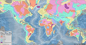
Geological breakdown of the Earth's crust: shades of grey indicate oceanic crust, all other colours indicate continental crust, which, however, also underlies marine areas to a lesser extent.
See also
- Terraferma (ital. for "mainland", Venice's landed property)
Norm data (subject term): GND: 4332546-4
Search within the encyclopedia