
Lambeth Bridge
Road and footbridge across the River Thames in central London connecting Lambeth and Westminster; known for its red paint, nearby landmarks and early 20th‑century replacement structure.
Overview
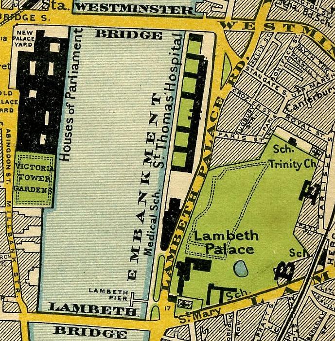
Lambeth Bridge is a vehicular and pedestrian crossing of the River Thames in central London. It carries east–west traffic between the London Borough of Lambeth on the south bank and the City of Westminster on the north bank. The river runs roughly north at the bridge, and nearby crossings include Westminster Bridge downstream and Vauxhall Bridge upstream. The bridge's approximate position is marked by the coordinates 51°29′40″N 0°07′23″W.
Image gallery
8 Images


Design and characteristics
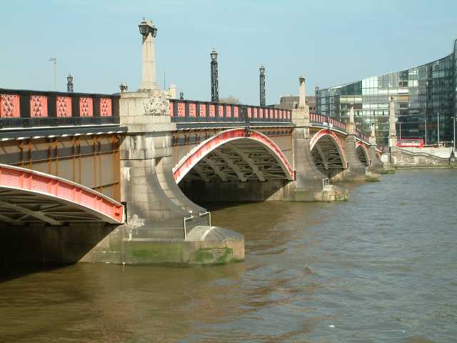
The present structure is a mid‑20th‑century steel crossing with masonry-faced piers and a carriageway flanked by footpaths. It is painted a distinctive red, a deliberate scheme that provides a visual counterpoint to the adjacent bridges and the nearby parliamentary precinct. The red paint is often noted by visitors because it contrasts with the green of Westminster Bridge, creating a memorable riverside palette. Lambeth Bridge supports ordinary road traffic, buses and pedestrians and offers clear sightlines to many central London landmarks.
History and development
A bridge has occupied this location since the 19th century when an earlier crossing was established to serve growing traffic and urban development on both banks. That first structure was later judged inadequate for the heavier motor traffic of the 20th century and was replaced by the current bridge, which dates from the early 1930s. The replacement preserved the crossing's alignment while introducing stronger materials and engineering suitable for increasing vehicle loads. The name derives from the historic parish and borough on the south bank.
Location and nearby landmarks
Lambeth Bridge sits close to several important sites. On the south (east) side is the riverside of the London Borough of Lambeth and the riverside entrance to Lambeth Palace, the London residence of the Archbishop of Canterbury. The north (west) bank is part of the City of Westminster and lies near Thames House, home to some national security offices. A short walk north and downstream leads to the Palace of Westminster and the Victoria Tower Gardens. The bridge is frequently used as a vantage point for views of these buildings and the river.
Transport role and public use
Lambeth Bridge is an active part of London's road network. It accommodates regular bus routes, private vehicles, bicycles and pedestrians, and it features in walking routes that trace the Thames. Because of its proximity to government and ecclesiastical buildings, the bridge can be subject to temporary closures or security measures during events and high-profile visits. Its location and alignment also make it a practical crossing for both local commuters and visitors exploring central London.
Notable facts and distinctions
Beyond its practical function, Lambeth Bridge is noted for its color scheme and riverside setting. Its red colouring is often mentioned in guides and photographs of the Thames. Navigationally, the bridge occupies a short reach where the river changes direction, and it forms part of a sequence of crossings that link the north and south riverbanks across the heart of the city. For further maps, photographs and technical details consult local resources and heritage listings via bridge records and Thames reference pages. Additional contextual material is available through central London and England overviews at central London and England.
- Nearby downstream bridge: Westminster Bridge
- Nearby upstream bridge: Vauxhall Bridge
- Local borough information: Lambeth
- Residence of the Archbishop: Lambeth Palace
- Government building close by: Thames House
For mapping, coordinates and navigational context see the marked coordinate link here and consult transport and heritage guidance via official bridge sources or riverside reference material at Thames resources. Additional reading and visitor information can be found through local and national portals at central London, England, and municipal pages for Lambeth and Westminster.
Questions and answers
Q: What are the coordinates of Lambeth Bridge?
A: The coordinates of Lambeth Bridge are 51°29′40″N 0°07′23″W / 51.49444°N 0.12306°W / 51.49444; -0.12306.
Q: On which side of the bridge is the London Borough of Lambeth located?
A: The London Borough of Lambeth is located on the east side of the bridge.
Q: Where is the official residence of the Archbishop of Canterbury located?
A: The official residence of the Archbishop of Canterbury is located in Lambeth Palace, which is situated on the east side of Lambeth Bridge.
Q: What can be found on the west side of Lambeth Bridge?
A: On the west side of Lambeth Bridge, one can find Thames House (the headquarters for MI5) and City Of Westminster.
Q: Where is Westminster Palace located relative to Victoria Tower Garden?
A: Westminster Palace can be found a short walk downstream from Victoria Tower Garden to its north direction.
Q: Which bridge lies downstream from Lambeth Bridge?
A: Westminster Bridge lies downstream from Lambeth Bridge.
Q: Which bridge lies upstream from Lambeth Bridge?
A: Vauxhall Bridge lies upstream from Lambeath Bridge
Related articles
Author
AlegsaOnline.com Lambeth Bridge Leandro Alegsa
URL: https://en.alegsaonline.com/art/55677
Sources
- www1.thamesdiamondjubileepageant.org : Key facts
- londontown.com : "Thames Jubilee Pageant,"
- telegraph.co.uk : "The Queen's Diamond Jubilee: Happy campers were cold, wet but unbowed,"