Lake Urmia: salt lake of northwest Iran, ecology, history, and recovery efforts
Endorheic salt lake in northwestern Iran between East and West Azerbaijan provinces; notable for high salinity, unique wildlife, dramatic shrinkage, and international conservation attention.
Overview
Lake Urmia (Persian name) is a large inland salt lake in northwestern Iran. Lying between the provinces of East Azerbaijan and West Azerbaijan, it occupies a basin with no natural outlet and has long been classified as an endorheic or closed salt lake. Its position in the landscape places it southwest of the Caspian Sea and near major urban centers such as Tabriz to the east and the city of Urmia to the west. The lake has been an important regional landmark, a cultural reference point, and an ecological resource for surrounding communities.
Image gallery
8 Images


Physical characteristics
Lake Urmia sits at roughly 37°42′N, 45°19′E and historically covered several thousand square kilometres at high stand. It is shallow compared with many inland lakes, with maximum depths typically measured in tens of metres; salinity varies seasonally and can become extremely high in low-water periods. The lake receives inflow from multiple rivers and mountain streams but lacks an outflow, so salts concentrate as water evaporates. These conditions have produced notable salt flats and a strongly saline water chemistry that shapes lake biology and colour.
Ecology and economic uses
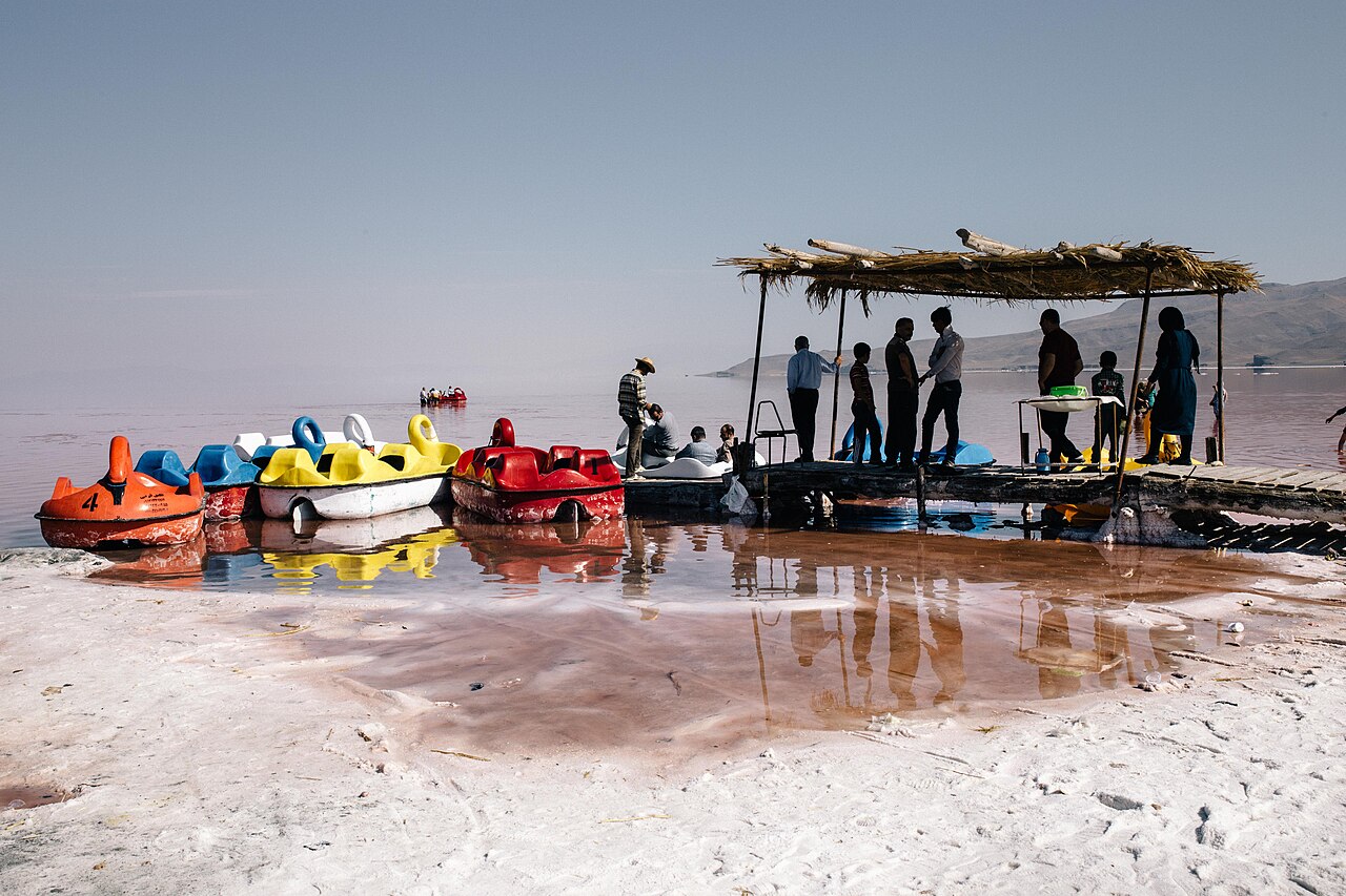
The lake supports a specialized assemblage of salt-tolerant organisms including halophilic algae and the endemic brine shrimp (Artemia) that feed migratory and resident birds. Large flocks of flamingos and other waterbirds have been recorded using the lake and its shores as feeding and staging areas. Locally, the lake has supported small-scale salt extraction and seasonal tourism. Its dramatic colours and birdlife have made it a site of scientific study and recreational interest.
History and human impacts
Human activity around Lake Urmia has shaped its recent trajectory. Agricultural expansion, increased irrigation withdrawals from inflowing rivers, construction of roads and causeways across the basin, and extended dry spells have reduced inflows and altered exchange between basins. Infrastructure projects proposed or built near and across the lake have been controversial because they can change circulation patterns. Proposals and works on crossings and causeways have been discussed and implemented at various times, affecting water movement and ecology.
Decline, threats, and restoration efforts
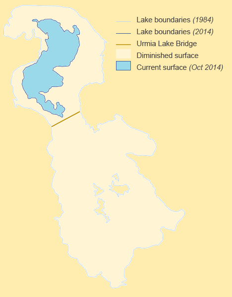
Beginning in the late 20th century and accelerating some decades later, the lake experienced substantial shrinkage. Main drivers include reduced river flow due to upstream water diversion for agriculture, prolonged drought, climate variability, and the impact of engineered crossings. Loss of surface area exposed salt flats that can produce airborne dust with implications for local air quality and agriculture. Governments, local communities and international observers have called for and implemented measures to restore the lake, including improved water management in the watershed, targeted releases to raise water levels, wetland protection, and modifications to infrastructure to improve hydraulic connectivity.
Distinctive facts and ongoing importance
- The lake is one of the largest salt lakes in the region and has been described in many sources as the largest lake in the Middle East at various times; it is an important regional geographic feature.
- Its saline ecosystem supports unique biota important to migratory bird populations; loss of the lake would have wide ecological consequences.
- Restoration and sustainable water use in the basin remain active policy and scientific priorities, with engineers, ecologists and communities working on monitoring, irrigation efficiency, and habitat rehabilitation.
For further context on geology, hydrology and conservation initiatives, readers can consult national and regional studies and resources provided by research institutions and environmental organisations. Additional background and updates on projects and policies related to the lake appear in many technical and public sources; examples include local government reports, scientific literature and conservation briefings (lake science, Iran context, location maps). Other relevant entry points include regional environmental programmes (regional resources), biodiversity surveys (ecological data), and news or policy summaries (policy, restoration, water management).
Scholars and policymakers frequently compare Lake Urmia to other saline and terminal lakes to understand patterns of hydrological change and social responses; this comparative approach helps frame long-term planning for sustainable water use and habitat conservation in semi-arid basins (regional case study, urban links). Continued monitoring and coordinated basin management are considered essential to preserve the lake's ecological functions and reduce health and economic risks to adjacent communities (local heritage, salt-lake ecology).
Questions and answers
Q: What is Lake Urmia?
A: Lake Urmia is a salt lake located in northwest Iran, between the provinces of East Azarbaijan and West Azarbaijan. It is the largest lake inside Iran and the second biggest salt lake in the world.
Q: Where is Lake Urmia located?
A: Lake Urmia is located at 37°42′0″N, 45°18′60″E.
Q: How big is Lake Urmia?
A: At its biggest extent, Lake Urmia has a surface area of about 5,200 km² (2,000 mile²) and it measures 140 km (87 miles) long and 55 km (34 miles) wide with a deepest point of approximately 16 m (52 ft).
Q: What cities are near Lake Urmia?
A: The closest cities to Lake Urmia are Tabriz to its east and Urmia to its west. The shortest way between these two cities is to go round the lake.
Q: Was there ever an attempt to build a bridge across the lake?
A: Yes, in 1970s there was an attempt to create a bridge across the lake but this project was canceled when Islamic Revolution happened in 1979. However, it was started again in 2000s and it's planned to be finished by the end of 2007.
Q: What is the concentration of salt in late Autumn?
A: In late Autumn, the concentration of salt in Lake Urmia can reach up to 26-28%.
Q: Why has Lake Urmia been getting smaller each year? A: The main reason why Lake Urmia has been getting smaller each year is because some of its rivers which bring water have become smaller over time.
Related articles
Author
AlegsaOnline.com Lake Urmia: salt lake of northwest Iran, ecology, history, and recovery efforts Leandro Alegsa
URL: https://en.alegsaonline.com/art/55578
Sources
- salinesystems.org : "Urmia Lake: A brief review"
- worldlakes.org : "Urmia Lake profile"
- britannica.com : "Lake Urmia"