Labrador Sea: geography, oceanography, ecology and human uses
Encyclopedic overview of the Labrador Sea: location, physical features, ocean circulation role, climate and sea ice, ecosystems, human use, navigation, research, and conservation.
Overview
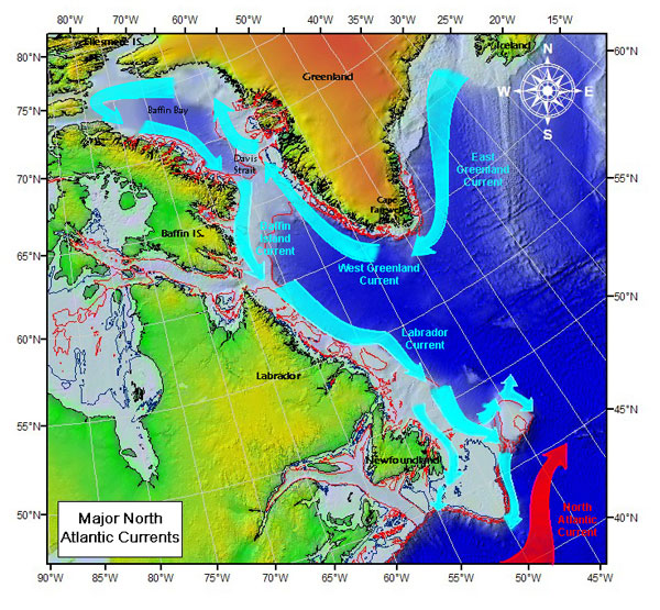
The Labrador Sea lies between the eastern coast of the Canadian mainland on the Labrador Peninsula and the western coast of Greenland. It is a northern arm of the North Atlantic Ocean, bounded in places by broad continental shelves and connecting northward to Baffin Bay through the Davis Strait. Oceanographers commonly treat the area as a marginal sea of the Atlantic. Despite its modest areal extent, the Labrador Sea is central to regional ocean circulation and climate.
Image gallery
5 Images


Physical characteristics
The basin reaches depths of roughly 3,400 metres at its deepest points and opens to the Atlantic over an expanse on the order of 1,000 kilometres. Bathymetry shallows toward the north as the sea transitions into Baffin Bay and the narrower Davis Strait. Surface waters are cold: winter temperatures approach the freezing point (near −1 °C), while summer surface values commonly reach about 5–6 °C. Salinity is lower than many parts of the North Atlantic, typically in the low 30s parts per thousand. Sea ice forms seasonally and historically covers a substantial fraction of the surface in winter.
Oceanography and circulation
The Labrador Sea is one of the principal sites of deep-water formation in the North Atlantic. Each winter, cooling of surface waters together with seasonal convection and mixing produces dense intermediate and deep water masses, often described collectively as Labrador Sea Water. These waters contribute to the larger-scale thermohaline circulation that redistributes heat and affects climate across the North Atlantic. Exchanges through the Davis Strait and along continental slopes drive currents, eddies, and cross-shelf transport of heat, salt, and nutrients.
Climate and sea ice
Regional climate over the Labrador Sea is strongly seasonal and influenced by interactions between ocean, ice, and atmosphere. Winter storms and cold air outbreaks promote sea-ice formation and deepen water column convection. In many winters a large fraction of the sea—historically as much as two-thirds—may be covered by ice or persistent pack ice. Interannual variability and longer-term warming trends have altered sea ice extent and the timing of melt, with consequences for ocean stratification and ecosystems.
Ecology and biodiversity
The Labrador Sea supports productive marine ecosystems adapted to cold, nutrient-rich waters. Phytoplankton blooms in spring and summer form the base of food webs that support zooplankton, small pelagic fish, larger groundfish, seabirds, and marine mammals including seals and several whale species. Offshore and shelf habitats host distinct communities; benthic assemblages on continental slopes and shelves are important for fisheries and biodiversity.
Fisheries, resource use and communities
Coastal communities in Labrador and Greenland have long depended on the sea for subsistence and commercial fishing. Historically important fisheries have included groundfish and pelagic species, though many stocks have experienced fluctuations due to overfishing, environmental change, and management measures. Interest in offshore resources, including hydrocarbon exploration in the broader region, has at times prompted scientific and regulatory attention, but exploitation is constrained by ice, remoteness, and environmental considerations.
Navigation, hazards and human impacts
Shipping in the Labrador Sea occurs seasonally and year-round in some corridors, with ice conditions and weather posing navigational hazards. Icebergs calved from Greenland and drifting sea ice represent specific risks to vessels. Human impacts include fishing pressure, shipping noise and emissions, and vulnerability to changing ice regimes. These factors, together with climate-driven changes, affect ecosystems and coastal livelihoods.
Scientific research and monitoring
The Labrador Sea has been the target of sustained oceanographic study because of its role in deep-water formation and climate. International research programs use ships, moorings, floats, and remote sensing to measure temperature, salinity, currents, sea ice, and biological productivity. Long-term observations help track variability in Labrador Sea Water properties and links to the wider Atlantic Meridional Overturning Circulation.
Conservation and management
Efforts to manage fisheries and protect habitats in and around the Labrador Sea involve national and regional authorities, often in consultation with Indigenous and local communities. Conservation measures, monitoring, and adaptive management aim to balance sustainable use with protection of biodiversity in a region experiencing rapid environmental change.
History and cultural context
Peoples of the North Atlantic and Arctic have used the coastal waters for millennia. European exploration, seasonal fishing, and later commercial activity shaped the modern maritime history of the region. The Labrador Sea remains a bridge between Arctic and North Atlantic environments and continues to be important for both local livelihoods and global climate science.
- Connections: northward to Baffin Bay and through the Davis Strait to the wider Atlantic.
- Classification: commonly described as a marginal sea of the North Atlantic Ocean.
- Boundaries: coasts of Labrador and Greenland, with extensive continental shelves along parts of its margin.
Questions and answers
Q: What is the Labrador Sea?
A: The Labrador Sea is an arm of the North Atlantic Ocean between the Labrador Peninsula and Greenland.
Q: What are the dimensions of the Labrador Sea?
A: The Labrador Sea is around 1,000 kilometers wide where it joins the Atlantic Ocean, and becomes shallower and 300 kilometers wide towards Baffin Bay.
Q: What is the depth of the Labrador Sea?
A: The Labrador Sea is around 3400 meters deep.
Q: What is the temperature range of the Labrador Sea?
A: The water temperature varies between −1°C (30°F) in winter and 5–6°C (41–43°F) in summer.
Q: What is the salinity of the Labrador Sea?
A: The salinity of the Labrador Sea is relatively low at 31-34.9 parts per thousand.
Q: What is the coverage of ice in the Labrador Sea during winter?
A: Two-thirds of the Labrador Sea is covered in ice in winter.
Q: How does the Labrador Sea connect to Baffin Bay?
A: The Labrador Sea connects to Baffin Bay through the Davis Strait.
Related articles
Author
AlegsaOnline.com Labrador Sea: geography, oceanography, ecology and human uses Leandro Alegsa
URL: https://en.alegsaonline.com/art/55238
Sources
- britannica.com : "Labrador Sea"
- books.google.com : Blackwell's concise encyclopedia of environmental management
- journals.ametsoc.org : Boundary Currents and Watermass Transformation in Marginal Seas
- books.google.com : "Non-volcanic rifting of continental margins: a comparison of evidence from land and sea"
- doi.org : 10.1144/GSL.SP.2001.187.01.05
- thecanadianencyclopedia.com : "Labrador Sea"
- books.google.com : Maritime services to support polar resource development
- books.google.com : Twentieth-century shore-station whaling in Newfoundland and Labrador
- elibrary.unm.edu : "The Labrador Duck – another specimen, with additional data respecting extant specimens"
- doi.org : 10.2307/1374306
- jstor.org : 1374306
- pubs.aina.ucalgary.ca : "Characteristics of the Wolf (Canis lupus lubrudorius Goldman) in Northern Quebec and Labrador"
- books.google.com : The Moravians in Labrador
- worldwildlife.org : Eastern Canadian Shield taiga (NA0606)
- fs.fed.us : Ledum groenlandicum Oeder – Labrador Tea