Kyoto: Historical and Cultural Capital of Japan
Kyoto is a major city in Japan known for its historic temples, traditional culture, and role as the nation's capital from 794 to 1868. It remains a center for education, tourism, and cultural preservation.

Kyoto (京都) is a prominent city in Japan that combines preserved tradition with modern life. For more than a millennium it served as the imperial capital, a role that began in 794 and lasted until 1868. Today Kyoto functions as the political and cultural heart of the historic Kansai area and retains an urban population while preserving large areas of historic architecture and gardens.
Image gallery
10 Images


Geography and population
Located in the Kansai region, the modern municipality is the administrative center of Kyoto Prefecture. Its urban population is often cited around 1–1.6 million residents (population figures vary with metropolitan boundaries), supported by a mix of residential neighborhoods, commercial districts, and protected cultural zones.
History and development
Established as Heian-kyō in the late eighth century, Kyoto grew around imperial institutions, Buddhist monasteries, and artisan quarters. The city became a focal point for court culture, poetry, tea ceremony, classical arts and religious scholarship. Although political power shifted to other cities in later centuries, Kyoto's role as a cultural repository deepened and many temples, shrines and traditional neighborhoods survived wars and modernization.
Culture, landmarks and tourism
Kyoto is noted for its concentration of historic sites: temples, Shinto shrines, imperial villas, moss gardens, and preserved merchant streets. Notable examples include:
- Kiyomizu-dera and other Buddhist temples
- Kinkaku-ji (the Golden Pavilion)
- Fushimi Inari-taisha with its torii gates
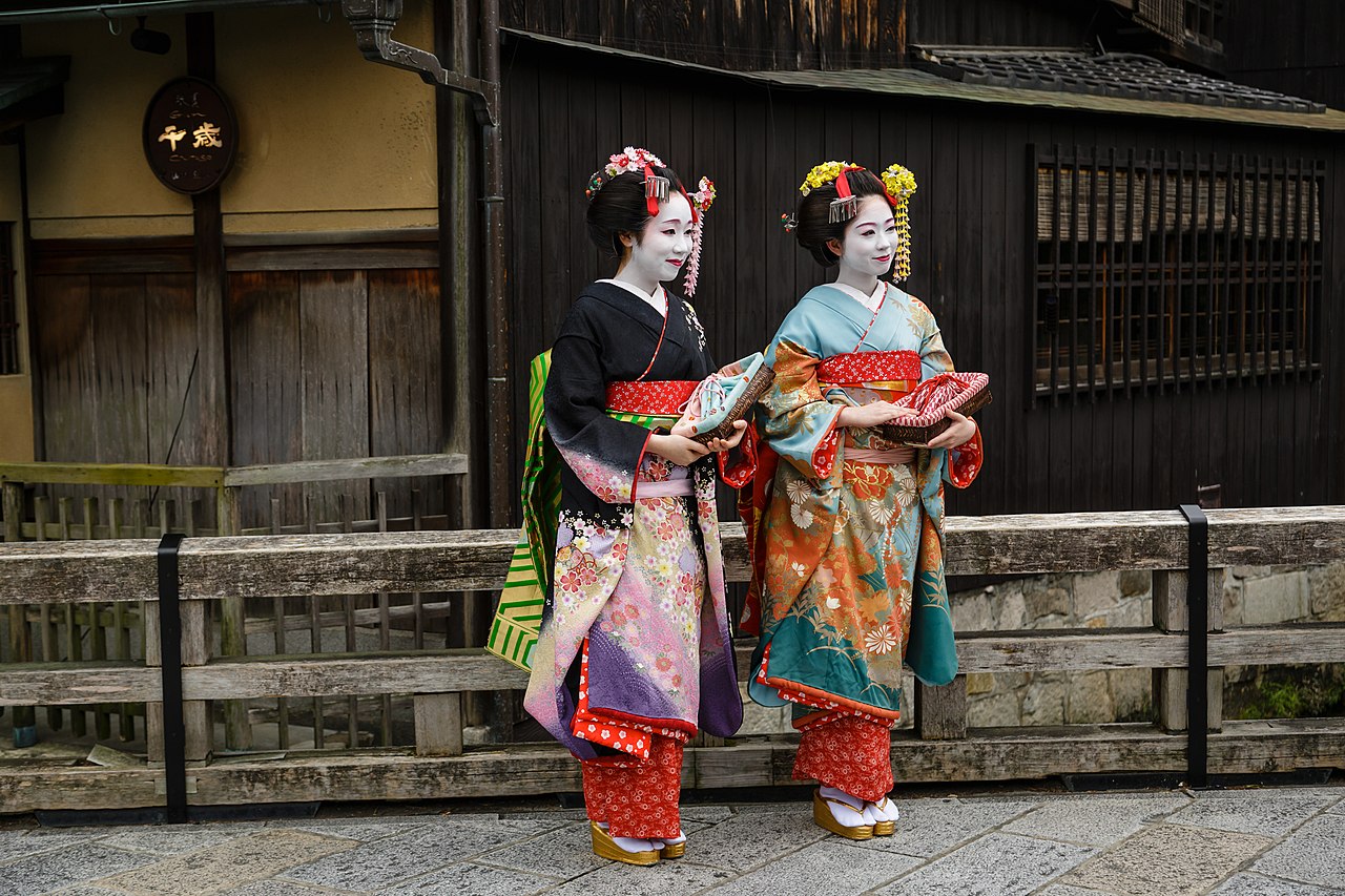
- The geisha districts such as Gion
These places draw domestic and international visitors who come to experience seasonal festivals, traditional crafts, and culinary specialties.
Education and economy
Kyoto is an educational hub with numerous institutions of higher learning, including Kyoto University, one of Japan's leading research universities. The city's economy blends tourism, higher education, conventional manufacturing, and technology sectors that coexist with long-standing artisan trades.

Visitors and residents alike find Kyoto notable for the continuity between past and present: historic neighborhoods and festivals remain active parts of daily life while the city adapts to contemporary needs. For practical information about travel, conservation efforts, and events consult local guides and official resources (historic overview, founding, restoration).
Geography
Kyōto is located about 400 km southwest of Tokyo in the mid-west of Japan's main island of Honshū, about ten kilometers southwest of Lake Biwa and about 40 km from Osaka. Its location in a basin open only to the south causes the sultry air to accumulate in summer; the northern part of the city becomes considerably colder in winter than the neighboring cities of Osaka and Kōbe. Unlike the latter, however, Kyōto is largely protected from typhoons by mountains rising to over 1,000 metres and is also hardly at risk of flooding.
The city is laid out like a chessboard according to classical Chinese geomancy. The center and the south are the economic heart of the city. Some of the tourist attractions are located in the center; however, most of the famous temples are located in the northeast and northwest of the city or on mountain slopes in the surrounding area.
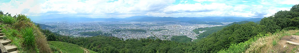
enlarge and show information about the picture
![]()
Panoramic view in west direction over the city center from Mount Daimonji-yama
City breakdown
Kyōto is divided into eleven municipal districts (-ku):
| the districts of the city of Kyōto | |||||||
| Code | Name | Area (in km²) | Population | Population density (Ew./km²) |
| ||
| Rōmaji | 1 January 2021 | 1 March 2021 | 01.10.20153 |
| |||
| 26101-7 | Kita-ku | 北区 | 94,88 | 116.442 | 119.474 | 1248,86 |
|
| 26102-5 | Kamigyō-ku | 上京区 | 7,03 | 83.350 | 85.113 | 12036,98 |
|
| 26103-3 | Sakyō-ku | 左京区 | 246,77 | 165.364 | 168.266 | 680,52 |
|
| 26104-1 | Nakagyō-ku | 中京区 | 7,41 | 110.009 | 109.341 | 14957,35 |
|
| 26105-0 | Higashiyama-ku | 東山区 | 7,48 | 36.105 | 39.044 | 5000,00 |
|
| 26106-8 | Shimogyō-ku | 下京区 | 6,78 | 81.905 | 82.668 | 12200,15 |
|
| 26107-6 | Minami-ku | 南区 | 15,81 | 101.507 | 99.927 | 6400,76 |
|
| 26108-4 | Ukyō-ku | 右京区 | 292,07 | 202.180 | 204.262 | 698,44 |
|
| 26109-2 | 伏見区 | 61,66 | 275.138 | 280.655 | 4512,89 |
| |
| 26110-6 | Yamashina-ku | 山科区 | 28,7 | 134.029 | 135.471 | 4681,74 |
|
| 26111-4 | Nishikyo-ku | 西京区 | 59,24 | 147.825 | 150.962 | 2517,99 |
|
| 26100-9 | Kyōto-shi | 京都市 | 827,83 | 1.453.854 | 1.475.183 | 1774,49 |
|
Population development of the city
| Year | Population | Gender ratio | Population density | Surface area | ||
| total | Male | female | ||||
| 1889 | 279.165 | —— | —— | —— | 9377,4 | 29,77 |
| 1899 | 358.573 | 180.756 | 177.817 | 101,7 | 12.044,8 | 29,77 |
| 1909 | 453.046 | 232.504 | 220.542 | 105,4 | 14.483,6 | 31,28 |
| 1920 | 591.323 | 299.686 | 291.637 | 102,8 | 9785,3 | 60,43 |
| 1925 | 679.963 | 350.759 | 329.204 | 106,6 | 11.252,1 | 60,43 |
| 1930 | 765.142 | 396.756 | 368.386 | 107,7 | 12.661,6 | 60,43 |
| 1935 | 1.080.593 | 555.792 | 524.801 | 105,9 | 3743,6 | 288,65 |
| 1940 | 1.089.726 | 545.107 | 544.619 | 100,1 | 3775,3 | 288,65 |
| 1947 | 999.660 | 483.028 | 516.632 | 93,5 | 3463,2 | 288,65 |
| 1950 | 1.101.854 | 533.426 | 568.428 | 93,8 | 2054,0 | 536,45 |
| 1955 | 1.204.084 | 585.963 | 618.121 | 94,8 | 2188,2 | 550,27 |
| 1960 | 1.284.818 | 628.250 | 656.568 | 95,7 | 2104,2 | 610,61 |
| 1965 | 1.365.007 | 670.157 | 694.850 | 96,5 | 2235,5 | 610,61 |
| 1970 | 1.419.165 | 697.418 | 721.747 | 96,6 | 2324,2 | 610,61 |
| 1975 | 1.461.059 | 718.213 | 742.846 | 96,7 | 2392,8 | 610,61 |
| 1980 | 1.473.065 | 721.402 | 751.663 | 96,0 | 2412,5 | 610,61 |
| 1985 | 1.479.218 | 721.281 | 757.937 | 95,2 | 2422,5 | 610,61 |
| 1990 | 1.461.103 | 708.601 | 752.502 | 94,2 | 2394,4 | 610,21 |
| 1995 | 1.463.822 | 706.859 | 756.963 | 93,4 | 2398,9 | 610,21 |
| 2000 | 1.467.785 | 704.281 | 763.504 | 92,2 | 2405,3 | 610,22 |
| 2005 | 1.474.811 | 703.210 | 771.601 | 91,1 | 1781,4 | 827,90 |
| 2010 | 1.474.015 | 701.088 | 772.927 | 90,7 | 1780,4 | 827,90 |
| 2015 | 1.475.183 | 699.748 | 775.435 | 90,2 | 1782,0 | 827,83 |
| 2018 | 1.468.980 | 695.829 | 773.151 | 90,0 | 1774,5 | 827,83 |
| 2019 | 1.465.448 | 694.130 | 771.318 | 90,0 | 1770,2 | 827,83 |
Source: Kyōto City Population Change PDF file 人口及び世帯数の推移(京都市).
- For the years 1889 to 1909 - status at the end of the year (population register)
- For the years 1920 to 2015 - status on census day (1 October).
- 2018 - Status as of 1 October - Population update
- 2019 - As of March 1, 2019 - Population update.

History
Under the name Heian-kyō, Kyōto became the second permanent capital of Japan in 794 under Emperor Kammu (781-806) after the abandonment of Heijō-kyō (Nara, 784) and a failed attempt at nearby Nagaoka-kyō (Nagaokakyō).
After the Dōkyō Incident, the influence of Buddhist monasteries was to be pushed back by banning them from the inner city area of about 4500 × 5200 meters in the new capital.
The Heian period, in which political power essentially emanated from Kyōto (though soon no longer from the emperor himself), lasted until 1185. Then, during the Muromachi period from 1333 to 1568, the Shōgunate, initially formed on the east coast, once again resided in Kyōto, but steadily lost power. With the devastation of the Ōnin War (1467-1477), the city began to decline, eventually consisting of only two separate areas on the eastern half of the city. It was not until the reign of Hideyoshi that reconstruction began in 1580. Only now temples were built within the city, which had been forbidden in the times before. In 1568, a first Christian place of worship was built, which was popularly called Namban-ji.
In the Edo period, beginning in 1603, the political center of Japan finally shifted away from Kyōto to the east coast. Courtly culture continued to be cultivated at the seat of the Tennō.
From the shogunate administration for the city of Kyōto and shogunate or imperial estates in the surrounding countryside, the (in the early years: city) Kyōto prefecture (-fu) was created in the Meiji Restoration, but it expanded to include extensive rural areas in several provinces when the prefectures were consolidated in the 1870s. In 1878/79 the prefectures were divided into counties (-gun) and urban counties/"districts" (-ku), with Kamigyō-ku and Shimogyō-ku established in the Kyōto urban area on April 10, 1879. These became the modern Kyōto County Free City (-shi) on April 1, 1889, as part of the reorganization of Japan's municipal system, and the -ku became boroughs. Until 1898, however, following an exemption of the empire's three largest cities from the city ordinance (shisei tokurei), the city of Kyōto remained without an independent administration and was governed directly by Kyōto's governor. Only then were independent mayors appointed. On April 1, 1929, the new districts of Higashiyama-ku, Nakagyō-ku, and Sakyō-ku were separated from both. On April 1, 1931, a number of surrounding towns were incorporated, creating Fushimi-ku and Ukyō-ku.
In World War II, Kyoto was originally high on the list of targets for the first use of the atomic bomb. In particular, General Leslie R. Groves called for Kyoto to be dropped because its location in a valley would have increased the impact of the blast. However, at the insistence of U.S. Secretary of War Henry L. Stimson, who had once visited the city and knew of its cultural significance, it was removed from the list. For the same reason, Kyoto was spared heavy air raids.
On September 1, 1951, Kita-ku was separated from Kamigyō-ku and Minami-ku from Shimogyō-ku. The last change in city division took place on October 1, 1976, when Nishikyō-ku was separated from Ukyō-ku and Yamashina-ku was separated from Higashiyama-ku.


Related articles
Author
AlegsaOnline.com Kyoto: Historical and Cultural Capital of Japan Leandro Alegsa
URL: https://en.alegsaonline.com/art/54779
Sources
- books.google.com : "Kyoto"
- books.google.com : "Heian-kyō"
- books.google.com : "Saikyō"