Krefeld: Industrial and cultural city on the Lower Rhine
Krefeld is a city in North Rhine-Westphalia, Germany, near Düsseldorf. With about 235,000 people, it is historically a textile centre and today notable for museums, modernist architecture and diversified industry.
Overview
Krefeld is a mid-sized city in Germany, located in the western part of the country within the state of North Rhine-Westphalia. It lies on the Lower Rhine, close to major urban centres such as Düsseldorf, and is part of the larger Rhine-Ruhr metropolitan region. The city has roughly 235,000 inhabitants and combines urban infrastructure with industrial and green areas.
Image gallery
10 Images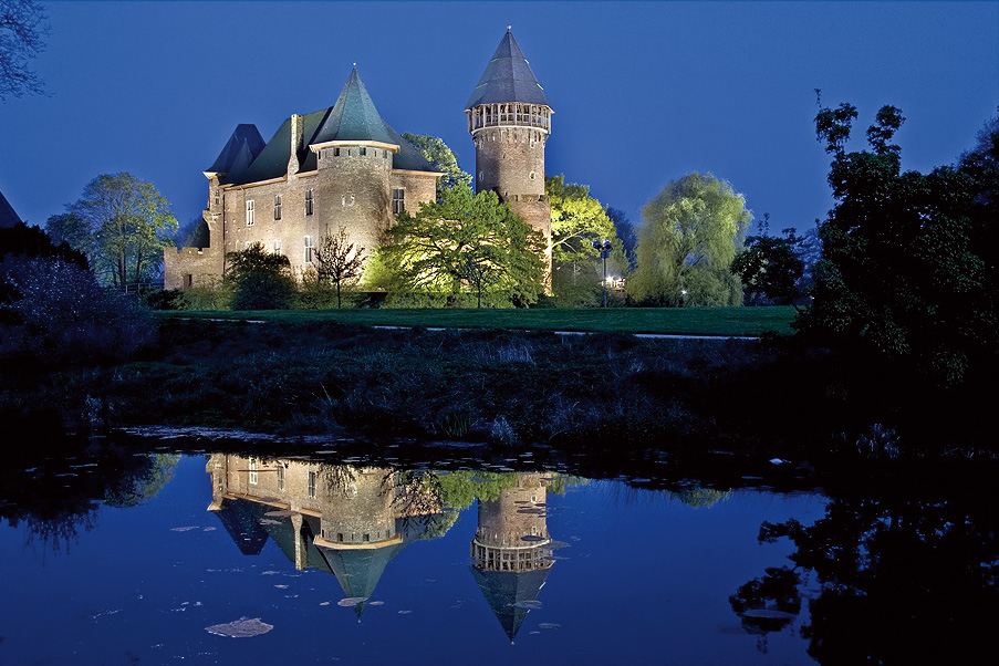


History and development
Known as Crefeld until 1925, Krefeld developed from a medieval market town into an industrial centre during the 19th century. Its growth was driven largely by textile manufacturing—especially silk and velvet—which shaped both the economy and the local built environment. Industrialisation brought transport links and a widening economic base that continued through the 20th century.
Characteristics and landmarks
Krefeld retains traces of its textile past alongside modern industry. Notable cultural landmarks include the two modernist villas designed by Ludwig Mies van der Rohe and several museums showcasing decorative arts and local history. Historic districts and riverfront areas reflect the city’s layered development from medieval to industrial eras.
Economy and institutions
While textiles were dominant historically, the contemporary economy is more diversified: chemical and electrical engineering firms, logistics, and service industries all play important roles. Cultural institutions, conservation projects and small-to-medium enterprises contribute to employment and urban life.
Culture, sport and transport
Krefeld has active cultural life, with museums, galleries and annual events that draw regional visitors. Sport is visible in local clubs, including professional and amateur teams. Good road and rail connections link the city to neighbouring centres; river access along the Rhine remains important for freight and recreation.
Notable facts and distinctions
- Formerly spelled Crefeld until the city name was reformed in the early 20th century.
- Renowned for its historic role in silk and velvet production, sometimes described as a textile city.
- Hosts examples of international modernist architecture and regional museums.
- Part of the densely populated Rhine-Ruhr area with close links to the Lower Rhine and neighbouring urban centres.
For further reading on regional geography, transport and cultural programmes, consult local municipal resources and regional guides. Krefeld’s mix of industrial heritage and modern urban life makes it a representative city of the Rhineland’s economic and cultural landscape.


Geography
Spatial position
Krefeld is located in the "Krefeld-Kempener Platte", which is part of the Lower Rhine Plain. The city centre is about seven kilometres from the banks of the Rhine, but since the incorporation of Linn, the city area extends right up to the Rhine. The length of the river bank on Krefeld territory is 6.2 kilometres. The width of the river varies between 320 and 400 metres. The largest extension of the city area is 12 kilometres in north-south direction and 13.1 kilometres in west-east direction. The altitude of the city center is 39 meters above sea level. The highest natural elevation is the Hülser Berg at 63 m above sea level. Artificial elevations are higher: The Inrather Berg is a rubble dump from the rubble of World War II with 87 m above sea level, the since 2004 freely accessible Kapuzinerberg has a height of 77 meters and is a former domestic waste dump.
Climate
Krefeld belongs macroclimatically to the Atlantic-Maritimeclimatic region of northwestern Germany, with mild, low-snow winters and moderately warm summers, in which the maximum annual precipitation is located. The long-term average of annual precipitation in Krefeld is 760 mm. The annual mean temperature in Krefeld is between 10.6 °C and 11.1 °C. The maxima of the air temperature are between 33.9 °C and 35.5 °C, the minima between -5.9 °C and -7.6 °C.
| Monthly average temperatures and precipitation for Krefeld
Source: DWD, data: 2015-2020 | ||||||||||||||||||||||||||||||||||||||||||||||||||||||||||||||||||||||||||||||||||||||||||||||||||||||||||||||||||||||||||||||||||||||||||||||||||||||||||||||||||||||||||||||||||||||||||||||||
Geology
The city of Krefeld is located in the Lower Rhine lowlands. The near-surface layers consist mainly of gravel and sand deposits of the glacial period. The layers, up to 30 m thick, were deposited by the Rhine. 240,000 years ago, these layers were partly pressed up by the edges of the ice sheet masses to form upsetting moraines, which today form the Lower Rhine heights. The Hülser Berg is an example of this. Beneath the gravel and sand layers are marine sands that were deposited there in the Tertiary period (2.4 to 65 million years before present). They extend down to a depth of 250 m. Underneath are marine deposits (consisting mainly of sandstone, mudstone and limestone) of older geological phases. On the northern edge of the city, coal-bearing strata from the Carboniferous period also occur at greater depths, which have connections to the coal regions in Belgium and on the Ruhr.
On the higher areas of the Krefeld city area, one finds predominantly Parabraunerden and Braunerden. These are good arable sites. The Kempener Platte, located in the western part of the city and somewhat raised by fracture tectonics, has a top layer of loess about 1 m thick. This was deposited here during the last ice age. The resulting fertile loamy soils are valued as grain and beet fields.
In the channels of the old branches of the Rhine (Kendeln), fen peat developed, which was also extracted at the Niepkuhlen, but is no longer of economic importance today. At the end of the last ice age, the Rhine deposited sandy to loamy sediments east of the terrace edge Dießem - Inrath - Hüls. Due to the influence of groundwater, gleye soils developed in the lower-lying areas. These areas are used as grassland and forest, like e.g. the Hülser and Latumer Bruch. In the flood-prone Rheinaue, fertile soils were also formed from alluvial soil material.
City area
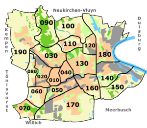
The city area of Krefeld is divided into 9 districts: Stadtmitte, West, North, Hüls, South, Fischeln, Oppum-Linn, East and Uerdingen. Each district has its own district council and a district head. The district representatives are elected by the population of the city district at every local election. Furthermore, there are 19 city districts, these are divided into several statistical districts.
The 19 districts with their official numbers are:
|
|
See also: List of districts of Krefeld and List of districts of Krefeld
Neighboring cities
The city of Krefeld borders the cities of Neukirchen-Vluyn and Moers in the district of Wesel to the north, the independent city of Duisburg to the east and northeast, the cities of Meerbusch in the Rhine district of Neuss and Willich in the district of Viersen to the south, and the cities of Tönisvorst and Kempen in the district of Viersen to the west.
To the southeast of Krefeld lies the state capital Düsseldorf, whose centre is about 19 km away from Krefeld's city centre.
Population
Demographics
→ Main article: Population development of Krefeld
In 1861, the city had more than 50,000 inhabitants. In 1888 it was over 100,000, making Krefeld a major city. By 1957, this number had doubled. In 1994, the population reached its historic high of around 250,000. At the end of 2018, 227,020 people lived in Krefeld. Of these, 116,275 (51.2%) were female.
In 2018, there were 2,033 births and 2,805 deaths in Krefeld, resulting in a negative birth balance of -3.3 per 1000 inhabitants. However, this was more than offset by positive net migration of +5.9 per 1000 inhabitants.
The population density in 2018 was 1698 inhabitants per km². The proportion of foreigners in the same year was 17.1%. 35.9 % of the population had a migration background. Of the approximately 84,000 employees subject to social insurance contributions, about 30% are employed in the manufacturing industry, only 0.5% in agriculture. 17.5 % of the people of Krefeld are under 18 years of age, 62.5 % are between 18 and 65 years of age and 20 % are over 65 years of age.
Religions
Confession statistics
As of 31 December 2018, the statistics of the city of Krefeld showed 89,185 (38.1%) Catholics and 40,046 (17.1%) Protestants. 104,722 (44.8%) had either another or no religious affiliation. The statistics of the Aachen diocese showed 89,930 Catholics for Krefeld in December 2018.
See also: List of sacral buildings in Krefeld
Christians
Krefeld initially belonged to the Archdiocese of Cologne and was subordinate to the Archdeaconry of the Dean of the Cathedral or the Deanery of Neuss. In 1561 the Counts of Moers introduced the Reformation in Krefeld. Due to the pledge of Krefeld to the Orange, Krefeld had limited religious freedom, which was restricted to private religious life. The monastery Johannes Baptista continued to be used by the Catholics. Baptisms, weddings and funerals, however, were reserved for the Reformed priest. This freedom of religion, albeit limited, brought many people of all denominations who were persecuted for religious reasons to the city. A particularly strong group were the Mennonites, who were able to build their own church as early as 1693. It was not until 1744, under Prussia, that the Catholics were again allowed to perform baptisms, weddings and funerals themselves. In 1748 the Lutherans built their own church. In 1755 the Catholic Dionysius Church was completed.
Although the majority of the population was always Catholic, the Reformed dominated the town. All public offices, down to the night watchman, were held by Reformed people. A saying in the town was: The Mennonites have the money, the Reformed have the say and the Catholics have the work. It was different in Uerdingen. Because of its affiliation with the Archbishopric of Cologne, the town remained Catholic. All Catholic parishes were subject to the Archbishopric of Cologne until secularisation in 1802. After its dissolution, the parishes came under the short-lived diocese of Aachen, which was abolished again in 1821/1825 and rejoined the re-established archdiocese of Cologne in 1821. The former lordship of Hüls and Benrad were assigned to the diocese of Münster.
Krefeld became the seat of a deanery. In 1930 all the parishes of the city were assigned to the newly established diocese of Aachen. Today they belong to the deaneries Mitte, Ost, Bockum/Oppum, West, Süd and Nordwest within the "Region Krefeld", which includes further areas outside Krefeld. The main church of Krefeld is the parish church of St. Dionysius.
With the transfer to Prussia, the Protestant congregations of Krefeld belonged to the Rhenish Provincial Church of the Evangelical Church in Prussia. In 1947 the church province became an independent regional church as the Evangelical Church in the Rhineland. Krefeld became the seat of a superintendent, which later became the Krefeld church district (today Krefeld-Viersen) within the Evangelical Church in the Rhineland. The parishes were divided up and new parishes were formed. Today's Krefeld-Viersen church district also includes many parishes outside the city of Krefeld.
In addition to the Mennonite congregation, there are other free churches in Krefeld, including a congregation of the Seventh-day Adventists, a congregation of the Apostolic Fellowship, an Evangelical Free Church congregation (Baptists), a Free Evangelical congregation and the Salvation Army. Together with the Roman Catholic Church and the Protestant churches, they are members of the Association of Christian Churches (ACK), as are the Old Catholic parish, the Greek Orthodox Holy Spirit parish and the Russian Orthodox St. Barbara parish. In addition, the Christian Community and the New Apostolic Church are also located in Krefeld.
Jews
According to the order of Jewish communities from the Napoleonic period, the most important Jewish community of the Rur department was located in Krefeld. The consistory, the administration of all communities of the department, was located in Krefeld. The rabbi of Krefeld, as chief rabbi, was responsible for a wide area from Kleve in the north to Cologne in the south. The Jewish community also had a special position in Krefeld because it was not the only minority in the city.
At the beginning of the 1930s, there were about 1600 Jews living in Krefeld, including the later incorporated district of Hüls, about one percent of the population. The trend was rather downward, as the younger people migrated to larger cities, especially to Berlin. There were synagogues or prayer houses in Krefeld-Mitte, Fischeln, Hüls, Linn and Uerdingen. There was and is a Jewish cemetery. Successful merchants and academics of Jewish origin were widely accepted in society, especially if the families had lived in Krefeld for several generations. Nevertheless, anti-Semitic attacks also occurred in Krefeld from the mid-1920s, culminating in the November pogrom of 1938. By 1939, half of Krefeld's Jews had emigrated or fled Germany. At least 737 Krefeld Jews were murdered during the National Socialist era.
Today, the Jewish community of Krefeld stretches from Krefeld to Kleve. In 1980 it had around 130 members, in 2010 there were 1,200. Most come from Eastern Europe and immigrated to Germany after the fall of the Iron Curtain. In 2005, the foundation stone was laid for the construction of a new synagogue on Wiedstrasse in the eastern city centre; it opened in 2008. In 2007 Yitzhak Mendel Wagner became rabbi, the first since the Shoa.
Muslims
About 25,000 Muslims live in Krefeld, about 11 per cent of the Krefeld population. Most of them came from the 1960s mainly as guest workers from Turkey. Krefeld's Muslims come together in eight mosques. The Merkez Mosque is the first mosque of the Krefeld Muslims and was founded in 1974 by the association "Islamische Gemeinschaft Krefeld e. V.". The community initially had its premises on Spinnereistrasse, later the house of prayer moved to Gerberstrasse. In 1988 the mosque was built after the old Deutsche Bank hall on Viersenerstrasse was converted. The Merkez Mosque is the only mosque that is independent and not affiliated with any larger umbrella organization. Since summer 2016, the Yunus Emre Mosque community in Stahldorf has had a silent minaret that reflects the history of mosque building. The 25 m minaret is not intended as a platform for a muezzin. In the Lehmheide district, the most recent place of worship is the African Mosque. The mosque of the DİTİB community Fatih Camii, which is currently under construction, will be Krefeld's largest mosque when it opens in 2023/24.
The Krefeld Muslims joined together in 1993 under the umbrella association "Union der türkischen und islamischen Vereine in Krefeld und Umgebung e. V. (UNION)". It is an association of 13 clubs (2020), which has a sphere of influence of 25,000 to 30,000 people. In addition to the mosque communities, sports, educational and women's associations are also represented. The honorary board consists of the representatives of the member associations, who are elected for a two-year period.
There is a Muslim cemetery at the Elfrather See.
Dialect
In Krefeld, Krefeld dialect is spoken. The people of Krefeld call this language Krieewelsch or Krieewelsch-Platt, a southern Lower Franconian dialect. In the Krefeld districts, e.g. Fischeln, Oppum or Hüls and Uerdingen (Oeding'sch Platt) there are partly considerable linguistic differences. The dialect of the district Hüls situated north of the important Uerdingen line with the "ik/ich-border" - the Hölsch Plott (Hülser Platt) - already belongs to the North-Lower Franconian language area.
Personalities
→ Main article: List of honorary citizens of Krefeld
→ Main article: List of sons and daughters of the city of Krefeld
Among the nationally known people born in Krefeld or associated with the city are the painter Heinrich Campendonk (1889-1957), the visual artist Joseph Beuys (1921-1986), the actress and director Ruth Niehaus (1925-1994), the director Hans Neuenfels (* 1941), the musician Ralf Hütter (* 1946), the politician Norbert Walter-Borjans (* 1952), the television presenter Margarethe Schreinemakers (* 1958) and the pop singer Andrea Berg (* 1966).


Related articles
Author
AlegsaOnline.com Krefeld: Industrial and cultural city on the Lower Rhine Leandro Alegsa
URL: https://en.alegsaonline.com/art/54431
Sources
- destatis.de : "Alle politisch selbständigen Gemeinden mit ausgewählten Merkmalen am 31.12.2018 (4. Quartal)" · web.archive.org
- destatis.de : destatis.de/DE/ZahlenFakten/LaenderRegionen/Regionales/Gemeindeverzeichnis/Administrativ/…
- commons.wikimedia.org : Krefeld