
Körös (Criș) — river of the Great Hungarian Plain
A transboundary river rising in Romania’s Apuseni Mountains, the Körös (Criș) system flows west across the Great Hungarian Plain into the Tisza, notable for its multiple headwaters, floodplain history and Neolithic culture.

The Körös (Hungarian) or Criș (Romanian; German: Kreisch) is a river system in eastern Hungary and western Romania. Its headwaters rise in the Apuseni Mountains of Transylvania and the watercourses descend westward across the Great Hungarian Plain before joining the Tisza River. The system is best known for its three principal tributaries, extensive lowland floodplain, historical river regulation works and archaeological importance: the name gave rise to the Neolithic Körös culture.
Image gallery
3 Images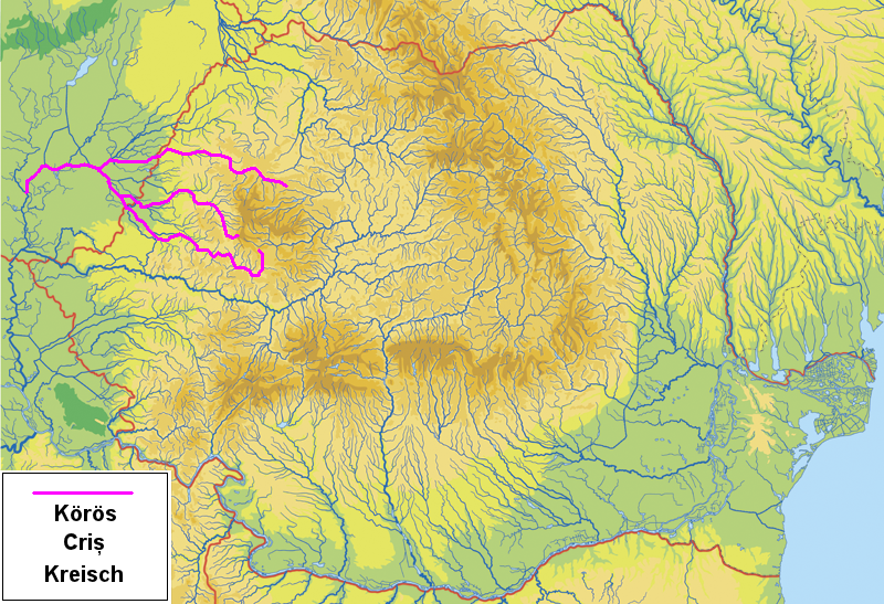


Course and principal tributaries
The Körös is not a single spring-fed river but a network of streams that unite in stages. The three main headwater rivers are:
- Fehér‑Körös (White Körös; Romanian: Crișul Alb) — length about 235.7 km, with a small portion running in Hungary.
- Fekete‑Körös (Black Körös; Romanian: Crișul Negru) — length about 168 km, crossing the border into Hungary for a segment.
- Sebes‑Körös (Fast or Rapid Körös; Romanian: Crișul Repede) — length about 209 km, with a substantial stretch in Hungary.
The Fehér‑Körös and Fekete‑Körös meet near the town of Gyula to form the Kettős‑Körös (literally “Double Körös”); after additional course they are joined by the Sebes‑Körös to become the Hármas‑Körös (“Triple Körös”). The river continuing from these confluences runs roughly 91.3 km to its mouth at the Tisza near the Hungarian town of Csongrád. When all tributaries are counted, the combined river system length is approximately 741.3 km and the catchment area is about 27,537 km².
Physical characteristics and landscape
From the confluence of the headwaters the lower reaches run across a very flat, low‑lying region: roughly the last 195 km of the system are almost wholly level terrain. Prior to the major 19th‑ and 20th‑century river regulation works the Körös formed a broad marshy belt with many meanders and oxbow lakes; remnants of that wetland network survive today as isolated lakes and marshes. Drainage channels and collector canals were constructed to control floods and reclaim land for agriculture, including the Canalul Colector Criș which drains areas between some of the Criș headwaters and terminates in the Romanian commune of Toboliu.
Human uses, management and ecology
Historically the Körös floodplain supported rich habitats and seasonal wetlands. Since large‑scale regulation, the river has been managed for flood protection, improved drainage and agricultural irrigation. Flood control infrastructure, channel straightening and embankments have reduced the natural flood dynamics; these interventions improved arable farming and protected settlements such as Gyula, Gyomaendrőd and Csongrád but also altered habitats for fish, birds and floodplain vegetation. Today conservation efforts and water management balance agricultural demands with attempts to preserve remaining wetlands and oxbow lakes.
History, culture and names
The river system has been an important corridor for human settlement since prehistoric times. Archaeological discoveries along its banks gave the name to the Neolithic Körös culture, an early farming culture of the Carpathian Basin. In ancient sources the river appears with forms such as Crisus, Grisia, Crisia or Gerasus. Linguistically and regionally the waterways are known by several names: Hungarian Körös, Romanian Criș, and German Kreisch. Locally the compound names Kettős‑Körös and Hármas‑Körös are used to indicate the point at which two or three headwaters have joined.
Notable facts and distinctions
The Körös/Criș system is a cross‑border watercourse with both natural and cultural significance. It exemplifies how river regulation in the 19th and 20th centuries transformed Central European lowland environments for agriculture and settlement, while also leaving a legacy of wetlands and archaeological sites. The stream names (White, Black and Rapid) reflect local perceptions of flow and appearance, and the system’s cumulative statistics—total length and catchment area—underscore its importance in the hydrology of the Tisza basin.
Black Screech
The Black Kreish has a length of 144 km, the source is located in the Western Romanian Carpathians near Băița (Hungarian Rézbánya). It flows through the towns of Nucet, Ștei (Hungarian: Vaskohsziklás) and Beiuș (Hungarian: Belényes).
Related articles
Author
AlegsaOnline.com Körös (Criș) — river of the Great Hungarian Plain Leandro Alegsa
URL: https://en.alegsaonline.com/art/54307