Koblenz: history, geography, culture and key landmarks
Koblenz is a German city at the confluence of the Rhine and Moselle rivers. This article summarizes its geography, history, institutions, economy, sights and cultural importance.
Overview
Koblenz is a city in northern Rhineland-Palatinate, Germany, with about 107,000 inhabitants. It is one of the principal urban centres of the state and serves as an administrative seat for the surrounding district. Koblenz combines a long riverine tradition with modern educational and cultural institutions.
Image gallery
10 Images


Geography and landmarks
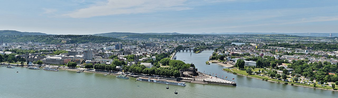
The city occupies a strategic point where the Rhine and Moselle rivers meet. That confluence is marked by the famous Deutsche Eck (German Corner), a promontory and popular viewing spot. On the opposite bank stands the Ehrenbreitstein Fortress, an extensive defensive complex above the Rhine that dominates the skyline. The surrounding landscape includes steep, vine-covered hills that belong to a historically important wine region.
History and development
Koblenz traces its origins to antiquity, when the area served as a Roman military and trading site. Through the Middle Ages the town grew as a market and ecclesiastical centre. Its fortunes rose and fell with regional powers; it later formed part of various German states and experienced heavy damage during the Second World War followed by extensive reconstruction and urban renewal in the postwar period.
Institutions, economy and transport
Today Koblenz hosts branches of universities and research institutions, including Campus Koblenz of a regional university, and provides public administration for the Mayen-Koblenz district. The local economy mixes services, light industry, tourism and river-related commerce. Good rail and river links make Koblenz an important transport hub between the Ruhr, Frankfurt and southwestern Germany.
Culture, tourism and notable facts
The city offers museums, concert venues and festivals that draw visitors throughout the year. Typical highlights include historic fortifications, riverside promenades and regional wine events. Koblenz lies close to the Upper Middle Rhine Valley, a UNESCO World Heritage area that emphasizes the region's cultural landscape and medieval castles.
Quick reference
- Location: Rhine–Moselle confluence
- Population: about 107,000 (city)
- Key sites: Deutsches Eck, Ehrenbreitstein Fortress, riverside quarters
- Main roles: regional administration, education, tourism


Geography
Geographical position
Koblenz is located at the German Corner, an estuary formed by the Moselle and the Rhine. The nearest major cities are Bonn (about 60 km down the Rhine), Wiesbaden and Mainz (about 90 km up the Rhine). Koblenz is bordered by the foothills of the Hunsrück in the south and the slightly hilly landscape of the Maifeld (foothills of the Eifel) in the west. The districts to the right of the Rhine in the east of the urban area lie in the foothills of the Westerwald and reach, in part with a steep gradient, close to the river.
The districts located between the Moselle and the Rhine in the south are partly forested with lush mixed trees and form the "green lung" and local recreation area of Koblenz. This section of the Rhine belongs to the Middle Rhine.
According to the Federal Office of Cartography and Geodesy, Koblenz lies at 73 m above sea level. The German corner is at 64.7 m height. The highest elevation completely located in the city area is with 382 m the Kühkopf in the city forest. The highest point of the city area with 385 m is located on the border to the city of Rhens on the northern slope of the Maulbeerkopf, whose 395 m high peak is located on Rhenser city territory.
Neighboring communities
The independent city of Koblenz borders on three administrative districts:
- in the northeast to the Westerwaldkreis (Simmern and Eitelborn),
- in the east to the Rhine-Lahn district (Lahnstein, Fachbach and Miellen) and
- in the south, west and north to the administrative district Mayen-Koblenz (Rhens, Waldesch, Dieblich, Winningen, Kobern-Gondorf, Mülheim-Kärlich, Kaltenengers, Urmitz, St. Sebastian, Bassenheim, Niederwerth, Vallendar, Bendorf and Urbar).
In the close vicinity of the city there is also the district of Neuwied in the north and the Rhine-Hunsrück district in the south.
City breakdown
The urban area of Koblenz is divided into 30 (statistical) districts. The division was carried out within the framework of the small-scale division on the recommendation of the German Association of Cities. A special feature is the Karthause, which is statistically subdivided into Karthause North, Karthause-Flugfeld and Karthäuserhofgelände, and the Südliche Vorstadt, which is statistically subdivided into Mitte and Süd. The Karthause and the Südliche Vorstadt, on the other hand, have historically developed from uniformly grown structures and are regarded by the population as a district only in their entirety. However, there is no decision by the Koblenz City Council on the status as a district of these statistical subdivisions.
Nine city districts form a total of eight local districts, whose concerns are represented vis-à-vis the city by a local council and a local head. The remaining 21 districts have no local councils.
The 30 districts of Koblenz are Altstadt, Arenberg (local district together with Immendorf), Arzheim (local district), Asterstein, Bubenheim (local district), Ehrenbreitstein, Goldgrube, Güls with Bisholder (local district), Horchheim, Horchheimer Höhe, Immendorf (local district together with Arenberg), Karthause (with the statistical districts Karthause Nord, Karthause-Flugfeld and Karthäuserhofgelände), Kesselheim (local district), Lay (local district), Lützel, Metternich, Moselweiß, Neuendorf, Niederberg (with Neudorf), Oberwerth, Pfaffendorf, Pfaffendorfer Höhe, Rauental, Rübenach (local district), Stolzenfels (local district), Südliche Vorstadt (with the statistical districts Mitte and Süd) and Wallersheim.
See also: List of the districts of Koblenz
Climate
Koblenz lies in the so-called temperate zone with a moderately cool climate and prevailing westerly winds. In the West German lowlands and the Rhine rift valley, these winds from the Atlantic and the North Sea bring about 700 mm of precipitation annually. Koblenz is humid all year round, with an average annual temperature of 10.8 °C and an annual precipitation of 674 mm. Precipitation is low. They are in the lower quarter of the values recorded in Germany. Lower values are recorded at 23 % of the measuring stations of the German Weather Service. The driest month is February, the most precipitation falls in July. In July, 2.4 times more precipitation falls than in February. Precipitation varies greatly. Lower seasonal variations are recorded at 72% of the monitoring stations. The coldest month is January with a temperature of 2.7 °C, the warmest month is July with an average of 19.5 °C. The heat record is 39.5 °C. The heat record is 39.4 °C and was measured on 18 June 2002 in Koblenz. Due to its location in the valley of the surrounding low mountain ranges Eifel, Hunsrück and Westerwald as well as the proximity of three rivers (Rhine, Moselle, Lahn), Koblenz often develops a "Kesselklima", which is often quite humid in summer compared to the surrounding area. In the autumn and winter months, tough foggy days are not uncommon, while on the heights of the low mountain ranges cloudless skies prevail.
| Monthly average temperatures and precipitation for Koblenz
Source : http://www.klimadiagramme.de/Deutschland/koblenz2.html | |||||||||||||||||||||||||||||||||||||||||||||||||||||||||||||||||||||||||||||||||||||||||||||||||||||||||||||||||||||||||||||||||||||||


History
→ Main article: History of the city of Koblenz
In the course of its history, Koblenz belonged to various states and territorial authorities:

The history of the city of Koblenz is very changeable and characterized by warlike confrontations during numerous border conflicts as well as a great structural change. The area of Koblenz has been settled since the Stone Age. The Romans built a fortified urban settlement here for the first time. The Confluentes fort was built in today's old town centre to secure the Roman Rhine Valley Road (Mainz-Cologne-Xanten) and the Niederberg fort was built in Niederberg to secure the Limes and the first bridges over the Rhine and Moselle. Koblenz is thus one of the oldest cities in Germany. After the retreat of the Roman troops in the 5th century, Koblenz was conquered by the Franks, who founded a royal court here. In 842, negotiations between the three grandsons of Charlemagne took place in the Kastor Church, which was consecrated in 836. These negotiations finally led to the division of the Frankish Empire in the Treaty of Verdun in 843.
In the following reign of the archbishops and electors of Trier, Koblenz continued to flourish and a multitude of cultural treasures in the form of churches, castles and fortifications were created. The Ehrenbreitstein fortress gradually developed from the castle built on the Ehrenbreitstein around 1020. In uncertain times, the greatest sanctuaries were kept in this most secure castle of the Electorate. In the 12th century the Archbishops of Trier built the Florins Church and the Liebfrauen Church. In the 13th century, Stolzenfels Castle was built as the Electorate's customs castle on the Rhine, as well as the Alte Burg (Old Castle) as a stronghold against the citizens striving for more independence. In the following century, with the construction of the Balduin Bridge, a fixed Moselle crossing was made possible for the first time since the Romans. During the Thirty Years' War, Elector Philipp Christoph von Sötern moved his official residence from Trier to the newly built Philippsburg Castle at the foot of the Ehrenbreitstein, which had meanwhile been converted into a fortress. In 1786, Elector Clemens Wenzeslaus of Saxony moved to the Electoral Palace in Koblenz. From here he ruled the electoral state until its end in 1794, when the country and Koblenz were conquered by the French revolutionary army. From 1789 to 1794 (and thereafter to Ehrenbreitstein Fortress until 1799), counter-revolutionary forces around the brothers of Louis XVI had retreated to Coblence and, thanks to their uncle Wenzeslaus, administered it relatively independently as "Little Paris" until it was then conquered by Severin Marceau.
The following French period shaped Koblenz (French Coblence) far beyond its end. The term "Schängel" was coined, which is still used today to refer to anyone born in Koblenz. In 1801, at the Peace of Lunéville, Koblenz also formally fell to France and became the capital of the French Département de Rhin-et-Moselle. The end of this French period came in 1814 with the occupation of Koblenz by Russian troops.
As a result of the Congress of Vienna in 1814/15, the Rhenish possessions of the Trier Electorate and thus also Koblenz were transferred to Prussia. The city, at first the seat of the chief presidium of the province of the Grand Duchy of the Lower Rhine, later the capital of the Prussian Rhine Province, was expanded as Fortress Koblenz into one of the strongest fortification systems in Europe. In the 19th century, not only powerful fortifications were built in Koblenz, but also Stolzenfels Castle was rebuilt and a ship's bridge now crossed the Rhine. The first railway entered Koblenz in 1858 over the newly built Moseleisenbahn bridge. With the subsequent expansion of the railway network, further crossings over the Rhine and Moselle were built with the construction of the Pfaffendorf Bridge, the Gülser Railway Bridge and the Horchheimer Railway Bridge. Due to the advancement of war technology, the fortifications lost their importance from the second half of the 19th century onwards. Since 1890 the city fortifications were completely demolished and the settlement area could now be extended beyond the narrow city limits for the first time. In honour of Emperor Wilhelm I, who had lived in Koblenz for a long time with his wife Augusta before his accession to the throne, the Emperor Wilhelm Monument was inaugurated at the mouth of the Moselle at the Deutsches Eck in 1897 in the presence of Emperor Wilhelm II.
The 20th century was marked by major structural changes as well as a considerable expansion of the settlement area. Thus, the Sacred Heart Church was inaugurated on the site of the former Löhr Gate in 1903. Already one year before, a magnificent main railway station was completed in the new southern suburb. After the end of the First World War, Koblenz was occupied first by American and then by French troops. In 1932, the complete reconstruction of the Pfaffendorf Bridge began, resulting in a completely new road bridge. Two years later followed the inauguration of a new Moselle crossing, as the Balduin Bridge was no longer sufficient for the growing volume of traffic.
The air raids on Koblenz during the Second World War were drastic, destroying 87% of the city. In 1944, Lancaster bombers of the British Royal Air Force reduced the centre of Koblenz to rubble. On March 18 and 19, 1945, the US Army's 87th Infantry Division captured Koblenz. The city slowly recovered from the events of the war, but the historic townscape remained partially lost. In the post-war period, Koblenz became part of the French occupation zone and consequently of the new state of Rhineland-Palatinate. In the early years it was also its provisional seat of government. At the Rittersturz Conference in 1948, one of the fundamental decisions was made to merge the three western occupation zones ("Trizone") into the Federal Republic of Germany and thus to temporarily separate it from the Soviet zone. As a result of West German rearmament from the mid-1950s, Koblenz once again received a very large German garrison. The last parts of the French garrison left in 1969. Koblenz passed the 100,000 population mark in 1962, becoming a major city. A major bridge building project was completed with the completion of the South Bridge in 1975. During the construction of the Rhine bridge, two tragic accidents occurred in which 19 workers were killed. In 1992, the city of Koblenz celebrated the 2000th anniversary of the founding of the city.
On 4 December 2011, around 45,000 residents had to leave their homes. The reason for the most extensive evacuation of a major German city since 1945 was the defusing of some explosive ordnance; among them was a British air mine from the Second World War.
Incorporations
Formerly independent communities and parishes that were incorporated into the city of Koblenz:
| Year | Locations | increment in | Year | Locations | increment in | |
| July 1, 1891 | Neuendorf with Lützel | 547 | June 7, 1969 | Kesselheim | 484 | |
| April 1, 1902 | Moselle White | 382 | June 7, 1969 | Kapellen-Stolzenfels | 248 | |
| October 1, 1923 | Wallersheim | 229 | November 7, 1970 | Arenberg-Immendorf | 900 | |
| July 1, 1937 | Ehrenbreitstein | 120 | November 7, 1970 | Arzheim | 487 | |
| July 1, 1937 | Horchheim | 772 | November 7, 1970 | Bubenheim | 314 | |
| July 1, 1937 | Metternich | 483 | November 7, 1970 | Güls with Bisholder | 795 | |
| July 1, 1937 | Low Mountain | 203 | November 7, 1970 | Lay | 249 | |
| July 1, 1937 | Pfaffendorf with Asterstein | 369 | November 7, 1970 | Rübenach | 1288 |
Population development
Due to numerous incorporations, the population of the city doubled from 45,000 in 1900 to 91,000 in 1939. During World War II, Koblenz lost about 80% of its inhabitants due to the almost complete destruction of the city. In April 1945, 19,076 card recipients were identified in the entire city area by the Nutrition Office. In 1958, the population reached the pre-war level again. In 1961, the city's population exceeded 100,000, making it a major city.
On November 7, 1970, the population of the city increased by almost 20,000 people to about 120,000 inhabitants due to the incorporation of several localities - a historic high. In 2004, the proportion of non-German residents in the total population was 9.3% (10,021 people), according to the city administration. The largest proportion of these were citizens of Turkey (1963), Ukraine (872), Serbia and Montenegro (785) and Russia (711). At the end of June 2005, according to an update of the Rhineland-Palatinate Statistical Office, 106,501 people were living in Koblenz with their main place of residence. After that, especially after the conclusion of the Federal Garden Show in 2011, the number of inhabitants rose steadily again and exceeded the 110,000 mark on 31 May 2014, the highest since 1992.
The following overview shows the population figures according to the respective territorial status. Up to 1833, these are mostly estimates, thereafter census results (¹) or official updates of the respective statistical offices or the municipal administration itself. From 1843 onwards, the data refer to the "local population", from 1925 onwards to the resident population and since 1987 to the "population at the place of principal residence". Before 1843, the number of inhabitants was determined according to non-uniform survey methods.
| Year | Inhabitants |
| 1469 | 1.193 |
| 1663 | 1.409 |
| 1778 | 7.475 |
| 1800 | 7.992 |
| 1808 | 11.077 |
| 1812 | 11.793 |
| 1820 | 11.324 |
| 1836 | 13.307 |
| 1 December 1840 ¹ | 18.387 |
| 3 December 1846 ¹ | 19.475 |
| 3 December 1852 ¹ | 22.033 |
| 3 December 1861 ¹ | 22.175 |
| 1 December 1871 ¹ | 24.902 |
| 1 December 1875 ¹ | 29.300 |
| Year | Inhabitants |
| 1 December 1880 ¹ | 30.500 |
| 1 December 1885 ¹ | 31.669 |
| 1 December 1890 ¹ | 32.664 |
| 2 December 1895 ¹ | 39.639 |
| 1 December 1900 ¹ | 45.147 |
| 1 December 1905 ¹ | 53.897 |
| 1 December 1910 ¹ | 56.487 |
| 1 December 1916 ¹ | 49.421 |
| 5 December 1917 ¹ | 50.067 |
| October 8, 1919 ¹ | 56.676 |
| 16 June 1925 ¹ | 58.161 |
| 16 June 1933 ¹ | 65.257 |
| 17 May 1939 ¹ | 91.098 |
| 31 December 1945 | 47.982 |
| Year | Inhabitants |
| 29 October 1946 ¹ | 52.414 |
| 13 September 1950 ¹ | 66.444 |
| 25 September 1956 ¹ | 84.275 |
| 6 June 1961 ¹ | 99.240 |
| 31 December 1965 | 103.425 |
| 27 May 1970 ¹ | 101.374 |
| 31 December 1973 | 120.564 |
| 31 December 1975 | 118.394 |
| 31 December 1980 | 113.676 |
| 31 December 1985 | 110.843 |
| 25 May 1987 ¹ | 108.246 |
| 31 December 1990 | 108.733 |
| 31 December 1995 | 109.219 |
| 31 December 2000 | 107.950 |
| Year | Inhabitants |
| 30 June 2005 | 106.501 |
| 31 December 2006 | 106.421 |
| 31 December 2010 | 106.501 |
| 9 May 2011 ¹ | 107.825 |
| 31 May 2013 | 109.209 |
| 31 May 2014 | 110.002 |
| 31 December 2014 | 111.434 |
| 31 December 2015 | 112.586 |
| 31 December 2016 | 113.605 |
| 31 December 2017 | 113.844 |
| 31 December 2020 | 113.303 |
¹ Census result


Related articles
Author
AlegsaOnline.com Koblenz: history, geography, culture and key landmarks Leandro Alegsa
URL: https://en.alegsaonline.com/art/54066