Klagenfurt am Wörthersee — capital city of Carinthia, Austria
Klagenfurt am Wörthersee is the capital of Carinthia in southern Austria, set near Lake Wörthersee. It is a regional center for culture, education, transport and tourism with a historic Old Town.
Klagenfurt am Wörthersee, commonly called Klagenfurt, is the largest city and administrative capital of the Austrian state of Carinthia. It lies in the lake district of southern Austria and is closely associated with nearby Lake Wörthersee. The city is multilingual in heritage and is known in Slovene as Celovec. Klagenfurt functions as a regional hub for administration, education, commerce and visitors.
Image gallery
10 Images


Location and character
Klagenfurt sits in a basin near the eastern end of Lake Wörthersee and administratively forms its own district within the state. The urban area combines a compact historic center of narrow streets and squares with surrounding residential neighborhoods, parks and light industrial zones. The climate is temperate with warm summers that draw tourists to the lakes and outdoor recreation.
History and development
The settlement grew from medieval origins into a fortified market town and later the capital of the region. Over centuries it developed civic institutions, trade links and cultural life that reflect both Germanic and Slavic influences. In more recent times Klagenfurt expanded with modern infrastructure while preserving many historic buildings in its Old Town.
Economy, education and transport
The local economy blends public administration, services, retail, education and tourism. The city hosts a university and other research and cultural institutions that contribute to its regional importance. Klagenfurt is connected by road and rail to larger Austrian cities, and an airport near the city offers seasonal and regional flights, supporting both business and leisure travel.
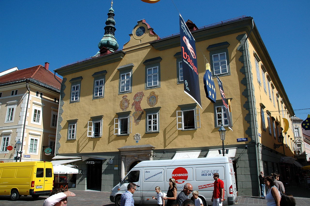
Landmarks and culture
Visitors to Klagenfurt commonly explore its Old Town, public squares and civic monuments. The city is associated with folklore and local symbols; it stages festivals, concerts and exhibitions through the year and has theaters, galleries and museums that serve residents and tourists alike.
Notable facts
- Capital of Carinthia and an independent district within the state.
- Close relationship to Lake Wörthersee and lakeside tourism.
- Multicultural heritage with German as the main language and Slovene minority traditions.
- Regional transport links and an airport serving the area.
Klagenfurt combines a compact historic core with modern civic life, making it an important center in southern Austria for residents, students and visitors.
Location
Klagenfurt is located on the Klagenfurter Feld in the centre of the Klagenfurt Basin and stretches for about 15 km each in a north-south and east-west direction. The city encompasses the entire eastern shore of Lake Wörthersee, the areas north of which are part of the Feldkirchen-Moosburger Hügelland and the Glantaler Bergland. Parts of the northern municipality of Wölfnitz already belong to the Zollfeld, the south of Klagenfurt lies at the foot of the Sattnitz-Höhenzug.
The town centre lies at an altitude of about 450 m above sea level; the highest point within the municipal area is the Ulrichsberg at 1022 m above sea level. The lowest point is the Gurkerbrücke (420 m) on the eastern border of the town.
About one third of the 120 km² municipal area is designated as agricultural land (33.4 %) and forest (32.9 %) respectively. 19.3 % of the area of Klagenfurt is used as building land, 2.2 % are water bodies and 1.3 % are gardens. The remaining 10.9 % fall under "other types of use", which include traffic routes, quarrying areas and wasteland.
The Adriatic Sea is only about 150 kilometres away from Klagenfurt; Trieste can be reached by motorway in about two hours.
Geology
The entire Klagenfurt basin was filled by the Drau glacier during the Ice Age. After the melting of the ice masses, alluvial cones of the Glan formed the subsoil of today's northern city area and the Zollfeld consisting of ice-age gravels. At the same time, Lake Wörthersee was formed, which some 4000 years ago reached as far as today's city centre, where a large area of moorland formed as a result of gradual silting up. The hills in the north of the city consist mainly of old crystalline mica schists and Paleozoic phyllites, green schists and limestones, the Sattnitz range south of Klagenfurt of conglomerates.
Climate
Klagenfurt has a temperate continental climate with relatively large temperature fluctuations between the seasons. Due to the inversion weather conditions prevailing in the Klagenfurt basin, an above-average frequency and often long-lasting haze and fog formation is typical for this area. In early and mid autumn this is mainly ground fog, while in late autumn and winter it is mostly high fog. Characteristic is also a general lack of wind. The winters, which are cold compared to the Austrian average, can occasionally be alleviated by the foehn blowing through the Karawanken to the south.
The long-term average annual temperature (determined in the years 1961 to 1990) is 7.7 °C. The mean temperature in Klagenfurt in 2007 was 9.7 °C.
| Klagenfurt | ||||||||||||||||||||||||||||||||||||||||||||||||
| Climate diagram | ||||||||||||||||||||||||||||||||||||||||||||||||
| ||||||||||||||||||||||||||||||||||||||||||||||||
| Monthly average temperatures and precipitation for Klagenfurt
Source: | |||||||||||||||||||||||||||||||||||||||||||||||||||||||||||||||||||||||||||||||||||||||||||||||||||||||||||||||||||||||||||||||||||||||||||||||||||||||||||||||||||||||||||||||||||||||||||||||||||||||||||||||||||||||||||||||||||||||||||||
Climate table for the period from the year 2000 to the year 2013, it shows the temperature change upwards, the annual average temperature has increased by 1.9 °C to 9.9 °C compared to the measurement period from the year 1971 to the year 1990. Also, since the year 2000, there have been eleven years with more than 2000 hours of sunshine. On average, the sunshine duration has increased to 5.8 hours per day.
| Klagenfurt Airport | ||||||||||||||||||||||||||||||||||||||||||||||||
| Climate diagram | ||||||||||||||||||||||||||||||||||||||||||||||||
| ||||||||||||||||||||||||||||||||||||||||||||||||
| Monthly average temperatures and precipitation for Klagenfurt Airport
Source: | |||||||||||||||||||||||||||||||||||||||||||||||||||||||||||||||||||||||||||||||||||||||||||||||||||||||||||||||||||||||||||||||||||||||||||||||||||||||||||||||||||||||||||||||||||||||||||||||||||||||||||||||
Waters
In the north of the city area, the Glan flows through Klagenfurt in a west-easterly direction; in the east, the Gurk brushes against the district of Hörtendorf, shortly before picking up the Glan in Ebenthal. There are two canals in the city centre that were man-made in the 16th century: the Lendkanal, which still connects the centre with Lake Wörthersee, and the Feuerbach, which has now been almost completely absorbed into the city's underground sewer system. Flowing through the southern districts, the 8.8 km long Glanfurt (popularly known as "Sattnitz") drains Lake Wörthersee into the Glan. Other, smaller watercourses include the Kerbach, the Raba, and the Struga, Wölfnitz and Viktringer Bach.
The entire eastern shore of Lake Wörthersee belongs to the urban area of Klagenfurt, which has included the name of the lake in its own name since mid-2007. There are also a number of ponds in Klagenfurt. The Hallegger ponds, which are located in a nature reserve below Halleg Castle, are among the largest.
City breakdown
Klagenfurt is divided into 15 municipal districts. Until 1848, the city area comprised only the present-day inner city; with the formation of political municipalities in Austria, the immediately adjacent four suburbs (St. Veiter, Völkermarkter, Viktringer and Villacher Vorstadt) were initially added to Klagenfurt in 1850. Apart from a minor expansion of the city in 1893, Klagenfurt only reached its present size in the 20th century through the incorporation of previously independent municipalities in 1938 (districts IX to XII) and 1973 (districts XIII to XV).
The four districts of the Inner City roughly form a square of squares, numbered clockwise starting at the top left (in the northwest corner). The next four districts (5-8) enclose the square roughly circularly, the numbering starts at the top, in the north and goes clockwise. The same applies to the districts 9 to 12, which are larger in area and again form a belt of sectors in the main cardinal directions. The three outermost and youngest districts are numbered clockwise, like all zones, but they are discreetly winged, i.e. they are not connected with each other; the counting now starts in the south (southwest) with 13, runs over 14 in the northwest to the relatively small 15th district in the east.
| Municipal districts with population figures Status 1 January 2021 | |||||
| I-IV | inner city | 2582 | |||
| V | St. Veiter suburb | 3991 | |||
| VI | Völkermarkt suburb | 4737 | |||
| VII | Viktringer suburb | 3365 | |||
| VIII | Villach suburb | 8392 | |||
| IX | Annabichl | 11.342 | |||
| X | St. Peter | 20.510 | |||
| XI | St. Ruprecht | 7284 | |||
| XII | St. Martin | 21.570 | |||
| XIII | Viktring | 9865 | |||
| XIV | Wölfnitz | 5535 | |||
| XV | Hörtendorf | 2592 | |||
Within the districts, the 25 cadastral municipalities are the next lower administrative unit (with the non-official Slovenian names in brackets):
Klagenfurt, Blasendorf (Blažnja vas), Ehrenthal, Goritschitzen (Goričica), Großbuch, Großponfeld, Gurlitsch I, Hallegg (Helek), Hörtendorf (Trdnja vas), Kleinbuch, Lendorf (Dhovše), Marolla, Nagra, Neudorf (Nova vas), St. Martin bei Klagenfurt, St. Peter am Karlsberg, St. Peter bei Ebenthal, St. Peter bei Tentschach, St. Ruprecht bei Klagenfurt, Stein (Zakamen), Tentschach, Viktring (Vetrinj), Waidmannsdorf (Otoče), Waltendorf (Vapoča vas), Welzenegg
(Gurlitsch II is a cadastral municipality in the adjacent municipality of Krumpendorf).


Population
Population
As of 1 January 2021, the city of Klagenfurt am Wörthersee had 101,765 inhabitants. On 22 February 2016, the city recorded 100,000 inhabitants for the first time. In the past, the city of Klagenfurt's attempt to incorporate the neighbouring municipalities of Ebenthal in Carinthia and Krumpendorf am Wörthersee failed due to the resistance of the local population. The incorporation of at least one of the two neighbouring municipalities, as proposed by the City of Klagenfurt, would have increased the population of the City of Klagenfurt am Wörthersee to over 100,000 inhabitants much earlier.
Population development
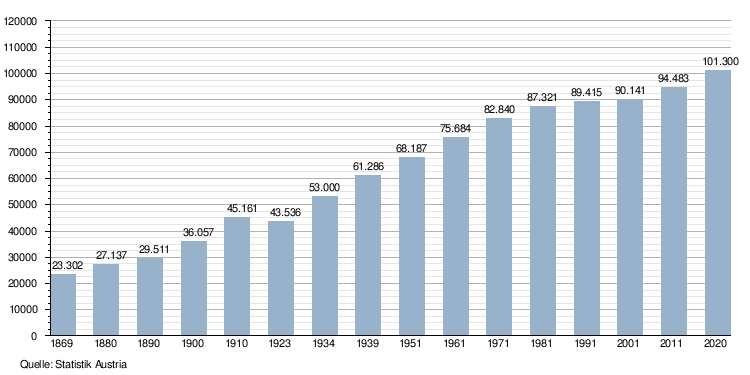
Around the year 1400 Klagenfurt had about 3000 inhabitants. After the expansion of the city in the 16th and 17th century, there were already 7500 around the year 1750 and around the year 1820 the 10,000 inhabitant mark was exceeded.
When political municipalities were formed in 1850, the present-day suburbs were added to Klagenfurt, so that by the 1869 census the city already had over 15,000 inhabitants.
In the 20th century, the incorporation of the municipalities of Annabichl, St. Peter, St. Ruprecht and St. Martin as well as the municipalities of Hörtendorf, Viktring, Wölfnitz and St. Peter/Bichl led to a considerable increase in Klagenfurt's urban area and population.
| Year | Number | Comments |
| 1780 | 9.686 | |
| 1830 | 12.490 | |
| 1846 | 10.352 | |
| 1857 | 13.712 | |
| 1869 | 15.285 | |
| 1880 | 18.747 | 17,119 German speakers (91.3%), 629 Slovenes (3.4%) - (18,322 Catholics, 310 Protestants, 94 Jews, 21 Others) |
| 1890 | 19.756 | 18,134 German-speaking (91.8 %), 723 Slovenes (3.7 %) (incl. garrison) - (19,132 Catholics, 488 Protestants, 115 Jews, 21 Others) |
| 1900 | 24.284 | incl. garrison, 1,671 Slovenes (6.9 %) |
| 1910 | 28.911 | 25,591 German speakers (88.5 %), 1,758 Slovenes (6.1 %), 130 others, 1,432 foreigners |
| 1923 | 27.423 | |
| 1934 | 48.973 | |
| 1939 | 53.516 | 43,917 Catholic, 4,334 Protestant, 321 other Christians, 9 Jews |
| 1951 | 62.782 | |
| 1961 | 69.218 | |
| 1971 | 82.512 | 987 Slovenes (1.2 %) |
| 1981 | 87.321 | 919 Slovenians (1.1 %) |
| 1991 | 89.415 | |
| 2001 | 90.141 | 80,610 German speakers (89.4 %), 2,958 Croats (3.3 %), 1,722 Slovenes (1.9 %), 966 Serbs (1.1 %) |
| 2011 | 94.383 | |
| 2018 | 100.316 |
Population structure
The share of foreign citizens in Klagenfurt's population was around 10% in 2010, about one third of whom (32.8%) were citizens of the European Union.
13,795 citizens of Klagenfurt were not born in Austria. This corresponds to a share of 14.8 %. The majority of Klagenfurt's foreign-born citizens come from the countries of the former Yugoslavia (5799 persons or 6.2 % of the total population), the second largest group are Germans (2267 persons or 2.4 %).
According to the figures of Statistics Austria, as of 1 January 2014, 12,013 of the approximately 97,000 Klagenfurters had a non-Austrian citizenship (this corresponds to 12.4 % of Klagenfurt's population). 16,056 Klagenfurters were born abroad (this corresponds to 16.6 % of Klagenfurt's population). Due to the fact that the categorisation of nationals was based on the country of birth, these figures do not include people with a second-generation migration background (children born in Austria to foreign parents).
In the 2001 census, 89.4% of the population indicated German as their colloquial language. The second largest language group was Croatian (3.3%), followed by Slovene (1.9%).
Religious denominations
About two thirds of the population of Klagenfurt (2001: 68.8 %) profess the Roman Catholic faith. The urban area of Klagenfurt is assigned to 18 Catholic parishes, 16 of which are united in the deanery Klagenfurt-City, one each in the deanery Klagenfurt-Land and Tainach:
- Deanery Klagenfurt-City:
|
|
- Deanery Klagenfurt-Land: Parish St. Martin am Ponfeld
- Deanery of Tainach: Parish of St. Thomas am Zeiselberg (mostly in the district of Klagenfurt-Land, but also includes the Klagenfurt district of Hörtendorf with the daughter church of St. Margarethen)
7.5 % of the inhabitants belong to the Protestant churches A.B. and H.B.. The two Protestant parishes of Klagenfurt (Johanneskirche and Christuskirche) belong to the Superintendent's Office of Carinthia and East Tyrol with its seat in Villach. In addition, 3.0 % of the population profess Islam, 1.5 % the Orthodox Church and 0.6 % each the Jehovah's Witnesses and the Old Catholic Church (St. Mark's Church). Other denominations located in Klagenfurt are the Free Baptist Church, the Pentecostal Church, the Evangelical Church, the Free Evangelical Church, the Serbian Orthodox Church, the Seventh-day Adventists, the New Apostolic Church and the Church of Jesus Christ of Latter-day Saints.
Today only the small Israelite cemetery in St. Ruprecht and a memorial plaque in Platzgasse 3, on the site of the former prayer house, which was devastated during the November pogroms of 1938 and later destroyed by bombs, bear witness to the former Jewish community (1934: 269 members, 1951: 9, 1968: 15). The few citizens of Jewish faith still living in Klagenfurt today belong administratively to the religious community of Graz.
16.1% of the citizens of Klagenfurt have no religious affiliation.

Related articles
Author
AlegsaOnline.com Klagenfurt am Wörthersee — capital city of Carinthia, Austria Leandro Alegsa
URL: https://en.alegsaonline.com/art/53901