Kayseri
This is the sighted version that was marked on May 7, 2021. There is 1 pending change that needs to be sighted.
![]()
This article is about the city. For the province, see Kayseri (province). For the statistical region, see Kayseri (NUTS region).
Template:Infobox Place in Turkey/Maintenance/CountyWithoutInhabitantsOrArea
Table of contents
· 1 History
· 2 Population
o 2.1 Population figures according to censuses 1927 to 2000
· 3 Lord mayor
· 4 Kitchen
· 5 Education and research
· 6 Places of interest
o 6.1 Development of Erciyes Mountain into a winter sports resort
o 6.2 Reforestation of Ali Mountain
· 7 Climate
· 8 Media
· 9 Sports
o 9.1 Kadir Has Stadium and Atatürk Sports Center
· 10 Economy and traffic
o 10.1 Erkilet Airport
o 10.2 KayseRay streetcar
o 10.3 Shopping centers
· 11 Town twinning
· 12 personalities
· 13 Gallery
· 14 Web links
· 15 Individual references
Kayseri (Latin Caesarea, named in honor of the Roman emperor Tiberius; Greek Καισάρεια Kaisareia, Armenian Կեսարիա Kesaria), previously Mazaka (Armenian Մաժաք Mazhak', Greek Μαζάκα) or Eusebeia (Greek Ἐυσεβεία), is the capital of the eponymous province of Kayseri in Cappadocia, Turkey. In 2000, the city had a population of 536,392; today's Büyükşehir Belediyesi (German: Großstadtkommune), which has been congruent with the province of Kayseri since 2013, has a population of just under 1.50 million (as of 2020).
Kayseri is located at 1054 m at the foot of the extinct volcano Erciyes (3916 m), which with its eruptions was responsible for the tuff layers in Cappadocia.
History
The site of the present city was still interspersed with salt lakes and swamps until the 4th century, some of which were drained only in the last century. Since Hittite times the place was called Mazaka. In Hellenistic times, the kings of Cappadocia resided here and Eusebeia, as Mazaka was also called at that time, formed one of the two national centers along with Tyana in the south.
According to Strabon, the city was still unfortified and surrounded by predatory tribes in his time. The surrounding land was barren, sandy and stony, the city itself "waterless". Numerous "fire pits" seem to have survived from the volcanic activity around Erciyes at that time. The supply of wood over the slopes of the volcanic mountain was therefore also difficult. In the plain around the city flowed the swampy Melas River (Greek Μέλας), today's Karasu Çayı (both names mean "black river"), a tributary of the Delice Çayı, called Cappadox in ancient times and in turn a tributary of the Kızılırmak or Halys. By damming the Melas at its mouth, the Cappadocian king Ariarathes created a "sea-like lake" with some islands. However, the breach of the dam caused a flood of mud all along the lower reaches of the Halys, namely among the Galatians of Phrygia, who then demanded compensation.
Around 77 BC, the city was captured for the second time by the Armenian Great King Tigranes II, who once again had numerous inhabitants deported to his new capital Tigranokerta in northern Mesopotamia. Only after the conquest of this place by the Romans under Pompeius (69 B.C.) could the resettled population return. With the death of its last king Archelaos, Cappadocia lost its independence in 17 AD and was transformed into the Roman province of Cappadocia under Emperor Tiberius. Mazaka-Eusebeia now served as the provincial capital and was given the name Caesarea (Greek Kaisáreia). After the division of Cappadocia under Emperor Valens, Caesarea was the capital of Cappadocia prima.
According to Christian tradition, Christianity found favor among the citizens of the city early on (1 Pet 1:1 EU). At the beginning of the 3rd century, Caesarea was a center of Christian theological education. Caesarea experienced its heyday in the 4th century. The social works (hospitals, old people's homes, feeding the poor) that Basil of Caesarea established there in the second half of the fourth century were famous in antiquity. The new settlement grew rapidly, while the old quarters gradually decayed (remains can still be found today).
After troubled times, the city was lost to the Byzantine Empire around 1077. In 1082 it came into the possession of the Danishmen, and during the 1st Crusade (1096-1099) temporarily into that of the Crusaders under Gottfried von Bouillon. In the 12th and 13th centuries it was temporarily the residence of the Seljuks and experienced a second period of prosperity. After further conquests, it was ruled by the Mongols. Subsequently Ottoman Kayseri became Mongol again in 1401 under Timur, and Ottoman again from 1468. The following long period of peace allowed an upward development as a provincial city.
Around 1900, the construction of the new town north of the citadel took place. Many buildings from this period have been preserved. Here you can also find the oldest psychiatric clinic of modern times, where therapy was given with the help of music - a revolutionary method of treatment at that time. In the city center there are the walls of the fortress and several Seljuk mosques of the Ulu Cami (centerless columned hall) type.
On December 17, 2016, according to the Doğan Haber Ajansı news agency, an explosion occurred at the entrance gate of Erciyes University. The detonation hit a passing public bus carrying soldiers of the Turkish Armed Forces. According to military sources, 13 people were killed and several injured. Turkey's deputy prime minister, Veysi Kaynak, told NTV television that "insidious interest groups" had targeted members of the Kayseri air force brigade. Just a week earlier, 44 people were killed in bombings in Istanbul.
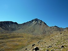
The nearby volcanic mountain Erciyes
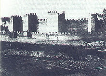
The fortification walls of Kayseri in 1897
Population
By Law No. 3508, the provincial capital of Kayseri was declared a metropolitan municipality (Büyükşehir Belediyesi) and at the same time separated into two counties: Kocasinan and Melikgazi. Later, the area of the "core city" was expanded to three more counties: Hacılar, Talas and İncesu, with the first two counties being newly formed. Finally, Law No. 6360 extended the metropolitan municipality area to all counties/municipalities and declared the villages and municipalities therein as mahalle. This administrative reform came into effect in 2013/2014, scheduled for March 30, 2014 - the day of the local elections.
Under the 2012 Metropolitan Law, the provincial boundary is considered the city boundary. Consequently, the city districts now also count as part of the city. The narrower core city, which consists of the districts of Kocasinan, Melikgazi and Talas, has a population of about 1 million.
Population figures according to censuses 1927 to 2000
The following table provides information on the development of the population figures of the city (Şehir), district (İlçe) and province (İl) of Kayseri. The figures were taken from the results of the censuses of the indicated years published as PDF files, available from the library of the TURKSTAT (TÜİK) and from the census page of the (TÜİK) for the years 1965 to 2000 (only in Turkish).
Since the central county of the provincial capital (Merkez Ilçe) no longer existed as of 1990, the values of the top two rows were obtained by adding the results of Kocasinan and Melikgazi.
| Region | 1927 | 1935 | 1940 | 1945 | 1950 | 1955 | 1960 | 1965 | 1970 | 1975 | 1980 | 1985 | 1990 | 2000 |
| City (Şehir) | 39.544 | 46.181 | 52.467 | 57.864 | 65.488 | 82.405 | 102.596 | 126.653 | 160.985 | 207.037 | 281.320 | 373.937 | 421.362 | 536.392 |
| central circle | 100.006 | 114.781 | 127.875 | 140.861 | 155.699 | 179.651 | 193.560 | 222.699 | 268.482 | 326.459 | 421.123 | 488.429 | 490.143 | |
| Province (İl) | 250.490 | 310.458 | 342.969 | 370.089 | 403.861 | 422.010 | 480.387 | 536.206 | 598.693 | 676.809 | 778.383 | 864.060 | 943.484 | 1.060.432 |
| Turkey | 13.648.270 | 16.158.018 | 17.820.950 | 18.790.174 | 20.947.188 | 24.064.763 | 27.754.820 | 31.391.421 | 35.605.176 | 40.347.719 | 44.736.957 | 50.664.458 | 56.473.035 | 67.803.927 |
· 
Districts with population density
·
Population development
·
Population distribution by gender
Lord Mayor
With date and election result
|
|
|
|
Kitchen
The city is famous for its air-dried beef ham (Pastırma), garlic sausage Sucuk and stuffed dumplings Mantı.
Worth seeing
In the surrounding area there are several places of interest, among others
- The Armenian Church of Saint Gregory the Illuminator
- The excavations of Kültepe (the Bronze Age Kaneš)
- The Hittite rock relief of Fıraktın
- The Hittite rock relief of Hanyeri
- Mimarsinan, the birthplace of the architect Sinan
- In the place Gezi an underground city
- The Soğanlı Valley with numerous cave churches
- The underground city at the foot of Ali Dağı in Talas district.
- The Greek Orthodox Panaghia Church, located in Talas, which was converted into a mosque
- The Kapuzbaşı waterfalls located in the border area with Adana.
- The Sultan Sazlığı National Park, located to the southeast.
- Lake Tuzla, which is also used for salt production
- The Yamula Reservoir
- Rock caves in Erkilet district
Development of Erciyes Mountain into a winter sports resort
With investments amounting to €300 million, the mountain is to be developed for winter sports. Several ski slopes and a small artificial lake will be built at the foot of Erciyes Dağı. After the completion of the Erciyes Master Plan, the ski slope will be 160 km long in total. In addition, there will be 5000 overnight accommodations. The work was completed in early 2013. There will also be a fun park for freestyle snowboarders and skiers. The city has ambitions to make the ski resort the largest in Turkey, attracting mainly European winter sports enthusiasts.
Reforestation of Ali Mountain
To make the city more attractive, the Ali Dağı was reforested. The total area covers 550 hectares. First, the front side of the mountain visible from the city (210 hectares) was planted. Here, 180,000 saplings were planted and irrigated by the end of 2007. A total of 800,000 trees were planted.
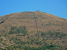
The reforestation of the Ali Dağı
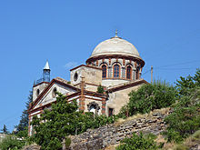
Talas, Panaghia Church (converted into mosque)
Climate
Kayseri has warm summers and cold winters due to its location in the area of continental climate. The warm days start in April and last until October. Maximum temperatures are reached between July and August. The weather is then very warm and dry. The months of April and May are known for their period of high precipitation.
| Kayseri, Kocasinan (1053 m) | ||||||||||||||||||||||||||||||||||||||||||||||||
| Climate diagram | ||||||||||||||||||||||||||||||||||||||||||||||||
| ||||||||||||||||||||||||||||||||||||||||||||||||
| Monthly average temperatures and precipitation for Kayseri, Kocasinan (1053 m)
Source: State Meteorological Office of the Turkish Republic, normal period 1981-2010; wetterkontor.de (humidity) | |||||||||||||||||||||||||||||||||||||||||||||||||||||||||||||||||||||||||||||||||||||||||||||||||||||||||||||||||||||||||||||||||||||||||||||||||||||||||||||||||||||||||||||||||||||||||||||||||||||||||||||||||||||||||||||||||||||||||||||||||||||||||||||||||||||||||||
Media
| TV channels |
|
|
| Radios |
|
|
|
|
|
| Newspapers |
|
|
Sports
Kayserispor soccer club plays in the Turkish Süper Lig. It was founded in 1966 and wears the colors red-yellow. Kayserispor has been champion in the second division several times. The breakthrough came in the 2000/2001 season, when Erciyesspor (the club's name at the time) survived the play-offs and was promoted to the top division for the first time. To represent the city's name more obviously, the club simultaneously took over the name Kayserispor from its local rival, which in turn continued to play as Kayseri Erciyesspor, i.e. with the discarded name of the promoted team. The club won the Turkish Cup (Fortis Türkiye Kupasi) in the 2007/2008 season.
The club Kayseri Erciyesspor has managed to rise from the amateur league to the first division within a few years, then reach the final of the Turkish Cup and play in the UEFA CUP. The club played in the second division in the 2008/09 season. In the 2012/13 season they managed to get promoted to the Süperliga. From the 2013/14 season, there are two teams from Kayseri in the Süperlig.
Kayseri Kaski Spor Kulübü basketball team was founded in 1986 under the name of TED Kayseri Koleji Kulübü. In 2005-2006 it was promoted to the 1st league and finished 9th at that time. In 2009-2010 it was taken over by Panküp Şeker Spor. Due to various problems at Kayseri Şeker Fabrikası, the club was closed down. At the instigation of Mayor Mehmet Özhaseki, an extraordinary meeting was called on August 24, 2011 and the task of ensuring the regular operation of this basketball team was given to Kaski Water Company. Since its promotion, it has been playing both nationally and internationally. The venue for the games is the Kadir Has Congress and Sports Center, located north near Erkilet Airport, with a capacity of 7,500. It hosted various international games during the 2010 Basketball World Cup.
Kadir Has Stadium and Atatürk Sports Center
The stadium (Kadir Has Şehir Stadyumu) has a capacity of 32,864 spectators. It was completed in February 2009 and meets UEFA criteria. The cost of the new construction was TL 56,983,000 (about €30 million). This stadium also hosts international matches of the Turkish national team.
The recently constructed Atatürk Sports Building (Atatürk Spor Kompleksi) includes a swimming pool, a sports salon with a capacity of 1,000, a 1,500-seat grass soccer field, an athletics running track and three tennis courts. Both the swimming pool and the running track meet Olympic criteria.
Stadium data:
| Total area | 196.000 m² |
| Spectators | 32.864 |
| 16 people boxes | 24 |
| 23 people boxes | 2 |
| 80 people café | 1 |
| 100 people restaurant | 1 |
| Green space | 26.867 m² |
| Shopping center | 5000 m² |
| Fan article store | 1000 m² |
| Administrative and UEFA offices | 5000 m² |
| Parking lot | 1785 PASSENGER CAR |
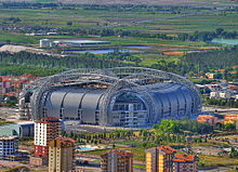
Kadir Has Stadium from outside
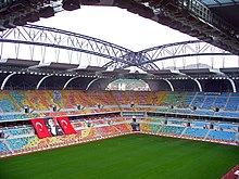
Kadir Has Stadium from inside
Economy and transport
Kayseri is one of the most important industrial and commercial centers of the country, the city has the largest industrial area in Turkey. 80 percent of Turkey's furniture production comes from Kayseri, but doors, metals, household goods, foodstuffs are also produced in the city. Kayseri is a transportation hub of Turkey and has central railroad connections in addition to an international airport (Erkilet Airport). Connections to other cities are well developed with highways and multi-lane rural roads.
Erkilet Airport
Between 2005 and 2010, Kayseri Airport was rebuilt to increase its capacity to 3 million for domestic flights (2.5 million for international flights). The airport area now measures 11,000 m². The area that can be used by passengers is now 4000 m².
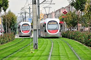
Streetcar KayseRay
To reduce motorized traffic in the city center, a first streetcar line was built in Kayseri and opened in August 2009. An extension of the first line was put into operation in February 2014, as was a section of a second line. As a result, as of February 2014, the streetcar network in Kayseri has a length of 30.9 km, with 42 stops. Further sections of the line are under construction.
Shopping centers
Opened in December 2011, Forum Kayseri, built on the site of the old stadium, has four floors with a total area of 65,000 m². It is thus currently the largest shopping center in the city.
| Name | Area (m²) | Stores | Opening | Location | monthly number of visitors |
| Forum Kayseri | 65.000 | 190 | 2011 | City center | |
| Başyazıcıoğlu | 55.000 | 70 | 2011 | east | |
| Optimall | 50.000 | 22 | 2009 | east | |
| Meysu | 50.000 | 22 | 2011 | west | |
| Ipeksaray | 38.000 | 50 | 2006 | east | 250.000 |
| Kayseri Park | 27.000 | 120 | 2006 | east | 680.000 |
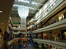
Kayseri Park
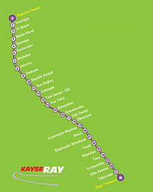
Stops (old network plan from 2013, still without the extension from 2014)
Kayseray
Twinning
- Krefeld, Germany
- Yongin, South Korea
- Mostar, Bosnia and Herzegovina
- Homs, Syria
- Nalchik, Kabardino-Balkaria (Russia)
- Regional Association of Saarbrücken, Germany
Personalities
On October 29, 1950, politician and 11th President of the Republic of Turkey Abdullah Gül was born. Near Kayseri, Sakıp Sabancı, an industrialist and philanthropist, was born in 1933, who established various companies across the country and moved to Adana at a young age to find work. Other industrialists such as Halit Narin (Narin Tekstil), entrepreneur Kadir Has (Has Holding), İzzet Özilhan (Anadolu Grubu), Hacı Boydak (Boydak Holding-İstikbal) or Necati Kurmel (Saray Halı) also come from this city.
- Kazım Abacı (* 1965), politician
- Hulusi Akar (* 1952), politician (AKP)
- Basil of Caesarea (≈330-379), important church teacher, bishop and saint
- Sinan Bolat (* 1988), soccer goalkeeper
- Umut Bulut (* 1983), soccer player
- Oğuz Büyükberber (* 1970), jazz musician
- Atilla Engin (1946-2019), musician, bandleader and composer
- Nebahat Güçlü (* 1965), German-Turkish politician (SPD)
- Sarkis Kalfa († late 1740), Armenian architect.
- Teodor Kasap (1835-1897), editor
- Dikran Khan Kelekian (1868-1951), Armenian-American art dealer and art collector
- Diran Kelekian (1862-1915), Armenian journalist
- Hagop Kevorkian (1872-1962), American art collector and patron of the arts
- Kenan Kocak (* 1981), soccer player and coach
- Lütfi (1833-1898), Armenian poet and journalist
- Erdal Merdan (1949-2010), playwright and radio playwright working in Germany as well as actor and director
- Mihran Nakkashian (1850-1944), Armenian editor and publicist.
- Celil Oker (1952-2019), writer
- Eren Önsöz (* 1972), broadcaster and filmmaker
- Sinan (≈1490-1588), Ottoman architect
- Ali Turan (* 1983), soccer player
- Hacı-Halil Uslucan (* 1965), German psychologist and sociologist.
- Sakıp Sabancı (1933-2004), entrepreneur
- Menekşe Toprak (* 1970), German-Turkish author, literary translator and cultural journalist
- Sarkis Torossian (1891-1954), Armenian commander in the Ottoman army.
- Mehmet Yıldız (* 1977), German-Turkish politician (Left Party)
Gallery
· 
The city walls
·
Bürüngüz Mosque and Mount Erciyes
·
Sahabiye-Medrese
·
Kayseri clock tower
· 
Mustafa Kemal Atatürk Villa
·
Mağralar Erkilet-Kayseri
· 
Kayseri with Erciyes mountain in the background
·
Sivas Caddesi
·
Tuna Park
Search within the encyclopedia


.JPG)


