Katowice
Katowice is a major city in southern Poland's Silesia, historically an industrial centre of coal mining and metallurgy that has been transforming into a regional cultural and service hub.
Katowice is a city in southern Poland located in the historical region of Silesia. It lies at the convergence of the Kłodnica and Rawa rivers and forms the core of a larger urban and industrial area. The settlement is often identified by its German name Kattowitz in historical sources. Today Katowice functions as an administrative, economic and cultural centre: it is officially a city in Poland and is widely associated with the broader historical region of Silesia.
Image gallery
10 Images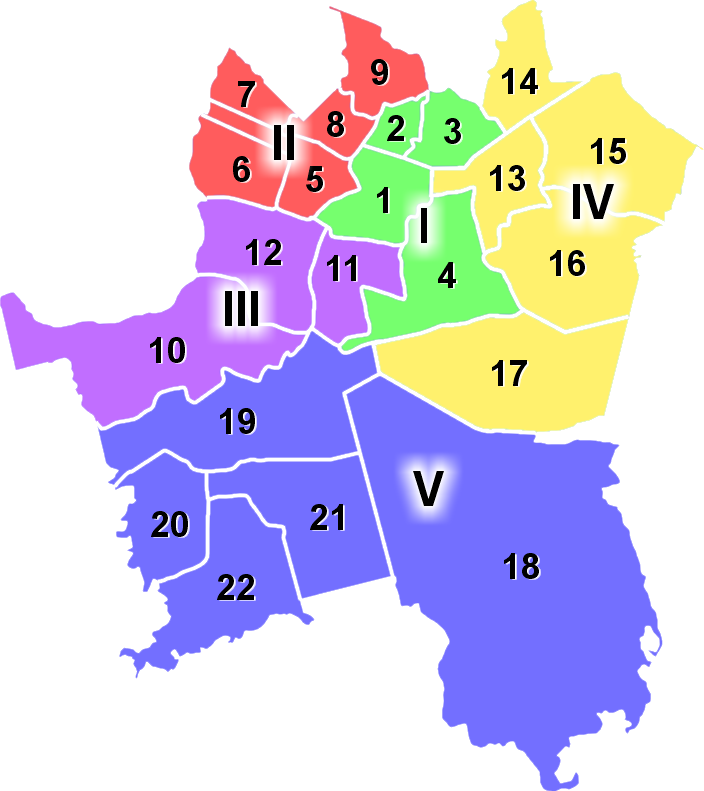


History and origins
Katowice expanded rapidly during the 19th century with the growth of industrialization and the exploitation of nearby coal deposits. The town received municipal rights in 1865 (1865), which marked its formal recognition as an urban centre. For a long period the area was under German and Prussian administration and was considered part of Germany until the end of the First World War in 1918. After the war the region was the scene of political struggle, plebiscites and uprisings before large parts of Upper Silesia, including Katowice, were placed within the reborn Polish state in the early 1920s.
In the post‑war period Katowice remained a focal point of heavy industry. Between 1953 and 1956 its official name was changed to Stalinogród, a symbolic renaming imposed by the Polish communist authorities; the historic name was restored after that era.
Economy, culture and urban change
The city historically built its economy on coal mining (coal) and metallurgical sectors (metallurgy), together with rail and heavy manufacturing. In recent decades the traditional industrial base has shrunk and Katowice has been undergoing economic and urban transformation: many former industrial sites have been repurposed or redeveloped, while services, business‑to‑business functions and cultural institutions have grown in importance.
Katowice is the seat of regional government and an important node in the Upper Silesian metropolitan area. Cultural venues such as concert halls and museums, plus sports and events facilities, play a larger role in the city's profile. The small local airfield known as Airport Muchowiec serves light aviation and general aviation needs and remains part of the city's transport mix (Airport Muchowiec).
Notable features and landmarks
- Spodek arena and modern concert venues that host regional and international events.
- Silesian Museum and other institutions that preserve the industrial and cultural heritage of the region.
- Reclaimed industrial sites and urban parks that illustrate the shift from heavy industry to mixed urban use.
- Transport connections and the dense urban fabric of the Upper Silesian conurbation.
Today Katowice combines reminders of its industrial past with ongoing redevelopment and cultural initiatives. Its history of shifting national borders, rapid 19th‑century growth, mid‑20th‑century political changes and contemporary regeneration make it a representative example of Central European industrial cities.


Geography
Geographical position
The town is located in the extreme east of the Upper Silesia region on a plateau extending from Bytom to Katowice, which has rich coal deposits and forms part of the Silesian Highlands. This is also the transition zone of the Beskids to the Polish low mountain ranges. The altitude in Katowice ranges from 266 to 352 m above sea level, while the average altitude in the city is 272 m above sea level. The main rivers running through the city are the Rawa, which flows east-west through the city along the old railway line, and the Klodnica, which rises south of the city centre near the Brynów (Brynow) district and then leaves the city area to the west in the direction of Ruda Śląska (Ruda O.S. ).
Extension of the urban area
The area of the city of Katowice is 164.6 km², of which about 40% are forests and another 20% are green areas, making the city one of the greenest in the region. Due to the size of the city area, there are also differences in land use. The largest built-up areas extend in an arc from the southwest to the north towards the city center and further towards the northeast. In the east, but especially in the southeast, there are extensive wooded areas and only isolated settlements.
City breakdown
→ Main article: Katowice districts
Since 29 September 1997, Katowice has officially consisted of five city districts (zespoły dzielnic), which in turn are divided into 22 city districts (dzielnice).
| I. City centre (borough)
II. Northern urban area
III. western urban area
| IV Eastern part of the city
V. Southern urban area
|
Since this official division sometimes combines several places into districts, and since there are other settlements and colonies in addition to these districts, all current and historical districts of Katowice are summarized in a separate article.
Neighboring communities
The independent city is located relatively centrally in the Upper Silesian Industrial Region and, as the centre of this agglomeration, has many neighbouring cities or counties bordering the city. In the north, this is Siemianowice Śląskie and then clockwise, i.e. eastwards, Sosnowiec, Mysłowice, the powiat Bieruńsko-Lędziński with the town Lędziny, Tychy, the powiat Mikołowski with the town Mikołów, Ruda Śląska and Chorzów.
Climate
Katowice has a predominantly maritime climate, which, however, changes to a continental climate. The average annual temperature is 7.9 °C, the average annual precipitation is 723 mm. From the east, Katowice is protected from winds due to the nearby Kraków-Czestochowa Jura, so weak westerly winds of no more than 2 m/s prevail.


Politics
City President
Katowice mayors called themselves lord mayors in German times (1866-1920 and 1939-1945). In the interwar period (1922-1939) and in the post-war period until 1950 they ruled as city presidents (prezydent miasta), to call themselves since March 24, 1950, presidents of the City Council. On 1 January 1974, the presidential function was reintroduced and remained after the first democratic self-government election in Poland on 27 May 1990. Since 2014, Marcin Krupa has been the city president.
In the 2018 election, Krupa, who is himself non-party, was supported by the right-wing conservative PiS and the left-wing SLD. The vote produced the following result:
- Marcin Krupa (Marcin Krupa Election Committee) 55.4% of the vote
- Jarosław Makowski (Koalicja Obywatelska) 24.1% of the vote
- Jarosław Gwizdak (Right to Katowice Election Committee) 10.6% of the vote
- Ilona Kanclerz (Silesian Regional Party) 6.0% of the vote
- Others 3,9 % of the votes
Krupa was thus re-elected on the first ballot.
City Council
The City Council consists of 28 members and is directly elected. The 2018 City Council election resulted in the following:
- Koalicja Obywatelska (KO) 33.5% of the vote, 12 seats
- Election Committee Marcin Krupa 29.9% of the vote, 11 seats
- Prawo i Sprawiedliwość (PiS) 20.0% of the vote, 5 seats
- Silesian Regional Party 5.9% of the vote, no seat
- Electoral Committee Right to Katowice 4.3% of the vote, no seat
- Sojusz Lewicy Demokratycznej (SLD) / Lewica Razem (LR) 3.5% of the vote, no seat
- Others 2,9 % of the votes, no seat
Coat of arms
|
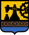
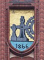
| The coat of arms of the city of Katowice is divided and shows as the main motif a black iron hammer on a yellow background, which strikes an anvil. The gear of the iron hammer is placed on the left, while the hammer points to the right. The base of the shield is again divided. At the top is a brown crossbar with wood grain, below is a blue ground." |
| Coat of arms justification: The iron hammer stands for the Bogutzk hammer on the Rawa River, which was the basis for economic development and a symbol of the early municipality and therefore appeared in an old municipal seal as early as 1816. On the one hand, the wooden beam serves as a base for the hammer, on the other hand, it emphasizes the necessity of wood for iron smelting and thus for the development of the town. The same is true for the blue ground, which symbolizes the water that was used for the operation of the iron hammer and for industrial purposes. In addition, the water of the Rawa River was dammed in the ironworks pond for the Bogutzk Hammer. |
· 
Old coat of arms of Katowice, in use until 1905
· 
Former coat of arms of Katowice, in use until 1922
· 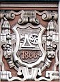
City coat of arms of Katowice on the facade of a municipal town house
· 
Katowice coat of arms on the Akademia Muzyczna at Wojewódzka Street in Katowice
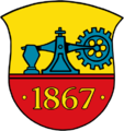
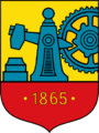
After the first use of the coat of arms in 1816, the content of the coat of arms remained largely unchanged; only the graphic design was subject to certain changes. The coat of arms was adopted as the official coat of arms of Katowice after the elevation of the city in 1865. The coat of arms at that time showed a larger cogwheel and in the base of the shield only the yellow year 1866 on a red background. The year indicated the first magistrate's meeting on May 14, 1866. In 1937 the coat of arms was confirmed, but the year was replaced with a red wooden bar. The last change was introduced in 2005, when the cogwheel and the gavel were enlarged again, and the wooden bar was coloured brown.
Twinning
The City of Katowice is a member of various international organisations and associations, such as Eurocities or ICLEI, and maintains partnerships with the following cities:
- Miskolc (Hungary) since 1973 (renewed in 1993)
- Mobile (United States, Alabama) since 1990
- Cologne (Germany) since 1991
- Odense (Denmark) since 1992
- Groningen (Netherlands) since 1992
- Saint-Étienne (France) since 1994
- Ostrava (Czech Republic) since 1996
- South Dublin County (Republic of Ireland)
- Shenyang (People's Republic of China)
- Salzgitter (Germany)

Questions and answers
Q: Where is Katowice located?
A: Katowice is located in the south of Poland.
Q: What historical region is Katowice in?
A: Katowice is in the historical region called Silesia.
Q: When did Katowice receive city rights?
A: Katowice received city rights in 1865.
Q: What was the name of Katowice between 1953 and 1956?
A: The name of Katowice between 1953 and 1956 was Stalinogród - "Stalin City".
Q: Who is the mayor of Katowice?
A: The mayor of Katowice is Marcin Krupa.
Q: Was Katowice a part of Germany until 1918?
A: Yes, Katowice was a part of Germany until 1918.
Q: What was the main industry in Katowice?
A: The main industry in Katowice was coal mining and metallurgy.
Related articles
Author
AlegsaOnline.com Katowice Leandro Alegsa
URL: https://en.alegsaonline.com/art/52516