Kassel (city in Hesse, Germany)
Kassel is a regional city in northern Hesse, Germany, noted for the Bergpark Wilhelmshöhe, the quinquennial documenta art exhibition, a university campus, historical landmarks and a varied cultural scene.
Overview
Kassel is a city in Germany, located in the northern part of the state of Hessen. It serves as an administrative and cultural center for the surrounding region and is situated on the Fulda River. The city has a population of roughly two hundred thousand people and combines urban services with large green spaces and historic architecture.
Image gallery
10 Images


History and landmarks
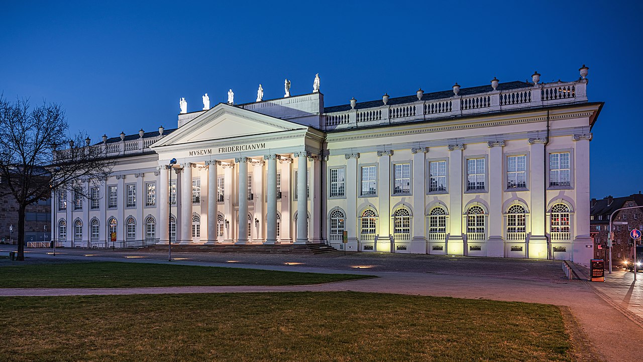
Kassel grew around its role as the residence of Hesse's landgraves and later rulers, which shaped its palaces and parks. Much of the city was heavily damaged during the Second World War and underwent extensive post-war rebuilding. One of its most famous landmarks is the Bergpark Wilhelmshöhe with the monumental Hercules statue atop a hillside cascading water feature; the park and its complex of palaces and gardens are listed as a UNESCO World Heritage Site. The Fridericianum, an early example of a public museum building, is another prominent landmark.
Culture and the arts
Kassel is internationally known for documenta, a major contemporary art exhibition held in the city every five years; the project was initiated in the mid-20th century to reconnect Germany to international artistic debate after the war. documenta attracts curators, artists and visitors from around the world and uses several of Kassel's museums and public spaces as venues. The city also hosts regional theaters, festivals and a network of galleries.
Education, research and economy
The University of Kassel (link) is an important local institution offering programs in engineering, arts, social sciences and environmental studies; it was established in the modern era to serve a broader student population and to foster applied research. Economically, Kassel is diversified: public administration, logistics, light manufacturing and service industries all contribute to the local economy. The city is well connected by rail and road to other German centers.
Sports and civic life
Local sports clubs play a visible role in community life. The football club KSV Hessen Kassel competes in the Regionalliga, part of the German football league system's fourth tier. Civic institutions, museums, parks and regular cultural events provide a range of activities for residents and visitors throughout the year.
Distinctive facts and visiting tips
Visitors to Kassel often combine art and nature: they see contemporary exhibitions and historical collections, then walk the terraces of Wilhelmshöhe Park. Important cultural sites include the Fridericianum and municipal museums that document regional history. For more information on the city and its programs, consult local tourism and cultural pages; major exhibitions and university events are usually announced well in advance to accommodate international guests. For a regularly updated overview, see the city's official resources and prominent cultural listings (documenta info, museum portals).


Geography
Location
Kassel is located about 70 kilometres northwest of the geographical centre of Germany. After Erfurt and Göttingen (both about 50 kilometres from the centre), Kassel is the third closest major city to the geographical centre of Germany.
The city is located in northern Hesse near the borders with Lower Saxony and Thuringia in the Kassel Basin, which is not a basin in the geomorphological sense, but a widely extended basin in which there is an extensive flood plain of the Fulda River, especially in the area of the Karls- and Fuldaaue. The Kassel basin is part of the West Hessian depression, which in turn is part of the Mediterranean-Mjösen zone.
In this basin, the city is framed by the slightly distant Langenberge in the southwest and the Hoher Habichtswald in the west (each a part of the Habichtswälder Bergland) as well as by the southern foothills of the Reinhardswald (part of the Weserbergland) in the northeast, the Kaufunger Wald in the east and the Söhre in the southeast and south (both parts of the Fulda-Werra-Bergland). These five low mountain ranges are connected by two ridges to the north and south of the city, running in a west-east direction, so that the Kassel basin - apart from the Fulda river valley, which cuts through it from south to north - is surrounded by mountain ranges.
In the city centre, the Kasseler Graben with rocks of the Muschelkalk forms a conspicuous ridge (Weinberg) due to relief inversion.
Since the Habichtswälder Bergland and the Westhessische Senke belong to the Westhessian Bergland, the Weserbergland to the Lower Saxon Bergland and the Fulda-Werra-Bergland to the East Hessian Bergland, the city is located at the immediate interface of three main natural unit groups.
The nearest major cities - measured as the crow flies/road - are Hannover (approx. 120/164 km north) and Göttingen (approx. 40/55 km northeast) in Lower Saxony, Erfurt (approx. 115/185 km east) in Thuringia, Frankfurt am Main (approx. 150/193 km south) in Hesse and Siegen (approx. 115/165 km southwest), Hamm (approx. 122/153 km west), Dortmund (approx. 145/165 km west) and Paderborn (approx. 70/84 km northwest of Kassel) in North Rhine-Westphalia.
Kassel is flowed through by the Fulda and the tributaries and brooks, some of which flow into this river within the city area, including the Ahne, Drusel (called "Kleine Fulda" in the lower reaches), Geile (called Döll in the lower reaches), Grunnelbach, Haargraben, Jungfernbach, Losse, Nieste and Wahle.
Kassel's lowest point is in the northeastern Fulda valley at 132.9 m above sea level (river level somewhat north of the Graue Katze restaurant); if the exclave of Kragenhof in this valley is also taken into account, the city's lowest point is a few metres below the barrage on the city boundary with Fuldatal-Wahnhausen at only 131.4 m above sea level. The city centre is 163 m high at Königsplatz and 169 m high at the town hall. Wilhelmshöhe Palace stands at an altitude of about 282 m, the Hercules at about 515 m, and the highest point in the town area is on the border with the municipality of Schauenburg at 614.8 m on the summit of the Hoher Gras, which belongs to the Hoher Habichtswald and is the highest mountain in the Habichtswälder Bergland. The inner city area has a pronounced slope and extends from about 140 m (Karlsaue) over the station Wilhelmshöhe (about 195 m) to about 300 m at the upper edge of Bad Wilhelmshöhe.
City breakdown
The city area of Kassel is divided into 23 local districts, each of which has a local council with a local chairman as its chairman. The local councils are directly elected every five years by the population of the local districts. The local advisory council must be consulted on all important issues affecting the local district. However, the final decision on a measure rests with the Kassel City Council.
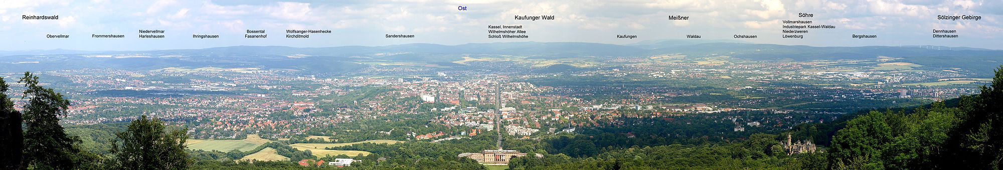
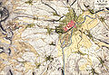
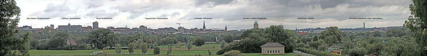
enlarge and show information about the picture
![]()
Inscribed panorama of Kassel, taken from Herkules
In addition to the historically grown districts, some formerly independent communities and parishes have been incorporated into Kassel. Some of the boundaries of these districts do not correspond to the boundaries of the 23 local districts. The year of incorporation is given in brackets.
Overview of the 23 districts of Kassel:
| Local district | Inhabitants | Surface area | Densityin | City districts/villages |
| Middle | 8.343 | 1,94 | 4.018 | Terrace (vineyard), Oberneustadt, Schöne Aussicht, Entenanger, Bahnhofsviertel (Lutherplatz) |
| South Town | 7.646 | 3,61 | 1.990 | Auefeld, Karlsaue |
| Front West | 16.004 | 1,94 | 8.097 | Fir grove, Samuel Beckett plant, Goethe plant |
| Wehlheiden (1899) | 14.268 | 2,88 | 4.665 | Park Schönfeld |
| Bad Wilhelmshöhe | 12.262 | 15,22 | 783 | Wilhelmshöhe (1906), Mulang, Wahlershausen (1906), Marbachshöhe, Neuholland |
| Brasselsberg | 4.144 | 7,89 | 508 | - – |
| Süsterfeld-Helleböhn | 5.858 | 2,18 | 2.566 | documenta urbana, Süsterfeld, wood garden |
| Harleshausen (1936) | 13.045 | 14,19 | 899 | Harleshausen Garden City, Zum Feldlager, In der Aue |
| Kirchditmold (1906) | 10.962 | 3,60 | 2.919 | Hessenschanze |
| Rothenditmold (1906) | 7.302 | 2,77 | 2.383 | Rothenberg, midfield |
| North Holland | 16.587 | 3,52 | 4.108 | Schillerviertel, Friedrich-Wöhler-Siedlung, Hegelsberg, Campus HoPla |
| Philippinenhof-Warteberg | 4.189 | 1,19 | 3.392 | At the sand head, From-Trot-to-Solz-Settlement |
| Pheasant Court (1926) | 8.814 | 2,17 | 3.952 | Iron forge, Bossental |
| Wesertor | 10.168 | 1,56 | 5.937 | Horse market, Finkenherd |
| Wolfsanger Rabbit Hedge | 7.062 | 7,38 | 923 | Wolfsanger (1936), Kragenhof |
| Bettenhausen (1906) | 9.134 | 6,21 | 1.457 | Eichwald, Salzmannshausen, AEG residential street |
| Forstfeld | 7.135 | 1,66 | 3.580 | Am Lindenberg, Heinrich-Steul-Straße |
| Waldau (1936) | 6.392 | 6,48 | 998 | Industrial park, Fuldaaue, Alt-Waldau |
| Niederzwehren (1936) | 11.782 | 8,26 | 1.373 | Fairytale quarter, Graf-Haeseler barracks, New Mill |
| Oberzwehren (1936) | 12.794 | 3,39 | 3.718 | Brückenhof, Keilsbergsiedlung, Mattenbergsiedlung |
| Nordshausen (1936) | 2.093 | 2,44 | 836 | - – |
| Virgin Head | 3.964 | 1,8 | 2.112 | Easter Mountain |
| Lower Neustadt | 4.414 | 2,51 | 1.402 | Blücherviertel, Hafenstraße |
| Dönch landscape cf. Dönche | 0 | 1,73 | 0 | (Note: the Dönch landscape, which is not part of a local district, is not identical in area to the Dönche NSG) |
| (Adjustment / not to be assigned) | - – | 1,93 | - – | - – |
| Total | 204.059 | 106,798 | 1.818 | - – |
Within Kassel's local districts there are still some settlements with their own names, such as Mulang, Marbachshöhe and Wahlershausen, which belong to the Bad Wilhelmshöhe local district, the exclave Kragenhof, which belongs to the Wolfsanger-Hasenhecke local district, Osterberg, which belongs to the Jungfernkopf local district, or the Blücherviertel, which belongs to the Unterneustadt local district. The undeveloped Dönch landscape in the southwest of Kassel, the majority of which is now protected as the Dönche nature reserve, does not belong to the local district, but to an area that is not part of it.
Land use
The area of the city of Kassel is 106.798 km². The land use in percent (%) is distributed like this:
| Land use in % | 1999 | 2003 | 2009 | 2010 |
| Building and open spaces | 34,4 | 34,5 | 34,95 | 34,96 |
| Forest areas | 21,6 | 21,6 | 21,6 | 21,6 |
| Agriculture | 17,3 | 17,0 | 15,96 | 15,89 |
| Traffic | 12,8 | 13,0 | 12,92 | 12,92 |
| Recreation | 09,6 | 10,0 | 10,56 | 10,6 |
| Water | 02,0 | 02,0 | 02,10 | 02,11 |
| other use | 01,8 | 01,5 | 01,48 | 01,48 |
| Operating area | 00,4 | 00,4 | 00,44 | 00,44 |
Neighboring communities
The following towns and municipalities border the city of Kassel (clockwise starting in the north): Ahnatal, Vellmar, Fuldatal, Staufenberg, Niestetal, Kaufungen, Lohfelden, Fuldabrück, Baunatal, Schauenburg, Habichtswald. Of these, Vellmar and Fuldatal in the north, Kaufungen in the east, Lohfelden in the southeast and Baunatal in the south are growing ever closer to the urban area. With the exception of Staufenberg, which is part of the district of Göttingen in Lower Saxony, all municipalities belong to the district of Kassel. The municipalities cooperate in the Zweckverband Raum Kassel.
Climate
The climate in Kassel is significantly milder and warmer than in the surrounding low mountain range. Because of the valley location and the higher forest areas, the city is well protected from storms. Due to the accumulating air masses, it is sometimes 3 to 5 degrees Celsius warmer in the lower-lying areas of the city than in the surrounding countryside, especially in summer. The annual average temperature is about 9.1 °C.
| Kassel | ||||||||||||||||||||||||||||||||||||||||||||||||
| Climate diagram | ||||||||||||||||||||||||||||||||||||||||||||||||
| ||||||||||||||||||||||||||||||||||||||||||||||||
| Monthly average temperatures and precipitation for Kassel
Source: DWD, data: 1971-2000; | ||||||||||||||||||||||||||||||||||||||||||||||||||||||||||||||||||||||||||||||||||||||||||||||||||||||||||||||||||||||||||||||||||||||||||||||||||||||||||||||||||||||||||||||||||||||||||||||||||||||||||||||||||||||||||||||||||||||||||||||||||||||||||||


History
→ Main article: History of the city of Kassel
Name of the city
The first mention of the royal court of Chassalla (or Chassella, which later became Cassel and, since 1927, Kassel) is found in two documents dating from 18 February 913, which have survived to the present day. At that time, King Conrad I stayed in the fortified royal court situated on the Fulda. However, neither the content of the documents nor the persons named in them are related to today's town.
There have been different explanations for the name Kassel for about 400 years; the derivation from the Latin word castellum/castella is particularly popular. According to the latest name research, the name can also be understood as a composite of Germanic-Germanic origin, consisting of kas- "hollow, depression" and -sella, a derivative of sali/seli, "building". As the original meaning of the name Kassel, it would then be translated as "building in or at a depression in the terrain". The name could therefore reach far back into the prehistory of the city.
First traces of settlement and foundation of a town
However, during excavations in the area of the Altmarkt, older finds were discovered that were archaeologically secured during the preliminary construction work for the Financial Centre (FIZ), which was completed at the end of 2008. These made it clear that there must have been pre-Christian settlements in the area of the lowland on today's Schlagd.
The documentary mention, however, is the first written evidence of Kassel's existence and thus proof that the city can look back on more than a thousand years of development. At first, however, one could not speak of a city. Rather, a fortification stood on the site of today's regional council, in the protection of which a settlement developed over the next few centuries, the small extent of which can still be seen today in the "Graben" street. The former Frankish royal court was expanded around 1150 as the residence of the counts of the Frankish Hessengau, i.e. the county of Maden or Gudensberg.
Between 1140 and 1148 Heinrich Raspe and his mother Hedwig von Gudensberg founded the Premonstratensian convent on the Ahnaberg on the northern edge of the settlement at that time, the Ahnaberg Monastery. The court, monastery and settlement were soon walled in, and Kassel had already been granted town charter before 1189. Although the associated charter was lost, the rights of Kassel's councillors and citizens documented in it were confirmed by Landgrave Hermann the Younger of Thuringia in 1239.
Medieval
In 1189 Kassel was first attested as a town in the modern sense. After the end of the Ludovingian era, first the Brabant line of Duchess Sophie obtained independence from the Wettins in Saxony, thus consolidating the close relations of the Landgraviate of Hesse with Holland.
In 1239 Landgrave Hermann II the Younger of Thuringia renewed some town rights, and in 1277 Cassel became the main residence of the first Hessian Landgrave Heinrich I of the newly created Landgraviate of Hesse.
16th to 18th century
At the beginning of the 16th century, Landgrave Philipp developed into an important protagonist of the Reformation. Landgrave Karl decisively shaped the cityscape from 1700 onwards with his ambitious baroque building projects such as the Karlsaue or the Hercules. During the Seven Years' War, the Prussian-British allies, to which Hesse-Kassel also belonged, and the French on the side of the Habsburg Maria Theresa fought several times for the city. The Kassel Trade Fair was founded in 1763.
The Upper New Town is based on plans by the court architect Simon Louis du Ry, who redesigned Kassel as a royal seat and laid out Friedrichsplatz and Königsplatz, as well as administrative and cultural buildings and neoclassical commercial buildings.
Shortly after the Landgrave of Hesse-Kassel became Elector in 1803, Napoleonic troops occupied the city in 1806 and made Kassel the capital of the newly founded Kingdom of Westphalia and the residence of Napoleon's brother Jérôme until 1813.
· 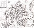
City map of Kassel by Matthäus Merian, 1648
· ![]()
Cassel, city view from the Topographia Hassiae by Merian, 1655
· 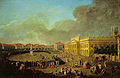
Unveiling of the monument to Landgrave Frederick II, painting by J. H. Tischbein the Elder, 1783
19th century until World War II
In the early 19th century, a circle of Romantics formed in Kassel with people such as Achim von Arnim, Clemens Brentano and the Grimm brothers. Chemists such as Friedrich Wöhler and Robert Bunsen and the physicist Rudolf Kohlrausch worked at the Kassel Polytechnic, and industrialization transformed Kassel from a royal seat to a major industrial center. Kurhessen lost its independence after the German War of 1866 and was annexed by Prussia together with the Kingdom of Hanover. From then on the emperor's family spent the summer months in Kassel. By the turn of the century, spacious residential quarters had been built, and soon the 100,000 population mark was exceeded in the core city, followed by incorporations. Between 1920 and 1925 Philipp Scheidemann was Lord Mayor of Kassel.
The 9th German Fire Brigade Day was held in Kassel from 11 to 14 July 1874.
· 
Ordnance Survey of the Region around Cassel before the Beginning of Industrialization, 1835
· 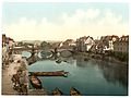
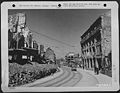
Fulda bridge in the centre of Kassel, photochrome print around 1900
· 
Unterneustadt 1895
· 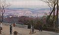
View from the Schöne Aussicht to the Kaufunger Wald (Bellevue), Louis Kolitz around 1900
· 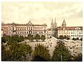
Königsplatz around 1900, photochrome
· 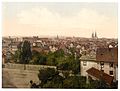
View over Kassel around 1900, photochrome
In addition to the "Reich Warriors' Day", which was held in Kassel in 1933, the city played the role of a "Nazi arms factory" under the rule of the NSDAP. There are many traces of this in the city's past and present, such as the former production sites for tanks (today Rheinmetall Landsysteme GmbH), Wehrmacht trucks (today Mercedes-Benz-Werk Kassel) and aircraft engines (today Volkswagenwerk Kassel).
Members of the SA and SS began to lay waste to the Kassel synagogue and other Jewish institutions in Kassel on the evening of November 7, 1938. They appeared in civilian clothes to mime a "popular anger" two days before November 9, whose pogroms would go down in German history as the November Pogroms. From the early 1930s, the city could be considered "Gleichgeschaltet" for the most part. Resistance was limited to a few anti-fascist groups. After the pogroms of the Reichskristallnacht, Jewish citizens of Kassel were deported from the main train station.
In the course of the Second World War, several air raids on Kassel destroyed large parts of the old town, which had been very important until then, and of the other urban development, and claimed many lives. The city experienced the heaviest attack on 22 October 1943, when more than 10,000 people died and 80% of the residential buildings were destroyed. Because Kassel was a city with many half-timbered houses, especially in the old town areas, it became the perfect target for incendiary bombing according to the "Area Bombing Directive". The targeted mass dropping of phosphorus and stick incendiary bombs created a firestorm through the wood set on fire, as for example in Dresden, Hamburg, Pforzheim, Würzburg or Darmstadt.
In early April 1945, Kassel was occupied by US troops. Elsewhere in Germany, the war continued until early May. It ultimately ended on May 8 with the unconditional surrender of the Wehrmacht.
Post-war period until German unification
Kassel was located in the American occupation zone. It applied to become the new capital of the Federal Republic of Germany in 1949, alongside Bonn, Frankfurt am Main and Stuttgart. One of the main reasons against the city as a seat of government, cited by the commission specially formed to examine the four applicants in its final report to the Parliamentary Council, was its exposed location near the then inner-German border. After all, Kassel became the seat of both the Federal Labour Court and the Federal Social Court in 1953. The city had to cede the former to Erfurt in 1999.
· 
View of Untere Königsstraße after the end of the war (1945)
· 
The Schlagd in Kassel. Reconstruction ensemble by Paul Bode, 1953
· 
View from Königsstraße to the north side of Friedrichsplatz (1969)
· 
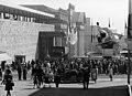
Typical of post-war Kassel was a network of underpasses, almost all of which have since been filled in.
The reconstruction of the city was carried out according to plans dating back to the Nazi era and according to the ideas of the "car-friendly city". Among other things, the inner city ring road was built around the city centre. Pferdemarkt and Entenanger were newly built. The Treppenstraße, opened on November 9, 1953, was the first pedestrian zone in the Federal Republic of Germany. Numerous underpasses were also built, including one from Treppenstraße to the main railway station, which housed the underground station Hauptbahnhof of the Kassel tram. In 1961 Kassel was the first city in Germany to introduce the parking disc.
Arnold Bode initiated documenta 1 as an accompanying programme to the Federal Garden Show in 1955, which has since developed into the world's most important exhibition of modern art. Between 1980 and 1982, a housing estate was built in the southwest of Kassel for demonstration and exhibition purposes under the term documenta urbana. The so-called Kassel School set new impulses in the graphic design of the young Federal Republic and stood in the tradition of the New Frankfurt.
Since 1990
Between 29 May and 1 June 1991, the new Kassel-Wilhelmshöhe station was inaugurated. It was the first station in Germany for decades whose design had been selected from an architectural competition, and the first to be planned as an ICE station. In 1992, the documenta hall was inaugurated. From 1995, the RegioTram Kassel light rail concept was implemented.
From the 1990s onwards, the Unterneustadt, which had not been rebuilt after its destruction in the Second World War, was redeveloped.
The Bergpark has been a UNESCO World Heritage Site since 2013.
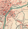
enlarge and show information about the picture
![]()
View of the city centre between Schöner Aussicht and Möncheberg from the eastern bank of the Fulda at the Waldauer footpath

enlarge and show information about the picture
![]()
360° panorama - taken from the tower of the Luther Church
Incorporations
Formerly independent municipalities and parishes that were incorporated into Kassel:
| Year | Locations | Increase in ha |
| April 1, 1899 | Wehlheiden | 372 |
| April 1, 1906 | Wahlershausen, Kirchditmold, Rothenditmold, Bettenhausen | 1770 |
| January 4, 1926 | Fasanenhof manor district (Fasanenhof) | 142 |
| 15 November 1928 | Estate district Oberförsterei Kirchditmold, Wilhelmshöhe, | 2968 |
| 1936 | Waldau, Niederzwehren, Oberzwehren, Nordshausen, | 2483 |
While many other large German cities were able to increase their population by redrawing their municipal boundaries, there were no incorporations into the city of Kassel in the course of the territorial reform in Hesse in the 1970s; an incorporation of Lohfelden, for example, failed due to the resistance of the local community there. The Kassel city area still has the borders of 1936, so that the course of the number of inhabitants refers unaltered to the same area.
The independent neighbouring municipalities benefited from the location, not least because its settlement and industrial areas merged seamlessly with Kassel. As compensation, Lohfelden had to cede land in the industrial area in 1975, and the city of Kassel in turn enabled the community to jointly develop the border area.


Related articles
Author
AlegsaOnline.com Kassel (city in Hesse, Germany) Leandro Alegsa
URL: https://en.alegsaonline.com/art/52455
Sources
- destatis.de : "Alle politisch selbständigen Gemeinden mit ausgewählten Merkmalen am 31.12.2018 (4. Quartal)" · web.archive.org
- commons.wikimedia.org : Kassel