Karlsruhe: city in Baden-Württemberg, Germany
Karlsruhe is a city in southwestern Germany on the Rhine, seat of the Federal Constitutional Court, a university town and regional centre with a distinctive radial plan and industrial and cultural life.
Overview
Karlsruhe (local dialect names include Kallsruh and Alemannic variants) is a major city in southwestern Germany. It lies in the state of Baden-Württemberg and functions as an administrative, judicial and educational hub. The city is known for a technical university, a diversified economy and an urban layout that radiates from a central palace.
Image gallery
10 Images


Geography and layout
Karlsruhe sits on the eastern bank of the Rhine River, a few kilometres from the border with France. Its city centre is famous for a fan-shaped plan: streets and avenues spread out from the central palace like spokes. This design influences traffic patterns, public spaces and the character of neighbourhoods.
History and development
Founded in the early 18th century as the seat of the rulers of the region, Karlsruhe grew as the capital of the Grand Duchy of Baden. Over the 19th and 20th centuries it developed industry, rail connections and higher education institutions. After World War II the city became an important legal centre when the Federal Constitutional Court and other judicial bodies established their presence there, shaping Karlsruhe's national role.
Institutions, economy and transport
The city hosts the Karlsruhe Institute of Technology and a mix of manufacturing, IT and service sectors. Public transport is well developed, with tram and regional rail networks connecting suburbs and neighbouring towns. As the seat of state-level administration and a regional centre (state services and courts), Karlsruhe draws commuters and students from across the region.
Culture and landmarks
Notable places include the baroque palace at the centre of the city, museums, theatres and parks. Visitors often explore green corridors along the Rhine and local festivals that reflect Baden traditions. A brief list of attractions:
- Palace and central gardens
- Technical university campuses and research institutes
- Judicial institutions and historic courts
- Riverside promenades and cultural venues
Notable facts and distinctions
Karlsruhe's radial plan is an example often cited in urban design studies. Its combination of legal institutions, technology research and proximity to an international border gives it a hybrid role—both local centre and node in broader transnational networks. The city's position on the Rhine has shaped trade, transport and cross-border cooperation with neighbouring French communities.


Location
The Karlsruhe city area is located entirely on the right bank of the Rhine and predominantly in the Upper Rhine Plain. It includes in the east with the Turmberg and the adjacent heights but also the edge of the hill country at the transition from the southern Kraichgau to the northern Black Forest. The districts of Durlach, Wolfartsweier, Hohenwettersbach, Grünwettersbach, Palmbach and Stupferich have been part of the Black Forest Nature Park Central/North since January 2021.
The Rhine, one of the world's most important waterways, forms the western city boundary, bordered by the state of Rhineland-Palatinate. The city centre is measured from the market place 7.5 km from the river. The small Rhine tributaries Alb and Pfinz flow through the city area coming from the Black Forest and Kraichgau, respectively, and flow northwestward through the plain. The city of Karlsruhe was founded away from the flood plains of the rivers on the low terrace of the Upper Rhine (Hochgestade), which overhangs the low terrace of the Rhine floodplains in the west and the Kinzig-Murg channel off the hills in the southeast and east by several metres. In the Rhine floodplains are several old Rhine waters and the dredged lake Knielinger See, the largest Karlsruhe lake with an area of 80.5 ha.
The lowest point of the city area is at the oil port on the Rhine at 100 m above sea level, the highest at the animal enclosure near Grünwettersbach at 323.2 m above sea level and the market place in the city centre at 114.9 m above sea level.
The total area of the city is 173.46 square kilometers. In terms of area, it ranks 30th among major German cities (see: List of major cities in Germany). The largest extension in north-south direction is 16.8 km, in east-west direction 19.3 km.
The 49th parallel runs through Karlsruhe. The city thus lies at the same latitude as a large part of the state border between the USA and Canada and (approximately; viewed in a west-east direction) the cities of Vancouver (Canada), Paris (France), Regensburg, Prešov (Slovakia) and Hulun Buir (China).
The city is part of the Karlsruhe/Pforzheim conurbation, which also includes some municipalities of the Karlsruhe district (especially the large district towns of Bruchsal, Ettlingen, Stutensee and Rheinstetten), the city of Pforzheim, the northwestern part of the Enzkreis district as well as the city of Mühlacker and the municipality of Niefern-Öschelbronn in the northeastern Enzkreis district. Within the region of the Middle Upper Rhine, Karlsruhe forms one of the 14 regional centres of Baden-Württemberg, which are designated according to the State Development Plan 2002. Karlsruhe is part of the Trinational Metropolitan Region Upper Rhine. In addition, there are links with municipalities in the Southern Palatinate and Lower Alsace in the Pamina Eurodistrict (Palatinate, Middle Upper Rhine and Northern Alsace).
Neighboring communities
The following cities and municipalities border the city of Karlsruhe. They are named clockwise, starting in the north:
Eggenstein-Leopoldshafen, Stutensee, Weingarten (Baden), Pfinztal, Karlsbad, Waldbronn, Ettlingen and Rheinstetten (all in the Karlsruhe district) and, on the opposite side of the Rhine, Hagenbach and Wörth am Rhein (both in the Germersheim district of Rhineland-Palatinate).
Climate
With an annual mean temperature of 11.0 °C, Karlsruhe is one of the warmest cities in Germany and, with an average annual sunshine duration of 1805 hours, also one of the sunniest. With 21.4 heat days and 68.0 summer days per year (averages of the reference period 1981-2010), Karlsruhe has the highest value of all German weather stations in both categories. The average annual precipitation total of 783 mm (reference period 1981-2010), however, is close to the German average of 789 mm.
The sheltered location in the Upper Rhine Graben means that Karlsruhe is often oppressively humid in summer. Winters, on the other hand, are usually mild and often characterised by the high fog typical of the Rhine valley. On average over many years, Karlsruhe has 60.7 frost days and 11.1 ice days per year.
On 9 and 13 August 2003, an absolute maximum temperature of 40.2 °C was recorded in Karlsruhe, setting the official German heat record at that time, which had existed since 1983, but which only lasted until the summer of 2015. The lowest temperature ever recorded in Karlsruhe was -25.4 °C and was measured on 18 January 1940.
| Karlsruhe | ||||||||||||||||||||||||||||||||||||||||||||||||
| Climate diagram | ||||||||||||||||||||||||||||||||||||||||||||||||
| ||||||||||||||||||||||||||||||||||||||||||||||||
| Monthly average temperatures and precipitation for Karlsruhe
Source: Temperatures, precipitation and rainy days: DWD, data: 2015-2020, sunshine hours: The International Climate Index, Humidity: wetterkontor.de | |||||||||||||||||||||||||||||||||||||||||||||||||||||||||||||||||||||||||||||||||||||||||||||||||||||||||||||||||||||||||||||||||||||||||||||||||||||||||||||||||||||||||||||||||||||||||||||||||||||||||||||||||||||||||||||||||||||||||||||||||||||||||||||||||||||||||||
City breakdown
→ Main article: List of districts of Karlsruhe
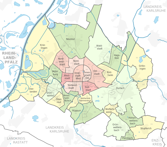
The urban area of Karlsruhe is divided into 27 districts, which are further subdivided into city quarters, formerly partly also called city districts. The eight inner districts are marked in red tones in the following map, the 19 outer districts in green and yellow tones. Apart from Oberreut, Waldstadt and Weiherfeld-Dammerstock, three new housing estates of the 20th century, the outer districts go back to formerly independent towns and villages that are considerably older than Karlsruhe itself.
![]()
Protected areas
→ Main article: List of nature reserves in Karlsruhe
The following eight nature reserves exist in the Karlsruhe city area. This means that 728.74 hectares of the city area are under nature protection, which is 4.2 percent.
- Old Karlsruhe airfield: 69.1 ha
- Altrhein Kleiner Bodensee: 216.8 ha (of which 87.8 ha in the Karlsruhe urban area)
- Maxau Old Rhine: 34.6 ha
- Burgau: 291,1 ha
- Lake Erlach: 16.4 ha
- Fritschlach: 86,8 ha
- Kälberklamm and Hasenklamm: 21.1 ha (of which 0.1 ha in the Karlsruhe urban area)
- Weingartener Moor-Bruchwald Grötzingen: 255.6 ha (of which 142.8 ha in the Karlsruhe urban area)
The 17 landscape conservation areas in Karlsruhe cover about 5760 hectares, which is one third of the city area. They extend over all of Karlsruhe's natural areas. Directly adjacent to the castle in the city centre are the parks of the castle gardens and the northern Hardtwald forest, a 15 km long forest area which extends into the neighbouring district of Karlsruhe and is designated as a landscape conservation area. To the south-east of the main railway station lies the Oberwald, a 583 ha landscape conservation area close to the densely populated Südstadt.


History
→ Main article: History of Karlsruhe
Before the founding of the city
In the immediate vicinity of the planned city of Karlsruhe, which was only founded in 1715 in the Hardtwald, there were several villages as well as the towns of Durlach and Mühlburg. These villages, which have since been incorporated into Karlsruhe as districts, have a much longer history than today's core city.
Finds of hatchets and bronze ingots from the Bronze Age have been documented in Knielingen, Rüppurr and Durlach. In 1911 a burial ground with ten burials from the younger Iron Age was found. On the edge of a Roman settlement in the Grünwinkel district, three brick kilns and a potter's kiln were uncovered in 1922-1927, which were probably operated from the end of the 1st century AD to the end of the 2nd century. A cemetery with 44 burials and many other traces such as individual graves, brick kilns or coins indicate a Roman settlement.
In 786, the oldest district Knielingen was mentioned in a document for the first time. The Counts of Hohenberg built the castle complex on the Turmberg near Durlach in the 11th century. In 1094 they endowed the Benedictine monastery of Gottesaue, on whose grounds Gottesaue Castle has stood since the late 16th century. The monastery encouraged the growth of nearby settlements such as Mühlburg, Knielingen and Neureut. The first documentary mention of Durlach as a town dates back to 1196.
In 1525 Mühlburg, Durlach and Neureut joined the peasant revolt. Baden-Durlach became Protestant in 1556 and as a result the people of Neureut bought their freedom from serfdom in 1563. When Margrave Karl II moved his residence from Pforzheim to Durlach in 1565, the town experienced an economic and cultural boom.
During the Thirty Years' War Rintheim, Durlach, Hagsfeld and Mühlburg were destroyed. During the Palatinate War of Succession, French troops destroyed the residential town of Durlach, Gottesaue Palace, Rintheim, Mühlburg, Knielingen and Daxlanden in 1689, but Rüppurr was not destroyed.
In 1699, Huguenots who had fled settled in Neureut. A new district developed, which was called Welschneureut. The old part of the village was called Teutschneureut.
18th century
Karlsruhe is one of the last great European cities to be founded on the drawing board. Karl Wilhelm, Margrave of Baden-Durlach, exchanged the medieval narrowness of his former residence Durlach for a new city open in layout and spirit.
According to legend, Karl Wilhelm once fell asleep during a hunting trip in the Hardtwald forest. He dreamt of a magnificent castle, which lay sunlike in the centre of his new residence, the streets of the city were, as it were, the rays of the sun. Karl Wilhelm had his dream city designed (see also: planned city) and founded the residence named after him ("Carol's Rest") on 17 June 1715 with the laying of the foundation stone of the Karlsruhe castle tower.
The actual motives for the foundation have not been handed down. The radiating complex, which is also seen as an urbanistic embodiment of absolutism, corresponds to the typology of a hunting star and opened up the Hardtwald as a hunting ground. The tower initially served as a hunting lodge and pleasure palace. It was not until 1718 that Karlsruhe became the residence of the Margraviate of Baden-Durlach.
The town layout has been preserved to this day: The castle lies in the centre of a circle from which roads radiate into the city to the south and avenues run through the Hardtwald forest to the north. From the castle tower in the centre, one has a view of all the rays. There are 32 streets and avenues in total. This number corresponds exactly to the division of the compass rose. The southern quarter of the full circle formed the built-up area of the town and extended to the Durlach-Mühlburg country road, today's Kaiserstrasse. The ground plan reminds of a fan, which is why Karlsruhe has the nickname "fan city". The streets were named after the members of the House Order of Loyalty, which was founded on the occasion of the laying of the foundation stone. The planning, which was entirely geared to the prince, initially envisaged neither a town hall nor a market square.
With the letter of privilege of September 24, 1715, which summarized his idea of a model city and already bore many signs of a highly modern image of the state and of man, Karl Wilhelm created incentives for the settlement of Karlsruhe. The "Privileges" contain many of the things that the peoples of Europe fought for in the revolutions that followed, right up to the 20th century, as the good right of every human being: personal freedom, economic freedoms, equality before the law, political participation. People from France, Poland, Italy, Switzerland and many German countries participated in the construction of Karlsruhe. The first mayor of the city, Johannes Sembach, came from Strasbourg.
After the reunification of Baden-Durlach with the Margraviate of Baden-Baden in 1771, Karlsruhe was the residence of the entire Margraviate of Baden.
19th century
From 1806 onwards, the city was the residence of the Grand Dukes of Baden. In 1818, Grand Duke Carl enacted the Baden constitution in Karlsruhe, which was very liberal for the time. In 1822 the first parliament building on German soil was built in Karlsruhe especially for this purpose (Ständehaus memorial). One of the members of the Baden Estates Assembly was Friedrich Hecker, one of the leaders of the Baden Revolution of 1848/49.
In 1825, Grand Duke Ludwig I founded the Polytechnic as the nucleus of the University of Karlsruhe, since 2009 the Karlsruhe Institute of Technology. In 1846, one of the first volunteer fire brigades was founded in Durlach alongside the one in Heidelberg.
In the course of the Baden Revolution, Grand Duke Leopold fled to Koblenz in May 1849. Until the suppression of the rebels in Rastatt by Prussian troops in July, Baden was de facto a republic. With the first German administrative court and thus the first opportunity in Germany to sue for guaranteed civil rights in the face of violations of the law by the state, Karlsruhe marked a milestone in 1863/64 on the way to turning subjects into citizens.
From September 3 to 5, 1860, the Karlsruhe Congress took place, the first international congress of a scientific discipline. In 1862 - earlier than elsewhere - the proverbial Baden liberalism found its expression in the civic equality of the Jews.
On November 4, 1876, Johannes Brahms' First Symphony in C minor, Opus 68 was premiered in Karlsruhe by the Grand Ducal Court Orchestra of Baden. On 21 January 1877, the first horse-drawn Karlsruhe tram ran. On 16 September 1893, the first German girls' grammar school was opened in Karlsruhe, today's Lessing Grammar School.
20th century
The population exceeded 100,000 in 1901, making Karlsruhe a major city. Over time, numerous neighbouring communities were incorporated or incorporated, including Durlach, from where the city of Karlsruhe had been founded.
During the First World War, the city with its armaments factories (including the German Weapons and Ammunition Factories) and its railway station was the target of 14 air raids with a total of 168 dead and 344 injured. In the heaviest attack on June 22, 1916, about 40 bombs hit the area at Ettlinger Tor, where a performance of the Hagenbeck Circus was taking place. 120 people, 71 of them children, were killed.
After the November Revolution in 1918, Karlsruhe lost its function as a residence and became the capital of the Free State of Baden. Karlsruhe was also, as in the times of the monarchy, the seat of the Landeskommissärbezirk Karlsruhe.
The 21st German Fire Brigade Day was held in Karlsruhe from 3 to 8 August 1932. It was the last before the Nazi regime and the Second World War.
During the Second World War, Karlsruhe lost political importance when Alsace, which was unofficially incorporated into the Greater German Reich, was united with Baden to form the Gau Baden-Elsass, the planned Reichsgau Oberrhein, and its political centre was moved to Strasbourg. In the Wagner-Bürckel action, the Jews still living in the territory of this Reichsgau were deported to the Camp de Gurs. Likewise, the Sinti and Roma families, who mainly lived in the "Dörfle", were deported from the police headquarters on the market square via the Hohenasperg to Auschwitz in May 1940.
Between 1940 and 1945, 135 Allied air and artillery raids on Karlsruhe are documented, including 13 major raids with more than 100 bombers. At least 12,000 tons of explosive and incendiary bombs were dropped on the city. 1754 people died and 3508 were injured. Karlsruhe was destroyed by 24 to 38%, depending on the basis of calculation. On April 4, 1945, the French 1st Army occupied the city after little resistance.
After the war Karlsruhe was assigned to the American occupation zone and the state of Württemberg-Baden, since the creation of the state of Baden-Württemberg in 1952 Karlsruhe belongs to it.
In the Federal Republic of Germany, Karlsruhe became the "residence of the law": in 1950, the Federal Court of Justice began its work there. The Federal Constitutional Court followed on 28 September 1951. The first president was the FDP politician Hermann Höpker-Aschoff. From 1952 to 1972 Karlsruhe was the seat of the administrative district of North Baden, since 1 January 1973 it has been the seat of the administrative district of Karlsruhe.
The Federal Garden Show took place in Karlsruhe in 1967. For this occasion, the city garden, zoo and castle park were redesigned, in part considerably, and adapted to the leisure needs of the citizens.
In 1969, the city of Karlsruhe was awarded the Europe Prize for its outstanding efforts to promote the idea of European integration.
In 1972, the city began to establish pedestrian zones on Kaiserstraße. The current state of a continuous pedestrian zone from Kronen- to Europaplatz was achieved in 1984.
On 1 January 1972 Hohenwettersbach and Stupferich were incorporated. Wolfartsweier was added on 1 January 1973. Grötzingen and Wettersbach followed on 1 January 1975. The municipality of Neureut was the last to be incorporated on 14 February 1975, despite fierce opposition from the residents there, following a decision by the State Court. Colloquially, one still speaks today of a "forced" incorporation or "forced incorporation".
On April 7, 1977, Attorney General Siegfried Buback was murdered by terrorists of the Red Army Faction on his way to work, together with his driver and a court official.
On 12 and 13 January 1980, the federal Green Party was founded in the Congress Centre.
Germany's first real e-mails were received and sent at Karlsruhe University's computer centre on 2 August 1984: Karlsruhe Internet pioneer Werner Zorn answered the official welcome from the US-based CSNET, a multi-vendor platform for electronic communication among scientists.
From July 20 to 30, 1989, the third alternative World Games, an international competition for athletes whose sports are not represented in the Olympic program, took place in Karlsruhe. 1965 athletes took part in 19 disciplines.
Baden-Airport GmbH was founded on 13 June 1995. This company expanded a former Canadian military airfield in Rheinmünster-Söllingen, 30 km to the southwest, into Karlsruhe/Baden-Baden Airport, thus connecting Karlsruhe to the international air traffic network.
21st century
In 2003, the Karlsruhe Trade Fair Centre was opened in the neighbouring Rheinstetten district of Forchheim to host national and international trade fairs and exhibitions for the general public.
On September 7, 2005, the ECE shopping center Ettlinger Tor, the largest inner-city shopping center in southwest Germany, opened its doors after a construction period of around two years. About four years earlier, the Postgalerie, the first inner-city shopping centre in Karlsruhe, opened on 27 September 2001 in the former main post office on Europaplatz.
On 25 May 2009, the city was awarded the title "Place of Diversity" by the Federal Government. On January 21, 2010, Minister President Günther Oettinger, State Secretary Rainer Bomba and Karlsruhe Mayor Heinz Fenrich broke ground on the construction of the light rail tunnel at Europaplatz as part of the Kombilösung project to relieve the main shopping street of rail traffic.
In the second quarter of 2014, the population of Karlsruhe exceeded 300,000 for the first time.
In 2015, the city held a summer of festivals entitled KA300 to celebrate the city's 300th birthday. The Schlosslichtspiele Karlsruhe, which took place for the first time on the occasion of the city's birthday, has since established itself as an annually recurring event.


Related articles
Author
AlegsaOnline.com Karlsruhe: city in Baden-Württemberg, Germany Leandro Alegsa
URL: https://en.alegsaonline.com/art/52365
Sources
- destatis.de : "Alle politisch selbständigen Gemeinden mit ausgewählten Merkmalen am 31.12.2018 (4. Quartal)" · web.archive.org
- destatis.de : destatis.de/DE/ZahlenFakten/LaenderRegionen/Regionales/Gemeindeverzeichnis/Administrativ/…
- destatis.de : "Gemeinden in Deutschland nach Fläche, Bevölkerung und Postleitzahl am 30.09.2016"