
Kansas Territory (1854–1861): boundaries, conflict, and legacy
Organized by the Kansas–Nebraska Act, the Kansas Territory (1854–1861) stretched from Missouri to the Rocky Mountains, became a focal point of the slavery debate known as Bleeding Kansas, and led to Kansas statehood in 1861.
Overview
The Territory of Kansas was an organized territory of the United States from May 30, 1854, until January 29, 1861. Created by the Kansas–Nebraska Act, it reopened the question of whether new western jurisdictions would permit slavery by adopting "popular sovereignty"—the principle that settlers would decide. The resulting contest over law, settlement and armed conflict made the territory a national symbol of the sectional crisis that preceded the Civil War. On admission to the Union the eastern portion became the state of Kansas.
Image gallery
7 Images


Geography and boundaries
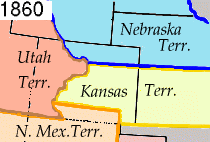
At its creation the territory extended west from the border with Missouri to the summit of the Rocky Mountains, with its western edge often described as the western boundary at the high plains and mountain divide. Its north–south limits were the 40th parallel north and the 37th parallel north. These lines placed most of the interior plains and river valleys under territorial administration and included much of what later became eastern Colorado, a region sometimes referred to in official acts and maps as the eastern region of the former Kansas Territory. The summit or continental divide is noted in contemporary descriptions as the summit of the region.
Political conflict and governance
The provision for popular sovereignty provoked a migration of competing settlers and political organizers. Proslavery advocates from neighboring states and antislavery settlers—some sponsored by northeastern organizations—sought to control territorial elections and constitutions. The clash produced episodes of violence and intimidation commonly grouped under the term "Bleeding Kansas." Competing constitutions and parallel governments appeared, most notably the proslavery Lecompton movement and free-state efforts centered at Topeka. Events in the territory helped shape national party politics and energized movements in both the North and the South.
Settlement, institutions, and people
Settlement varied from relatively dense farming and river settlements near the Missouri border to sparse ranching and mining claims toward the west. Territorial institutions included an appointed governor, a territorial legislature, and courts responsible for land claims and civil order. Indigenous peoples already present on the plains and in river valleys were affected by growing settlement; treaties and removals in preceding decades continued to shape the region's demography during the territorial period.
Transition to statehood and legacy
After years of violent contest and political maneuvering, on January 29, 1861, Congress admitted Kansas as a free state, ending the Territory of Kansas as an administrative unit. The western portion had already been reorganized; the Territory of Colorado was created in February 1861, finalizing many boundary changes. The Kansas Territory left a complex legacy: it was a testing ground for popular sovereignty, a catalyst for national political realignment, and a stage for the conflicts that led to the Civil War. Its history remains central to understanding mid-19th century American politics and westward expansion.
Notable facts
- The territory's north–south extent was defined by the 37th parallel north and the 40th parallel north.
- Its eastern border abutted Missouri, a key source of cross-border political intervention.
- Much of what became eastern Colorado was originally part of the territory and later reassigned.
- The role of the Kansas–Nebraska Act in creating the territory made it central to debates that shaped national parties.
- The continental summit and the plains to the west influenced travel, land use, and later territorial reorganization.
Questions and answers
Q: When was the Territory of Kansas established?
A: The Territory of Kansas was established on May 30, 1854.
Q: When did the eastern portion of the territory become a state?
A: The eastern portion of the territory became a state on January 29, 1861.
Q: Where did the borders of Kansas Territory extend to?
A: The borders of Kansas Territory extended from the Missouri border west to the summit of the Rocky Mountains and from the 37th parallel north to 40th parallel north.
Q: What is now part of Colorado that used to be part of Kansas Territory?
A: The eastern region of what is now State of Colorado was part of Kansas Territory.
Q: When was the western region separated from Kansas and made into its own territory?
A: The western region was separated from Kansas and made into its own territory, called the Territory of Colorado, on February 28, 1861.
Q: How long did it take for all parts in former Kansas Territories to become states?
A: It took about 10 years for all parts in former Kansas Territories to become states.
Related articles
Author
AlegsaOnline.com Kansas Territory (1854–1861): boundaries, conflict, and legacy Leandro Alegsa
URL: https://en.alegsaonline.com/art/52190
Sources
- historyplace.com : "The Kansas-Nebraska Act"
- civilwar.org : "The Kansas-Nebraska Act"
- kancoll.org : "Territorial History, Part 2"
- historynet.com : "Abolitionist Movement"
- kshs.org : "Bleeding Kansas"
- kshs.org : "Andrew Horatio Reeder"
- kshs.org : "Bogus Legislature"
- kshs.org : First Territorial Capitol - Kansapedia - Kansas Historical Society
- books.google.com : Thirty Years in Topeka: A Historical Sketch
- kshs.org : "Fighting Against Slavery in Kansas Territory"
- civilwaronthewesternborder.org : "Border Ruffians"
- u-s-history.com : "Bleeding Kansas: Mid 1850s - Precursor to the Civil War"
- kancoll.org : "Battle of Osawatomie"