
Araucanía (IX Region of Chile): geography, culture and economy
Overview of Chile's Araucanía (IX Region): landscapes from Andean peaks to lakes and forests, local economy of agriculture, forestry and tourism, administrative divisions, and Mapuche cultural heritage.
Coordinates: 38°45′S 72°40′W
The IX Araucanía Region (in Spanish, IX Región de La Araucanía) is one of the 15 first-level administrative areas of Chile. It occupies a portion of the country’s south-central zone and includes a mix of Andean highlands, lakes, forests and agricultural valleys. The region’s seat of government and its largest urban centre is Temuco, while the official designation of the region’s main city is indicated by the term capital.
Image gallery
5 Images


Location and landscape
Araucanía lies between Chile’s central valley and the Andes mountains. Its scenery is diverse, with native forests, volcanic peaks, numerous rivers and several important lakes. This variety supports both forestry and tourism, particularly outdoor recreation in protected natural areas.
Administrative structure
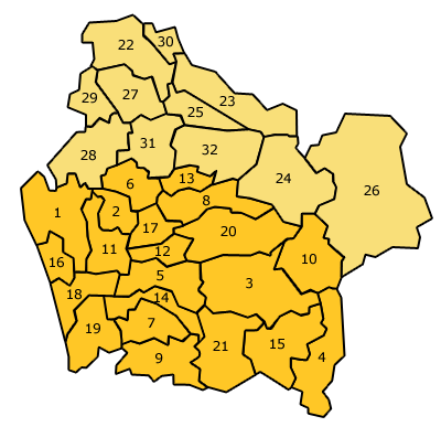
The region functions as a first-order administrative division of Chile and is subdivided into provinces and communes which manage local services and governance. Provincial capitals and municipal governments are responsible for education, infrastructure and community services within their jurisdictions.
Economy
The local economy combines agriculture, forestry, livestock and a growing services sector. Small- and medium-scale farming remains important in rural areas, while timber production and processing are significant in forested zones. Tourism related to lakes, volcanoes and cultural attractions contributes increasingly to regional income.
People and culture
Araucanía is notable for its substantial indigenous population and cultural heritage. The Mapuche people are a prominent ethnic group in the area, and many communities maintain traditional language, crafts and social practices. The Spanish name for the region reflects historical contact between European colonizers and local peoples: Araucanía — literally "place of the Araucanians" — uses a term the colonizers applied to the Mapuche, often rendered in Spanish as Araucano.
Notes
- Natural attractions and cultural sites make the region a focal point for both domestic and international visitors.
- Administrative responsibilities are shared among regional, provincial and municipal authorities to address local needs.
Questions and answers
Q: What are the coordinates of IX Araucanía Region?
A: The coordinates of IX Araucanía Region are 38°45′S 72°40′W / 38.750°S 72.667°W / -38.750; -72.667.
Q: What is the capital and largest city of IX Araucanía Region?
A: The capital and largest city of IX Araucanía Region is Temuco.
Q: What does Auracanía mean?
A: Auracanía means "place where the Araucanians live".
Q: Who were the Mapuche people?
A: The Mapuche people were a group that lived in the region, and they were given the name "Araucanian" by Spanish settlers.
Q: Where did the Mapuche people live?
A: The Mapuche people lived in IX Araucanía Region in Chile.
Q: How many first order administrative divisions does Chile have?
A: Chile has 15 first order administrative divisions.
Q: What was the name given to the Mapuche people by Spanish settlers?
A: The name given to the Mapuche people by Spanish settlers was "Araucanian".
Tags
Related articles
Author
AlegsaOnline.com Araucanía (IX Region of Chile): geography, culture and economy Leandro Alegsa
URL: https://en.alegsaonline.com/art/5201
Sources
- inearaucania.cl : "Región de la Araucanía"
- ine.cl : "País y regiones por áreas urbana-rural: Actualización población 2002-2012 y Proyección 2013-2020"
- gorearaucania.cl : "Sra. Intendenta y Ejecutiva del Gobierno Regional de La Araucanía"
- peakbagger.com : "Volcán Lanín, Argentina/Chile"