Kaiserslautern: City in Rhineland-Palatinate, Germany
Kaiserslautern is a southwestern German city of about 100,000 residents, known for its technical university, research institutions, football club, and proximity to the Palatinate Forest and international military communities.
Overview
Kaiserslautern is a mid-sized city in southwest Germany, located in the state of Rhineland-Palatinate. It sits at the edge of the Palatinate region and serves as a regional centre for education, research, commerce and culture. The city is home to roughly 100,000 inhabitants and combines urban amenities with nearby natural landscapes.
Image gallery
10 Images


Location and landscape
Kaiserslautern lies near the Palatinate Forest, an extensive wooded highland that shapes the local climate and leisure opportunities. The city grew up along small rivers and roads through the Palatinate; its setting makes it a gateway for hiking, cycling and short trips into rural southwestern Germany and toward neighbouring France.
History and name
The place name reflects its medieval origins: "Kaiser" (emperor) and the river Lauter indicate an imperial association in earlier centuries and the presence of an imperial residence site in the region. Like many German cities, Kaiserslautern experienced growth in the Middle Ages, industrial development in the 19th century and extensive rebuilding after the destruction of World War II.
Education, research and economy
Education and technology are important to Kaiserslautern's identity. The city hosts the Technical University of Kaiserslautern and a number of research institutes and technology firms. These institutions support engineering, computer science and applied research, attracting students and specialists from across the country and abroad.
Culture, sport and notable facts
Kaiserslautern has a lively cultural scene with theatres, museums and festivals. Its football club, 1. FC Kaiserslautern, has a passionate following and has played at the top levels of German football. The mix of local German residents and an international community — including a significant presence related to nearby allied military facilities — gives the city a diverse atmosphere.
Transport and practical information
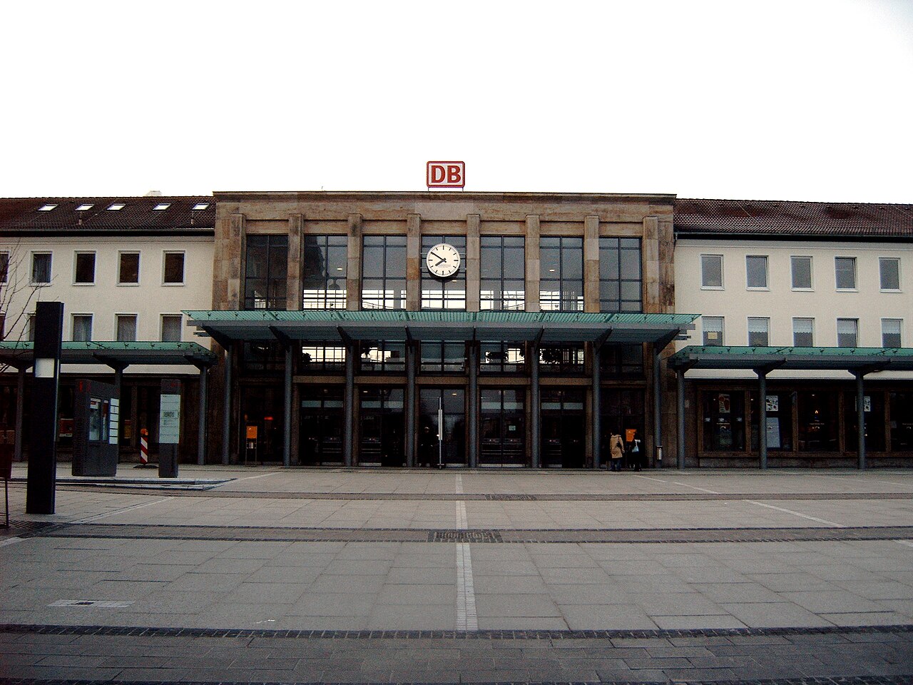
The city is connected by regional and long-distance rail links and by road, providing access to larger cities and cross-border routes. Visitors and residents benefit from green spaces close to the urban core and a range of amenities typical of a regional capital in the Palatinate area. For an introduction to the region and services, see local municipal and visitor resources.
- Key landmarks: historical town centre and remnants of imperial structures
- Typical activities: university events, research conferences, outdoor recreation in the Palatinate Forest
- Further reading and official pages: consult municipal and academic sites for details
For general context on the region and administrative links, consult information about the Palatinate and the state's official portals.

Population
Population development
→ Main article: Population development of Kaiserslautern
Kaiserslautern had a population of 97,382 at the end of 2014, making it a major center of the state of Rhineland-Palatinate along with Trier, Mainz, Ludwigshafen am Rhein, and Koblenz. In addition, there are almost 48,000 US-Americans; these are either current or soldiers, civilian employees as well as their family members who serve in Kaiserslautern and at Ramstein Air Base and live in the city and the district. The core city, without incorporated villages, has about 85,000 inhabitants.
From the middle of the 16th century until about 1800, the population was always between 1000 and 3000. In 1815, the town had 3757 inhabitants. Between 1802 and 1834 the number of inhabitants doubled to about 7000. With the beginning of the industrialization in the middle of the 19th century a strong population growth set in; in 1900 already 48,000 people lived in the city and in 1937 70,260. At the beginning of the Second World War one counted about 70,000 inhabitants, after the end of the war there were still about 56,000.
In 1957, the number of inhabitants had already increased to 86,000 and continued to rise through immigration in the following decade. As a result of the incorporation of several surrounding towns, the city exceeded 100,000 inhabitants in 1969; in 1977, 100,100 people lived in Kaiserslautern, and in 1997, 101,549. In 2000, the city's population fell below 100,000 again. Since May 1, 2009, a second residence tax of ten percent of the cold rent has been in effect; the city wanted to use this to bring about increased registrations of first residences in order to raise the population back above 100,000. As of Dec. 31, 2017, the city had a population of 100,747, according to city officials. For the same reporting date, the State Statistics Office reported 99,684 residents. Depending on the source, Kaiserslautern would thus be a major city or not. As of December 31, 2019, the State Statistical Office reported 100,030 inhabitants, making Kaiserslautern a major city again.
Religion
Confession statistics
As of April 30, 2021, of the residents, 31.2% are Protestant, 24.3% are Catholic, and 44.5% belong to other or no religious denominations. As of December 31, 2019, of the 101,063 residents, 32.3% were Protestant, 25.2% were Catholic, and 42.4% belonged to other or no religious denominations. Two years earlier - 2017 - of the 102,237 residents, 35,320 - equivalent to 35.3% - were Protestant and 27,103 - equivalent to 27.1% - were Catholic.
Christianity
Catholic churches are located in the city centre: the church of St. Martin, the church of Maria Schutz, in the district of Mölschbach the daughter church of St. Blasius and in Hohenecken the Rochuskirche and the Rochuskapelle.
Protestant places of worship include the Christuskirche, the Kleine Kirche and one in Siegelbach.
In addition, there is a so-called willow church on the grounds of the garden show. In the settlement Stockborn, which belongs to the district Erfenbach, many inhabitants are of Mennonite faith.
Judaism
Kaiserslautern was the seat of a district rabbinate. From March 1933 the time of National Socialism also affected Kaiserslautern. At that time the city had 648 Jewish inhabitants, in 1932 there had been 765. Because of the harassment and economic boycott measures that began in 1933, many Jews left Kaiserslautern.
From 1894 to 1896 the synagogue was built in the former Frühlingsstraße - present name Luisenstraße - according to plans of the architect Ludwig Levy in Moorish-Byzantine style. It shaped the cityscape of Kaiserslautern at that time and was considered a landmark. In 1938, the Jewish Community was forced to hand over the synagogue to the city, which had the building demolished. In August of the same year, its remains were demolished, as it did not fit into the cityscape of the National Socialists.
During the November pogroms of 1938, numerous shops and homes of Jewish citizens were vandalized and looted before the eyes of the police, Jewish citizens were mistreated, and their property was confiscated ("Aryanized").
Most of the Germans of Jewish faith still living in Kaiserslautern were deported to the Camp de Gurs in southern France on 22 October 1940 in the Wagner-Bürckel action. Only a few managed to escape from there, many died of hunger and disease. In August 1942, transports of the survivors to the gas chambers of Auschwitz and Lublin-Majdanek were assembled. Of the 90 Jews who had still lived in Kaiserslautern in 1939, at least 78 were murdered after their deportation. The Jewish Cemetery is located in the east of the city.
In 1980, the site of the former synagogue was officially renamed Synagogenplatz. In 2001, it was virtually reconstructed in a project by the Technical University of Darmstadt. In 2002, a memorial to the Jewish victims of National Socialism in Kaiserslautern was erected on the foundation of the blown-up synagogue.


Cityscape
Due to its strategically important location on one of the few passes between the Rhine and the Moselle (via regalis), the city was repeatedly destroyed in the course of its history. The rapid industrialization of the city in the 19th century, the bombing during the Second World War, the traffic-oriented reconstruction after the war and the redevelopment of the old town (area redevelopment) in the late sixties and early seventies also led to substantial losses of historical building fabric.
Nevertheless, a number of remarkable individual buildings, ensembles and historic layouts have survived, even if they no longer form part of a historic urban ensemble.
Middle Ages and early modern times
Remarkable buildings from the Middle Ages and early modern times are the Protestant collegiate church and the Catholic St. Martin's Church as well as remains of the Barbarossa Castle with Casimir Hall. Some remains of the town wall are preserved and a side wing of a Gothic patrician house, hidden in the backyard of Marktstraße 8.
Baroque buildings can be found around Martinsplatz, in Klosterstraße (Bistumshaus), at Rittersberg (Gasthaus Ritters) and in Schillerstraße (Gasthaus Zum Spinnrädl). Buildings of the classicism can be found among others in the Friedenstraße (former cemetery chapel), in the Marktstraße (Adler pharmacy), in the Scheidstraße/corner Matzengasse and in the Steinstraße 49 (Villa Karcher).
The period up to the First World War
Most of the preserved cultural monuments date from the second half of the 19th century until the end of the Empire. Typical for the Wilhelminian development is the block building with eaves houses. Remarkable are the Fruchthalle, now used as a concert hall, the Gewerbemuseum (today Museum Pfalzgalerie Kaiserslautern), the Marienkirche and the Apostelkirche, furthermore the monument zone around the Stadtpark as well as the villa quarter in the Benzinoring/Villenstraße. Representative administrative buildings of the Wilhelminian period are the former main post office in Karl-Marx-Straße (today Deutsche Telekom), the former district command (today police headquarters) in Logenstraße, the royal main customs office (today tax office) in Eisenbahnstraße, the administrative headquarters of the Palatine Railways in Eisenbahnstraße 73 (today privately used) and the neo-baroque barracks of the 23rd Royal Bavarian Infantry Regiment in the east of the city.
As an industrial monument, the buildings of the former Kammgarn spinning mill are listed. The extensive grounds are now part of the horticultural show; the former boiler house is home to the Kammgarn Cultural Centre, and parts of the administrative buildings are used by the University of Applied Sciences.
Architectural monuments of the Art Nouveau style are rare in Kaiserslautern. The former Hotel Brenner opposite the railway station, the Goethe School, the residential building at Schumannstraße 10 and the commercial building at Steinstraße 15 are worth mentioning. Remarkable are two rare examples of very early cinema theatres (Union from 1911, Kerststraße; Central from 1913, Osterstraße), which are still used as cinemas today.
Of urban planning interest is Eugen Bindewald's expansion plan of 1887, which includes the ring roads in the east of the city (Barbarossaring, Hilgardring, Benzinoring), the quarter around today's Kolpingplatz - a roundabout with radial roads - as well as the city park and Marienplatz with St. Mary's Church in the west of the city. The latter forms the centre of the star-shaped streets leading up to it. In 1912, the forest cemetery was laid out according to plans by Hermann Hussong.
Interwar
Hermann Hussong was one of the personalities who have shaped the cityscape to this day. The new version of Bindewald's city expansion plan (1913) as well as the designs for the development of the Pfaffenberg and the Lämmchesberg come from him.
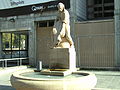
From 1919 onwards, Hussong built the castle-like residential complex on Fischerstraße, which was paid for by the German Reich as a reparation payment and was originally intended as an officer's residence for the French army of occupation. After the French had renounced the complex, it fell to the Gemeinnützige Baugesellschaft (Bau AG), founded in 1921. On behalf of Bau AG, Hussong built numerous residential buildings to combat the housing shortage. The expressionist Bunte Block in Königstraße/Marienplatz, the so-called Rundbau (Königstraße) over a D-shaped ground plan, the Grüne Block (Altenwoogstraße/Mannheimer Straße) over an A-shaped ground plan and the Pfaffsiedlung (Pfaff housing estate) are of monumental importance. The exhibition hall on the site of today's Volkspark was also designed by Hussong; the complex was destroyed by bombs in 1945, only the monumental group of figures of the horse tamer has survived.
The idea of the garden city was implemented in Kaiserslautern in the Bahnheim, a housing estate in the neighborhood of the Reichsbahnausbesserungswerk. In 1928, the first building in steel skeleton construction was erected at Schillerplatz (the Fleischbein House with the Schillerplatz Pharmacy on the ground floor), and with the main post office at the railway station designed by Heinrich Müller, an outstanding example of the Bavarian Post Office Building School, the most important expression of New Building in Bavaria, was created in 1930. An interesting interpretation of Gothic style elements in the Expressionist spirit is shown by the Catholic Minorite Church of Maria Schutz (Gelöbniskirche) from 1928/29 on Messeplatz in the east of the city.
The architecture of the National Socialist era includes large housing estates in the east and west of the city, as well as various barracks. Buildings of monument rank are extensions of the Kammgarnspinnerei and the motorway bridge over the Waschmühltal. Because of the elevation to the Gauhauptstadt in 1939, parade and marching grounds were planned; in anticipation of this, the synagogue was already demolished in the summer of 1938. However, the transformation came to a halt during the war when Saarbrücken became the new capital of the Saarpfalz Gau.
Postwar
Towards the end of the war, almost two thirds of Kaiserslautern's inner city was destroyed by bombing. The reconstruction of the city after 1945 followed the traffic requirements of the American occupation army. In order to create breakthroughs and widen streets, much of the remaining building fabric was demolished. When the buildings were rebuilt, they were mostly restored in simplified forms. The new buildings are a result of the sober reconstruction period and the scarce financial resources; today they appear banal. Structurally significant buildings of this period are the Evangelical Christ Church (1957/58) and the Evangelical Paulus Church (1958-60), the vocational school in Martin-Luther-Strasse (1954-56), the former French officers' mess at Altenhof (1955/56), the office building of the Bavarian Mortgage and Exchange Bank in Fackelstrasse (1956/57), the district administration (1959-60) and the 84 m high town hall (1963-1968), at the time the highest town hall in the Federal Republic.
In order to provide accommodation for the American soldiers and civilians, a residential area with apartment buildings was created with the Vogelweh in the west of the city. In the 1960s, the residential area Bännjerrück was built in the neighbourhood. Furthermore, the Betzenberg in the south and the Fischerrück in the northwest of the city were developed with high-rise housing estates. With the founding of the university, the university residential area was designated in a mixture of multi-family and single-family houses.
Americans in and around Kaiserslautern
In addition to the official figures of the population registration offices, almost 48,000 U.S. Americans (soldiers, former soldiers, American civilian employees and their family members) live in the city and district of Kaiserslautern and are organized in the Kaiserslautern Military Community (KMC). The strong American presence (the Kaiserslautern area is the largest American settlement outside the USA) is related to the Ramstein Air Base in Ramstein-Miesenbach, about 10 km west of Kaiserslautern, as well as other US Army and US Air Force facilities in the Kaiserslautern area.
New residential areas were created especially for the American soldiers, such as Vogelweh in the west of the city, where the street names are American and bear names such as Third Avenue or Florida Loop.
Active American military bases in Kaiserslautern (as of 2018) are the 21st Sustainment Command (Exp), the Community Facility, Daenner Kaserne (with General Support Center - Europe, Movement Control Team and Support Center), Einsiedlerhof Training Anx 49° 26′ 24″ N, 7° 39′ 54″ E49.447.665, the Einsiedlerhof Air Station Flight Simulation, Hill 365 Radio Relay Fac, Army Depot, Equip Spt Center, Family Housing Anx No 3, Kapaun Administration Anx, the Kleber Barracks (with Transportation and Kaiserslautern Legal Center), the Panzer Barracks (GE642), the Pulaski Barracks (with Base Support Battalion), the Rhine Ordnance Barracks, and the Vogelweh Family Housing Annex.
Americans are an important economic factor for the city and district of Kaiserslautern, and the local German economy and administration have adapted to Americans as customers, consumers and tenants. For example, restaurant menus are often bilingual, the U.S. dollar is often accepted as a means of payment alongside the euro, and restaurant bills are sometimes issued in both currencies. The city administration has also adapted to the situation and sends out tickets for traffic violations with a demand for payment to American traffic offenders in English. However, the city does not accept US dollars. In stores, clerks are often bilingual. Among American soldiers and their dependents, the term K-Town ('kā 'tau̇n) has come to mean Kaiserslautern. Thus, some US Army street signs are designated with it. The name also appears in songs by songwriters Reinhard Mey (Alle Soldaten woll'n nach Haus, album: Farben, 1990) and Franz Josef Degenhardt.
Other cultural monuments
→ Main article: List of cultural monuments in Kaiserslautern
In the middle of the Palatinate Forest in the southern part of the city is the Humbergturm, which functions as an observation tower.
The two best-known castles in the town area are Hohenecken Castle, also in the Palatinate Forest, which overlooks the south-western district of Hohenecken of the same name, and Beilstein Castle, which lies to the east of the town and is hidden in the forest.
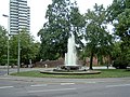
In the city centre there is the Kammgarn Cultural Centre, which is housed in the buildings of the former Kammgarn spinning mill near the current garden show grounds, and the Kaiserbrunnen (Emperor's Fountain) at the Mainzer Tor, which was created by Gernot Rumpf in 1987.
The Museum Pfalzgalerie Kaiserslautern was originally intended as a trade museum and today houses works by Palatine artists. The collection focuses on graphic art, paintings and sculpture of the 19th and 20th centuries, especially German Impressionism and Expressionism. There is also a collection of arts and crafts from the 16th to the 19th century.
Nature, recreation and parks
There are numerous natural monuments in the city area. Especially the south of Kaiserslautern is located in the nature park Pfälzerwald, which is part of the cross-border biosphere reserve Pfälzerwald-Nordvogesen.
In the middle of the Palatinate Forest are the Wildpark am Betzenberg and the Fritz Walter Stadium on the Betzenberg, which serves as the venue for home games of 1. FC Kaiserslautern.
In the city centre is the garden show, which emerged from the first state garden show in Rhineland-Palatinate and is home to the largest dinosaur exhibition in Europe.
In the north of the city in the district of Siegelbach are the Kaiserslautern Zoo and a few kilometres to the east the Waschmühle open-air swimming pool with the second largest water pool in Europe after Frankfurt's Brentanobad.
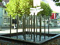
A special sight is the Japanese Garden Kaiserslautern. It is one of the largest Japanese gardens in Europe.
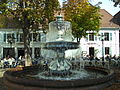
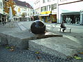
Fountain
Around 50 fountains are open to the public in the city area. The most famous ones are shown in the picture gallery below.
· 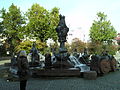
Imperial fountain at the Mainzer Tor
· 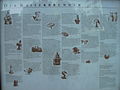
Legend of the Kaiserbrunnen
· 
Swan fountain at Martinsplatz
· 
Spittelmüller fountain at the Stiftsplatz
· 
Fountain at Schillerplatz
· 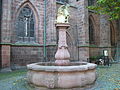
Fountain at the collegiate church
· 
Giant fountain in the pedestrian zone
· 
Torch Fountain


Related articles
Author
AlegsaOnline.com Kaiserslautern: City in Rhineland-Palatinate, Germany Leandro Alegsa
URL: https://en.alegsaonline.com/art/51912
Sources
- destatis.de : "Alle politisch selbständigen Gemeinden mit ausgewählten Merkmalen am 31.12.2018 (4. Quartal)" · web.archive.org
- statistik.rlp.de : "Gemeinden in Deutschland mit Bevölkerung am 31. Dezember 2015"